
| No | Name | Description |
|---|---|---|
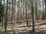 |
Aizaudzis un purvains ezers - Ļūbasts, ar grūti pieejamiem vai nepieejamiem krastiem. Dabas vērošanai šobrīd nepiemērota vieta. Galvenās aizsargājamās vērtības - dažādas putnu sugas, t.sk. dzērves un melnie zīriņi.
|
|
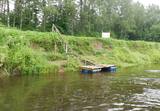 |
Atpūtas vieta Gaujas upes kreisajā krastā, pusceļā starp Virešiem un Aņņu tiltu (Gaujiena-Valka; P23). Pieejams galds maltītēm, ugunskura vieta, sausa malka, telšu vietas, tualete. |
|
 |
Located a few kilometres from Jūrkalne in a log building with a Latvian style interior. The menu includes Latvian and European cuisine, as well as fish and game meat dishes prepared from natural local produce in cooperation with local producers. Offer also includes pastries and sweets. |
|
 |
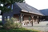
The farm "Krūmiņi", popularly called the Bread House, is a place to participate in real rural bread baking rituals, make dough and bake pies yourself, get to know grains, explore grain products, create Latvian strength signs and learn about centuries-old traditions related to bread. The heartfelt owners of the farmstead in the old barn also offer to enjoy the anniversaries, unusually celebrate their special holidays and enjoy extended life skills programs with soup cooked by the fire and watching natural events. When visiting the Bread House, you will learn why bread is baked here with the taste of freedom for almost 100 years, and the merry owners of the house know best to tell about it. |
|
 |
The Alejas bakery and guest house is located 0.5 km from the centre of Rucava. The bread here is made with natural sourdough and baked in a wood oven. Various types of rye bread (ordinary rye bread, sweet and sour rye bread with or without other ingredients, rye bread with fruit, etc.), rye bread and garlic croutons, and various types of white bread. By prior arrangement it is possible to buy bread to take home. |
|
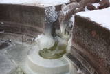 |
Built in the turn of the19th to 20th century. Next to it-on the right bank of the river Vēršupīte, there is located one of the most popular Latvian sulphur water springs, called "Small lizard". The spring runs out from a stone-designed lizard sculptured in 1949 (Sculptor J. Bajārs). Its water is healthy for using both internally and externally. Not far from the pavilion there can be found Jānis Lībietis alley sign. J. Lībietis worked in the position of a director for the sulphur water spring authority of Kemeri from 1928 to 1944. |
|
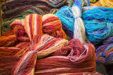 |
This is the only factory in Latvia that offers the full processing of wool, and it has been open since the late 19th century. There is a workshop in Dundaga where woollen blankets and pillows are sewn. |
|
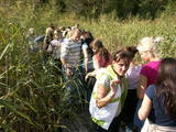 |
Kaut arī Augštaitijas nacionālo parku uzskata par floristiskā ziņā ļoti bagātu teritoriju, šī ir vienīgā vieta, kur varam iepazīt augu valsts bagātību. To īstenot palīdz takas malās izvietotie informācijas stendi. 3,8 km garās lokveida takas sākums ir meklējams Palūšē, Lūšu (Lūšiai) ezera galējā austrumu punktā. Taka ved gar ezera krastu, mežainām kāpām, nelielu strautu ielejām un pa purvāju. Nenomaldīties palīdz krāsu marķējums uz koku stumbriem. |
|
 |
Atrodas Daugavas prospektā 10, starp Rīgas – Daugavpils šoseju (A 6) un Kalēju ielu. Dievnams celts laikā no 1931. - 1933. g. (arhitekts: Pēteris Kundziņš). Padomju gados tajā bija izvietota Latvijas Valsts bibliotēkas grāmatu glabātava. Pateicoties draudzes aktivitātēm 1989. g., ēku atjaunoja. Tagad tā kalpo savam pamatmērķim. |
|
 |
Eins der eindrücksvollen Meteoritenkraterfelder Europas. Der Hauptkrater ist 22 m tief, Durchmesser – 110 m. Der ungefähre Zeitraum des Meteoriteneinschlags liegt ung. 7500-Jahre zurück. |
|
 |
Naissaar is a small island near Tallinn which was exclusively used by the Soviet military from 1945 to 1993. Attractions on the island include walking trails, varied habitats, a narrow-gauge railway, fortifications from the early 20th C, and a Soviet naval mines factory. |
|
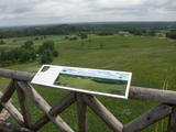 |
Karulas augstienes augstākais reljefa punkts (137 m.vjl.), kas virs tuvākās apkārtnes paceļas par ~ 60 m. Torņa kalnā ir uzbūvēts skatu tornis ar ļoti plašu apkārtskatu. Uz tā platformas ir novietoti panorāmas fotoattēli, kuros atzīmēti zīmīgākie plašākā apkaimē redzamie objekti – apdzīvotas vietas, pilskalni, baznīcu torņi u.c. Turpat izveidota atpūtas vieta un meklējams Rebases ainavu takas sākums. |
|
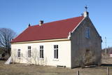 |
This is a simple one-story building with a cross on its roof. The Pitrags congregation was established in 1890, but the church was built in 1902. It was restored after a World War I fire in 1925 and 1926, and restored again during the period of Latvia's restored period of independence. |
|
|
|
One of the richest sources of sulphurous water in Latvia.
|
|
 |
The café is in the centre of Aglona on the edge of the Dagda road (P60). |
|
 |
The farmstead Riveni specializes in fruitgrowing and the products of reprocessing those – dried apples, apple juice. |
|
 |
Iespēja patīkamā atmosfērā baudīt ļoti gardu ēdienu. . Starp tiem arī Lietuviešu tradicionālo ēdienu. Ir dienas un vakara īpašie piedāvājumi. |
|
 |
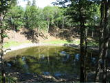
Another area where the manifestations water-soluble lime in the earth can be found. As the lime dissolves, there are empty areas underground which eventually collapse. To the East of Skaistkalne is a leisure area where dry and full holes of various sizes can be found.
|
|
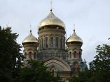 |
This church was built between 1900 and 1903 in the Byzantine style, and was meant for the local military garrison. The church, which was built to honour St Nicholas, patron saint of all seamen, and it was consecrated in the presence of Tsar Nicholas II. The ornate building was sacked by the Germans during World War I. During Latvia’s period of independence, the cathedral was used by the local military garrison. The Soviet military, in turn, turned into a sports hall, a cinema for sailors, and a warehouse. There are stories to say that Soviet soldiers broke off bits of the golden mosaic of the icons in the church. The building has now been returned to an Orthodox congregation. The builders of the cathedral used a unique way of pouring cement, which is why there are no supporting columns in the church. Instead, its weight is bolstered by its walls, with four arched vaults supporting them. It is the tallest Orthodox cathedral in Latvia at this time.
|
|
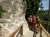 |
In terms of shape, this is one of the most diverse areas of uncovered sandstone in Latvia. Found on the right bank of the Gauja river, the Sietiņiezis is up to 15m high. Small holes that can be seen in the cliff face are created by single and protected insects, which carve tiny caves in the cliff for their caterpillars. A circular and well appointed trail, with stairs, has been installed. It is 1.5 km in length and will take an hour or so to traverse. Objects are in the Gauja National Park.
|
|


