
| No | Name | Description |
|---|---|---|
 |
Eine der schönsten Landkirchen Estlands, wurde ursprünglich als Zufluchtsort verwendet. Wurde im Stil der Frühgotik gebaut. Die Wandmalerei aus dem Jahr 1330. |
|
 |
Vilsandi bāka sāka darboties 1809. g. Ja uzmanīgi palūkojas uz torņa, labi redzams, ka tas ir vairākas reizes paaugstināts. Tagadējās bākas augstums ir 37 m, bet gaismas elements atrodas 40 metrus virs jūras līmeņa. Bāka ar apkārtējām ēkām ir apskatāma tikai no ārpuses. Ja pa Vilsandi arhipelāgu ceļo ar jūras laivu vai citu peldlīdzekli, tad bāka kalpo kā ļoti labs orientieris daudzo salu, līču un pussalu labirintā. No bākas redzama jūras krastā uzceltā glābšanas stacija. Pateicoties tai, Vilsandi ūdeņos izglābti 29 cilvēki, 2 suņi un 1 kaķis. Tā stāsta vietējie. |
|
 |
Tiek uzskatīta par vecāko alus darītavu Ziemeļeiropā. Tā tika uzcelta 1878. gadā, un tās pirmais īpašnieks bija grāfs Emanuels fon Zīverss (Sievers), Cēsu pils muižas saimnieks. Savukārt 1922. gadā alus darītavu pārpirka Cēsu uzņēmēji un sāka tur ražot arī vīnu, sulas un minerālūdeni. Uzņēmums "Cēsu alus" šeit alu un atspirdzinošus dzērienus ražoja no 1976. līdz 2001. gadam, bet šobrīd tas ir pārcēlies uz jaunām telpām. Šobrīd ēkā tiek organizētas dažādas izstādes, kā arī ēku var apskatīt no ārpuses. |
|
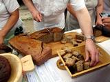 |
"Cēsu maize" is located in the very heart of Cēsis, Riga street 18. Bakery makes bread from organic cultivated grains in Latvia and with natural grass. The offer includes products such as: Spelled whole wheat bread, whole wheat bread with sun-dried tomatoes and olives and spelled sweet bread. |
|
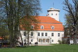 |
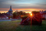
The history of Cēsis begins at the Riekstu hill, which is 18 m high and the surrounding area. There was a wooden castle built by the Vendian tribe that stood there from the 11th to the 13th century. The hill is in the central part of the castle’s park, and it offers a fine view of the park, a pond and the ruins of the Cēsis Castle. A long staircase leads to the hill. The Cēsis Castle was built in the early 13th century as the residence of masters of the Livonian Order, and it was one of the most fortified forts in the Baltic region. Alongside is the New Cēsis Castle, which was built in 1777 in a place where gate fortifications had been before. The building houses the Cēsis Museum of History and Art, and an annex contains the Castle Visitor Centre and the Cēsis Tourism Information Centre. From the tower of the castle, we get a good view of the castle ruins, St John’s Lutheran Church and the northern stretches of the city. Opposite the new castle is the stable of the Cēsis Castle Estate and a wheelhouse (both from the first half of the 19th century). Today these house the Cēsis Exhibition Hall. Other buildings include a granary, a hut for coachmen and an old brewery. On the other side of the street is the romantic May park, which was installed during the 1830s. Streets in Cēsis include Lielā Katrīna, Mazā Katrīna, Mazā Kalēju, Kalēju and Lielā Līvu streets and Līvu square with wooden buildings from the late 18th and early 19th century. Torņa Street stretches along the walls of the Medieval castle. Outside the church is a sculpture, “As the Centuries Pass By,” and legend has it that anyone who rubs the lantern of the Old Time Man can see the future. One of the most impressive buildings in Cēsis is St John’s Lutheran Church, which was built in the late 13th century by the Livonian Order. The Roman-style three-segment basilica has elements of Gothic design and a 65 m steeple that was installed in 1853. The building was reconstructed several times during the 20th century and contains grave plaques relates to masters of the Livonian Order and local bishops. The pulpit dates back to 1748, the oak altar was manufactured in 1858, and the altar painting “Crucified One” was painted in 1862. The windows of the altar part of the church contain artistically valuable stained glass. The organ was manufactured in 1907 by the E.F. Walker firm, and it is one of the best concert organs in Latvia. The solar clock with the number 1744 is in the south-wester corner of the church. It is worth scaling the viewing tower of the church. At its foot is Rose Square, which was a market square from the mid-13th century until 1927 and was restored in 2008. This is the central square in the city. During the Middle Ages, a punishment pole and the city well were here. Rīgas Street has been the main street in the old part of the city from the very start, and here we find most of the architecturally distinguished buildings from the 18th and 19th century – the former city hall, the Fābers house and the Princess house. At one end of the street is Liv Square, where there a church, cemetery and the Rīga gate in the city’s walls existed in the 13th century. Today the square is decorated by a lighted fountain at a place where a well was found in the 13th century. On the other end of the street we find a reconstruction of the foundations of the Rauna gate from the 14th and 15th century, offering a good look at Medieval walls and the size and strength of the gates. It is commonly claimed that the national flag of Latvia was born in Cēsis, but it must be emphasised that the flag that is mentioned in chronicles was designed in Cēsis in 1279 as the ideological prototype of the current Latvian flag, while the story of the first national flag actually comes from Valmiera, where it was sewn in 1916. |
|
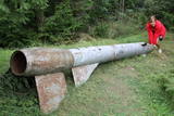 |
Der weiteste Nordpunkt der Juminda Halbinsel mit einer Raketen-Attrappe der Sowjetarmee, der alten Grabstätten, dem Juminda-Leuchtturm und einem Denkmal für die Opfern des Zweiten Weltkriegs. |
|
 |
Meklējamas Lizuma ciema dienviddaļā. Tās ir vienas no retajām vējdzirnavām (1880. g.), kas saglabājušās labā stāvoklī. Mūsdienās dzirnavas ir gleznotājas Ilonas Brektes īpašums. |
|
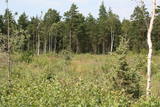 |
Similar as Alsungas mezi (Alsunga forests) – is not intended and appropriate for visits. A narrow path of the restricted area can be seen from the gravel road – Saka-Apriki. Nature restricted area established mainly for protection of Erica tetralix (often called "cross-leaved heath") and it is one of the most important growing places.
|
|
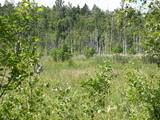 |
This swampy territory used to be part of a Littorena Sea lagoon, and it is a place where many rare and protected birds such as woodpeckers live and nest. Territory is hard to reach although some of the territory can be surveyed from the Tukums-Kolka road. Wet meadows is called "lankas" in Kurzeme region. |
|
 |
Das größte Wissenschaftszentrum Baltikums mit Möglichkeiten, mitzuarbeiten und zu experimentieren. Ein Planetarium. |
|
|
|
Atrodas Kokneses tūrisma centra telpās (1905. gada ielā 7). 160 cm garais un 120 cm augstais makets ir Vittingenas (Vācija) dāvinājums Koknesei, atzīmējot 10 gadu sadraudzības jubileju. Šāda Kokneses pils izskatījās ap 1701. gadu. |
|
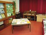 |
Local History Museum of Bērzgale was founded in 1988. There is
the memorial room of writer Antons Rupainis (1906 – 1976), the exposition of municipality history, its famous
people and cultural-historical traditions.
Working hours: Mon– Fri : 9.00 – 12.00,13.00 – 17.00, Sat., Sunday : on request |
|
 |
This is a part of Latvia in which various manifestations related to layers of earth made up of water-soluble lime can be found. The most unusual elements here are Lake Vecezers and Lake Linezers. The water of the latter lake has flowed underground several times over the last few decades, with the remaining lake hole as much as nine metres deep. No one can fully explain how this happens. A tourist trail encircles Lake Linezers.
|
|
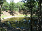 |
Eins der eindrücksvollen Meteoritenkraterfelder Europas. Der Hauptkrater ist 22 m tief, Durchmesser – 110 m. Der ungefähre Zeitraum des Meteoriteneinschlags liegt ung. 7500-Jahre zurück. |
|
 |
Atrodas galvenās Kuldīgas gājēju ielas malā. Sadarbojas ar vietējiem zemniekiem un piedavā Kurzemes novadam raksturīgus ēdienus, kā arī ēdienus no dažādu pasaules valstu receptēm. |
|
|
|
(V-1279) linked Kuldīga and Alsunga before a new road was built. The lovely gravel road weaves through forests and farmland. During appropriate weather, it can be used as an alternative road to learn about the landscapes of the Suiti region. You can also bike down the road. |
|
 12 days
|
The duration of the route is up to 12 days with self-drive transportation. The total distance is about 1 500 km.
|
|
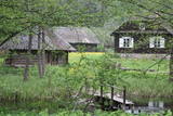 |
Salos, Vaišnoriškė, Strazdai, Šuminai sind die bewohnten Dörfe im Augštaitija- Nationalpark, in denen historische Einzelgehöfte mit Holzgebäuden erhalten sind. |
|
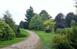 |
Work on this arboretum began in 1958 at a local forest research station that is near the village of Vaišvidava. The arboretum collects and exhibits various local and imported plants for scholarly, educational and decorative purposes. The arboretum covers some 50 ha of land, with more than 800 types of plants. Some parts of the arboretum have rare and protected trees and bushes, and these can only be visited if you contact the arboretum in advance. |
|
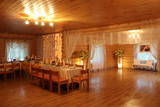 |
The farm engages in cattle breeding, fruit and vegetable growing, and production and processing of milk and meat. Contact the farm in advance to purchase homemade products, learn to make cheese, and bake your own bread on the basis of ancient recipes. This farm is part of the culinary heritage of Latgale. |
|


