
| No | Name | Description |
|---|---|---|
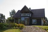 |
Ciemos gaidīti gan pāri, gan ģimenes, gan draugu kompānijas. Lauku sēta sastāv no piecām ēkām. Neskartā daba un tīrais gaiss ļaus atpūsties pilnīgā klusumā. Ap 50 m no Šventosios (Svētās) upes atrodas galvenā ēka, kurā ir divas guļamistabas ar tualeti un dušu nakšņošanai līdz 10 personām. Pirts namiņš būs ērts draugu lokam līdz 9 cilvēkiem. Pieejami trīs jauni VIP namiņi 2-4 cilvēkiem upes krastā. Piemērota vieta kāzu, dzimšanas dienu u.c. svinībām. |
|
 |
The property is located in the picturesque Karula National Park (Karula Rahvuspark). Here you can have a meal and spend the night. The food is mainly prepared from local ingredients in the household kitchen. The farm also breeds bulls. |
|
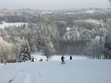 |
Gaiziņkalns Hill is the highest hill in Latvia, and it is a typical example of the hillocks of the Vidzeme highlands. This is a place of wonderful landscapes, even though there are not all that many good viewing areas. At the centre of this park is Gaiziņkalns Hill itself – the highest place in Latvia and the second highest in the Baltic States (311.6 metres above sea level). The viewing tower, alas is not open to the public, because it is in dangerous condition. There is a well-appointed hiking trail around Gaiziņkalns Hill, and during the winter the hill and its surroundings are popular for downhill and cross-country skiing. Lake Viešūrs (Lake Kaķītis) is popular among licensed fishermen. This territory is part of a region of protected landscapes around Vestiena. |
|
 |
Auf dem Urbo-Hügel befindet sich der 1953 ronovierte schönste Leuchtturm an der Küste Litauens. Das Licht von diesem Leuchtturm kann man in einer Entfernung von 22 Seemeilen sehen. |
|
 |
The open-air museum was proposed in 1992 by the sculptor Ojārs Arvīds Feldbergs, and it is located on the banks of the Ancient Abava River valley and on land that was once part of the Firkspedvāle and Briņķpedvāle estates. The park features contemporary art, and the museum also organises symposiums, creative workshops and other events. |
|
 6 days
|
This route will allow you to see Latvia's most impressive medieval castles or their ruins, as well as outstanding manor houses from aristocratic estates dating back th the 18th and 19th century. The mansion of the Ungurmuiža Estate is one of the only wooden palaces left in Latvia from those that were built in the early 18th century. The ruins of the Cēsis Castle are among the most impressive Medieval ruins in the country. The tower of the Turaida Castle offers panoramic view of the ancient Gauja River Valley. About one-half of the route passes through the Gauja National Park. You will arrive at the place where the oldest crossing of the Baltic rivers exists - the rafts which transport people across the river are still powered by the stream itself. |
|
 |
The former military zone in this location is not in use at this time, and there is no specific information about what it was used for in the past. The territory is privately owned and is not open to visitors.
|
|
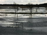 |
This is an open territory which is 3.5 km long and 2 km wide. It is located on the left bank of the Lielupe River between the village of Pavasari and the Odiņi homestead. The polder was established during the Soviet era to obtain farmland, and back then it was used very intensively. Today, it is slowly becoming overgrown, and despite this, this is one of the most important locations in Europe for corn-crakes. A gravel road crosses the polder from the North to the South, and this is an excellent place to hear the songs of the corn-crake. |
|
 |
The Kassari Island is the fifth largest Estonian island, and it is found to the South of the Hiiumaa Island. There are two dams between the two islands, and a road for motor vehicles has been installed atop them.
|
|
 |
The farm produces mixes involving seeds from various plants – ones which are very healthy in terms of human nutrition. Visitors will hear stories, purchase products and taste hemp pancakes. The tour takes place at the “Mazais Ansis” saloon. |
|
 |
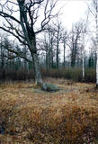
The forests of Zvārde are located on land which used to be a Soviet air base. The territory was unpopulated and was not accessible to civilians. The vast area includes various types of forest - boreal forest, bogs of black alder, etc. The fact that the military used to control the territory is one of the reasons why the forests of Zvārde are a location where many rare and protected birds live, reproduce and find food. Some of the elements of the old air base are still in place, including a unique surveillance platform. It is recommended that visitors to the area drive only along general use roads. |
|
 |
You are offered horse-riding along the picturesque forests and individual horse-riding lessons. |
|
 |
This territory was established to protect the lovely central section of the Neries River, local species, and Lithuania’s largest oak forest.
|
|
 |
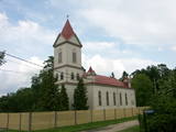
The Krimulda Lutheran church is seen as one of the oldest in Latvia. It was built in the early 13th century, soon after the territory of Kubasele was conquered. Over the subsequent centuries, it has been rebuilt many times. Alongside the church is a meditation maze called "Lily Blossom." When the Liv warrior Kaupo fell in battle near Vīlande in 1217, his remains were supposedly interred at the church. Local residents, true, describe a small hillock that is near the church as the grave of Kaupo. The site is located alongside the little Runtiņupīte (Runtiņš) river, on the right bank of which is a manmade cave that is approximately seven metres deep. It is the Kubesele Cave or the Runtiņala Cave. The Kubesele castle hill is on the left bank of the Runtiņupīte. The Kubesele Nature Trail starts at the church. If you hike down the trail, you'll see all of the aforementioned objects and others. The trail leads to the Gauja River where, on the right bank, is the Great (Runtiņš) Rock. Nearby you'll find anchor blocks installed by rafters on the river. |
|
 |
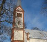
Located at 10 Sēravotu Street. The historicism style building is built from wood in 1889 and it is the newest of the three churches in Ķemeri. It is possible to see the church from the inside on the days of worship services. On other days-from the outside. |
|
 |
Atrodas Rīgas – Daugavpils autoceļa (A 6) 118. kilometrā. |
|
 |
"The heart of Latgale", where during the 9th – 12th century stood a fortified Latgalian castle. In 1285 Livonian Order began the construction of stone castle instead of Latgalian castle. After the collapse of Livonia (Rezekne in the composition of Poland) the city languished. Economic life in Rezekne restored in the second half of the 18th century. After the construction of St. Petersburg – Warsaw highway (1836) and railway (1861), Rezekne became a holiday destination for holidaymakers from St. Petersburg. During the World War II, buildings of the city significantly suffered. Today the town is an important economic and cultural centre of Latgale region. |
|
 |
Mooste Manor is located on the Mooste lakeshore. The attractive mansion is complemented by a large number of outbuildings in Historicist style, and a landscaped park in English style. The mansion houses the local school, the woodwork shop has become a guesthouse, the stable of workhorses is home to restorers, the manager´s house is the Centre for Art and Social Practice while the cattle shed is a concert hall today. |
|
 |
Roograhu ostas restorāns atrodas tieši jūras krastā un ir atvērts visu gadu. Sortimentā ir picas, gardas zupas, salāti un pamatēdieni. Roograhu ostas restorāna ēdienkartē netrūkst arī vietējo sezonālo zivju. Ostas ēkā darbojas arī viesu māja un kubla pirts ar skatu uz jūru. |
|
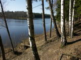 |
Lake Valgums is 3 km long and 27 m
deep, and it dates back to the last Ice Age.
|
|


