
| No | Name | Description |
|---|---|---|
 |
Atrodas Vārtājas ielejas labajā krastā un labi saskatāms no Priekules – Grobiņas (P106) ceļa. Senās kuršu zemes – Piemares pilskalns, kas vēstures avotos pirmo reizi minēts 1253. gadā – līgumā starp Kurzemes bīskapu un Livonijas ordeni. Viens no lielākajiem Dienvidkurzemes pilskalniem. Iespējams, ka iepriekš – arī sens kulta kalns. Pagājušā gadsimta sešdesmitajos gados veiktajos arheoloģiskajos izrakumos konstatēts, ka pilskalns bijis apdzīvots jau vidējā dzelzs laikmetā. Pie tā konstatēta liela senspilsētas vieta. |
|
 |
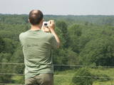
This is a lovely place in Sigulda which has been painted (as the word "gleznotāji", which means "painters" suggests) and photographed for centuries. This is basically not a hill at all, it's just the place where the shore of the ancient Gauja River valley is split by the mighty Vējupīte ravine. You will have an excellent view of the Turaida Castle and the river valley. There are leisure facilities and a viewing platform there. You can ride to Paradīze hill via an electric car. |
|
 |
The former air defence missile base took up a large territory to the South of Pāvilosta in its day, but today that land has been abandoned and degraded. It can be dangerous for visitors.
|
|
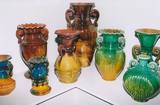 |
This museum is devoted to the career of the ceramist Polikarps Čerņavskis. His work featured light, yellowish and very bright glazing. Guided tours of the museum are available. There are demonstrations of the use of the potter’s wheel. Ceramics can be purchased, and visitors can attend the opening of the kiln. Special works can be commissioned.
|
|
 |
1275 is considered as a year of foundation of Daugavpils. This is the time when the Master of Livonian Order Ernst von Ratceburgs built Dinaburg castle at the Naujene hill fort. It suffered several Lithuanian and Russian invasion until in 1577 the castle was destroyed by Russian troops under the command of Ivan the Terrible. After this event Dinaburg was restored 17 km further on the right bank of the river, where now the town of Daugavpils is located. From 1810-1833a new fortress was built. In 1826 started the building of what is now the historic centre of the town. During the World War I the major industrial companies with workers were evacuated to Russia. During first Latvian Republic, the cultural life in Daugavpils flourished. Most part of the town was destroyed during World War II – in the July of 1944. Nowadays the town is the second largest town in Latvia and is an important economical centre of Latgale historic region. Restoration of Daugavpils Fortress was launched recently; this project can be considered as a unique on the European scale. |
|
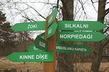 |
is seen as the newest village along the Livonian coastline. It was established during the 17th century. Košrags had 78 residents in 1826. The first reading school for Livonian children in the Dundaga seashore villages was opened at the Žoki homestead in 1832. One of the teachers was Nika Polmanis, who was the first Livonian to have completed a professional education. He also translated the Gospel of Matthew into the Eastern Livonian dialect. Košrags had a windmill, water mill and boat building facility. During the spring, job seekers from Saaremaa stopped here. A port was installed in 1932, and a breakwater to collect sea fertiliser followed in 1938. During the 1930s, Košrags was regularly visited by Finnish and Estonian linguists to study the folklore of the Livonians. The Norpiedagi homestead was built by Livonian activist Didriķis Volganskis (1884-1968). His son, Livonian cultural worker and pastor (in Finland) Edgars Vālgamā (Volganskis, 1912-2003) was born there. He translated the Andrejs Pumpurs epic "Lāčplēsis" into Finnish. Košrags today is a cultural monument of national importance. |
|
 |
The Karosta prison cannot be described, it must be experienced and survived. That’s an opportunity for everyone. This is the best example in Latvia as to how the military heritage can be used for tourism purposes. Others can learn from this site. |
|
 |
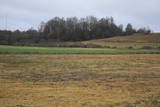
Open landscape area within farming lands on both banks of Uzava River about 10 km before it flows into the Baltic Sea. There is a good open view over the area from the Vendzava-Ziri road going through the nature park. Protection of migratory birds and corncrakes has been one of the main reasons for establishment of the nature park. Bird watching is possible from the road Vendzava-Ziri during migration period in spring and fall. There is no tourist infrastructure in the nature park.
|
|
 |
Organising workshops for Udmurts and other Finno-Ugric national cuisines, learning the culture of other people through food. |
|
 3 days
|
This part of the Forest Trail gives an opportunity to see Setomaa or “the Land of Setos” which is inhabited by Setos – an ethnographic group with specific ancient traditions and a unique language dialect. Forest Trail hikers can visit the traditional Setos homestead and enjoy Setos cuisine. The forests of the region are especially charming in early autumn, when the ground is coloured lilac by the blooming heather. There is a good chance to pick wild mushrooms and berries. One of the most beautiful sections of this trail in Setomaa leads along the River Piusa, where the river is surrounded by sandstone outcrops. You will also visit the Piusa caves. The tour will end in Värska resort – with its sanatorium and SPA, which use the strengths of local nature: mineral water and lake mud. Värska mineral water is well known in Estonia and elsewhere. |
|
 |
Karņicka kalns pēc savas izcelsmes nav kalns, bet gan Daugavas ielejas nogāzes daļa ar labu skatu uz Krāslavas mazstāvu koka apbūvi. Ar šo vietu saistīts traģisks nostāsts par poļu virsnieka Josifa Karņicka un grāfa Plātera meitas mīlestību, kurai nebija lemts piepildīties tā laika „paražu” dēļ. Tā rezultātā abi nelaimīgie nolemj izdarīt pašnāvību. Virsnieks nošaujas, bet Emīliju pēdējā brīdī izglābj kalpone, neļaujot tai izlēkt pa pils logu. J. Karņicka pašnāvības vietā ir uzstādīts piemineklis. Nedaudz tālāk – rietumu virzienā guļ t.s. Austriņa akmens, pie kura 1909. gadā iedvesmojies un radījis latviešu rakstnieks Antons Austriņš. |
|
 |
The company runs wildlife tours: rafting in early spring, kayaking in summer (with beaver watching upon request), bog and snowshoeing round the year, kick-sledging in winter. Our experienced guides tell exciting stories of wildlife and history. |
|
 |
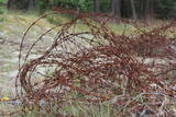
The forests of Zvārde are located on land which used to be a Soviet air base. The territory was unpopulated and was not accessible to civilians. The vast area includes various types of forest - boreal forest, bogs of black alder, etc. The fact that the military used to control the territory is one of the reasons why the forests of Zvārde are a location where many rare and protected birds live, reproduce and find food. Some of the elements of the old air base are still in place, including a unique surveillance platform. It is recommended that visitors to the area drive only along general use roads. |
|
 |
Brīvdienu māja "Jasmīnu nams" atrodas pie pašas Jelgavas robežas - tikai 7 minūšu braucienā līdz pilsētas centram. Brīvdienu māja ir lieliska vieta mierpilnam dabas baudījumam, kas rit roku rokā ar iespēju stiprināt veselību pirtī vai alternatīvā SPA - āra kublā. Brīvdienu mājā ir 3 istabas, savrupa teritorija vienai līdz divām mājsaimniecībām – līdz 6 personām, īpašu uzsvaru liekot uz atpūtu kopā ar bērniem. Nav paredzēts skaļām ballītēm un jauniešu tusiņiem. Namiņā ir viss nepieciešamais maltītes pagatavošanai gan iekšā, gan ārā svaigā gaisā. Tuvumā atrodas Svētes upe un atpūtas zona - Svētes palienes pļavu koka laipu celiņu tīkls. |
|
 |
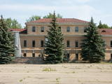
The air defence radar facilities at the Liepāja airport in Cimdenieki are gone now, although the man-made terrain in the area remains interesting today.
|
|
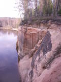 |
These sandstone cliffs were once known as the Pieškalni or Pieškaļi cliffs. They are around 7 km to the North from the centre of Cēsis. These are the most monolithic sandstone cliffs in the Baltic States – around 700 m long (with some 330 m along the Gauja River) and a maximum height of 22 m. There is a viewing area which offers a grand view of the Gauja River valley. Water tourists will boat up to the majestic wall of the cliff and will be surprised at what they see! The name of the cliffs, Ērģeles, is the word for "pipe organ" in Latvian, and the name was supposedly given to the cliffs because of the echoes which can be heard there – they reputedly sound like an organ. Hikers and boaters must be very careful when in this area – please make sure that you are safe! Please note, too, that the infrastructure of the cliff is scheduled to be renovated in 2012. |
|
 |
This is actually a group of nine craters, and some of them are as much as 100 m in diameter and 16 m in depth. This is the most visually expressive meteorite crater in the Baltic States and, indeed, in all of Europe. Remnants of the meteorite – some 2.5 kg in all – yielded iron and nickel. It is thought that this pan-Baltic natural catastrophe occurred 2,600 to 4,000 years ago. Kaali Visitor Centre comprises the meteoritics and limestone museum, a conference hall and a hotel.The museum exhibits genuine meteorite pieces amongst other items. The hotel has all modern conveniences, tasty food is provided at Kaali Tavern nearby. |
|
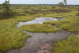 |
Very wide territory for a nature restricted area where extensive forests and several bogs can be found. The territory is important living space for many bird species. Vasenieku bog path with observation tower is the most attractive sites of the restricted area and offers unique landscape of the bog for its visitors. Waterproof shoes are recommended for visitors as the first 500 m of the path is molded turf rampart. Information stands are significant source of information along the path. It is suggested to visit also Stikli (Glass) village where glass factory used to be. Chandelier of Stende church has been made in this factory (by memory of Inese Roze).
|
|
 |
The coast guard facility is not used at this time. Still there is a monument, a border post, and lavatories with wooden toilet paper holders. A good view of the facility can be seen from the high barrier along its southern edge.
|
|
 |
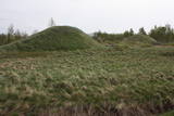
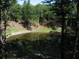
Īdeņa Castle mound is located near Lake Lubāns. A beautiful view
to the lake and to the marshy meadows. The place was inhabited from
the 11th century.
|
|


