
| No | Name | Description |
|---|---|---|
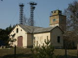 |
The Cape of Kolka is freely accessible to local residents and tourists today, but the border guard facility still serves its purposes and is not open to civilians.
|
|
 3 days
|
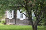
This tour will take you exploring the peculiar island of Rusnė and the delta of the river Nemunas in Lithuania. The island of Rusnė in the Nemunas Delta Regional Park is enclosed by waters of the river Nemunas and its tributaries. It is a resting place for migratory birds and home to a cormorant colony. The area of the island is 45 km2 and it is connected to the mainland by a bridge. The island of Rusnė is the lowest place in Lithuania, lying below sea level. The historic centre of the town Rusnė is characteristic of authentic wooden architecture, buildings painted in bright colours, colourful window shutters and decorations. The Baltic Coastal Hiking Route leads through the small town of Šilutė, revealing architecture that was once common to East Prussia. From Šilutė to Kintai, the Baltic Coastal Hiking Route runs along a low plain. To protect this area from flood waters of Nemunas, there is a system of dams, polders and canals established. After crossing the river Minija, the route invites you to visit the ethnographic village of Minija. Here you can enjoy the lowland landscape of the seaside region with vast wetlands and ponds. |
|
 |
The rock is along the main street of Krāslava and is found at Augusta Street 12. After major reconstruction of the city’s infrastructure, the rock was successfully integrated into the surrounding landscape. The rock is 2.8 m long, 2.2 m wide and 700 cm high. It once served as a border stone for the village of Krāslava. It was placed there in 1729 to commemorate the day when the noble Plater dynasty bought Krāslava. The dynasty’s seal is engraved in the side of the rock along with the date when it was installed. Legend has it that Polish King Augustus II dined at the rock after a hunt, and that is why it is known as Augustus’ Rock. |
|
 |
Together with Valga on Estonian side - a peculiar frontier twin town. |
|
|
|
Starp steķiem un Tūjas ķieģeļu fabriku bija
izveidots sliežu ceļš, pa kuru transportēja labākās kvalitātes ķieģeļus.
Pēckara gados „Dzeņu” krastā uzcēla zivju pārstrādes rūpnīcu, bet pāri
steķiem – cauruli, pa kuru ar ventilatora palīdzību sūknēja zivis no kuģiem,
kas bija piestājuši steķu galā.
|
|
 |
Eine der ältesten Ortschaften Litauens. Schon im 14. Jh befand sich hier eine Holzburg. Der 20 m hohe Merķine-Burgberg an der Mündung der Flüsse Merkys und Nemunas. |
|
|
|
One of the three highlands of Southern Estonia with scenic hills and beautiful sights. In its center lies the bay-rich Lake Pühajärv (translating from Estonian - Holy Lake). |
|
 |
Vieta, bez kuras apmeklējuma nav iedomājama Dzūkijas vēstures un kultūras izziņa! Muzejs meklējams Marcinkones centrā, netālu no dzelzceļa stacijas. To noteikti ir jāiepazīst vietējā gida pavadībā, kas pastāstīs daudz interesantus faktus par dzūku tradīcijām un attiecībām ar mežu. Muzejā ir apskatāma dzīvojamā ēka ar ikdienas sadzīves priekšmetiem un rija, kas pārsteidz ne tikai ar savu plašumu, bet arī vairākiem interesantiem eksponātiem, no kuriem ir jāpiemin milzīgs sēņu grozs (tajā iegāja 110 kg gaileņu!), 750 gadus veca vienkoča paliekas, bitenieku un vietējo amatnieku instrumenti u.c. Rijā notiek ikgadēji ar dzūku kultūru un vēsturi saistīti pasākumi. Visbeidzot, te var iegādāties vietējos suvenīrus un medu. Ja ir vēlme iepazīt Marcinkones tuvāko apkaimi, ar kājām var doties pa 13 km garo Zackagira dabas taku (Zackagirio gamtinis takas). |
|
 |
The memorial to the day when people in the Baltic States joined hands in an unbroken chain stretching from Tallinn through Rīga and on to Vilnius on August 23, 1989, is at the 25th kilometre of the Rīga-Bauska highway, near the little Ķekaviņa River. |
|
 |
This park covers the Nemuna River valley between the villages of Seredžius and Geldaudišķis, with lovely views of castle hills, medieval castles, aristocratic estates, etc., along the shores.
|
|
 2 days
|
The legendary blue hills of Šlītere have been known since ancient days, when pirates lit false campfires that led ships to run aground near Cape Kolka. The shoreline in the Slītere National Park is known as the open-air geological museum of the Baltic Sea, because the ancient shores of the Baltic ice sea, Lake Ancylus, and dunes from Littorina Sea can be seen here. These offer a fine view of the history of the Baltic Sea. The territory was historically populated by the Liv people, and their fishing villages are a cultural environment of one of the smallest ethnic minorities in the world. The route between Kolka and Mazirbe goes down the old shore road that passes through Liv villages. The Slītere National Park has one of the greatest amounts of plants in Latvia, while Cape Kolka is one of the country’s most popular bird watching sites. Route information from Latvijas Lauku forums |
|
 |
The owners of Tahku coastal houses organise cucumber marinating and salting workshops with a happy mood. Cucumber festival Tahkuranna takes place every year on 20 August, and there you can buy canned cucumbers, local food and handicrafts, participate in master classes, and also make handicrafts. |
|
 3 days
|
The first half of this section leads through magnificent coniferous forests, especially in the Järvevälja landscape reserve, where the trail is surrounded by beautiful dunes in the north and a raised bog in the south. It is well worth visiting the kiosk at Rannapungerja to buy smoked fish – the Lake Peipus vendace (rääbis) and some local farm produce. In the second part, the Forest Trail winds along the coast of the beautiful Lake Peipus. During the summer, when the water level in the lake is lower, beautiful, sandy beaches with wide shallows appear. Past Alajõe, the highest dunes of Lake Peipus (up to 20 m) rise on the landscape, providing a distant view of Lake Peipus, one of the largest lakes in Europe. |
|
|
|
The town of Subate was first listed in documents in 1570, when Duke Gotthard Kettler of the Duchy of Courland sold the Subāte marketplace to Count G. Plater-Sieberg. When the Plater-Sieberg dynasty converted to Catholicism in the mid-17th century, Lutherans in Subate protested by moving to the eastern bank of Lake Subate. That was the property of the Prode Estate (only ruins remain at this time), which was owned by the Osten-Sacken dynasty. In 1685, the Osten-Sackens built a Lutheran church for the “refugees,” and Jaunsubate was established around it. Both parts of the town were merged again in 1894. During Latvia’s liberation battles in 1919, Subate was liberated by Lithuanians, at which time the town was divided up between Latvia and Lithuania (though the border between the two countries was set at the previous line in 1921). The historical centre of Subate was established between the 16th and the 19th century, and it includes four churches for various congregations and low wooden buildings which stretch along narrow and curvy streets. The town is on the shores of a sub-glacial depression with Great Lake Subate and Lesser Lake Subate therein. This provides the town with unusual landscapes for Latvia. |
|
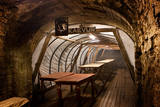 |
The most fascinating part of the Park is its underground museum. Guided underground tours take visitors to where miners used to work and rest and stored their explosives, and include a real train ride and learning about various pieces of equipment and technology. A delicious miner’s lunch can be booked in advance and enjoyed in a genuine miners´ underground canteen. |
|
 |
Apmeklētājiem tiek piedāvāta ekskursija ar stāstiem par Limbažiem, kas kādā veidā saistīti ar sudrabu. Ekskursijas laikā iespējams apskatīt paraugdemonstrējumus lodēšanā. Sadarbībā ar juvelieriem, darbnīcā būs iespējas apgūt prasmes darbam ar misiņu un sudrabu, tiks piedāvātas arī meistarklases. Pēc iepriekšējas pieteikšanās grupām būs pieejamas arī O.Auzera lekcijas par sudraba ietekmi uz veselību. Ekspozīcija atvērta apmeklētājiem no trešdienas līdz svētdienai no pl.10:00-17:00, citā laikā grupām- pēc iepriekšēja pieteikuma. Ieejas maksa: |
|
 |
The botanic garden is part of the Siauliai University and is the newest and smallest botanical garden in Lithuania, covering 6.54 ha of land. |
|
 |
Tihuse farm on Muhu Island is engaged in horse breeding; this place also offers authentic food and a special menu for people with various food intolerances. It is very popular to take a horse ride, followed by a picnic. Lentil cakes are our special treat. |
|
|
|
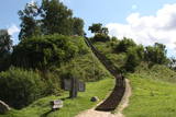
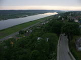
The viewing tower is on the western part of the Blue Hills of Ogre, not far from the Dubkalni quarry. Paths lead to the tower, as does a wooden staircase. The viewing platform offers a very broad view of the Ķegums hydroelectric power plant reservoir and the towers of
|
|
 |
Saimniecība "Baltiņi" atrodas Auces novadā un nodarbojas ar lopkopību un lauksaimniecību. Viesiem ir iespēja redzēt un izzināt piena ražošanas procesu, kā arī iepazīt saimniecības dzīvniekus. Saimnieki piedāvā apskatīt padomju laiku auto kolekciju, pieejama arī suvenīru un trauku kolekcija ar govs motīviem. |
|


