
| No | Name | Description |
|---|---|---|
 |
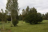
Laila Kelle works in a building of the former Lamiņi semi-estate. She teaches drawing and painting of landscapes and still life paintings, using oil paints for this purpose. Nature trail (3km).
|
|
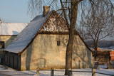 |
This little building is on the left bank of the Venta River beyond the ancient brick bridge. It is located at Pils Street 4. The hut was built in 1735, using rocks from the damaged castle of the duke, and it was built on a terrace that is the last fragment of the walls that surrounded the castle. Also known as the Hangman’s hut, the building was rebuilt during the 19th century. It can only be viewed from the outside. |
|
 |
Druvienas muižas pirmsākumi ir meklējami 17. gs. beigās. Tagad redzamā apbūve ir veidojusies 19. – 20. gs. Līdz mūsdienām ir saglabājusies muižas pils (1898. g.) un saimniecības ēkas – klētis, kūtis, kalpu mājas. Muižas pilī 20. gs. 50. gados izvietoja pamatskolu. Diemžēl sākotnējie ēkas interjeri nav saglabājušies. Pili ieskauj parks. Šobrīd ēkā atrodas Druvienas Latviskās dzīvesziņas centrs, kas piedāvā dažādas aktivitātes un radošās darbnīcas. |
|
 |
Summer cafe "Divjurinas" is located at Kolkasrags, open from May to October. |
|
 |
This labyrinth covers 3,300 m2. Visitors can make their way through the maze, trying to find the exit and handling clever tasks at some of the special twists and turns in the labyrinth. There is a playground for children, along with a workshop, a mud café and the “fir tree village.” |
|
 |
Ein von der Bildhauerin Solveiga Vasiļeva 2003 errichtetes Gedenkzeichen „Gottesohr” für Staburags befindet sich im Park von Vīgante am Platz, wo nach der Errichtung des Stausees des Wasserkraftwerkes von Pļaviņi eins der interessantesten geologischen Naturdenkmäler Lettlands unter Wasser gesetzt wurde. Staburags war ein von Sagen, Legenden und Erzählungen der Flößer umwobener 18,5 m hoher Kalksteinfelsen am linken Ufer des Daugava-Kanjons, das nach der letzten Eisperiode gebildet wurde. Aus dem Felsen floss die Quelle Liepavots, die auch unter Wasser gesetzt wurde. Der Felsen Staburags und das versunkene Daugava-Kanjon waren einige der populärsten touristischen Objekte Lettlands. |
|
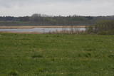 |
Nature restricted area surrounds Tasu Lake and swampy shores of it in a narrow band. The territory was established to protect rare nesting and migratory birds. The territory is easily overseen from the narrow gravel roads all around the area not entering the actual protected area. Tasu Manor house is located to the South of nature restricted area.
|
|
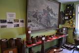 |
Das Museum wurde 2007 eröffnet. In der Exposition sind ein 180 mm Kanonenrohr, Rekonstruktion der Staatsgrenze, Zivilschutzräume, Panzerwagen, Grenzüberwachungsboot, Meeresminen. Im Hauptgebäude wird Beobachtungsradar, Waffenabstellraum, Kasernenmilieu und andere thematische Gegenstände präsentiert. |
|
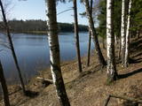 |
Der Valguma See – der bis zu 3 km lange
und 27 m tiefe See hat sich in einer
subglazialen Rinne gebildet.
|
|
 |
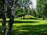
Work on the arboretum, which covers 15 hectares of land, began in 1968, and it was meant to be a landscape park. The first plants were planted in 1972. During the fierce winter of 1976, sadly, many of the plants froze. In 1987, the park was redesigned. At that time it had 234 types of deciduous trees, coniferous trees and bushes. There are signs showing the Latin and Latvian names of the various plants
|
|
 |
Brīvdienu mājas "Korķi” apkārtnes priežu mežā ir izveidota Jāņtarpiņu taka. Ideāla vieta aktīviem sēnotājiem un ogotājiem. Savukārt saules un jūras cienītāji pa šo taku 5-10 minūšu gājienā nonāks Vitrupes pludmalē, kur varēs baudīt sauļošanās un peldēšanās priekus.
|
|
.JPG?size=160) |
Gegründet für den Schutz des reichtesten historischen Erben der Umgebung Trakai, der Kulturlandschaften, des Galvė-Sees (auf dem See befindet sich die Seeburg Trakai) u.a. |
|
 |
Die Schänke befindet sich am Rande der Straße Murjani – Limbazi (P9). Sie ist auf den Fundamenten der Mühle des Landgutes gebaut worden, dabei wurde das Mühlenrad erhalten. Die Schänke arbeitet mit den lokalen Bauern zusammen. Lettische Küche: Steinpilzsuppe, Gerstengrütze mit Fleisch, Gerstenfladen, Grützwurst mit Preiselbeersoße, dünne Pfannkuchen mit Marmelade, Kartoffelpfannkuchen, gebratene Flunder oder gebratener Zander, geschichtetes Roggenbrot-Dessert. Das besondere Gericht: Geschmortes Kaninchen und gefülltes Truthahnfilet. |
|
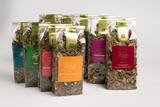 |
In the farm "Ozoliņi" organic tea is produced. With brand "Lauku tējas" tea has been sold in stores more than 17 years. Hostess is happy to share her knowledge through seminars and tea workshops. The farm is surrounded by forests and biologically valuable meadows where you can find up to 50 plants per square meter. |
|
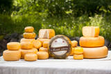 |
The Vecsiljāņi farm is in the Bebri Parish in the Koknese Administrative District. It is a dairy farm and also grows wheat, barley, oats, rye, corn and grasses. In 2010 the farm began to produce hard cheese under the brand name "Ievas siers." Visitors can taste the cheese and tour the farm and the cheese-making facility. |
|
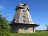 |
The owners have maintained a historical windmill (built in 1885) and its mechanisms. You can go on a tour of the structure, look at the mechanisms of the mill and taste local baked goods and country bread. |
|
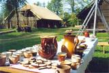 |
This is the farm of a moderately wealthy Selonian farmer from the 19th century. It features a residential building with a mantel chimney, two granaries, a threshing barn, a sauna, a windmill, a smithy, a steam locomotive and a threshing machine. Groups will enjoy thematic programmes such as “Crafts at the Selonian Farm,” “When Honey Melts on Your Tongue,” and “A Wedding at the Selonian Farm.” |
|
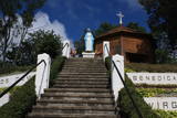 |
Находится в 50 м к западу от Лудзенской католической церкви. Построена в 1738 году в форме восьмиугольной ротонды и служила местом отдыха графов Карницких. Небольшое здание с дощатой обшивкой, деревянным потолком и кирпичным полом. Возле капеллы установлена скульптура Девы Марии (1934 г.) работы лудзенского художника Леона Томашицкого - королевы земли Мары. |
|
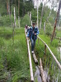 |
Ap 7 km garš lokveida pārgājienu maršruts (marķēts), kas ved pa dažādiem biotopiem – mežiem, mitrājiem un pļavām, mezdams līkumus pa stāvo pauguru nogāzēm. Takas malās ir izvietoti informācijas stendi un norādes. Rebases ainavu taka ir domāta tiem, kurus nebaida garāka iešana un orientēšanās pa ļoti dabisku un mazapdzīvotu apvidu. |
|
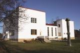 |
The Liv People’s Centre – a building erected in 1939 which represents the identity
of the Liv people and houses a photographic exhibition devoted to the Liv people.
|
|


