
| No | Name | Description |
|---|---|---|
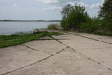 |
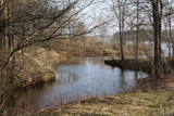
The hydroplane airfield is on the eastern shore of Lake Durbe, not far from Līguti. It was built between 1939 and 1941. During the Soviet era, the 43rd aviation escadrille was located here, and it had 13 MBR-2 hydroplanes. All that’s left today are the cement sheets on the shore of the lake. You can look at the site itself.
|
|
 |
The first Dnyestr-M radar station was opened here in 1969 to calculate the trajectories of ballistic missiles. The trajectories of satellites were also calculated here. The range of the radar station was 5,000 km. In 1972, construction began on a second, more modern radar, the Dnyepr-M. In 1977, it was ready for use, and the first radar was modernised at the same time. The two radars were located in buildings that were 250 m long and 17 m high. During a 24/hour period, they could identify the height, speed and flight trajectory of up to 750 space objects. In 1985, work began on a third, even more modern radar – the Daryal-YM. This was a radar that could “peek” across the horizon. The antenna building was 117 m high (19 stories), 80 m long and 80 m wide. It had a planned range of 6,000 km, but it was not completed. After the withdrawal of the Russian army in 1995, the building was blown up. That cost LVL 6,172,311 and used up 360 kg of explosives. The territory of the radar stations took up 1,072 hectares, with barracks, a hotel, 551 apartments, a medical facility, a water tower, a war hospital, a bomb shelter, etc. The aim of the facility was to monitor space above Western Europe and North America, as well as to “intercept” any ballistic missiles that were fired at the USSR. The territory is closed to visitors, but it is an important part of Latvia’s military heritage. The abandoned territory can be viewed from the outside. The nearby bus stop is called “Kombināts.” This was the only facility of its kind in the Baltic States. !!! Since March 2018 the Skrunda army base is closed for visitors. |
|
 |
The Karaosta canal and its naval and submarine base date back to the tsarist era in advance of World War I. The former submarine base is now closed to visitors and is used for business purposes. The canal can be viewed from Pulvera Street and the restored Kalpaks bridge.
|
|
 |
The projector buildings of the former border guard facility have been preserved at Labrags, but they are privately owned.
|
|
 |
A memorial to Finnish soldiers in
Klapkalnciems – five such soldiers from
World War I are buried here. The memorial
was first installed in 1929, but it was
destroyed by the Soviet authorities. It was
recreated in May 2004. The Lapmežciems
Museum features photographs and more
information about the Finnish soldiers.
|
|
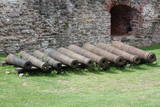 |
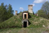
The Bauska Castle contains a collection of cast iron cannons which date back to the latter half of the 17th century and the beginning of the 18th century. They were manufactured in the Duchy of Courland. The cannons that are in the garden of the castle were not found there – they were found in different locations in Zemgale. Four of the largest cannons came from Jaunsvirlauka, where they were found on the banks of the Lielupe River opposite Emburga. They are the best preserved weapons of their type in Latvia. The only cannon that was found in the castle itself is currently in its South-eastern tower as a thematic exhibit. When it was being cleaned, two cannonballs were found in the weapons. The local Livonian Order castle is in ruins, but it and its defensive structures, including earthen ramparts that were installed from the mid-15th until the early 18th century, represent an important element of Latvia’s military heritage.
|
|
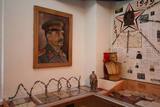 |
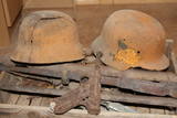
The local museum offers an interesting and extensive exhibit related to World War II at the Kurzeme fortress and the fate of Latvian soldiers who took part in the war. There are also exhibits related to the history of World War I and World War II, complete with a collection of civilian and military objects. Among them – a YI-2 airplane, an armoured personnel carrier, a Red Army tank, and all of the trenches and bunkers of the relevant era.
|
|
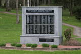 |
Late in September 1944, during World War II, the village of More was witness to some of the bloodiest and most merciless battles in Latvia – only those in the so-called “cauldron of Kurzeme” were worse. Members of the Latvian Legion who were fighting on the German side prevented the ability of the Red Army to break through to Rīga, and they also prevented the encirclement of the German military force. The result of the battle was enormously important to the more than 100,000 civilians who took the opportunity to become refugees and escape the Soviet repressions that were not far in the future. Commemorative events are held in the park each September, bringing together eyewitnesses to the battles and other. There’s a memorial wall with the engraved names of members of the Latvian Legion whose names are known, as well as a stone cross to commemorate unknown soldiers. Two kilometres to the East of the park is a museum, outside which is a Soviet army tank.
|
|
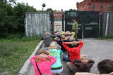 |
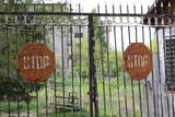
The Karosta prison cannot be described, it must be experienced and survived. That’s an opportunity for everyone. This is the best example in Latvia as to how the military heritage can be used for tourism purposes. Others can learn from this site. |
|
 |
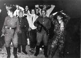
In 1944, between November 14 and December 9, there were fierce battles between SD and SS units from the German 16th Army, under the command of Police General Friedrich Jekeln, and a separate battalion of the Kurelians, under the command of Lt Roberts Rubenis. The battles were waged in the Ugāle, Usma, Renda and Zlēki parishes. Rubenis’ men were well-armed and organised. There were more than 600 troops, and the soldiers saw themselves as a national force which stood apart from the two hostile occupant regimes. This was the longest and most extensive battle in the history of Latvian national resistance. As the military force of the Latvian Central Council, the unit enjoyed extensive public support and confirmed a high level of morality in fighting for the restoration of a democratic Latvia. (The preceding text comes from the Rubenis Fund.)
|
|
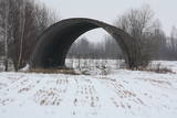 |
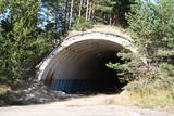
Few Soviet military objects are associated with more legends than this one. During Soviet times, this was a reserve airfield, as well as a storage site (just 50 kilometres from the republic’s capital city) for nuclear weapons. These were hidden in two cement hangars that were covered with soil and vegetation. Public information suggests that an RX-24 nuclear bomb weighing 430 kg and a RX-26 nuclear bomb weighing 1,030 kg were stored here, as were air-to-land missiles equipped with nuclear explosives. If there had been an accident here, what would have happened to Rīga, to Latvia, to the Baltic States and to Northern Europe? The airfield is a closed territory today.
|
|
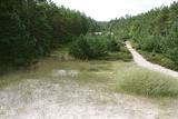 |
A shooting range which isn’t really there anymore, but it was once
used for training purposes by the Soviet military. Right now you will see
an overgrown area of land which stretches from the seashore to the
Kolka-Ventspils road. That’s where the shooting range was located.
|
|
 |
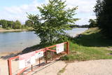
In the small town of Pļaviņas, at the place where the Skanstupīte River flows into the Daugava (Friendship Park), there are the remnants of a set of small and low fortifications known as the Swedish bastions. This was a place of military and political importance, because here was the place where the boundaries of Vidzeme (under Swedish rule), Latgale (under Polish rule), and the Duchy of Kurzeme (on the opposite side of the river) all came together. In 1625, the Swedes were defeated by the Poles here, and Swedish King Gustav Adolf almost lost his life. Medieval bastions of this kind can be seen in some other places of Latvia, as well.
|
|
 |
Liepene, in the Ventspils District, was once home to a coast guard division. The facilities are now privately owned and offer accommodations to tourists.
|
|
 |
This was at one time an important element in the protection of Soviet Latvia’s shoreline. A visually interesting and impressive territory near the seashore, it has sadly not been properly managed and is thus full of trash.
|
|
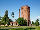 |
Encircled by apartment buildings, some of which are abandoned, the Tosmare water tower, which was built in 1905 in a pseudo-Gothic style and is made of red bricks, stands tall and proud. It is 37 metres high. Steam pumps were once used to pump underground water into the tower (the pumps have survived to this very day). Water was delivered three times a day to the residents of Karosta. The tower is no longer used for its original purpose, however. The tower can be viewed from the outside at any time. This is a unique aspect of Latvia’s industrial heritage.
|
|
 |
The Soviet Border Guard arrived at Lapmežciems (its border with Ragaciems) in the mid-1960s and left in 1991. Some 50 military personnel were stationed here. The military personnel and local residents organised various events and celebrations. The only thing that worried locals was a radar which was said to cause various problems. The zenith missiles were dismantled and taken away in 1991. An apartment building is still on what was then the military base. |
|
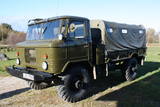 |
Edgars Kārklevalks, operator of a guesthouse Pūpoli, has a restored Soviet military GAZ-66 truck in which he offers historical and informational tours of Northern Kurzeme. The route includes former military territories.
|
|
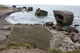 |
This is one of the most visually expressive coastal defence batteries in Latvia. Why? Because most it has been fully or at least partly washed into the sea, creating a truly unusual landscape, particularly during stormy weather. This is an historical monument which is subject to the mighty power of Mother Nature. The battery can also be seen from the Northern breakwater of Liepāja. It’s worth hiking the four kilometres along the beach to the Northern Forts. Along the way, you can take a look at the No. 23 Coastal Defence Battery.
|
|
 |
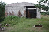
The former Soviet communications division at Plāņciems in the forests of Bārta is privately owned and is being dismantled at this time.
|
|
