
| No | Name | Description |
|---|---|---|
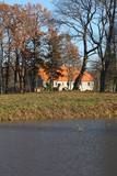 |
The residential building was erected in the early 18th and renovated in the middle of the 19th century. Restoration of the manse and its ancillary buildings is continuing even today. Since September 2009, the Latvian Evangelical Lutheran Church has housed its Recollection Centre at the manse. The ruins of an old stable can be seen. |
|
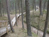 |
The nature park in the city of Jūrmala was set up to protect dune, pine forest and shoreline habitats. This park features one of the most attractive nature trails in the Rīga area, and it is found near the famous Ragakāpa dune, which can be as much as 17 metres high. This is an excellent opportunity to study dune habitats and the plants, birds, insects, etc., which live there. Visitors can also see pine trees that are 100 years old and older. |
|
 |
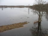
The tower on the eastern shore of Lake Engure (next to the meadow for wild cattle, accessible from the side of Bērzciems) offers a view of the reeds, small islands, Great Island, cows and horses of the north-eastern part of the lake. The tower on the northern shore of the lake (accessible from the side of Mērsrags) offers a look at the boating facility and the very overgrown northern part of the lake. The tower at the north-western shore of the lake (accessible from the side of Ķūļciems) shows the Apaļrova island (a footpath), stands of juniper, the boating facility, and the mosaic-like landscape of the lake itself.
|
|
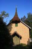 |
Atrodas Labraga – Apriķu ceļa malā. Kāds nostāsts vēsta, ka to 1896. gadā cēlis vietējais muižkungs, kurš vēlējies, lai viņa meitas laulības notiktu baznīcā. Dievnamā atrodas altārglezna "Kristus pie krusta un Sv. Marija Magdalēna", kas gleznota 19. gadsimtā (autors T. Šprengels). |
|
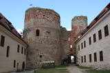 |
Bauska's name in historical sources for the first time is mentioned in 1443. This is the time when on the peninsula between Musa and Memel confluence construction of last Livonian Order castle on the present-day territory of Latvia was begun. At the castle – in Ķirbaksalā populated area so-called Vairogmiests developed. During the 17th century rapid boom of the town was observed. Here were working goldsmiths, silversmiths, carpenters, potters, shoemakers and other craftsmen. In later centuries the city suffered from wars, plague and Napoleon army. Today Bauska old town with reconstructed City Hall and the restored Bauska Castle is one of the most interesting Latvian historical town centres. Bauska is known for its annual events - Ancient Music Festival, Bauska town festival, country music festivals, and other events. |
|
 |
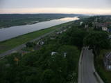
The Dole is the largest island in the Daugava River, surrounded to the Northeast by the rapid waters of the Daugava and to the Southwest by calm and gradually overgrown waters from Dry Daugava. The island is a specially protected nature park, established in 1986 to protect the landscape and cultural and historical values of the island in the wake of the construction of the Rīga hydroelectric power plant, as well as rare and protected species of plants and animals. The island is also meant to provide education and leisure for visitors. Best known on the island is the Daugava Museum, which is in the mansion of the old Dole Estate. The museum features some 13,000 exhibits that speak to the history of the island and the river – Baltic and Livonian apparel, tools and household objects. The exhibition also presents the Daugava as an important waterway and the related history of forms of transport and rafters. In the park is an open-air exhibition with reconstructed lamprey eel traps and a barrier to fish salmon, along with a set of fishing tools. A dolomite cliff is alongside the museum on the steep shore of the Dry Daugava. The ruins of the Vecdole castle can be found on the south-eastern end of the island, near Bēči. |
|
 |
Muižas pils (no sarkaniem ķieģeļiem celta) ir meklējama ceļu krustojumā pie Gaujām – 2 km ziemeļaustrumos no Jaunpiebalgas centra, Gaujas labajā krastā. Līdz 1918. g. muižas īpašnieki bija slaveno grāfu Šeremetjevu dzimta. Muižas pili nodedzināja 1905. g. nemieros, bet vēlāk atjaunoja. Muižas pilī bijušas dažādas iestādes: slimnīca, kolhoza „Piebalga” administrācija, mūsdienās – pašvaldība un dažādu sadzīves pakalpojumu sniedzēji. |
|
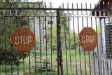 |
The first Dnyestr-M radar station was opened here in 1969 to calculate the trajectories of ballistic missiles. The trajectories of satellites were also calculated here. The range of the radar station was 5,000 km. In 1972, construction began on a second, more modern radar, the Dnyepr-M. In 1977, it was ready for use, and the first radar was modernised at the same time. The two radars were located in buildings that were 250 m long and 17 m high. During a 24/hour period, they could identify the height, speed and flight trajectory of up to 750 space objects. In 1985, work began on a third, even more modern radar – the Daryal-YM. This was a radar that could “peek” across the horizon. The antenna building was 117 m high (19 stories), 80 m long and 80 m wide. It had a planned range of 6,000 km, but it was not completed. After the withdrawal of the Russian army in 1995, the building was blown up. That cost LVL 6,172,311 and used up 360 kg of explosives. The territory of the radar stations took up 1,072 hectares, with barracks, a hotel, 551 apartments, a medical facility, a water tower, a war hospital, a bomb shelter, etc. The aim of the facility was to monitor space above Western Europe and North America, as well as to “intercept” any ballistic missiles that were fired at the USSR. The territory is closed to visitors, but it is an important part of Latvia’s military heritage. The abandoned territory can be viewed from the outside. The nearby bus stop is called “Kombināts.” This was the only facility of its kind in the Baltic States. !!! Since March 2018 the Skrunda army base is closed for visitors. |
|
 10 days
|
The tour introduces modern day life in rural Finland, Estonia and Latvia and includes visits to small farms raising livestock and producing delicious foods, and to ethnographic villages preserving the traditional lifestyle in a contemporary environment. The tour also involves sites of historical and cultural interest. |
|
 5 days
|
This route involves unique views that have never been seen before in Latvia! The impressively steep shoreline of the Baltic Sea begins a few kilometres to the North of Pāvilosta and ends shortly before Ošvalki, stretching for nearly 20 kilometres in all. Its most impressive and unusual forms are seen between Strante and Ulmale. The entire route leads down the western boundary of the former Iron Curtain, because the Baltic Sea coastline was militarised during the Soviet era and unavailable to most people. Remnants of former military objects and old tank routes in the dunes can still be seen. The largest biotopes of grey dunes stretch for several kilometres around Ventspils and Užava. These are unusual landscapes that can seldom be seen elsewhere in Europe. You can walk more than 10 kilometres here and not see another soul. Route information from Latvijas Lauku forums |
|
 |
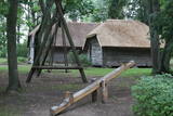
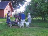
Zemnieku saimniecībā "Rudzīši" iespējams apskatīt dažādus mājputnus - vistas, tītarus, dažādu šķirņu pīles un zosis. Mini zoo mīt arī cūkas, aitas un kazas. Tiek piedāvāta izjāde ar poniju, kā arī iespēja pārnakšņot brīvdienu mājā. |
|
 |
Jēsū – Kepu ceļa malā pie Leti (Läti) ciema ir izveidots autostāvlaukums ar putnu vērošanas torni, no kura paveras skats uz Hallistes upes palieņu pļavām un tuvējā ciema apkārtni. Stipru palu laikā arī no šī torņa redzamā apkārtne (izņemot ceļus) var atrasties zem ūdens. Laba putnu vērošanas vieta. Läti tulkojumā no igauņu valodas nozīmē Latvija. |
|
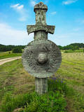 |
Embūtes dabas parks, saukts par Embūtes senleju, ir viena no skaistākajām, interesantākajām un noslēpumainākajām Kurzemes vietām. Nav Latvijā otras tādas vietas, kur ieejas vārtus dabas parka teritorijā simbolizē stilizēti zobeni ar vairogiem ceļa abās pusēs, radot mītisku un cienījamu noskaņu. Par Embūtes apkārtnes vēsturi stāsta daudzas teikas un leģendas. Viena no pazīstamākajām ir romantiskā teika par kuršu vadoņa Induļa un vācu komtura meitas Ārijas mīlestību. Vietā, kur viņi pirmoreiz tikušies joprojām atrodas Ārijas un Induļa ozoli. Embūtes dabā parkā ieteicams apskatīt - ekotūrisma taku, Embūtes viduslaiku pilsdrupas, Embūtes luterāņu baznīcas mūrus, Induļa pilskalnu, Pilskalna avotiņu, Induļa un Ārijas ozolu. Dabas parks aprīkots ar labiekārtotu pastaigu taku, skatu platformām, skatu torni, labierīcībām un atpūtas vietu. |
|
 |
This park covers the Nemuna River valley between the villages of Seredžius and Geldaudišķis, with lovely views of castle hills, medieval castles, aristocratic estates, etc., along the shores.
|
|
 |
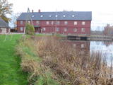
Zosna (Veczosna) Manor. The building is surrounded by a small park near the bank of Lake Rāzna.
There are 39 different species of trees and bushes. It was built in 1870 by the order of duke Goļicins. It is
one of the rare truss buildings in Latgale.
|
|
 |
Latgale Farmstead „Mežmalas”. The owners of the farmstead created an interesting collection of the old
household items, tools and equipment of the 19th and 20th century. The visitors are offered to try plainting of
the scale basket. Sale of baskets and herbal tea. Enjoy walking along the energetic path through the pine forest.
Working hours: on request |
|
 |
Interesanta dažāda vecuma ēku ieskauta gājēju ieliņa (gājēju daļa ~ puskilometrs), kura var novērot pilsētas arhitektūras stilu attīstību no 17. - 20. gs. Šeit tāpat kā citur Kuldīgā var apskatīt un nofotografēt pilsētai raksturīgos virsgaismas lodziņus un greznās un daudzveidīgās ēku durvis. Te vērts pasēdēt arī krodziņā! |
|
 |
The Vecročupe river flows out of the artificial Vaide pond. It was created by blocking the Vaide and the Kukšupe rivers. This happened during the Soviet occupation, when forestry people decided to establish a fishing pond and an area for recreations. A wooden pergola has been installed at the pond, and there is an information stand, as well. On the northern shore of the pond is the Vaide cemetery, which dates back to 1928 and has interesting wooden crosses. |
|
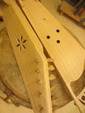 |
Andris Roze is one of very few kokle makers in Latvia who manufactures the instrument and helps others to do so at master’s classes. Roze also manufactures other traditional musical instruments, demonstrates them, offers consultations about them, collects them and gathers together historical information. He works at the Drabeši Crafts House, where people can learn traditional skills such as weaving, processing of leather, felting, pottery and construction of musical instruments. |
|
 |
The watermill processes wool with equipment that is 100 years old and is used to produce handmade blankets and pillows that are stuffed with sheep wool, as well as souvenirs that can be commissioned and purchased. The watermill offers tours and fresh-baked bread. A wool pulling and wrapping machine that dates back to the 19th century and was manufactured at the Šūberts Rudītis & Co company in the 19th century is still used, as are a unique weaving apparatus from Germany and a grain mill.
Latvian cuisine: Marinated herring with vegetables, porridge, mashed potatoes a la Vidzeme (with fried onions), pancakes with jam made of Latvian berries and honey, homemade bread.
Special foods: Water pretzels and local soup with six types of fish.
|
|


