
| No | Name | Description |
|---|---|---|
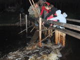 |
The owner offers groups of various sizes a chance to go to the sea in a fisherman’s boat and to watch shoreline fishing, as well. The lamprey eel weirs that are on the Svētupe River differ from those on the Salaca River in terms of their structure and the fishing principles. During the season, the owner prepares tasty smoked lamprey eels. |
|
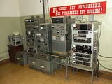 |
This extremely secret bunker was one of the most important facilities in Soviet Latvia in the event of a nuclear attack. Under the code name of “Rest Home,” the bunker is nine metres under the ground at the Līgatne Rehabilitation Centre, and it would have been the place where Soviet Latvian government officials would have gone in the event of an attack. The status of a secret object was lifted only in 2003. The underground installation has been preserved fully.
|
|
 |
The farmyard offers to see the domestic animals, birds and exotic maras as well as horse-back riding on a pony. You can get a consultation about gardening and breeding small animals. It is possible to buy quail eggs, smoked meats, chicken and birdlings. |
|
 3 days
|
This tour will take you on a walk through the Curonian Spit from Nida to Smiltynė. The Curonian Spit National Park is located on a long, sand-dune spit that separates the Curonian Lagoon from the Baltic Sea coast. A sand beach of ~50 km is running on the western side of the dune spit, while the shore of the Curonian Lagoon is shallow and characteristic of ridged bays overgrown with reeds. The Baltic Coastal Hiking Route starts in the centre of Nida near the port. In Nida, it runs along the Curonian Lagoon promenade, offering beautiful views of the spacious waters. From Nida to Bulvikio Cape, the Baltic Coastal Hiking Route winds along small forest paths leading up and down pine-covered dunes; in the village of Preila, the trail runs along the promenade of the lagoon. Between Pervalka and Juodkrantė, the Baltic Coastal Hiking Route leads along a beautiful, sandy beach. You can take the Raganų kalnas (Hill of Witches) trail in Juodkrantė. The route alternates between the Baltic Sea coast, the dunes and the Curonian Lagoon until it finally reaches the ferry, which will take you to Klaipėda. |
|
 |
Ruins of a Livonian Order castle tower atop a steep hill alongside the Pärnu-Valga highway in Helme. The castle changed hands from Germans to Russians and Lithuanians to Swedes who eventually destroyed it in 1658. The spring at the foot of the hill is believed to cure seven diseases. |
|
 |
Saimniecība piedāvā zirgu izjādes (ratos un mugurā), iespēja apskatīt dzīvniekus lauku sētā (zosis, vistas, truši, teliņi, kazas, aitas, suņi un kaķi). Pļavas ar ārstniecības augiem, mežs, dīķis, stārķu koks. Sarunas par dzīvi ar saimniekiem. Rīta rasas skaistuma procedūras, "varžu koris", tējas baudīšana seno ābeļu paēnā, ārstniecības augu vākšana kopā ar saimnieci. Telšu un piknika vietas (līdz 20 cilvēkiem). |
|
 |
This park was set up to protect the lovely ancient valley of the Dubysa River. This is one of the most popular rivers for water tourism in Lithuania, because it has a significant drop with rapids and beautiful shorelines.
|
|
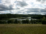 |
Ilziņš jeb Vestienas dzirnavezers pazīstams ar nostāstiem par tajā "periodiski uzpeldošām kūdras salām". Saskaņā ar vietējo iedzīvotāju sniegtajām ziņām, minētā parādība gan sen jau vairs nav novērota. Tajā pat laikā ezers un tā apkārtne ir nozīmīga daudzu aizsargājamu biotopu un sugu dzīves vieta. Ezers ietilpst Vestienas aizsargājamo ainavu apvidū. Ezeru var redzēt, braucot pa Ērgļu - Gaiziņkalna ceļu. Var pakāpties arī blakus esošajā paugurā (ziemeļos no minētā ceļa un ezera), no kura paveras plašāka skatu perspektīva.
|
|
 |
Directly by the sea, only 20 minutes’ drive from Pärnu, is the Captain's House (Kapteni talu), where the captain's freshly caught fish is turned into delicious fish dishes that can be bought or tasted in the Captain's Summer Café. |
|
 |
This was an island after the Rīga hydroelectric power plant created a reservoir, and before that it was a peninsula on the Left Bank of the Daugava. During World War I, there were massive battles between Latvian Riflemen and a much larger German army on Death Island. On December 25, 1916, the Germans used poisonous gas against the Latvian troops. In honour of this, the architect Eižens Laube designed a monument to fallen Latvian riflemen on the northern shore of Death Island. It was unveiled in 1924. Death Island can be reached by boat, and the trenches and graves there are of interest. There is a pier for boats on the north-western shore of the island, and nearby is a location for leisure. Some of the trenches and dugouts have recently been restored. The battles were described by Aleksandrs Grīns in his masterpiece, “Snowstorm of Souls.” |
|
 |
Andrupenes dabas takā var iepazīt sūnas, pārliecināties par sfagnu lielo ūdens uzsūkšanas spēju, gar laipas malām ieraudzīt apaļlapu raseni un purva dzērveni, apskatīt spilves, vaivariņus un purva vārnkāju, kā arī purva pasauli. Takas garums ~ 750m.
|
|
 |
In a document from 1387, the village is named Minor Irva. Until the mid-20th century, Mazirbe was the largest Livonian village on the coast of Kurzeme. It was a fishing village and a centre for fishing. The village had a church, school, pharmacy, forestry company, several stores, a post and telegraph office, train station, barber shop, bakery and photo workshop, as well as a brick kiln. During the 1930s, a local fishing co-operative built a fish processing plant here. The Livonian Association was established here in 1923, and the Livonian People's Centre was opened in 1939. Oppoite the centre is the Stūrīši homestead (the home of the Taizel dynasty), where you can learn about everyday household objects and, by ordering it advance, taste local foods. The first chairmen of the Livonian Association, Kārlis Stalte and Māritņš Lepste, lived in Mazirbe. Cultural worker Kārlis Stalte (1870-1978) spent man years as the verger and organist of a church in Mazirbe. Mārtiņš Lepste was a Livonian language teacher in the 1930s. The former Maritime School building can be viewed from the outside. Some 2,000 students attended the school between 1894 and 1914. During Soviet years, the army had a base here. |
|
 |
This is an institution that offers leisure activities for people of all ages. Creative workshops and various lectures are focused on families to facilitate creativity. There are kites that allow children to release their dreams into the sky. |
|
 |
This landscape park has survived to the present day and was installed between 1850 and 1860. On one side the territory has a boundary that is the dammed Kruoja River, and on the other side there is a fence made of fieldstones. The English park principles at that time meant that advantage was given to a natural landscape with imitations of nature. There are some 26 types of trees in the park, and some of them were introduced from various parts of the world a few centuries ago. |
|
 |
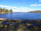
The restaurant in the relaxation complex Vonadzini, on the southern shore of Lake Ludza, not far from the city of Gulbene. On the menu: tasty fish, chicken and pork meals. Contact the venue in advance for tourist group meals, wedding banquets, etc. |
|
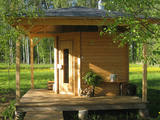 |
Sauna Museum is a private open-air museum founded in 2008. It is located 40 km from Riga by the Murjāņi - Saulkrasti road. The exhibition consists of six historic and one newly built sauna. They all work, but the hosts recommend to enjoy the black sauna. |
|
|
|
2015. gadā uzceltais skatu tornis atrodas dabas parkā „Daugavas loki”, Daugavas ielejas kreisajā krastā – Daugavpils novada Vescalienas pagastā. No torņa aplūkojama izcilā Daugavas loku ainava. |
|
 |
This is a bakery that offers traditional Lithuanian sweets, including honey buns. You can learn all about how those are produced. |
|
 |
Spieķu darbnīca Siguldā aicina izdzīvot spieķa izgatavošanas procesu, kam ir vairāk kā 200 gadu sena vēsture. Darbnīcā ir iespējams pašiem apgleznot savu spieķīti, vai iededzināt rakstu zīmes un vārdus. Spieķīši ir atpazīstamākais un senākais Siguldas simbols, kas attīstījies līdz ar kņaza Kropotkina ierīkotajām senlejas takām, kļūstot par gājēja neatņemamu ceļabiedru. |
|
 |
This structure is smaller than the Great Kangari hills – approximately 10 kilometres long and 16 metres high. This structure is near the Buļļi swamp, and the restricted area is meant to protect the structure, the swamp and the various forest types and rare plants that are in the area.
|
|


