
| No | Name | Description |
|---|---|---|
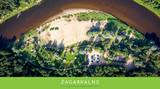 |
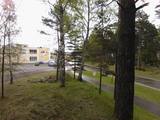
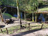
Not far from the "Žagarkalns" skiing slopes, at Cēsis, by the Gauja river. Tenting and caravan sites, boating camp. Large area, convenient for guest privacy. Cottages for parties, sauna. Boats and bicycles for rent. In winter - skiing slopes and services.
|
|
 |
The Ķemeri school was built in 1934 (architect
Kārlis Cināts). It is one of the few school buildings in
Latvia to have preserved an historically valuable interior
and exterior, including allegorical images on the façade.
|
|
 |
Innovative and delicious hemp and buckwheat products - tasty and good for the digestive system. |
|
 7 days
|
This study tour is designed to show Latvia's rye traditions as their central focus. This tour has been developed in cooperation with the Latvian Bakers’ Association. Rye is both the basis of the Latvian diet and a powerful symbol of Latvia's culture and culinary traditions. Itinerary emphasize traditional rye bread-baking and eating, as well as insights into the history of the rye grain from Latvia's earliest archaeological record to the present day. Itinerary include visits to working farms, grain mills and culturally and historically important locations. This study tour is designed for groups and may be adapted to the needs, interests and timeframe of each client. Tour cost includes meetings with experts, site visits and admissions, accommodations, specified meals, sightseeing, transportation within Latvia and guides-interpreters. |
|
 |
The History Centre Wittenstein is located in the Livonian Order castle on the rampart hill in Paide, where a time machine lift transports visitors through historic events and periods. The trip covers the period from 10,000 BC to the present day. The Centre uses lots of sound and light effects, video programmes and illusions. |
|
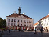 |
Formed on the left side of river Emajõgi, in the valley of Doma Hill. The centre of The Old Town of Tartu is Town Hall Square with Town Hall and the fountain "The Kiss of the Students" (symbol of the city). |
|
 |
Atrodas 200 m ziemeļaustrumos no akmens tilta pār Tebru. Ūdensdzirnavu komplekss celts 18. gs. beigās – 19. gs. sākumā uz Tebras upītes, uzpludinot Dzirnavdīķi. Blakus dzirnavām atrodas 19. gs. beigās celtā Aizputes muižas alusdarītava, apvienojot divas vecākas Pilsmuižas saimniecības ēkas. |
|
 |
The Strūves Park is toward the northwest of Jēkabpils, on the left bank of the Daugava, and opposite the Ādamsona (Krustpils) island. The park was established in the 19th century as a place where the city’s residents could relax and hold celebrations. It can be said with absolute certainty that this is a place of global importance, because the park contains a memorial stone to Professor Friedrich Georg Wilhelm Struwe (1793-1864) from the University of Tartu. He was an astronomer and geodesist. The stone is at a place where Struwe completed his land survey of the Vidzeme Province of the Russian Empire. The meridian location which Struwe identified (and other points related to those locations are found in many other European countries) is on the UNESCO list of world heritage. |
|
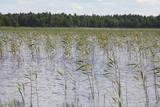 |
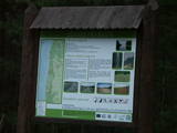
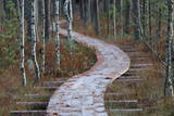
There is picnic area and information stand at the end of the forest path leading from Muiznieki to Klanu Bog. Klanu Lake was formed in the place of Littorina marine lagoon. Nature restricted area was established to protect biotopes in the area of Klanu, Dziru and Stavu Lakes. There is wide information about the area available on the information stand.
|
|
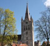 |
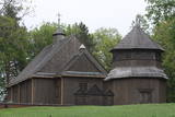
Gebaut am Ende des 13. Jh. als eine dreischiffige Basilika im romanischen Stil mit gotischen Elementen. 1853 wurde der 65 m hohe Turm aufgebaut (Aussichtsplatz). In der Kirche befinden sich die Grabsteine der livonischen Bischöfe, Kanzel (1748), Altar aus Eichenholz (1858), Altarbild (1862), Buntglasfenster und eine der besten Orgeln Lettlands (1907). |
|
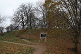 |
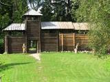
This ancient Courlandian castle hill has remnants of an ancient city. Historical sources indicate that in 1263, the Courlandians handed the castle over to the Livonian Order without a battle and that the castle was then burned down. The name of the place, Skābaržkalns, has to do with the name of the city, because hornbeam trees in the area were once known as grobi. |
|
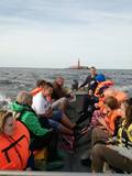 |
Piedāvā izbraucienu ar zvejnieku laivu līdz Kolkas bākai. Iespējama iepazīšanās ar zvejas procesu. Iepriekš saskaņojot, iespējams jūrā sagaidīt saullēktu vai saulrietu. |
|
 |
This territory covers the shoreline between the Ventspils-Liepāja highway and the Baltic Sea on both sides of the Užava River. The territory was established to protect shoreline biotopes such as the grey dunes, as well as a number of endangered plants. To the South of the mouth of the Užava River we find one of the most romantic lighthouses in Latvia – the Užava lighthouse, which is at the top of a steep dune. |
|
 |
This farm produces organic grains, and it has a bakery at which tasty rye bread, wheat-rye bread and croutons for bread yoghurt are produced. Bread can be purchased on site.
|
|
 |
The biography of Krišjānis Valdemārs tells us that during the summer of 1839, teachers and students from the Lubezere school spent a few days on the coastline in Roja, where Valdemārs would later help to build a maritime school. The area was breath-taking and unforgettable for the little boy. “The noble appearance of the sea grabbed the spirit of the young man so powerfully that during those three days, I thought about nothing other than the noble sea, with childish courage that allowed me to prepare a plan for a deeper port in the Roja River so that larger boats and small ships could enter it,” Valdemārs wrote. (Source: Roja TIC) |
|
 | ||
 |
Kassinurme hills were formed during the last Ice Age, and an ancient stronghold and a sacred grove can be found in the hills. At the foot of the stronghold a stage has been built; a swing, tepees, a campfire place and a model of the stronghold are located in the forecourt. Nature, health and antiquities trails are located nearby. |
|
 |
Die Kirche hat einen 1800 gebauten einzigartigen achteckigen Glockenturm. Blick auf den Lūšiai-See. |
|
 |
Pie Gārsenes pils atrodas bijušais muižas parks 4ha platībā un pie tā sākas arī Gārsenes dabas takas. Dabas takas vēsturiski tika veidotas vienlaicīgi ar pils kompleksa būvniecību un ieeja takās atrodama pie mākslīgi veidotā, ar bruģa pamatni izliktā barona peldēšanās dīķa. Takas sākumā saglabājusies ošu aleja, ko savulaik stādījis barona dārznieks, savukārt taku vidusposmā apmeklētājiem ir iespēja pasēdēt uz Barona krēsla - akmens ar cilvēku veidotu sēdvietu tajā. Kopumā Gārsenes mežā vijas dažāda garuma labiekārtotas pastaigu un izziņas takas - Kultūrvēsturiskā taka, Zaļā taka, Baronu pastaigu taka, Staburaga taka, ar ierīkotām atpūtas un ugunskuru vietām. Takās apskatāmi vairāk kā 40 unikāli dabas objekti, gan dižakmeņi, gan dižkoki, kā arī un pagasta ievērojamākie arhitektūras un kultūrvēstures pieminekļi. No 2016.gada maija Dabas takās ietilpst arī „Krēslas stundas taka”, kas īpaši patiks zinātkāriem mazajiem ceļotājiem. Taka stāsta par Rūķu dzīvi mežā un tās veidošanas pamatā ir stāsti no „Lielās Rūķu enciklopēdijas”. |
|
 |
This is another place (at A. Brodeles Street 7) which must certainly be visited by those who are interested in the cultural environment of the historical region of Selonia. The museum was established in 2000, and much of its exhibition can be found at the depot of the former narrow-gauge railroad (the depot was built in 1948, and the railroad operated between 1916 and 1972). There you can see a restored locomotive, a passenger wagon, a trolley, etc. The exhibits reflect the lives of major personalities in and around Viesīte, also looking at events and the cultural heritage. There are wood processing and textile workshops at the museum. Outside the building is a fragment from the narrow gauge railroad, along with a water pump. |
|


