
| Нo | Название | Описание |
|---|---|---|
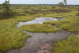 |
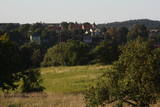
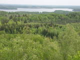
Very wide territory for a nature restricted area where extensive forests and several bogs can be found. The territory is important living space for many bird species. Vasenieku bog path with observation tower is the most attractive sites of the restricted area and offers unique landscape of the bog for its visitors. Waterproof shoes are recommended for visitors as the first 500 m of the path is molded turf rampart. Information stands are significant source of information along the path. It is suggested to visit also Stikli (Glass) village where glass factory used to be. Chandelier of Stende church has been made in this factory (by memory of Inese Roze).
|
|
 |
This is one of the most impressive and extensive natural structures of its kind in Latvia in terms of appearance and landscape. The ice age left behind this wall-like terrain, which is up to 27 metres high and at the top of which the Rīga-Ērgļi road has been built. The Great Kangari hills offer a view of the Great Kangars lake and the Great Kangari swamps and ponds. The Ķoderi castle hill, also known as the “Big Man’s Bed” is found here. The restricted area was established to protect the structure and its related biotopes and plants.
|
|
 |
There is picnic area and information stand at the end of the forest path leading from Muiznieki to Klanu Bog. Klanu Lake was formed in the place of Littorina marine lagoon. Nature restricted area was established to protect biotopes in the area of Klanu, Dziru and Stavu Lakes. There is wide information about the area available on the information stand.
|
|
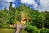 |
Klinšu smilšakmens ieži veidojušies, ūdens straumēm sanesot smilšainas, mālainas iežu daļiņas. Tās lēnām nogulsnējās un sablīvējās, topot par vareniem dabas veidojumiem! Līgatnes pagrabu alas savām rokām radījuši senie iedzīvotāji. Šī neparastā vieta ļāvusi daudzām paaudzēm izdzīvot, jo alās bija iespēja uzglabāt nepieciešamās pārtikas rezerves. Alām ir nemainīga temperatūra, kas padara tās par drošu pārtikas produktu un dzērienu glabātuvi. |
|
 |
Māras birzs atrodas apmēram 4 km no Īles, Zebrenes virzienā. 2012.gada pavasarī iestādītā piemiņas birzs ir biedrības „Zebrus draugi” veltījums šīs apkaimes ļaudīm un viņu dzimtajām mājām, kas pēdējā gadsimtā ir zudušas no Latvijas kartes. Valsts meža izcirtumā iestādīto jauno kļavu, liepu un ozolu birzs centrā izveidots Māras altāris – simbolisks akmeņu krāvums, kurā katrs, kas jūt piederību šim apvidum, var pievienot savu akmeni. Birzs projekta un altāra autors - V.Lukjanovs. |
|
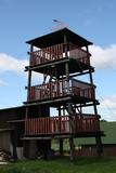 |
This is an interesting viewing tower which is part of one of the farm buildings. It offers a lovely view of the surrounding area.
|
|
 |
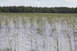
This area protects the landscape of the Lielauce hillocks, which are a part of the Eastern Kurzeme highlands. Lake Zebrus and Lake Svēte are in this territory. On the north-eastern shore of Lake Zebrus one can see the Ezerlūķi castle hill. On the eastern shore of the lake is a boating area, along with a viewing tower and a set of information about the area. The territory includes protected biotopes such as stream swamps and swampy forests, along with protected birds and species of bat. |
|
 |
This tree is the one in Latvia and perhaps the Baltic States that has the densest foliage. Its crown measures 33 x 31 metres.
|
|
 |
Oхраняемый вековой дуб местного
значения на краю улицы Тукума напротив Юрмальского
учреждения дошкольного развития "Пиенените".
|
|
 |
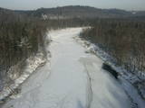
Тропа природы "Изгибы реки Риваc" начинается возле Улмалес-Лабрага лютеранской церкви и ведёт 3 километра вниз и вверх по обрывистым берегам реки Рива. Река здесь течёт по глубокому живописному оврагу глубина которого достигает 12 метров. Вы увидете бесчисленные речные повороты и крутые прибрежные скалы. Тропа частично доступна с ассистентом, тропа отмечена зеленой краской. |
|
 |
The hill is the highest point on the shores of the little Slocene River valley, and it is located in Tukums, at the side of Jelgavas Street. It opens up a broad view of the Slocene River valley and the town of Tukums with its historical centre on the opposite side of the valley. The view is particularly interesting in the evening, when the town is lit up. There is a monument to the liberators of Tukums.
|
|
 |
The impressive Gauja River valley and its best natural and cultural landscapes can be seen from Paradīze (Gleznotāji) Hill, the Sigulda castle ruins, the aerial tram, the Ferris wheel, the Ziediņi and Pilsēta ski trails, the area of the bobsled and sledding trail, Ķeizarskats, the viewing area of the Velnala cliffs, the mountain bike route of Sigulda (on the right bank of the Gauja, particularly when the trees are bare), the area of the Krimulda castle ruins, Dainu Hill, and the Turaida castle tower.
|
|
 |
Тропа создана на склоне основного берега древней долины реки Абава, где можно осмотреть рассредоточенное выклинивание подземных вод, различные типы лугов, можжевельниковые поляны и др. На береговом склоне весь год „хозяйничают” дикие коровы. 200 ступеней приведут вас к вершине берега древней долины, с которой открывается великолепный вид. Тропу рекомендуется посещать в сопровождении местного гида. |
|
 |
This lovely territory includes the hillocks of Embūte, which are in the ancient Embūte valley. The aim of establishing the park was to protect the landscape, biotopes and species of the region. An ecological tourism trail has been established in the valley, as has a forest trail through the nature park (accessibly only in the company of a guide). Visitors will learn about the hillocks and ravines left behind by the Ice Age. The ravines and the forests along their sides are protected biotopes. There are also important natural and cultural monuments, including the Embūte castle hill and the ruins of a baronial estate, castle and church. Other points of interest include the death place of the Courlandian warrior Indulis, the Joda dam, meadows, a viewing tower, etc. Three unmarked bicycle trails are in the area. |
|
 |
This territory is meant to protect the large hillocks and lakes of the Augšzeme highlands – Lake Svente, Lake Medums, Lake Ilga and others, with their islands, landscapes and species. The nature park which has been established around Lake Svente and Lake Medums is part of this territory, and there are several areas that are restricted for environmental reasons – Lake Bardinskis, Lake Skujine, and the islands of Lake Medums and Lake Svente. There is a viewing tower on Egļukalns Hill, along with downhill ski routes. |
|
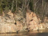 |
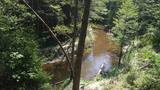
Boaters along the Gauja will see the Velnala cliffs, which are the last mighty wall along the banks of the Gauja River valley – approximately 15 m high. From the opposite shore of the river, where there are leisure facilities, once can spot the Krimulda Devil’s cave, which is in the centre of the cliff, is some 19 m deep, and is 4.7 m high. There were once wooden structures which allowed people to visit the cave, but that stopped in 1980 for safety reasons. If you head toward Turaida along the lower part of the basic Gauja River shoreline from the Velnala cliffs, then, particularly when the trees are bare, you will see the mighty sandstone Piķene cliff. At its foot is the Piķene beaver trail, which is approximately 1 km long. On quiet evenings, you may well spot a beaver at work. Along the path you will see the Small Devil’s cave (5 m deep) with the Wisdom Stream that flows out of it. The Aunapiere cave is almost as deep. Between the cliff and the Gauja are several small rivulets which are of enormous importance in preserving the diversity of the surrounding environment. |
|
 |
Lēdurgas dendroparks ir viens no bagātākajiem parkiem Latvijā. Parkā var iepazīt vairāk kā 1000 koku un krūmu sugas, pasugas un varietātes. Gadu gaitā Lēdurgas dendroparks kļuvis par dabas un kultūrvēsturisku aizsargājamu objektu. Piedāvājumā - skuju un lapu koki, dekoratīvie un ogu krūmi, vīteņaugi, ziemcietes, tējas augi u.c. |
|
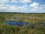 |
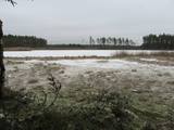
This is one of the largest high-type swamps (6,192 ha) in Latvia, with very distinct landscapes of little lakes and hillocks. The Great Ķemeri Heath is of importance as an extensive hydrological system and preserver of the local microclimate. It is also of international importance as a site for birds, as well as a major source of sulphurous water. Along the Kalnciems-Kūdra road, which is on the eastern edge of the swamp (3.4 km from the Rīga-Ventspils highway), there is an information stand with information about the management of the heath and about the role of swamps in nature and in the lives of people. Great Ķemeri Heath wooden pathway trail is now restored and opened for visitors in 2013. |
|
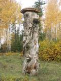 |
In 1951, when it died, the pine tree had a circumference of 4.63 metres. It was the thickest pine tree in the Baltic States
This is one of the few trees with such a long history for which age has been determined by counting up circles – 370 years. All that’s left is a conserved part of the stump at the side of the road. Cross-sections of the stump are on exhibit at the Latvian Museum of Nature and the Latvian Ethnographic Open-Air Museum.
|
|
 |
Taka izveidota Limbažu Lielezera ZA galā, tā ir 3.6 km gara vienā virzienā. Ezeru ziemeļu galā izbūvēts putnu novērošanas tornis. Izbūvēts bērnu rotaļu laukums, labiekārtotas atpūtas vietas, izveidota laivu piestātne. Pāri Donaviņai izveidots gājēju tiltiņš uz pontoniem. |
|


