
| No | Name | Description |
|---|---|---|
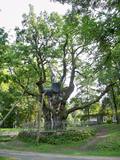 |
This park dates back to the mid-18th century and is to the south of Lake Stelmuže. There are winding trails on all sides of the hillock that lead to the Christ the King Church, with linden, maple, oak, birch, fir, elm and pine trees. At the foot of the hillock is the Laime stream, and visitors are welcome to stroll along the alley of oak trees. The oldest and fattest oak tree in Lithuania is one of the oldest ones in Europe. It is though that it is 1,500 to 2,000 ears old, and its record-setting diameter is 3.5 metres (eight or nine people linking hands are needed to encircle it). The tree is 23 m high. |
|
 |
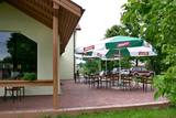
The saloon is on the Rīga-Liepāja highway (A9) at the 72nd km road marker. Live music evenings are organised. Latvian cuisine: Vidzeme salad, herring with cottage cheese and soured cream, grey peas with bacon, sautéed cabbage with sausages, cabbage rolls, potato pancakes, bread soup, stacked rye bread. Special foods: “4 vēji” – pork with sauerkraut and potatoes on a hot pan. |
|
 |
“Amatnieku namiņš” ir saimnieces izlolota sirds lieta, jeb vieta, kur vienkopus atrodami daudz un dažādi vietējo un apkārtnes novadu amatnieku un mājražotāju darinājumi. Tējas, garšvielas, ievārījumi, dažādi smēriņi, adījumi, kokdarbi, pinumi, ziedi un ziedu kārbas, sveces, krūzes un daudz kas cits ir atrodams tieši “Amatnieku namiņā”. |
|
 |
The dining room is located in the Kantküla former canteen premises, offering food from fresh, local ingredients. Dinner is served in buffet style, while in the summer season guests can also enjoy the a la carte menu or individually priced dishes. Accommodation and catering services are also provided. |
|
 |
This is the farm of a moderately wealthy Selonian farmer from the 19th century. It features a residential building with a mantel chimney, two granaries, a threshing barn, a sauna, a windmill, a smithy, a steam locomotive and a threshing machine. Groups will enjoy thematic programmes such as “Crafts at the Selonian Farm,” “When Honey Melts on Your Tongue,” and “A Wedding at the Selonian Farm.” |
|
 |
The Tado Ivanausko farm and apple orchard have a memorial museum that is in Ringaudosa in the Kaunas District. The memorial farm has a house in which the museum is located, a gardener's house, a poultry coop and a garden and park that cover approximately 4 ha. The name of the location is based on very floral and fertile apple trees. |
|
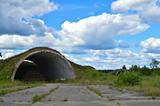 |
During Soviet times, Vaiņode was the site of one of the Soviet Union’s largest military airfields in the Baltic States. During the period of Latvia’s independence, the country’s first dirigibles were based here. Eventually their hangars were dismantled and brought to Rīga, where they were used for the Rīga Central Market. They are still there today. Some of Latvia’s first gliders took off from Vaiņode. During the Soviet occupation, the airfield was home to an air defence and destroyer squadron, with 38 SU-27 “Flanker” destroyers on site. After the restoration of Latvia’s independence, the Vaiņode airfield was dismantled in part, and the big plates of concrete that covered the runways and the rest of the airfield were used to improve the Liepāja port. There are still 16 hangars at the airport, and 1,800 of the formerly 2,500 metres long runway are also still there. More information about the airfield can be found at the Vaiņode Regional Research Museum.
|
|
 |
The Jakiškiu Estate was first mentioned in documents in the late 16th century. The estate had elements of Classicism in terms of its architecture. Among the buildings, the only ones that have survived are the mansion, an ice cellar and a steam-driven windmill. The estate has not been restored, so it is still authentic. Its artistic soul is preserved by various objects that remain from the time when people lived at the estate and from the Soviet era. Alongside the estate are a few fragments of a park, which covers approximately 2 ha. There is an ancient alley of linden trees that are on both sides of the entrance road, as well as several other valuable types of trees and a small pond. |
|
 |
The café is located the Krūziņi guesthouse in the centre of Dundaga. Latvian cuisine: Sauerkraut soup, grey peas with curdled milk, roast perch or cod, sorrel soup with potatoes. Special foods: “A tower of cottage cheese” or crème from the ingredients of the Dundaga Dairy. |
|
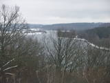 |
At the Aizkraukle Lutheran church along the upper part of the shores of the ancient Daugava River valley, there is a bit of an old road from which one of the most beautiful views of the central section of the river can be seen, particularly when the trees are bare. Approximately one kilometre to the North-west is the Aizkraukle castle hill, which offers a no less impressive view.
|
|
 |
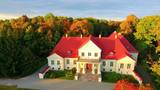
Atrodamas ziņas, ka Rankas muižas pils celta 18. gs. vidū un 19. gs. vidū (nozīmīgi - 1836.-1866.g.) pārbūvēta, kad uzceltas pārējās saimniecības ēkas. 20. gs. šeit atradās dažādas ar izglītību saistītas iestādes: 30. gados - Rankas mājturības skola, pēc 2. pasaules kara - Rankas lauksaimniecības skola. Muižas pils cieta 80. – 90. gadu mijā divu ugunsgrēku laikā. Daļēji saglabājušās kalpu mājas, kūtis, klētis, dārznieka māja, “brūzis” u.c. ēkas. Kopš 2013. gada ieguldīts milzīgs darbs, lai Rankas muižas kompleksu atjaunotu un izveidotu par sakārtotu, tīru vidi. Teritorijā notiek atjaunošanas darbi muižas ēkām. 2003. gadā par Rankas muiža kompleksa īpašniekiem kļuva Ābolu ģimene un, pateicoties viņiem, Rankas muižas komplekss pamazām atdzimst. Ekskursija pa Rankas muižu iekļauj visu telpu apskati: recepciju, antīko automašīnu un priekšmetu izstādi, mākslas galeriju, bibliotēku un Romas katoļu kapelu, kā arī muižas 8,4 hektārus plašo parku ar trīs dīķiem. |
|
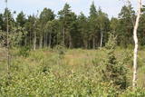 |
Similar as Alsungas mezi (Alsunga forests) – is not intended and appropriate for visits. A narrow path of the restricted area can be seen from the gravel road – Saka-Apriki. Nature restricted area established mainly for protection of Erica tetralix (often called "cross-leaved heath") and it is one of the most important growing places.
|
|
 |
Jau no seniem laikiem Cesvainē zinājuši alu, vīnu un brandvīnu. Pirmais krogs minēts jau pirms 1520.gada. Cesvaine var lepoties ar savulaik lielāko un svarīgāko krogu Vidzemē - Šļākas krogu. Barona Vulfa pils pagrabi vienmēr bijuši pilni ar labām vīna, liķiera un brandvīna pudelēm. |
|
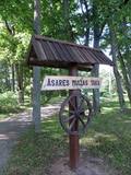 |
Asares muižas romantiskā stila dendroloģiskais ainavu parks veidots 18. gs. un papildināts 19. gs. 2. pusē. Muižas parka teritoriju ieskauj laukakmeņu mūris. Bet parkā sastopamas daudz interesantas krūmu un koku sugas: Sibīrijas baltegles, Eiropas lapegles, duglāzijas, šķeltlapainie baltalkšņi, Švedlera kļavas, košumkrūmi, dažādi lakstaugi. Liepu alejā - 2 dižkoki. Tempļa kalna atjaunotajā lapenē - muižnieku tējas dzeršanas vieta ar skatu uz pili. |
|
 |
The idea of the centre is to strengthen health by using clean food, so here you can enjoy delicious meals from slightly processed, vitamin-rich foods. The centre mainly uses fresh products from the garden of the centre and local farms. The specially developed menu plans consist of delicious vegetable soups and stews, as well as various porridges. Healing cures include not only certain meals, but also treatments and workouts that must be ordered in advance. |
|
 |
The cafe Picerija is situated in Lielvarde alongside Riga-Daugavpils highway. |
|
 |
"Cēsu maize" is located in the very heart of Cēsis, Riga street 18. Bakery makes bread from organic cultivated grains in Latvia and with natural grass. The offer includes products such as: Spelled whole wheat bread, whole wheat bread with sun-dried tomatoes and olives and spelled sweet bread. |
|
 |
The Krāslava Catholic Church was built between 1755 and 1767 after a design by the Italian architect A. Paracco, and it is considered to be Latgale’s most outstanding Baroque monument. The interior can be toured, and you can also visit the restored cemetery where members of the Plater family of noblemen are buried. |
|
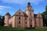 |
This convent-type castle was built in the mid-13th century by the bishopric of Piltene. Annexes were added in the 16th and 19th centuries to create a typical internal courtyard. The Neo-Gothic forms of the castle’s façade date back to the 1830s. From the 16th century to the 1920, the castle was owned by the noble Behr family. After it was burned down during the 1905 Revolution, the castle was rebuilt in two years’ time. The castle is known for ghost stories, tales of elf weddings, and stains of blood in the Red Room that are supposedly the result of a murder. A fireplace was built to hide the stains, but they reappeared. Since the privatisation of the castle, the interior has been restored with halls and cellars that are decorated with elements that are typical to the castle. Its rooms and viewing tower are open to the public. In the park, visitors will find the Alley of Love and the elf oak tree. |
|
 |
The farm is in a lovely location on the shore of a local lake. It breeds sheep, goats, rabbits and fowl. You can you on a tour, and the kids can help to feed rabbits or take a look at spring lambs. If you are interested in learning how to shear sheep, you can do so here. |
|


