
| No | Name | Description |
|---|---|---|
 |
Daugavas aizsargdambju būvniecību Jēkabpilī uzsāka pēc 1981. gada lielajiem paliem, kad ūdens līmenis pārsniedza kritisko - 6,3 m atzīmi un pakāpās līdz rādījumam „8,7 metri”. Šo plūdu laikā puse pilsētas klāja Daugavas ūdeņi. 2011. gada vasarā notika plašāki dambja atjaunošanas un labiekārtošanas darbi. Pie tā uzstādīja laternas, soliņus, izveidoja pastaigu promenādi un piemiņas zīmi Daugavas kreisajā krastā, kas parāda maksimālo plūdu līmeni. Uz aizsargdambja Daugavas labajā krastā ir izvietoti informatīvie stendi, kur var uzzināt daudz interesantus faktus par pilsētas vēsturi. Dambji ir piemērota vieta, kur fotografēt vai gleznot pilsētas ainavas. |
|
 |
The Aknīste Catholic Church was built between 1937 and 1940, and its design is based on the Kaunas Church of the Resurrection in Lithuanian. The building features the rectangular and geometric forms that were typical of the age of Functionalism. Inside is a large wooden altar, along with a pulpit and two side altars (from the early 19th century) which were once found at the Rokišķi church. They were brought to the Aknīste church when the one in Rokišķi was redesigned. In 1997 the church was granted the Blue Flag of European cultural heritage. Alongside the church are the red brick gates of an old Catholic church, which date back to the latter half of the 19th century. Also there is the Selonian Park. |
|
|
|
The Boulder of Subinaite can be found in Sakstagala rural municipality opposite Vaļenieku House that
is on the left side of the river Rēzekne. The base of the boulder is below the river level; it is 5,2 m long, 4,4
m wide, it rises about 1,6 m above the water level, about 2,5 m below the water level, capacity 26 m3.
Reddish surface is heavily eroded and full of moss. Protected since 1977.
|
|
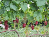 |
This is one of the largest vineyards in Latvia, with more than 50 types of grapes. The owner will take you on a tour and offer consultations about growing grapes, tastings of grapes and an ability to purchase the plants. |
|
 |
Ogu un augļu dārzs, dažādu ievārījumu, sulu, sīrupu ražošana un tirdzniecība.
|
|
 |
Ugandan Resto is a restaurant with a stylish interior, tasty food and friendly service, located in Otepää. Meals are prepared from fresh, premium local products. |
|
 |
Atrodas Tērvetes ziemeļrietumu daļā, Tērvetes upītes krasta līkumā. „Sprīdīšos” sava mūža pēdējo desmitgadi (no 1922. līdz 1933. g.) strādāja un atpūtās latviešu rakstniece Anna Brigadere (1861. - 1933). Šajā laikā top lugas, stāsti, dzejoļi un rakstnieces atmiņu triloģija. No laukakmeņiem celtā „Sprīdīšu” ēka uzbūvēta 1840 g. Te sākotnēji darbojušās ūdensdzirnavas, tad skola, dzīvojuši mežziņi. Tagad šeit aplūkojams rakstnieces memoriālais muzejs. No „Sprīdīšiem” var uzsākt garāku pastaigu pa Tērvetes dabas parku, kur izvietoti no koka darinātie A. Brigaderes pasaku varoņi. |
|
 |
Dabas parks, kura lielāko daļu aizņem neprastās formas un līčiem bagātais Cārmaņa (arī Cārmins) ezers. Ezera ūdens ir ļoti tīrs, tādēļ tajā sastopamas Latvijai retas augu sabiedrības. Tā kā parka teritorijā nav tūristiem veidota infrastruktūra, interesenti var baudīt skatus, kas paveras uz ezera un tā apkārtni no Aulejas – Grāveru ceļa.
|
|
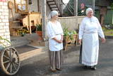 |
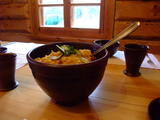
At this museum, you will learn all about the baking of bread from grain to loaf, and you can make your own loaves, too. You can taste bread and herbal teas. There are theatrical performances related to christenings, weddings, birthdays, etc. Local foods such as dumplings and soups made of dried mushrooms or lake fish are served. The museum sells freshly baked bread, as well as the work of local craftspeople. The hostess is a master baker and a member of the Chamber of Crafts. Latvian cuisine: Lake fish soup, cottage cheese dumplings and other traditional Lettigalian dishes. Special food: Soup of dried mushrooms. |
|
 |
In Seto Tsäimaja, belonging to Setos Museum, you can enjoy dishes from earthenware made according to Setos traditions, listen to Setos songs and music instruments. |
|
 17 days
|
The tour introduces modern day life in rural Latvia, Estonia and Lithuania and includes visits to small farms raising livestock and producing delicious foods, and to ethnographic villages preserving the traditional lifestyle in a contemporary environment. The tour also involves sites of historical and cultural interest. The tour gives a look beyond the usual tourism sites to get to know the three Baltic states more deeply. It starts in the historic Latvian capital, Riga, followed by the Gauja National Park with its castles, manors and walking trails. Climb the tower of medieval Turaida Castle for amazing views over the valley and visit the ancient jewellery master in the castle of the charming town of Cesis. Across the border in Estonia, walk streets with elegant villas at Parnu sea resort before catching a ferry to Saaremma island. Ethnographic Koguva village, ancient churches and windmills are typical of the island, as is an embroidering tradition. Then it's off to Tallinn with its medieval Old Town and to the rocky landscapes of Lahemaa National Park with fishing villages and manors. Try Estonian national dishes at the pub in Altja. Driving back, stop at the university town of Tartu. In Latvia again, visit goat farms and a traditional black bread bakery. Then the tour heads towards the west coast with the cities of Liepaja and, across the border in Lithunaia, Klaipeda. Next is the incredible Curonian Spit. Before Vilnius, take a detour to Grutas Park with its bizarre Soviet statuary. Finish the journey at picturesque Trakai Castle in Lithuania and Rundale Palace in Latvia. |
|
 |
Eins der eindrücksvollen Meteoritenkraterfelder Europas. Der Hauptkrater ist 22 m tief, Durchmesser – 110 m. Der ungefähre Zeitraum des Meteoriteneinschlags liegt ung. 7500-Jahre zurück. |
|
 |
This institution offers a look at characteristic rituals that relate to environmental transformation, as well as at ancient Baltic faiths. Family and calendar celebrations are held here, including weddings, hen parties, consecration, mid-winter activities, etc. Some of these are pagan festivals. The educational programmes are meant for adults. |
|
 |
Bed & breakfast "Upes", in the centre of Livonian village Pitrags. Natural toilet. Local products. Lunch boxes, transfer service on request. |
|
 4 days
|
A tour of professional farms to offer a look at modern and technologically developed farms. During the introductory day, participants will tour Rīga, which is part of the UNESCO List of World Heritage, and the Rīga Central Market, which is one of the largest closed markets of its type in Europe. The next day there will be a meeting with specialists from the Latvian Agriculture Ministry and agricultural NGOs. Next we will tour an ecological facility for farm waste, which is a pan-European initiative in the context of which heat that is manufactured is used to heat greenhouses, thus ensuring an ideal environment for farming (flowers and tomatoes). We will visit innovative farms that collect birch juice for products such as biological birch juice wine (rose, semi-sec), biological birch juice foaming wine, birch juice lemonade, and syrup. The next morning will begin with a visit to a farm that produces high-quality vegetables and potatoes, successfully dealing with the storage and sale of it produce, as well as with logistical aspects of the process. Along the way, we will visit the ruins of the Koknese castle, which is on the banks of Latvia’s legendary Daugava River. We will also visit a farm that grows hemp for various food products. We will spend the night at an aristocratic estate that is now a complex for accommodations and spa treatments. The next morning, we will be off to one of Latvia’s newest beer breweries for a tour and tastings. Around noon, we will visit a farm that manufactures co-generated biomass head during the winter and heats greenhouses. We will return to Rīga in the evening. |
|
 |
The first Mālpils dairy began operations in 1923 and manufactured butter and cheese. During the 1970s, the first soft and unfermented cheese in Latvia, “Mālpils Cheese” was produced here. Apply in advance for a tour of the company and a tasting of its products. You can purchase the products from the company’s warehouse. |
|
 |
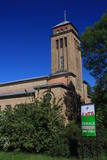
This is the highest church tower in Latvia, and from it you can see views of the Alūksne highlands. The view to the South is particularly impressive.
|
|
|
|
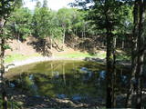
The old peat quarries is the next place
beyond Ķemeri where vast amounts of
peat were extracted, primarily during the
first period of Latvia’s independence.
|
|
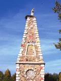 |
Monument „Carrier of the Cross”. Statue of Christ carrying His Cross is placed on a high pedestal of
the pyramid shape. The pedestal was built in 1828 by dean and writer Jāzeps Kirkillo from Rezekne. In 1918,
the monument was renovated. The new statue was placed in 1918. The monument was rebuilt once again
in 1990.
|
|
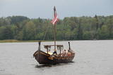 |
To view the Daugava River from a different perspective, visit the Liepkalni bakery, which offers tours in a Viking longboat that is called “Lāčplēsis” and can carry up to 24 people. The Daugava has always been an important transport corridor for many species and animals that arrived in Latvia because of that, as well as for people and tribes that lived along the banks of the Daugava River and the shores of the Baltic Sea. |
|


