
| No | Name | Description |
|---|---|---|
 3 days
|
Šis ir viens no 6 ceļojuma maršrutiem sērijā "Baudi laukus!", un tas aicina apmeklēt Lauku Labumus – visdažādāko veidu un nozaru saimniecības un uzņēmumus, kas atvērti apmeklētājiem, piedāvā ekskursijas, nogaršot, apskatīt un iegādāties savus ražojumus. Tur apskatāmi mājdzīvnieki, mūsdienīgas lauku saimniecības, amatnieku darbnīcas, iegādājami lauku produkti – maize, medus, mājas vīns un alus, siers, ogas, augļi, zivis, gaļa, dārzeņi, tējas un citi laukos audzēti labumi. Pa ceļam iespējams ieturēt pusdienas lauku krodziņos. |
|
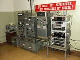 |
This extremely secret bunker was one of the most important facilities in Soviet Latvia in the event of a nuclear attack. Under the code name of “Rest Home,” the bunker is nine metres under the ground at the Līgatne Rehabilitation Centre, and it would have been the place where Soviet Latvian government officials would have gone in the event of an attack. The status of a secret object was lifted only in 2003. The underground installation has been preserved fully.
|
|
 6 days
|
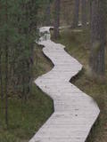
This section of the Forest Trail leads through the entire Gauja National Park and gives an opportunity to see all the most beautiful places and sights of this national park of more than 100 km. Gauja National Park is the oldest and largest national park in Latvia. The ancient valley of the River Gauja is the deepest river valley in the Baltic states. The banks of the River Gauja reveal colourful sandstone outcrops, which are reflected in the water. The sights are most wonderful in springtime, when bird cherry trees are in full bloom, and in autumn, as the trees turn red and yellow. The ancient valley of the River Gauja has a distinctive terrain relief that can fluctuate by up to 80 m. The largest part of the road leads through forest paths, along the river, and exits the woods in Līgatne and Sigulda. Almost half of the park is covered by forest. Gauja National Park is known for the great diversity of specially protected forests, featuring herbaceous spruce forests, slope and ravine forests, as well as mixed broadleaf forests. |
|
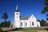 |
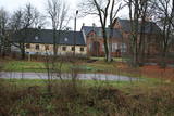
On sunny days, this white church absolutely sparkles. It is in the southern section of the village and can be seen from a great distance. Jesuits built the first wooden church at this location in 1759 in honour of St Peter and St Paul. The church that is there today was built nearly a century-and-a-half later, in 1893. The interior can be visited during worship services. Interred in the yard of the church is the Lithuanian pastor and wood carver Antons Rimovičs (1865-1933). The congregation building is opposite the church. |
|
 |
Atrodas pie Kuldīgas pils dzirnavām, kur straujā Alekšupīte pirms ietekas Ventā izgrauzusi dziļu „kanjonu” dolomītā. Šo dēvē par vienu no augstākajiem Latvijas ūdenskritumiem (4,15 m). 17. gs. ūdenskritumu ievērojami pārveidoja – paaugstināja un nostiprināja, lai Alekšupītes straumi izmantotu dzirnavu darbināšanai. Upītes kreisais krasts ir labiekārtots. |
|
 |
The trail tells about grey dunes which have survived thanks to the border restrictions and the presence of military. The trail starts from the parking place at the mouth of the Užava river. It is one of the few natural rivermouths in Europe. One can also see the „tacis”, an industrial installation for lamprey (Lampetra fluviatilis) fishing during their spawning migration period. The 3km long trail is circular. It winds for 1.5km from the Užava rivermouth to the North, along the coastline (the beach is covered with sand and pebbles), and returns to the starting point by a gravel road through grey dunes. Along the trail, one can observe a distinct white dune with rare plant species Linaria loeselii, Lathyrus maritimus, Anthyllis arenaria, Tragopogon heterospermus. About 1km from the rivermouth, in the sea, one can see a wrack of a sailing ship (parts of frame). The visibility depends on the flow of sand in the sea. The way back opens a beautiful view of the range of grey dunes. Unfortunately, Scots Pine starts taking over the area. There are three important biotopes of EU significance: „Fixed dunes with herbaceous vegetation 2130”, „Decalcified fixed dunes with Empetrum nigrum 2140” and „Dunes with Salix arenaria 2170”, forming a unique mosaic. Typical species here: mountain Alison ‘(Alyssum gmelinii), Pasqueflower (Pulsatilla pratensis), Sand Pink (Dianthus arenarius), Rosemary Leaved Willow (Salix rosmarinifolia), Dark Red Helleborine (Epipactis atrorubens), Kinnikinnick (Arctostaphylus uva-ursi). As a former military site, some military constructions can be seen here like horseshoe-shaped sand ramparts by the road in gray dunes. They were built to disguise military vehicles in case of sea attack. By the Kangroti graveyard, towards the Užava river, there is an underground pillbox. It is a one-man fortification to fire along the coastal perimeter. The Mouth of River Užava walking route is in the nature reserve „Užava” |
|
 |
Виргская господская усадьба как лен была передана вассалу Ливонского ордена Конраду Нолду. До наших дней сохранился дворец господской усадьбы «Виргас», в котором с 1935 года до наших дней разместилась школа. Во дворце находятся три двери, украшенные красивой резьбой по дереву, с гербами рода Нолдов и портреты баронов. В бывшей клети господской усадьбы в 1983 г. обустроен Дом традиций - теперь Дом культуры. Господскую усадьбу окружает парк, в котором находится место могилы барона Нолда и баронессы с памятником. В центре Вирги установлен сапог Карла XII с двумя направленными друг от друга пушками и ядрами, которые вещают о временах Северной войны, когда в Вирге в 1701 г. был лагерь шведского войска. |
|
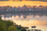 |
Krustpils was first recorded in documents in 1237 in relation to the construction of the Kreutzburg castle on the right bank of the Daugava River. A 1511 document lists it as a village. In 1585, Polish King Stefan Báthory gifted the town to Nicholas Korff, whose family continued to own it until 1920. Battles between Swedish and Polish forces occurred outside of Krustpils in 1626, and the sacked village was in poor shape until the mid-19th century. Jēkabpils, in turn, was constructed as a settlement for Old Believers who were persecuted in Russia. The Daugava has rapids opposite Krustpils and Jēkabpils, which means that boats had to dock there and reload their goods into wagons. The settlement flourished, and in 1670 it was given the rights of a city. It is named after Duke Jacob. When the Rīga-Daugavpils rail line opened in 1861, Krustpils flourished, and Jēkabpils did not flourish. The two cities were administratively merged in 1962, keeping the name of Jēkabpils. There are typical one-story wooden buildings from the 19th century, red brick buildings built at the turn of the 20th century, as well as seven churches used by different denominations. The dam along the left bank of the Daugava was built in 1861, and it was aimed at protecting the city against flooding. Today it is a promenade that is popular among local residents for strolling and leisure. |
|
 |
Farm Maizes māja near Cēsis, where you can gain joy, strength and vitality! This tourism farm offers cognitive and educational programmes for adults and children, introducing them to the traditional Latvian lifestyle and intangible cultural heritage. At Maizes Māja, groups of students, families, friends, and tourists become members of the family and have a lot of work to do, for example, bringing firewood and firing the oven, before baking rye bread or sweet and sour bread from Kaupo rye flour in a proper bread oven. When the work is done, a nice meal is enjoyed together. |
|
 12 days
|
The route leads mostly through the Gauja National Park where you will see the most beautiful river valley in the Baltic States. It is the ancient Gauja River valley with gorgeous flora and fauna and the mightiest Devonian-period sandstone cliffs, in the region. While riding the route, you can study Latvia's most brilliant medieval city, Cēsis. You can visit medieval castles and castle ruins there and in Sigulda. A guide will take through underground bunkers in Līgatne which were secret in soviet times and have no analogue in North-eastern Europe. You will then pass through the beautiful Otepaa highlands and the Lahemaa National Park in Estonia. The old town of Tallinn is on the UNESCO list of world cultural heritage. |
|
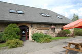 |
This saloon is located 5 km from Madona and at the edge of a highway in the forests of Smecere – the 37th kilometre of the Pļaviņas-Gulbene road. The building in which the saloon is housed was built in the 17th century, and today it is home to a modern leisure complex made up of a three-star hotel, a saloon and cafe, and a music club. |
|
 10 days
|
Этот тур рассчитан на семейный отдых. В нем культурные и природные достопримечательности сбалансированы с множеством забав для детей. Маршрут включает в себя несколько ферм, где можно понаблюдать за домашними животными и Природные тропы Лигатне, где можно увидеть диких животных. На пути есть несколько средневековых замков и живописных городов. Побережье моря встретит Вас песчаными пляжами и рыбацкими деревушками, где Вы сможете отведать копченой рыбы. Национальные парки Гауя и Слитере предложат Вам несколько природных троп и живописные пейзажи. |
|
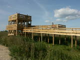 |
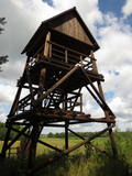
This is the only viewing platform in Latvia which is wheelchair-accessible. From the second level, you can see much of the restricted territory – areas of reeds, some wetlands, dunes and the estuary of the Daugava River. This is a good location for bird-watching.
|
|
 |
Atrodas Skuķu ezera dienvidrietumu krastā. Sasniedzams no Putnu salas, ejot cauri dzīvei savvaļā pielāgoto mājlopu aplokiem un taku. No torņa labi pārskatāma Dvietes paliene (ūdeņainos pavasaros pārplūst) un aizaugušais Skuķu ezers. Laba putnu vērošanas vieta. Putnu salas Atālu mājās – vietējais gids. |
|
 2 days
|
This route leads through the Curves of Daugava nature park, which is an area that was once to be flooded for the construction of the Daugavpils hydroelectric power plant. The central artery in the park is the ancient Daugava River valley, and the specific here is eight grand curves with a length of 4-6 km. The highest banks of the river are at the so-called Daugava gate, with the mighty Ververi and Slutiški cliffs. More than ½ of the territory is forested for hiking, nature watching, berry picking and mushroom hunting. The Daugava River valley has one of the greatest diversities of flora -- >800 different kinds in all. This is also a multinational environment with Lettigalian, Lithuanian, Polish, Russian and Belarusian traditions and heritage. The Slutiški village, which is unique in Latvia, is popular among tourists. Route information from Latvijas Lauku forums |
|
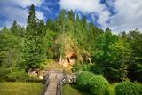 |
Klinšu smilšakmens ieži veidojušies, ūdens straumēm sanesot smilšainas, mālainas iežu daļiņas. Tās lēnām nogulsnējās un sablīvējās, topot par vareniem dabas veidojumiem! Līgatnes pagrabu alas savām rokām radījuši senie iedzīvotāji. Šī neparastā vieta ļāvusi daudzām paaudzēm izdzīvot, jo alās bija iespēja uzglabāt nepieciešamās pārtikas rezerves. Alām ir nemainīga temperatūra, kas padara tās par drošu pārtikas produktu un dzērienu glabātuvi. |
|
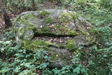 |
Near Mākoņkalns hill there is a trail that is mowed in the summer and leads to several historical rocks – Plakanais (Flat) rock, Āža muguras (Ram's Back) rock (on which you can clamber), and the Jaunstašuļi Velna pēdas (Devil's Footprint) rock, on the surface of which is a shape similar to a human footprint. There are signs along the side of the road leading to the trail. |
|
 |
Ismeri Old-Believers Prayer House was built in 1912 by the donations of local people. The parish of
Ismeri exists since 1861.
|
|
 |
The tower offers a look at the historical centre of Limbaži , the castle ruins, and the landscape all the way to Lake Dūņezers. The Limbaži castle was part of Latvia’s earliest fortifications, and its unique gates survive to this very day. Keys to the tower can be found at the museum. This is part of the ZBR. |
|
 |
One of the most attractive and informative nature trails in the environs of Rīga. It leads the visitor around the 17-metre Ragakāpa dune, which is most interesting. People can learn about the habitats of the dune areas and the plants and animals of the area. Some of the pine trees are as much as 100 years old and more. The trail is 2km long in each direction and will take some two hours to traverse. This is part of the Ragakāpa nature park.
|
|


