
| No | Name | Description |
|---|---|---|
 2 days
|
Это один из 6 маршрутов путешествий в серии «Насладитесь деревней!», который приглашает посетить «Дары села» – хозяйства и предприятия всевозможных видов и отраслей, которые открыты для посетителей и предлагают экскурсии, попробовать, осмотреть и приобрести свои изделия. Там можно увидеть домашних животных, современные сельские хозяйства, мастерские ремесленников, приобрести сельскохозяйственные продукты – хлеб, мед, домашнее вино и пиво, сыр, ягоды, фрукты, рыбу, мясо, овощи, чаи и другие, выращенные в деревне дары. По дороге можно отобедать в сельских корчмах. Примерное время прохождения маршрута: два - три дней, в зависимости от количества выбранных достопримечательностей и времени, отведенного для их осмотра. |
|
 |
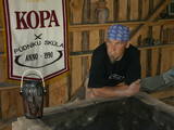
In 1804 Käsmu founded the first Estonian naval school and from 1798 – 1920 built more than 40 ships. Now there is a museum about seafaring. |
|
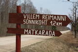 |
Kultūrvēsturiska taka (garums ~ 2 km) Tipu (Tipu) ciemā, kas iepazīstina ar vairākiem interesantiem objektiem: veco skolu (1931. g.), Hallistes upi, pirti un Paunas saimniecību, kurā dzimis viens no Igaunijas nacionālās kustības līderiem Villems Reimans (1861. – 1917.). |
|
 |
A farm engaged in the cultivation and processing of large cranberries. Offers berries, cranberry juice, syrup. On Fridays at Dundaga market from From 7:00 to 11:00 it is also possible to buy products. |
|
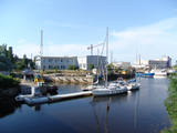 |
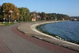
It is said that Krišjānis Valdemārs began to dream about a port at this location when he was a child, but a so-called protective port was only established in Roja in the early 20th century, with a protective dam 500 metres from the shore that was 213 m long. The dam gradually disappeared, and the port was shut down in 1933. Work on straightening the Roja River began in the 1930s, using a French machine to create berms and build rock dams and pile-based breakwaters that were subsequently extended several times. In 1932, fishermen built a 107 m breakwater. Reconstruction of the breakwaters was completed in 1972. The fishing kolkhoz Banga used to be active here, merging shoreline fishermen’s homesteads. (Source: Roja TIC) |
|
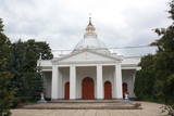 |
Atrodas Rīgas ielā 39. Dievnams celts 1848. – 1849. g. klasicisma stilā (arhitekts A. Štauberts), bet laikā no 1924. – 1934. g. pārbūvēts (A. Vizuļa projekts). Dievnama izskatu salīdzina ar Svētā Pētera katedrāles veidolu Vatikānā. Blakus baznīcai atrodas Rīgas ielas gājējiem domātā daļa. |
|
 |
Sēlijā, Zasas muižas parkā, atrodas “Bērzzemnieki”, kur saimnieko Kalnāju ģimene. Atjaunojuši vēsturisko māju un ieveduši staļļos zirgus, ģimene sniedz viesiem iespēju iepazīt zirgus, piedalīties dažādos ikdienas darbos un doties izjādēs, kā arī nakšņot “muižiņā”. |
|
 |
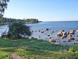
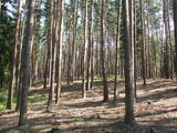
Near the Priedīši homestead, there is a nature trail which allows visitors to study Lake Dziļezers and the surroundings. There are various lakes in this region which are found in a depression left behind by the Ice Age – Lake Dziļezers, Lake Riebezers, Lake Mazezers, Lake Auziņš, Lake Skuja and Lake Bruņķītis are all there. Along their shores, there are various kinds of forests, including ones with broadleaf trees that are under environmental protection. The trail is 3km in length and will take an hour or so to traverse. This is a part of the environmentally restricted territory of Lake Dziļezers and Lake Riebezers.
|
|
 |
Pärnamäe farm on Kihnu Island has won the title of most beautiful home four times. The owner is preparing traditional, home-made dishes, Kihnu bread and smoked fish that you can also buy at Kihnu port market. The accommodation is located in three comfortable cottages. In winter, unique Kihnu carpets are made here |
|
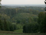 |
From the highest point in the Alūksne highlands, you will see an unusually beautiful view of the surrounding forested hillocks and the small areas of meadows and farmland. Sadly, there are no improvements to the location, which can be difficult to access. It is on private property.
|
|
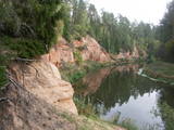 |
The Neļķes cliffs are in Skaņākalns Park, and they offer the most beautiful view of the Salaka River valley, with its sandstone cliffs and peaceful river. There are good views from the “devil’s pulpit.” It’s worth visiting the Skaņamkalns Hill to check out the views from the famous echo cliff. This is part of the ZBR.
|
|
 3 days
|
This tour will take you on a walk through the Curonian Spit from Nida to Smiltynė. The Curonian Spit National Park is located on a long, sand-dune spit that separates the Curonian Lagoon from the Baltic Sea coast. A sand beach of ~50 km is running on the western side of the dune spit, while the shore of the Curonian Lagoon is shallow and characteristic of ridged bays overgrown with reeds. The Baltic Coastal Hiking Route starts in the centre of Nida near the port. In Nida, it runs along the Curonian Lagoon promenade, offering beautiful views of the spacious waters. From Nida to Bulvikio Cape, the Baltic Coastal Hiking Route winds along small forest paths leading up and down pine-covered dunes; in the village of Preila, the trail runs along the promenade of the lagoon. Between Pervalka and Juodkrantė, the Baltic Coastal Hiking Route leads along a beautiful, sandy beach. You can take the Raganų kalnas (Hill of Witches) trail in Juodkrantė. The route alternates between the Baltic Sea coast, the dunes and the Curonian Lagoon until it finally reaches the ferry, which will take you to Klaipėda. |
|
 3 days
|
This tour will take you exploring the peculiar island of Rusnė and the delta of the river Nemunas in Lithuania. The island of Rusnė in the Nemunas Delta Regional Park is enclosed by waters of the river Nemunas and its tributaries. It is a resting place for migratory birds and home to a cormorant colony. The area of the island is 45 km2 and it is connected to the mainland by a bridge. The island of Rusnė is the lowest place in Lithuania, lying below sea level. The historic centre of the town Rusnė is characteristic of authentic wooden architecture, buildings painted in bright colours, colourful window shutters and decorations. The Baltic Coastal Hiking Route leads through the small town of Šilutė, revealing architecture that was once common to East Prussia. From Šilutė to Kintai, the Baltic Coastal Hiking Route runs along a low plain. To protect this area from flood waters of Nemunas, there is a system of dams, polders and canals established. After crossing the river Minija, the route invites you to visit the ethnographic village of Minija. Here you can enjoy the lowland landscape of the seaside region with vast wetlands and ponds. |
|
 |
The most populated place in The Curonian Spit - old curonian village - Nida. Until 19th century Nida's citizens were mainly fishermen. Later it became a popular resort. Like other villages here Nida has been "moved" because of "wandering dunes". There are a lot of museums to see. During tourism season there is around ~ 200 000 – 300 000 tourists here.
|
|
 |
The old narrow-gauge railroad. You can still see the station, the baggage
warehouse, the house where the station commander lived, and the path along
which the little train ran back in the day.
|
|
 |
Aizaudzis un purvains ezers - Ļūbasts, ar grūti pieejamiem vai nepieejamiem krastiem. Dabas vērošanai šobrīd nepiemērota vieta. Galvenās aizsargājamās vērtības - dažādas putnu sugas, t.sk. dzērves un melnie zīriņi.
|
|
 |
Ilmārs Vecelis takes part in the “Potter School” of the Latvian Cultural Fund and, therefore, uses ancient pottery methods that have been tested over the course of many centuries in Latgale. You can tour his workshop, attend the opening of the kiln, try your own hand at the craft, and commission and purchase finished ceramics products. |
|
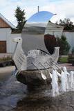 |
Arī 18. novembra laukums. Tas sācis veidoties 18. gadsimtā kā tirgus laukums. Tā dominantes bija 1752. g. celtais rātsnams (nav saglabājies) un aptieka, kas šajā ēkā darbojas no 1810. g. līdz pat mūsdienām. 2010. gadā laukumā izveidota strūklaka, kam ir pilsētas ģerboņa forma. |
|
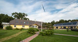 |
Nurka Farm is located in Luitemaa Nature Protection Area in Pärnu County. The farm complex that is over 100 years old has been renovated into a contemporary holiday farm with all modern conveniences. |
|
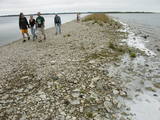 |
The Kassari Island is the fifth largest Estonian island, and it is found to the South of the Hiiumaa Island. There are two dams between the two islands, and a road for motor vehicles has been installed atop them.
|
|


