
| No | Name | Description |
|---|---|---|
 |
The property is located in the traditional fisherman's village, and local dishes and crafts are respected here. Guests are offered home-made products, as well as master classes for cooking and crafts, and are introduced to rural life. |
|
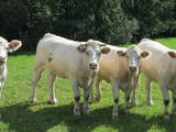 |
The farm produces vegetables, medicinal plants and honey. You can look at Charolais cattle and buy products. The lady of the house will talk about her experience in relation to her farm and biological farms that are in the neighbourhood. |
|
 |
Remnants of the plank ways of a fishing port can be seen on the shoreline and
in the sea opposite Mazirbe. They recall the former fishing co-operative Zivs, which
was here in the 1930s.
|
|
 14 days
|
A panoramic tour of Lithuania and Latvia with highlights of nature experiences in the National parks and nature reserves. A variety of landscapes, nature attraction sites, birds and wild animals, forests and seashore. The tour also offers some cultural and historical insights. Baltic States are lucky to have plenty of untouched natural territories. During the Cambrian, Silurian and Devonian eras, the territory of the current Baltic States was often covered by seawater, which is why there are places where lots of geological evidence can be found about these periods in history. These are manifested not just in fossils and various geological objects, but also in the unique landscape. For example, The Gauja River basin is an outstanding locations for Devonian cliffs and caves. Other interesting elements of the terrain relate to the development of the Baltic Sea in the past – the Baltic Ice Sea and the Littorine Sea. That is well presented at he landscape of hillocks and valleys in the Slītere National Park. Many forests and bogs have remained virtually untouched as biotopes here. The Ķemeri, Slītere national parks were all established to protect wetlands. Rivers in the Baltic States have not been straightened and dense areas of buildings are not common. There are two “lands of lakes” in the Baltic States – Latgale and Augštaitija. The Baltic States are at the crossroads of the living areas of many different plants and animals, and that is why “northern,” “southern,” “western” and “eastern” species can all be found here. Some national parks have been established to protect distinctive local cultural heritage. |
|
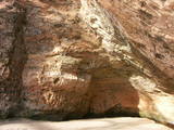 |
For more than a century now, the Gūtmaņa cave has been a popular tourist destination. It is the widest (12 m) and highest (up to 10 m) cave in Latvia. It is more of niche, actually, because its depth is just 18.8 metres. The cave is an interesting geological monument, as well as an important cultural and historical place with lots of legends, among which the most popular one centres on a woman called the rose of Turaida. It seems, however, that of the greatest historical values are the engravings on the walls and ceilings of the cave. The oldest date back to the late 17th century. A stream flows out of the cave, and it continues to shape it. People believe that the water from the stream has medicinal properties. Nearby there is Tourist Information Centre Gutmanala. Office hours: 01.05.-30.09. from 9.00 – 19.00; 01.10.-30.04. from 9.00 – 18.00. Prices for parking: 1 car EUR 2,50; 1 minibus EUR 5,00; 1 bus EUR 7,00. |
|
 |
Holiday cottage and spa located by Vertukšnes lake, offering training and services focused on the practise of a healthy lifestyle. Black (smoke) sauna with traditional sauna rituals, massages, detoxification, weight reduction, and colour therapy Bioptron pro 1.
|
|
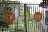 |
The first Dnyestr-M radar station was opened here in 1969 to calculate the trajectories of ballistic missiles. The trajectories of satellites were also calculated here. The range of the radar station was 5,000 km. In 1972, construction began on a second, more modern radar, the Dnyepr-M. In 1977, it was ready for use, and the first radar was modernised at the same time. The two radars were located in buildings that were 250 m long and 17 m high. During a 24/hour period, they could identify the height, speed and flight trajectory of up to 750 space objects. In 1985, work began on a third, even more modern radar – the Daryal-YM. This was a radar that could “peek” across the horizon. The antenna building was 117 m high (19 stories), 80 m long and 80 m wide. It had a planned range of 6,000 km, but it was not completed. After the withdrawal of the Russian army in 1995, the building was blown up. That cost LVL 6,172,311 and used up 360 kg of explosives. The territory of the radar stations took up 1,072 hectares, with barracks, a hotel, 551 apartments, a medical facility, a water tower, a war hospital, a bomb shelter, etc. The aim of the facility was to monitor space above Western Europe and North America, as well as to “intercept” any ballistic missiles that were fired at the USSR. The territory is closed to visitors, but it is an important part of Latvia’s military heritage. The abandoned territory can be viewed from the outside. The nearby bus stop is called “Kombināts.” This was the only facility of its kind in the Baltic States. !!! Since March 2018 the Skrunda army base is closed for visitors. |
|
 |
Muižas dzīvojamā ēka līdz mūsdienām nav saglabājusies. Šodien Dvietes muižas parkā ir apskatāmas muižas pārvaldnieka māja un trīs mūra saimniecības ēkas. 19. gs. veidots ainavu parks ar laukakmeņu mūrējuma tiltu. Parkā atrodas Dvietes muižas ēkas. |
|
 |
The Museum of Dekšāri was opened in 1996. Exposition includes
materials about the history of the rural municipality, school and collective
farms, biography of prominent people who contributed to the area, also the collection of Latgalian
literature.
Working hours: Mon– Fri : 10.00 – 14.00, Sat., Sunday : closed |
|
 |
This progressive biological farm grows some 50 types of biological vegetables and greens. The farmers own 10 ha of land where they grow various vegetables outdoors and in greenhouses in the Biržu region. |
|
 |
Muižas ēka tikusi restaurēta, taču tā celta 1732. gadā. Muižas kompleksu veido – kungu māja, bijušās skolas ēka, pārvaldnieka māja, klēts, saimniecības ēka, kā arī tējas namiņš, kas atrodas senajā ozolu parkā, no kura takas tālāk aizvijas uz Meža parku. Ungurmuižas iekštelpās ir grezni zīmējumi (grenadieri, ziedu motīvi, zīmētas tapetes, drapēri, ainas no barona karagājieniem un ceļojumiem) kuru autors ir Limbažu gleznotājs Georgs Dītrihs Hinšs. Ungurmuižā par seno auru rūpējas katrs gleznojums, zīmējums un katrs nostūris. |
|
 |
The hatchery of decorative saplings and their sale (thujas, junipers, meadowsweets, weigelas, barberries, roses, etc.); creating and nurturing a commercial black currant garden, consultations. |
|
 |
The open kitchen of the restaurant allows the guests to experience an exciting performance by its chefs, who cook various fish and meat dishes on a fiery charcoal grill. Chef: Lauris Aleksejevs. Three-time consecutive winner of the Best Restaurant in Jūrmala title. |
|
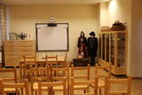 |
This collection features the heritage of the Suiti people, including an exhibition of folk costumes. Visitors can learn about the costumes and try them on. This is a cosy place for meetings, with well-equipped rooms for seminars and various types of training sessions. |
|
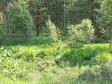 |
The word grīnis in Latvian refers to a very unusual type of forest – pine trees growing on sandy soil. There are two types of this environment – the heather type and the grass type. This is the result of long-lasting interaction between nature and humankind, and such sites are found in just a few places along the shores of the Baltic Sea in Latvia. A very rare plant which grows in the area – cross-leaved heath – was the main reason why a nature reserve was established here in 1936. An abandoned former rail line between Ventspils and Liepāja crosses the reserve from the North to the South. Visits to the reserve are strictly prohibited. |
|
|
|
This former training route runs through the shoreline forests from the northern part of Ventspils (there was once a tank division in Ziemeļu Street there) all the way to Ovīši. Today it is a wide, sandy and overgrown track.
|
|
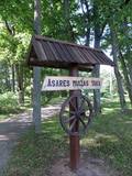 |
Asares muižas romantiskā stila dendroloģiskais ainavu parks veidots 18. gs. un papildināts 19. gs. 2. pusē. Muižas parka teritoriju ieskauj laukakmeņu mūris. Bet parkā sastopamas daudz interesantas krūmu un koku sugas: Sibīrijas baltegles, Eiropas lapegles, duglāzijas, šķeltlapainie baltalkšņi, Švedlera kļavas, košumkrūmi, dažādi lakstaugi. Liepu alejā - 2 dižkoki. Tempļa kalna atjaunotajā lapenē - muižnieku tējas dzeršanas vieta ar skatu uz pili. |
|
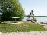 |
Viewing tower on pontoons, and there is a footpath to get to it. The tower offers a view of nearly all of Lake Sloka, all the way to Kauguri. Particularly visible is the northern part of the lake. There is also a sulphur spring. The site is good for bird-watching throughout the year, including the winter, because parts of the lake do not freeze over. |
|
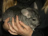 |
The owners breed chinchillas, which originated in the Andes in South America. They offer a tour and a story about the lives and growth of chinchillas. Animals and their pelts can be purchased. The lady of the house is also a painter. |
|
 1 day
|
Tūrisma gide Ineta Jansone piedāvā ekskursijas grupām uz Ķemeriem un iepazīstina ar Ķemeru kūrorta vēsturi. Kopš seniem laikiem Ķemeri slaveni ar to, ka šeit ir daudz sērūdeņu avotu un ārstnieciskās dūņas. Šurp brauca ārstēties kopš 19. gs. sākuma. 1838. gadā Ķemeros nodibināja kūrortu. Ķemeru kūrortā ārstēja ādas un kaulu slimības, kā arī gremošanas un nervu sistēmas slimības. 1877.g. izbūvēja dzelzceļa līniju Rīga - Tukums, bet 20.gs. sākumā tika ieviesta tiešā dzelzceļa satiksme ar Maskavu. Kūrorts bija ļoti populārs un katru gadu arvien vairāk viesu brauca šurp ārstēties. Īsi pirms I Pasaules kara atklāja elektriskā tramvaja satiksmi starp Ķemeriem un jūru - Jaunķemeriem. Ķemeri atrodas starp purviem un ezeriem, 6 km attālumā no Rīgas jūras līča. |
|


