
| No | Name | Description |
|---|---|---|
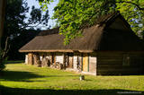 |
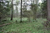
Third biggest island in Estonia. Full of beautiful grown junipers, little dolomite outcrop on the coast of the sea and fishermen villages on the coastline. |
|
 |
The 60 km cross-border cycling trail along the Koiva/Gauja River in Estonia and Latvia was completed in 2010. The trail begins at Tellingumäe car park, start and finish points of the trail and the border crossing site are supplied with resting areas and information boards with maps. Signposts are located at crossroads where there may be confusion for cyclists; attractions near the main route are also signposted. Information boards are provided in Estonian, Latvian and English. Tellingumäe car park is also a starting point for an 18-km cycling route. |
|
 |
Pastāv uzskats, ka tieši Rubenē izveidojusies pirmā latviešu draudze. Baznīcas altārdaļa būvēta jau 14.gs., bet pati baznīca savu pašreizējo izskatu ieguvusi 1739. gadā.Būtiska baznīcas interjera sastāvdaļa ir Ķieģeļu muižas mantinieces Barbaras Helēnas fon Budbergas 1762. gadā dāvinātais kroņlukturis ar Krievijas impērijas divgalvaino ērgli un zaru ornamentiem uz bumbas. Baznīcā redzama arī zīme (1869. g.), kas ir veltīta pusgadsimtam kopš dzimtbūšanas atcelšanas. Pastāv vairākas teikas par Rubenes baznīcas nosaukuma rašanos. Viena no tām vēsta, ka, sargājot baznīcu no velna, tās sienā iemūrēta sieviete un vīrietis, kura vārds bijis Rubens. Baznīca esot nosaukta viņam par godu.Vēl viena versija vēsta, ka baznīcas nosaukums cēlies no rubeņa, kas sēdējis kādā no kokiem, kas vēlāk izmantots baznīcas celtniecībā. |
|
 |
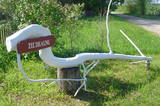
Pupuchi ražotnē top kraukšķīga un veselīga uzkoda no cūku pupām - Pupuchi. |
|
 |
In the workshop you can see how wool becomes yarn using old techniques and how knitted and woven items are made today. You can try your hand at carding wool, spinning yarn and weaving a rag rug on looms. |
|
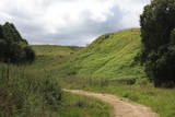 |
Found on the right bank of the Daugava, approximately half a kilometre upriver from the Skrīveri Agricultural Institute, the hill is in a place where the bank of the Daugava River Valley is split by the deep Ašķere stream valley. The castle hill was occupied beginning in the first millennium BC, with antiquities from the Lettigalian and Livonian tribes found there. During the 13th century, a brick castle was built on the hill, but it was sacked during the 17th century. Nothing remains of the castle. The castle hill is also known as Raven Hills, and it offers one of the most beautiful views of the central part of the Daugava. In the direction of Rīga, there is a field with a white cross that represents an ancient church. There is a hiking trail along the Ašķere stream. The area is well improved with four trails. The longest is the Daugava trail (10 km). |
|
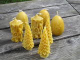 |
This farm is an apiary, with hives of bees gathering honey. The farm has won prizes for its products. You can take a tour and learn about the lives of bees and beekeeping products, make your own wax candles, or attend educational seminars. |
|
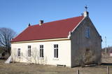 |
This is a simple one-story building with a cross on its roof. The Pitrags congregation was established in 1890, but the church was built in 1902. It was restored after a World War I fire in 1925 and 1926, and restored again during the period of Latvia's restored period of independence. |
|
 |
A straight street which runs through Ķemeri in the northwestern-southeastern direction. The street's name is a proof that it is the former historical boundary between the regions of Vidzeme and Kurzeme. Near the intersection of Robežu and Tukuma streets, you can notice the former pharmacy building-the memory of the former resort of the all-union significance. On the walls there has survived the pharmacy-related symbolism. |
|
 |
Šūpošanās ir veselīga nodarbošanās, šūpoles ir enerģijas uzkrāšanas avots. Kad dabā veidojas spēcīgs enerģijas maksimums, šūpojoties iespējams saņemt īpaši daudz. Šūpoles ļauj atrauties no zemes, kaut uz mirkli. Parka teritorijā ir brīvdabas pavarda vieta un pirts. Saimniece piedāvā profesionālus pirts rituālus un nakšņošanas iespējas. |
|
 |
From the 6th century until the 8th century instead of the current Grobina the largest known Scandinavian trade and warrior colony in the Baltic States was located. Settlers from the inlands of Gotland and Sweden established their settlement at the hillock that was then located at the bank of the navigable Alande River. It is believed that the Cours Castle – Seeburg mentioned in the chronicles of the 9th century was located exactly here. After the loss of the order castle in the 13th century Grobina became the centre of the region. The most ancient construction of the city was formed around Lielā Street, as well as around Saules and Parka Streets. |
|
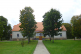 |
The Ance Estate was built for Ulrich Johann von Behr by his father as a gift. The estate was once surrounded by an ornate French garden. Beginning in 1766, the building was rebuilt and ornately decorated. Around 1810, French soldiers occupied the mansion and caused much damage to it. For that reason, the second floor was torn down a bit later, and extensive renovations were conducted to adapt the estate into apartments for the manager and his civil servants. In 1920, the estate was taken over by the state. The lady of the house will teach visitors to bake carrot buns and talk about the history of the pastry. The workshop of a craftsmanship group offers a look at the work of craftsmen and a chance to try the crafts yourself. |
|
 |
One of the rare places (see also Rucavas ivju audze) in Latvia where two rare and protected wild tree species grow - yew-tree and Baltic ivy. Territory is not marked on site with information signs or stands. Territory is not suitable for visitors as visitor without environmental knowledge will see “regular” forest. On the East side of the restricted area is located extending low wall – former narrow gauge railway (600 mm, length 41 km) line Dulbeni – Rucava. Railway was built by German military forces with the goal – to export wood.
|
|
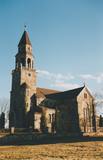 |
The church was built of fieldstones between 1908 and 1925 in the Tudor Neo-Gothic style (designed by the Liepāja-based architect Stadmann). It replaced a wooden church that dated back to 1621, and its steeple offers a lovely view of lakes that surround the village of Višķi. |
|
 |
To the East of the Ezermuiža-Dūmele road you will find the bed of the ancient Lake Dieviņezers. It was one of the largest lakes in Kurzeme in the past, being 7.5 km long and 1.6 km wide. A canal was dug in 1838 (Melnsilupe River today), and the water from the lake was siphoned to the sea so as to create fertile farmland. Residents of Ezermuiža have been involved in forestry work since the age when barons ruled the land. Dūmele is connected to Košrags by a lonely forest road that is known as the Bottom Road. A bike route runs down it. The Ziedkalni weekend house is in Dūmele. The "Ziedkalni" homestead in Dūmele offers spa services, cod fishing and accommodations. |
|
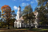 |
The church was built during the rule of Baron Otto Hermann von Fittinghof and built between 1781 and 1788 by the architect Christoph Haberland. Built in the style of Classicism, the church has elements of the Baroque style and a set of colourful rocks in a mosaic on the façade. The organ was built in 1855 by August Martin, and the bell was evacuated to Russia during World War I. The congregation replaced it with a much older bell (1530). The altar painting, “Baptism of Christ” was pained by an unknown artist and was restored in 2000. During the mid-19th century, there were many Estonians in the congregation, so worship services were held in Estonian, too. The church was restored in 1934, and now it dominates the city with its 55.5 m high tower. |
|
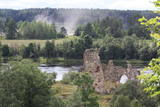 |
Found on the right bank of the Daugava where the little Karikste river flows into the Daugava, all that remains of the castle today is a set of ruined walls and foundations. The castle was built by the Livonian Order in 1224, and it was inhabited until the mid-17th century, when it was sacked during the Polish-Swedish war. The ruins offer a good view of the local gravel road that goes along the right bank of the river valley.
|
|
 |
Energia (Energy) Farm beside the Navesti River is the largest Estonian company to ecologically grow and process herbs. There is a big herb centre with herbal trails, a modern teahouse, a seminar centre and an eco-spa; the farm’s accommodation features all modern conveniences. |
|
 |
Zemnieku saimniecība "Mežnoras" Raunā izveidota 1993.gadā. Saimnieki Aivars, Ārija un Līga Urbasti šobrīd audzē 1,6 ha vasaras un rudens avenes, arī nelielās platībās zemenes uz lauka un segtās platībās, siltumnīcā. Zemenes no "Mežnorām" parasti pieejamas laikā no maija vidus līdz oktobra vidum. "Mežnorās " audzē vasaras avenes "Norna", rudens avenes "Babje ļeto", “Polana”, populāro zemeņu šķirni “Polka”. No savā dārzā audzētajām ogām (upenes, jāņogas, ķirši, zemenes u.c.) Aivars gatavo mājas vīnu: "Mežnoru vīns pilnībā sākās Mežnorās. Tas piedzimst nevis mucās, bet sākas mūsu zemeņu vai aveņu laukā, un tās ir daudz dziļākas saknes, kas atstāj pēdas arī garšā”. Saimniecībā audzētais pieejams uz vietas Raunā, gan arī Straupes Lauku labumu tirdziņā, Straupes Hanzas tirgū, arī sezonā - Cēsu tirgū. |
|
 |
This is about 30 km long territory between the Baltic Sea and the Kolka-Ventspils road. It begins at the mouth of the Irbe River and ends at Ovišrags. The territory was mostly established so as to protect dry coniferous forests, grey dunes, damp areas among the dunes, other landscape features and plants and animals in the area. Distinctive landform - kangari and vigas - and grey dunes are Europe-wide significant habitat. Tourists love the sandy and quiet beaches of the area, as well as the Miķeļbāka and Ovīši lighthouses (it is possible to visit Oviši lighthouse and museum in it) and the Lutheran Church at Miķeltornis. There are also certain leftover elements of the Soviet military system, former narrow gauge railway (railway embankment, former train stations marked by memorial stones etc.) which unfortunately are not used as tourism resources. |
|


