
| No | Name | Description |
|---|---|---|
 |
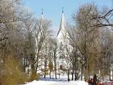
Dabas liegums veidots ezera, tā salu, ainavas, augu, putnu un sikspārņu aizsardzībai. Liegumu var apskatīt "no malas" - no ceļa, kas iet gar tā ziemeļu un ziemeļaustrumu robežu.
|
|
 |
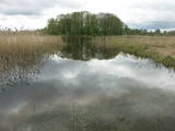
The barrow which offers a good view is at the northern end of the Dunduri meadows – at the end of Melnragi. It is an artificial barrow which follows along with the bed of the little Slampe River. The meadows are home to livestock allowed to live in the wild, and you can see a bit of the restored Slampe. The view is particularly interesting during flooding season, when the surrounding wetlands become saturated. This is a location for bird-watching.
|
|
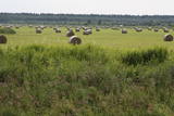 |
Open landscape area within farming lands on both banks of Uzava River about 10 km before it flows into the Baltic Sea. There is a good open view over the area from the Vendzava-Ziri road going through the nature park. Protection of migratory birds and corncrakes has been one of the main reasons for establishment of the nature park. Bird watching is possible from the road Vendzava-Ziri during migration period in spring and fall. There is no tourist infrastructure in the nature park.
|
|
 |
This park surrounds the mansion of the Biržuvenai Estate, and it is based on the terrain of the Virvite River and an old river that provides water for the park. The central part of the park is regularly designed, while the rest has elements of landscape. Opposite the estate is a glass sculpture, and on its western side is a wooden pergola. Local trees dominate in the park, but there are also trees from other countries. Of importance is a group of oak trees on the banks of the river, as is an alley of linden trees that leads to the pond in the direction of the estate. |
|
 |
Īdeņa Castle mound is located near Lake Lubāns. A beautiful view
to the lake and to the marshy meadows. The place was inhabited from
the 11th century.
|
|
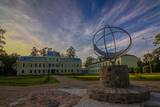 |
Pirmie dokumenti par Kokmuižu atrodami 1601. gada zemes revīzijas pierakstos. Tur sniegtā informācija vēsta, ka Kokmuiža pastāvējusi jau 1560. gadā. Taču 1880. gadā vācu muižnieks sākas celt kungu māju neobaroka stilā. 20. gs. sākumā tā tika izpostīta, bet 1937. gadā to pārveidoja par skolu. Kokmuižā kādreiz atradusies alus darītava. Tas bija laika periodā no 17.- 20. gs. Tā bija viena no slavenākajām alusdarītavām visā Vidzemes guberņā. Mūsdienās var izstaigāt muižu pats vai gida pavadībā. Var aplūkot kungu māju, staļļu ēkas, muižas pārvaldnieka namu, bibliotēku, ekspozīciju, abas klētis un alus darītavas pagrabu, kā arī sfērisko saules pulksteni.
|
|
 |
Ligatne history is inextricably linked to Ligatne paper mill. At the end 19th century and beginning of 20th century here was built houses, schools, maternity homes, hospitals, clubs, guest houses and other buildings for workers that have survived to the present. During the Soviet period Ligatne mill produced mainly school exercise books, which was sent to all the Soviet republics. Nowadays, the main raw material is recovered paper used for production of wrapping paper. Ligatne paper mill is the only one functioning Latvian company of this kind, and it can be explored with a local guide. Historic centre of Ligatne paper mill has been awarded the status of cultural monument. In the northern part of Ligatne - Gauja river bank the only functioning Gauja river ferry can be found and the only river ferry in the Baltic States, which is powered by river current. The ferry is vehicle of local scale. In the west of Ligatne, Ligatne nature trails are located; where close to natural environment conditions (the best object of this type in the Baltic States) lives red deer, roe deer, wild boar, fox and lynx. Within the territory of Ligatne nature trail a dense network of hiking trails and paved road - cycling route has been created, during the winter it becomes a cross-country ski track. A modern visitor centre is available here. East of Ligatne at Ligatne rehabilitation centre a unique place on the Europen scale can be found - a former Soviet secret bunker that was built as the main living and working place of Latvian senior military and civilian persons in case the nuclear or chemical weapons were used. Bunker was opened in 2003; therefore it remained intact to this day. On the way from Augsligatne to Ligatne go to see Vienkoci Park, where you can explore boats made of single wood peace by the creator of Park Richard Vidzicka, look at the different building models, sand home, and participate in themed activities. |
|
 |
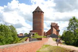
The complex dates back to the 17th and 18th century, when a fortress was replaced by a mansion and other buildings. The rectangular yard that is in the centre of the state is surrounded by the mansion, two granaries with columns that were built opposite one another, a stable and a wheelhouse. The stable and wheelhouse, the bell tower and the gate create the most impressive part of the buildings. Bells were rung because of religious rituals, but also to inform people at the estate about everyday issues. The silhouette of the building is reminiscent of cloisters, city halls and churches that were common in Europe in the 18th century. In 1780, the estate was taken over by the family of Karl Otto von Löwenstern, and the mansion can only be viewed from the outside. There is a hiking trail near the estate. |
|
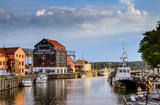 |
The former Memele. The only port city with a old town in Lithuania. |
|
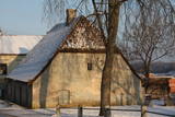 |
This little building is on the left bank of the Venta River beyond the ancient brick bridge. It is located at Pils Street 4. The hut was built in 1735, using rocks from the damaged castle of the duke, and it was built on a terrace that is the last fragment of the walls that surrounded the castle. Also known as the Hangman’s hut, the building was rebuilt during the 19th century. It can only be viewed from the outside. |
|
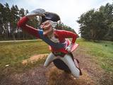 |
The restored mansion of the Dunte Estate is now a museum featuring the adventures and life of the legendary king of lies, Baron Munchhausen. The first floor is devoted to the barn and his stories, while the second floor has a collection of wax models of people who are distinguished in terms of Latvia’s history. Also there is the largest collection of beer mugs in Latvia. There are three circular trails in the forest with wooden sculptures. The longest one leads to the sea. A wooden model of a ship is interesting to children. |
|
 |
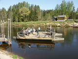
Rancho Riisa is located in Soomaa National Park (Soomaa Rahvuspark), where there are a lot of fruits of the forest to be used in cooking. After a stroll through the national park and a refreshing sauna, the hosts will offer the best meal in Soomaa traditions. |
|
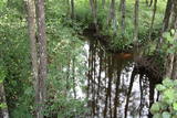 |
This territory is on both sides of the central section of the Raķupe River. On the banks of the river, there are many different meadow habitats, as well as massive oaks growing in the places of former farmsteads which are uninhabited by now. This is an important place for rare plants and animals. There is no tourism infrastructure for visitors in the area. Visitors who are especially interested in the environmental cognition are advised to visit the territory in attendance of experienced local guide. Raķupe is not usable for water tourism because of tilts of trees and beaver dams. |
|
 |
The “Kukaburra” café is located on the 115th km of the Riga-Veclaicene highway (A2). It is possible to see the Bread museum. Guests can take part in baking rye bread every weekend. The café has a Latvian interior and serves products from local farmers and home-based producers of ingredients. Latvian cuisine: Chicken liver salad, lamb soup, dumpling soup, cold soup, baked catfish, sautéed pork, potato pancakes, pancakes with jam cottage cheese buns, stacked rye bread. Special foods: Home baked rye bread. |
|
 |
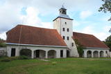
Holy Jesus Heart Roman Catholic Church of Bikova
(Gaigalava). Enjoy the Gothic forms and architectural design of the church. The church and the altar are
decorated with the icons of Zebedee sons – James and John (the apostles of Jesus) and other saints.
|
|
 |
Before the stone Turaida Castle was built beginning in 1214, there was a wooden castle there that had been built by the Livs. The Turaida Castle was owned by the bishop of Rīga. It remained in place until 1776, when it burned down. The initial entrance to the castle's main tower was 9 m above ground, and in 1936, a viewing platform was installed at a height of 27 metres. There is no other view in Latvia that is like the one from the Turaida Castle! Restoration work at the castle began in 1953, when the upper level of the tower was restored and a roof was installed. Also restored was the former granary, which was home to an exhibition about the Sigulda region, along with the semi-circular tower and the southern segment of the castle complex, complete with the full reconstruction of its historical interior. Archaeological work was done around the castle between 1976 and 2001, and this led to the restoration of a large part of the complex. The castle now contains a museum exhibition related to the historical events of the surrounding area. The Turaida Castle is in the Turaida Museum Reserve (see above). |
|
 |
Tihuse farm provides accommodation and horse riding from trekking to carriage rides. A signposted heritage trail starts at the farm and tells the story of people and Nature; you can also learn about old beliefs and customs. The teahouse exhibits photos of places linked to Muhu island’s heritage. |
|
 |
Pirms dodamies tālāk – Skaistkalnes virzienā, var izmest nelielu loku līdz Lejeniekiem, kas atrodas skaistā vietā – Mēmeles kreisajā krastā, 6 km austrumos no Bauskas. Latviešu dzejnieka Viļa Plūdoņa (1874. – 1940.) memoriālais muzejs dibināts 1968. g. viņa dzimtajās mājās „Lejeniekos”. Zemgales daba un vecmātes stāsti būtiski ietekmēja nākamā dzejnieka daiļradi. Šeit nokļuvušie var apskatīt ratu un etnogrāfisko priekšmetu kolekciju, izstaigāt Plūdoņa taku vai apmeklēt dzejnieka un viņa radinieku atdusas vietu netālu esošajos kapos. Bērniem noteikti jāiegriežas “Zaķīšu pirtiņā”. |
|
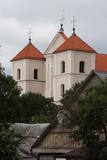 |
Baznīca atrodas Sodu ielā (Sodų gatve) 8. Tās pirmsākumi meklējami 1409. g. (viena no vecākajām Lietuvas baznīcām), kad Lietuvas dižkunigaitis Vītauts Dižais izveidoja Traķu apgabala baznīcu. Dievnams joprojām ir pazīstams ar 1123. g. Konstantinopolē gleznotās Traķu Dievmātes gleznu, kuru it kā Vītautam 1390. g. uzdāvinājis Bizantijas ķeizars Emanuels Paleologs II. Šis fakts gan ir jāuzskata par leģendu, ko aprakstījis vēsturnieks Albertas Vijūkas – Kojalavičius, jo 1645 g. gleznas restaurācijas laikā noskaidrojās, ka tā ir tapusi 15 gs. beigās vai 16. gs. sākumā. Traķu Dievmātes glezna ir pirmā Lietuvas pāvesta vainagotā glezna (vainagošanas ceremonija notika 1718 g.), pēc kuras brīnumus piedzīvojuši daudzi ticīgie - gan katoļi, gan pareizticīgie, gan pagāni, gan tatāri. Latvijā - Aglonas bazilikā atrodas šīs gleznas kopija, ko uzskata par svētu! Vislabākais skats uz baznīcu, Traķu ezerpili un Traķiem paveras no klaja paugura Galves (Galvė) ezera ziemeļu krastā. |
|
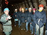 |
Gas mixture is the main raw material for Estonia’s energy and chemical industries, and it is extracted in our day from open quarries or underground shafts. This layer was established during the Ordovician Period between 450 and 480 million years ago, and it is made up of the remnants of plants and animals from that age. In the Kohtla-Nõmme suburb, there is a shaft which can be toured in the company of a guide who will tell you that this is the only layer of its kind in the Baltic States. He will tell you about how the gas mixture has been extracted over the course of history.
|
|


