
| No | Name | Description |
|---|---|---|
 |
The café is alongside the Top store in the centre of the village. Latvian cuisine: Potato pancakes with ham, grey peas with bacon, carrot buns. Special foods: The special “Apsīte” potted dish. |
|
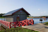 |
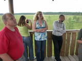
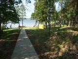
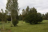
In the recreation complex it is possible to fish in the carp pond, as well as to swim and sunbathe on the landscaped beach on the loungers. There is a playground for children. It is also possible to organize banquets, seminars and other events. There is also a sauna with a fireplace hall for relaxation for up to 20 people. There are four campsites for accommodation, located above the water on piles. All cottages are heated, with separate shower and toilet, TV and wi-fi internet. Two of them have a kitchen, and one has a fireplace. Each cottage has three or four beds. Tents and camper sites are also available, and tents can be rented on site. |
|
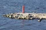 |
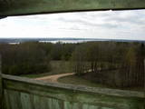
The Eastern breakwater was installed in the mid-19th century to reduce silt in the river valley and to regulate the flow of water. It is made of wooden pilings that are covered with rocks. The breakwater is 2.2 km long and has been rejuvenated as a popular place for hiking, leisure and fishing throughout the year. Birds can be watched from the breakwater, and sometimes people are lucky enough to spot a seal. At the start of the breakwater are two rocks with engraved text to say that the site was visited by Russian Tsar Alexander II in 1856 and by his heir, Nikolai Alexandrovich, in 1860. This points to the importance of the Rīga port in terms of Baltic Sea trade routes at that time. |
|
 |
Of the many islands in Lake Rušons, ten are restricted natural areas so as to protect the broadleaf forests which are on the islands and the endangered plants found therein. An ancient cult location – the Rušons Sacrificial Rock – is found on Upursala island.
|
|
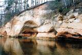 |
This is one of the most beautiful ancient river valleys in Estonia – 12 km long with nearly 40 revealed Devonian sandstone cliffs. Among these, the most important ones are Viira müür, Kalamatu müür, and Põdramüür.
|
|
 |
The Smārde saloon has a very long history,
and food is served here. There is a car park, and
approx. 100 m to the East is a cemetery and
monument to commemorate soldiers who fell
during World War II.
|
|
|
|
After the death of the Kalnasikšņi oak tree, which was the mightiest tree in the Gauja National Park, the mighty Kvēpene oak tree has taken over that role. It has a circumference of 6.1 m, a height of 20 m, and a crown which measures 28 x 30 m. The beautiful tree is on the right bank of the Gauja River valley and is one of the most excellent trees in Latvia. Near it is the forested Kvēpene castle hill, as is the Svētavots stream, which is reputed to have medicinal waters. To the North of the castle hill is the Rūsiņš hillock, which offers a good view of the surrounding forests, the towers of the city of Cēsis, Ieriķi, and the Rakšupe estuary at the Gauja. There is a bench at the top of the hillock from which lovely sunsets can be seen. |
|
 |
The tower is beyond the Oleri estate, in the small Oleri swamp, where at the end of a wooden footpath you can step upward a bit and learn about the landscape of a transitional swamp. This is part of the ZBR.
|
|
 |
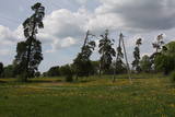
This is one of the highest points among the hillocks of the Selonian area of Zemgale – Borīškalns Hill. From the tower, you will see Lake Sauka, as well as the forests and farmland which surround it. The “Kalna Ļūdāni” farm is nearby, and its owner uses his livestock to help to maintain the surrounding landscape.
|
|
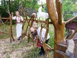 |
This park is a network of farms in Kaika area where visitors can learn about healthy life styles and alternative medicine. Farms have programmes on using herbs and leech in therapies, on the magical worlds of bees and mushrooms, spells and meditation. In workshops you can learn to use weeds in cooking, make bread and herbal drugs. Individual travellers are welcome to explore the farm on their own. |
|
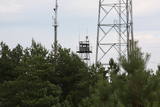 |
The military communications facilities at Pāvilosta are along the southern part of the town. The facilities are owned by the local government, and there is no information about their use at this time.
|
|
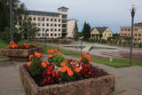 |
Madonas centrālais laukums, kas vēl 20. gs. sākumā bija tirgus laukums. Pēc apjomīgās restaurācijas tas ir kļuvis par ievērības cienīgu pilsētvides objektu. Laukuma ziemeļu pusē atrodas pilsētas un novada pašvaldība un Madonas novada TIC. |
|
 |
The restaurant is alongside the Villa Elizabete guesthouse with a summer terrace and a fireplace room and library where diners can enjoy their meals when it is cold outside. Latvian cuisine: Marinated Baltic herring with cottage cheese, cream of mushroom soup, grilled pork chop, veal steak, grilled tench. Special foods: Captain Grant’s cheesecake. |
|
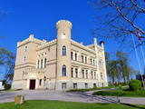 |
The mansion of the Gārsene Estate is built in the Neo-Gothic style, and its design was based on a villa in Germany. The building was erected between 1856 and 1860, and from then until 1920, the baronial dynasty of the Budbergs and Beningshausens owned it. The castle was expanded with another wing in 1885. Between 1939 and 1940, the building was rebuilt to become a school, and President Kārlis Ulmanis attended its opening on June 2, 1940, when he was taking his last official trip as the country’s president. There are other buildings and a park on the estate. The mansion today is home to the Gārsene Elementary School, but there is also an exhibition featuring the baronial dynasty, the history of the school, and the town itself. Just wait until you see the pot-bellied stoves! Outside the mansion are the Gārsene nature trails – the cultural and historical trail, the baronial strolling trail, etc. Before setting off, buy a ticket at the mansion. In front of the mansion is a memorial stone to Professor Pēteris Kulitāns (1878-1951), who was an agro-chemist. |
|
 |
The coast guard facility is not used at this time. Still there is a monument, a border post, and lavatories with wooden toilet paper holders. A good view of the facility can be seen from the high barrier along its southern edge.
|
|
|
|
The cafe Picerija is situated in Lielvarde alongside Riga-Daugavpils highway. |
|
 |
There is a small and relatively hard to reach area on the western shore of Lake Būšnieks which has been restricted to protect swamp habitats and several protected plants. Boat base is on the northern shore of the lake offers boat rental. From the plank-way good sites of eutrophic part of Lake Būšnieks can be seen. A well-appointed recreational facility (not included in the restricted area) is on the opposite shore of the lake. |
|
 |
Work on the arboretum, which covers 15 hectares of land, began in 1968, and it was meant to be a landscape park. The first plants were planted in 1972. During the fierce winter of 1976, sadly, many of the plants froze. In 1987, the park was redesigned. At that time it had 234 types of deciduous trees, coniferous trees and bushes. There are signs showing the Latin and Latvian names of the various plants
|
|
 |
Ancient Scandinavian gravesites are found near Grobiņa at the Liepu alley (as are the ancient Priediena graves). The skeleton, fire and hillock graves date back to the 4th to the 10th century. A dig in 1987 led to the discovery of a unique and richly ornamented gravestone from the 8th or 9th century which was produced in honour of a fallen Scandinavian soldiers. It is now housed at the Liepāja Museum of History and Art and is the only discovery of its kind in the south-eastern reaches of the Baltic Sea. |
|
 |
The “backbone” to this park is the valley of the Šventoji (Holy) River. One of the most impressive Devonian cliffs in Lithuania can be seen from the river – Vetygalos atodanga. On the shores of the Varius stream is a cliff made of quartz and sand – Variaus atodanga. 6 km to the S of Anykščiai is Lithuania’s second largest rock (5.7 m high, ~100 m3) – Puntukas akmuo.
|
|


