
| No | Name | Description |
|---|---|---|
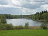 |
This restricted area protects the eutrophic Lake Istra and the biotopes that are alongside it – various kinds of forests and meadows. This is a particularly lovely part of the Latgale region. Interestingly, the so-called system of “rope farms” can still be seen in the nature park.
|
|
 |
The café, located between Talsi and Laidze, on the side of the Talsi-Upesgrīva highway (P127), offers traditional Eastern European lunch and dinner dishes. |
|
 6 days
|
On this trip you will encounter a rich blend of wetland, woodland and coastal habitats, when almost all the species have arrived and some passage migrants still remain, with the possibility to see around 200 different species. Birdwatching starts in the Gauja National Park with beautiful rolling relief, then goes to the eastern edge of the Gulf of Riga and Lake Burtnieks where there is also the chance of night trekking on the flood plains. Seda bog with its reed beds and flood plains is rich in wildlife. Next day canoeing along the Gauja river will offer a different viewpoint to see the birds, plus with luck some beaver and other wild fauna. Then you pass through oak forest to Lake Lubans. Its wetlands and fish ponds form one of the prime birdwatching sites in the country. A local speciality - fish-soup - will keep you warm. The site is also one of the first known stone-age settlements in Latvian territory. On the way back to Riga there is a stop at Garkalne pine forest. |
|
 4 days
|
Маршрут проходит по живописным природным местам Эстонии – биосферному заповеднику Моонзунда (Moonzund), национальному парку Матсалу (Matsalu) и заповеднику Вийдумяэ (Viidumäe). Маршрут включает два самых больших острова Эстонии, богатых природными и культурными памятниками – Сааремаа и Хийюмаа, - а также малые острова Муху и Касари. В маршрут включены самые интересные природные тропы (длина каждой 1-5 км), смотровые вышки и места наблюдения за птицами, биотопы, а также три поездки на пароме между островами Моонзундского архипелага. |
|
 5 days
|
Duke Jacob of Courland was a ruler of the Duchy of Courland and Zemgale for 40 years (1642-1682). There were great changes during his rule, with the ship building industry developing rapidly, the first factories appearing, and agricultural output improving. The duke had a large fleet that brought grain, meat, butter, wool, timber and all that was manufactured at baronial estates in Zemgale and Courland to Western Europe. The fleet was so big and strong that its ships sailed not just to Europe, but also all the way to Tobago and Gambia, where colonies were established to bring sugar, coffee and spices to Europe. The duchy built ships, manufactured paper and saltpetre and wove textiles, brocade and tapestries. Iron manufacturing was highly developed, and ore was imported from Sweden. This made it possible to forge nails, anchors, bells, cannons and other firearms. The duchy produced vodka, vinegar and gunpowder for which there was great demand in Europe, because there were attacks and defences that required it. As much as 25 tonnes of gunpowder were produced each year. One of the gunpowder towers is still in Kandava, though it has been rebuilt many times. The duchy manufactured sails and ropes, as well as hemp ropes. It was said that the fleet of the Queen of England would not have existed without those ropes. The duke also thought about selection of grain, bred livestock, improved land with land reclamation and tried to expand output from his fields. Jacob did not manage to do everything that he wanted to do. A canal to avoid the Venta rapids was not finished, and plans such as the colonisation of Australia were not finished. Yet the era of Duke Jacob was a period of great change in the territory of Latvia, and it has not gone unnoticed that the great achievements of the duke occurred on a small plot of European land. That proves that wise management can ensure lots of progress. |
|
 |
This village is at the place where the Irbe (Dižirve, Īra) River flows into the sea, and it is on both shores of the river (sea side and land side). The name of Irbe was recorded for the first time in a 1310 border agreement between the bishop of Kurzeme and the Rīga Dome Capitol. The name of Lielirbe (Irvemūnde) was recorded for the first time in a document from an arbitration court in 1387. At the end of the 19th century, the small port at Lielirbe was an active centre for the sale and transport of timber materials. In the late 19th and early 20th centuries, the largest number of sailing ships among villages on the western shore of Kurzeme was built there. In 1939, the village had some 300 residents, more than 70 houses and a Baptist church which is now at the Ventspils Open Air Museum. A narrow-gauge railroad passed through the village, which had a post and telegraph office, two grocery stores, an elementary school, a choir and a brass band. Lielirbe was one of the largest villages to disappear after World War II. Cultural historian Valda Marija Šuvcāne (1923-2007) was born in Lielirbe, and her daughter, Baiba Šuvcāne, is continuing her mother's work by writing important papers about life along the Livonian coastline. By 2019, a bridge is to be reinstalled across the Irbe River. |
|
 |
Ļoti skaists un ainavisks etnogrāfiskais ciems Balošas (Baluošas) ezera ziemeļu krastā, netālu no diviem iepriekš minētajiem ciemiem. Te apskatāmas interesantas un skaistas koka ēkas, kas celtas no guļbaļķiem, ar niedru vai lubiņu jumtiem un izrotātas ar dažāda veida dekoratīvajiem elementiem. Pirmo reizi rakstos Šumini minēti 1784. g. Savu vārdu ciems ieguva no kādreiz dzīvojošas ģimenes uzvārda. Kā interesantākā ir jāpiemin sena klēts. |
|
 1 day
|
Dodieties ekskursijā, lai gūtu ieskatu lauku profesijā un dzīvesveidā, kā arī iegūtu jaunus iespaidus un labu atpūtu visai klasei. Ekskursijas laikā apmeklējiet saimniecību, kuras galvenā specializācija ir piena lopkopība un graudkopība. Pēc tam izbaudiet pikniku Vilces dabas parkā, kurš ir izvietojies Vilces upītes un tās pieteku gravu krastos. Pie Vilces pilskalna atrodas Zaķu pļava – labiekārtota un iecienīta apmeklētāju atpūtas vieta. Tālāk dodieties uz maizes ceptuvi, lai iepazītos ar maizes cepšanas arodu, degustētu un iegādātos maiznīcas izstrādājumus. Ekskursijas noslēgumā apmeklējiet saimniecību, kur audzē graudaugus un kartupeļus, piedāvā apskatīt senu darba rīku un piena pārstrādes iekārtu kolekciju un praktiski darboties ar tiem. Bērni var atpūsties un pavadīt brīvo laiku atrakciju parkā. |
|
 |
This is one of few open air objects to honour the globally unique Baltic Way demonstration, during which several million residents of Lithuania, Latvia and Estonia joined hands in an unbroken chain that stretched from Tallinn all the way to Vilnius. The monument is at the former border crossing point at Unguriņi on the border between Latvia and Estonia, and it was installed on the 20th anniversary of the demonstration on August 23, 2009. It was designed by the metal artist Andris Dukurs. |
|
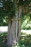 |
This is the thickest and tallest common ivy in Latvia. It is in the park of the Zentene Estate, opposite the mansion (which is now a school).
|
|
 |
Neskartu mežu cienītāji var doties izpētīt Plakanciema puses mežu takas. Braucot no Plakanciema pasta nodaļas Mellupu virzienā pa autoceļu V7, pēc aptuveni 1 km jānogriežas ceļā pa labi. Tālāk jādodas uz priekšu vēl 1,2 km. Maršruta sākums - iepretī mājām “Putriņas” ceļa kreisajā pusē, kur sākas meža ceļš. Sākumā maršruts ved pa taisnu meža ceļu. Pēc 500 m nonākam pie ūdenskrātuves (karjera). Šeit ir iespēja doties vai nu gar vienu ūdenskrātuves krastu, vai gar otru. Abās pusēs var aiziet aptuveni līdz ūdenskrātuves pusei un tad griezties atpakaļ. Krastā augošos kokus iecienījuši bebri. Ūdenī peldas pīles, meža ceļa malā vairāki skudrupūžņi, no sakritušo pērno lapu apakšas lien ārā zaķskābenes. |
|
 |
Liepājas novada zaļā produkta, kultūrvēsturiskā mantojuma, seno lauku tradīciju saglabāšana un popularizēšana pilsētvidē. |
|
 |
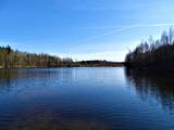
Nacionālā parka galvenā ainavas dominante. Ezers ir ~ 8,4 km garš un līdz 3,3 km plats. Tā austrumu krasti pārsvarā ir ar mežiem apauguši, ziemeļrietumu krasts – purvains, bet rietumu krastā parādās apdzīvotas sētas un simpātiskā Plateļu (Plateliai) pilsētiņa, kur meklējamas skaistākās skatu vietas. Ezera krastos ir labi attīstīta infrastruktūra - tūristu mītnes, ēdināšanas uzņēmumi (Plateļos), ūdenssporta un atpūtas inventāra noma. Ūdens dzidruma dēļ, Plateļu ezeru ir iecienījuši zemūdens niršanas entuziasti. Ezerā ir vairākas salas, no kurām interesanta ir Pils salas (Pilies sala), uz kuras no 15. – 16. gs. atradās muiža. Pastāv uzskats, ka senie Plateļu apkārtnes iedzīvotāji sākotnēji ir dzīvojuši uz salas, kuru ar krastu savienojis uz pāļiem celts tilts. Jāpiemin, ka 15 gs. pirmoreiz pieminētā Plateļu pilsētiņa atradusies uz Šventorkalņa (Šventorkalnis) kalna. Apkārt Plateļu ezeram ir izveidots ~ 24 km garš velomaršruts. Tā ir ļoti laba iespēja iepazīt parku videi un ceļotāja veselībai draudzīgā veidā. |
|
 |
This site has a commemorative stone which speaks to Krišjānis Valdemārs’ achievements in the development of the Latvian state. This used to be the location of the Roja or Lubezere maritime school, and the home for teachers is still there. A private medical practice is in the building right now. The maritime school existed from 1873 to 1915 and was wrecked during World War I. The school trained helmsmen for short-distance trips. Tuition was free, and classes were taught in Latvian. Latvian sailors were known in Russia and abroad, including the Americas. They were respected for their serious approach to their work, their honesty and their loyalty. (Source: Roja TIC) |
|
 |
The Soviet Border Guard arrived at Lapmežciems (its border with Ragaciems) in the mid-1960s and left in 1991. Some 50 military personnel were stationed here. The military personnel and local residents organised various events and celebrations. The only thing that worried locals was a radar which was said to cause various problems. The zenith missiles were dismantled and taken away in 1991. An apartment building is still on what was then the military base. |
|
 |
The aim of this territory is to regulate the natural and cultural landscapes of the upper reaches of the Daugava River valley, where there is a great deal of biological diversity. Nature trails have been installed in the park, as have bicycle routes. The river is good for boating in this area, too. The Curves of the Daugava nature park is part of the territory (see “Nature Parks”). |
|
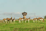 |
Te plašos aplokos mīt 38 sugu savvaļas dzīvnieki (kiangi, lāči, lūši, vilki, meža cūkas, aļņi, vāveres, plēsīgie putni) un visdažādāko šķirņu mājdzīvnieki – Latvijas zilās, Hailandes un Galovejas govis, Romanovas aitas, Vjetnamas cūkas, pīles, zosis, tītari u.c. Acīgākie dīķos pamanīs retās Eiropas kokvardes. Kalvenes pagasta „Cīruļi” – tā ir lieliska, nesteidzīga atpūta lauku vidē, iepazīstot dzīvo dabu! Darba laiks no novembra līdz martam: katru dienu no 10:00 – 16:00 |
|
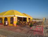 |
Beach cafe at the end of Jūrmalas Street, by the beach, in Liepāja. Live music in the Wind Garden on Wednesdays, Fridays and Saturdays. Offers breakfast, lunch, dinner, coffee and drinks. |
|
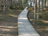 |
Plieņciema taka atrodas dabas liegumā "Plieņciema kāpa" starp Plieņciemu un Ķesterciemu. Pāri kāpai ir izveidota laipu taka un atpūtas vieta. Taka ir izveidota, lai mazinātu negatīvo ietekme uz Plieņciema kāpas dabas vērtībām – zemsedzes nomīdīšanu, piegružošanu ar atkritumiem, braukšanu ar autotransportu.
|
|
|
|
Entstanden als eine 6 km entfernte Arbeiterstadt des schon geschlossenen Ignalina-Atomkraftwerks. In der Stadtbebauung dominieren die für die Sowjetzeit typischen architektonischen Formen und Monumentalbauten. |
|


