
| No | Name | Description |
|---|---|---|
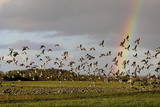 |
This is one of the most popular bird-watching locations in Estonia, and during spring and autumn migration there are a great many different kinds of birds resting and feeding in the meadows and shallow coastal waters of the Bay of Matsalu and the Kasari River.
|
|
 |
This homestead on the banks of the Rauna River breeds various kinds of fish. During the winter, you can fish for various salmon-type fish, and in the summer you can fish for sturgeon, blue-char, tilapia and trout. You can purchase fish, and tastings are available for groups of visitors. Sillakas is approximately 3 km from Liepasmuiža. |
|
 |
The air defence radar facilities at the Liepāja airport in Cimdenieki are gone now, although the man-made terrain in the area remains interesting today.
|
|
 |
Briežuciems, kas atrodas Balvu novadā, ir izveidojies pēc 2. Pasaules kara kā padomju saimniecības „Briežuciems” centrālais ciemats. Mūsdienās Briežuciema amatu meistaru ciems ir vieta, kur tiek kopti un godāti tradicionālie amati, iesaistot tos mūsdienu dzīvē. |
|
 12 days
|
The route includes some of the most authentic local expediencies travelling through blue lake districts along the Eastern part of Latvia and Lithuania. This is a region where mass tourism has not yet arrived, and you find very sincere and hospitable people, traditional villages, many churches and cult locations which bring together paganism, Roman Catholicism, Lutheranism, Russian Orthodoxy and Old believers, |
|
 |
Pareizticība Traķu apkārtnē „ienāca” jau Lietuvas dižkunigaiša Ģedimina (Gediminas) valdīšanas laikā (1316. – 1341.). Līdz 18. gs. beigām no astoņām pareizticīgo baznīcām Traķos nebija saglabājusies neviena, tādēļ pareizticīgo draudze 1863. g. uzcēla jaunu baznīcu, kas saglabājusies līdz mūsdienām un apskatāma Vitauta ielā (Vytauto gatve) 32. |
|
 |
Nacionālā parka galvenā ainavas dominante. Ezers ir ~ 8,4 km garš un līdz 3,3 km plats. Tā austrumu krasti pārsvarā ir ar mežiem apauguši, ziemeļrietumu krasts – purvains, bet rietumu krastā parādās apdzīvotas sētas un simpātiskā Plateļu (Plateliai) pilsētiņa, kur meklējamas skaistākās skatu vietas. Ezera krastos ir labi attīstīta infrastruktūra - tūristu mītnes, ēdināšanas uzņēmumi (Plateļos), ūdenssporta un atpūtas inventāra noma. Ūdens dzidruma dēļ, Plateļu ezeru ir iecienījuši zemūdens niršanas entuziasti. Ezerā ir vairākas salas, no kurām interesanta ir Pils salas (Pilies sala), uz kuras no 15. – 16. gs. atradās muiža. Pastāv uzskats, ka senie Plateļu apkārtnes iedzīvotāji sākotnēji ir dzīvojuši uz salas, kuru ar krastu savienojis uz pāļiem celts tilts. Jāpiemin, ka 15 gs. pirmoreiz pieminētā Plateļu pilsētiņa atradusies uz Šventorkalņa (Šventorkalnis) kalna. Apkārt Plateļu ezeram ir izveidots ~ 24 km garš velomaršruts. Tā ir ļoti laba iespēja iepazīt parku videi un ceļotāja veselībai draudzīgā veidā. |
|
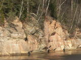 |
Boaters along the Gauja will see the Velnala cliffs, which are the last mighty wall along the banks of the Gauja River valley – approximately 15 m high. From the opposite shore of the river, where there are leisure facilities, once can spot the Krimulda Devil’s cave, which is in the centre of the cliff, is some 19 m deep, and is 4.7 m high. There were once wooden structures which allowed people to visit the cave, but that stopped in 1980 for safety reasons. If you head toward Turaida along the lower part of the basic Gauja River shoreline from the Velnala cliffs, then, particularly when the trees are bare, you will see the mighty sandstone Piķene cliff. At its foot is the Piķene beaver trail, which is approximately 1 km long. On quiet evenings, you may well spot a beaver at work. Along the path you will see the Small Devil’s cave (5 m deep) with the Wisdom Stream that flows out of it. The Aunapiere cave is almost as deep. Between the cliff and the Gauja are several small rivulets which are of enormous importance in preserving the diversity of the surrounding environment. |
|
 |
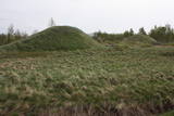
One of the highest dunes in Latvia, located between Bernāti and Jūrmalciems villages. It is 37m high and offers a magnificent view of the sea and natural pine forests. The highest dunes in Latvia stand to the South of Jūrmalciems village: the Pūsēnu hill, the Ķupu hill, the Mietragkalns or Tiesas hill, the Pāļu hill, the Garais hill, the Ātrais hill, the Lāvas hill. The Pūsēnu dune is the highest of these dunes which are all called hills by the local people. The Pūsēnu hill developed between 1785 to 1835 when shifting sand became extremely dangerous. Several homesteads were buried in sand, among them „Pūsēni”, where a forester’s family lived. The family is said to have moved to Bārta. The dune was named after the buried homestead. Jēkabs Janševskis, a Latvian writer, wrote in his book „Nīca”: “In olden times, large pine trees were growing in the dunes on the coast of Nīca and they stood steady and firm. But i Swedish times (around 1650), the Swedes built a large kiln for charcoal and tar. Pine wood and stumps provided an excellent material for this. Once a big fire rose, and the charcoal kiln burned down as well as the whole pine forest. The remaining stumps and bare trunks in the vast burnout could not hold the storm-driven sand; it flew further and further burying not only the burned-out forest, but also the nearest fields. In wintertime, when the vast, low marshy grasslands were covered with ice, jets of sand drifted further over its surface, and soon most of the grasslands and large meadows turned into sandy heath-land and dunes.” To reconstruct Liepāja, severely damaged during WWII, a silicate brick factory was built in the town. The main raw material was white sand and it was taken from the Bernātu forest. In the 1960-ies they started to dig off the Green Dune and the White Dune, later also the Pūsēnu hill. The excavators used to work day and night, in three shifts. The work stopped at around 1980, as there was no more sand suitable for production of brick. A trail is set up to facilitate walking in the Pūsēnu Dune in the Bernātu Nature Park. |
|
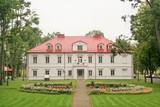 |
This is a lovely park and a reconstructed estate from the mid-19th century, located 14 km away from Panevežys in northern Lithuania. The estate was established during the latter half of the 19th century, and during the 20th century, various buildings were erected, including a two-story mansion with two floors (mid-19th century), stables, cellars, a gardener hut and ancillary buildings. The mixed-type park with ponds was installed in during the latter half of the 19th century. There was a large pergola on a hillock in the park, and it was alongside the gardener's hut. The silhouette of the park is enlivened by newly pave pathways and little bridges that link the ponds. |
|
 |
Jaunpils ūdensdzirnavas ir industriālā tūrisma apskates objekts, kurā ir saglabājusies dzirnavu iekārta, kas darbojusies 20. gs. 20.−30. gados, kā arī hidrotehniskās būves un ūdenskrātuve. Šobrīd dzirnavās ir izveidota ekspozīcija par pašām dzirnavām, malšanas procesu un graudkopību. |
|
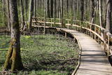 |
Uz pāļiem veidotā koku laipu taka līkumo cauri Vēršupītes dumbrājiem (pārmitri platlapju meži), tādēļ visiespaidīgākie skati šeit ir vērojami tieši pavasara palos vai citos gadalaikos pēc lielām lietavām, kad mazā upīte iziet no krastiem un appludina dumbrājus lielākā platībā. Par teritorijas sezonālu applūšanu liecina arī daudzo alkšņu resnie sakņu kakli, kas nevilšus atgādina mangrovju audzes. Mitrie meži ir viens no sugu skaita ziņā daudzveidīgākajiem Latvijas biotopiem.
|
|
 |
Vecauces ev. lut. baznīca ir valsts nozīmes arhitektūras piemineklis. Baznīca pirmo reizi uzcelta kā koka būve 1667. gadā, bet pēc zibens spēriena 1729. gadā tā nodega. Mūra baznīca celta 1744. gadā, savukārt 1866.gadā Mēdemu valdīšanas laikā baznīcu paplašināja līdz 500 sēdvietām, izgatavoja jaunu altāri, kanceli un uzstādīja Liepājas ērģeļmeistara Kārļa Hermaņa būvētas ērģeles. meklētājiem piedāvā doties interesantā, izklaidējošā un informatīvā ekskursijā pa baznīcu, apskatot ekspozīciju "Auce pirmās Latvijas brīvvalsts laikā" un baznīcas bibliotēku (Baznīcas grāmatas (pirmās Latvijas brīvvalsts laiks – 1918.-40.g., vācu laiks, padomju laiks un šodiena)). Baznīcā izveidotajā Mākslas telpā apskatei tiek piedāvātas vairākas unikālas ekspozīcijas: skolotājas Jadvigas Kupčes grāmatu un personīgo lietu ekspozīcija, kantātes “Dievs Tava zeme deg” vārdu autora Andreja Eglīša ekspozīcija, izcilā flamenko ģitārista Andreja Kārkliņa un režisora Kārļa Pamšes ekspozīcijas. |
|
 |
The cafe Baravika is situated in the centre of Rezekne city. It offers a wide variety of dishes. Working hours: Mon-Fri 8.30 līdz 18.00 |
|
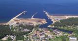 |
In the 19th century at the seaside of Skulte, a small village formed, which was inhabited by fishermen. The name “Zvejniekciems” (Fishermen’s village) arose from the population's main activity. In 1967 the Skulte part of Zvejniekciems was added to the Saulkrasti township. Nowadays Zvejniekciems is the home of Skulte Port, and the rocky beach of Zvejniekciems is located between the port and Saulkrasti Beach, while the village itself can be proud of the creative heritage left by the architect Marta Staņa (1913–1972). |
|
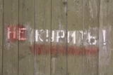 |
This extensive territory to the South of Pāvilosta once was the site of warehouses and an oil base. The territory at this time is used for the extraction of raw materials. There is also a sawmill there. The sign at the entrance of the facility states that the area can be dangerous to visitors.
|
|
 |
The farm is located near Sangaste rukikula, amidst wild nature. At the farm you can enjoy delicious food, catch fish, go to the sauna, and spend the night. Both lovers of active recreation and people simply looking for a pleasant way to spend time will find suitable activities. |
|
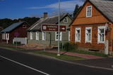 |
The central part of the town of Krāslava is an historical monument because its low-story and beautiful wooden buildings. The best views of the historical centre relate to the carp park near the Adamova trail, the Karņicskis hill, the bridge across the Daugava (Prospekta Street), and the Priedaine viewing tower on the left bank of the Daugava River. |
|
 4 days
|
Маршрут ведет вдоль обоих берегов судьбоносной реки латышей – Даугавы. В маршрут включены такие значимые места, как развалины Кокнесского замка и создаваемый «Сад Судьбы». Путешественников порадуют как чудесные виды на речные ландшафты, так и древние городища, латгальские гончарные традиции и другие мастера ремесел. Даугавпилс с предложением многообразного военно-индустриального наследия и художественным центром знаменитого художника Марка Ротко. Информация о маршруте от Latvijas Lauku forums |
|
 3 days
|
From Riga the route goes to the historic Estonian sea resort and then by ferry to Muhu island. On the way there is ethnographic village of Koguva, the Liiva church and the elegant Padaste Manor. Overnight at Muhu island. 28 km cycling there juniper fields, its small fishing villages, and the magnificent Juigu cliffs, which open up a view of the other small islands in the Monzunda archipelago. Then drive to Saaremaa and stay in Kuressare, the island's capital. There the rooute covers such attractions as Kaali meteorite crater, impressive Valjala church and castle mound, Piretikivi rock and Poide church. Cycle along the Tagameisa Peninsula, up to 30 km. Driving to the ferry take a loop along Viidumae National Park with its viewing tower, Kihelkonna Church, the Odaletsi streams and nature trail and the dolomite Panga cliffs. |
|


