
Nature objects in Estonia

What's special about the nature in Estonia?
In Estonia, there stands the most impressive rock wall in the Baltics - the so called North Estonian "glint" (from Estonian language). Estonia has its own "Land of Inlets" - the Lahemaa region with its national park, the "Land of Islands" - the Saaremaa island and the Monzund archipelago. The Matsalu bay is one of the most significant rest stops for birds during their migration. In Estonia there is one of the most prominent impact craters in Europe, there are the greatest waterfalls and boulders in the Baltics, the Munamagi hill - the highest spot in the Baltics, the Lake Peipus - the 5th largest lake in Europe, - with long-standing fishing traditions, and the great variety of nature from West to East, from North to South.
Act responsibly - follow the Green advice!
| Overview | Details |
|---|---|
 |
Estonia
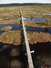
The Endla ReserveThis reserve was set up to protect local swamps and surrounding wetlands. Please note that before you can visit the reserve, you must register with the local administration and visitor centre in the village of Tooma.
ServicesServices - recreational
Nature trailThe Endla swamp trail (~2 km) with a viewing tower, and the Endla stream trail (6 km). Please note that before you can visit the reserve, you must register with the local administration and visitor centre in the village of Tooma. For more information: www.endlakaitseala.ee (available in English). |
 |
Estonia
Sõrve säärDie Südspitze der Insel Saaremaa – eine aus Geröll in der Irbenstraße langgestreckte Landzunge. Militärbefestigungen, Leuchtturm (1960), Vogelbeobachtungsort.  270 270
Services
270km - Distance from countries capital city |
 |
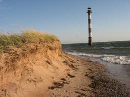
Estonia
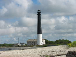
Kap TahkunaDer weiteste Nordpunkt der Insel Hiiumaa. Der höchste Leuchtturm Estlands aus Roheisen (1873 – 1875) und das Denkmal zur Errinerung an die bei dem Unglück des Schiffes ‘Estonia” Umgekommenen. 175
Services
175km - Distance from countries capital city |
 |
Estonia
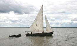
Trips aboard kaleshipsKale is a traditional wooden sailing ship for trawling nets on Lake Võrtsjärv, but its graceful appearance with two triangular sails often inspired pleasure trips too. Võrtsjärve Foundation supported the building of the ship Paula, completed in 2005 and Liisu in 2009. Trips aboard a kaleship are a genuinely memorable experience. 181
 5-9 5-9
Services
181km - Distance from countries capital city
5-9 Active season months |
 |
Estonia
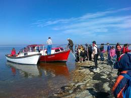
Pärimusmatkad/Heritage ToursThe company provides wildlife tours – seal watching, walking, cycling or skiing trips, rubber boat trips to Vilsandi and other islands, orchid trips, and trips to learn about culture and life of the manors, towns and villages, crafts and seafaring. Miku forest park in Vilsandi National Park is where visitors can learn about and try various forestry jobs. 200
1-12
Services
200km - Distance from countries capital city
1-12 Active season months |
 |
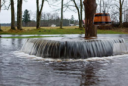
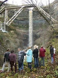
Estonia
Keila waterfallThis is one of the loveliest waterfalls in Estonia – up to 6 m in height and 50 m in width. Recommended: The rapid Keila River has carved a cliffy canyon behind the waterfall, with a flow of water that falls down a major distance. It’s worth hiking through the Keila park to the shore of the Bay of Finland (~1 km), then returning along the other bank of the river.
Services
31km - Distance from countries capital cityServices - recreational
Nature trailThe rapid Keila River has carved a cliffy canyon behind the waterfall, with a flow of water that falls down a major distance. It’s worth hiking through the Keila park to the shore of the Bay of Finland (~1 km), then returning along the other bank of the river. |
 |
Estonia
Stein MajakiviDer dritgrößte Feldstein im Baltikum (584 m3, 7 m hoch, Durchmesser bei dem Grund – 32 m ). Auf estnisch bedeutet „Hausstein”. Befindet sich am Rande des Pikanõmme – Majakivi Pfades (4,5 km lang). 60
Services
60km - Distance from countries capital city |
 |
Estonia
Vilsandi sala (Vilsandi saar)Vilsandi nacionālā parka „sirds” un divpadsmitā lielākā Igaunijas sala (garums - 6 km, platums – 2 km). Tā ir ļoti „jauna” sala, kas sākusi veidoties pirms ~ 2000 gadiem zemes garozas celšanās rezultātā, savienojoties divām salām, kas noticis pirms ~ 350 gadiem. Cilvēki salu sāka apdzīvot 18. gs. un to galvenā nodarbe bija zvejniecība, kuģu būve, nelielā apjomā – lauksaimniecība. Līdz 2. pasaules karam te bija ap 200 iedzīvotāju, kuri vēlāk salu bija spiesti pamest PRSR pierobežas režīma zonas dēļ. Nozīmīgu Vilsandi daļu aizņem mežs un kadiķu lauki. To visā garumā šķērso grantēts - zemes ceļš ar atzariem uz jūras krastu. Salu ar kājām var izstaigāt vairāku stundu laikā, iepazīstot vietējo apbūvi (daļa arī mūsdienās celtas ēkas) un Tolli sētu, kur pēc nostāstiem dzīvojis nīderlandiešu jūras braucējs Johans Dolls, kā arī vējdzirnavas. Noteikti ir jāaiziet līdz salas rietumu krastam, kur atrodas Vilsandi bāka un bākas uzrauga saimniecības ēkas. No šejienes ir labi redzamas Vaikas salas. Šodien uz salas pastāvīgi (visa gada garumā) dzīvo tikai trīs cilvēki. |
 |
Estonia
Koiva heritage culture trailThe 60 km cross-border cycling trail along the Koiva/Gauja River in Estonia and Latvia was completed in 2010. The trail begins at Tellingumäe car park, start and finish points of the trail and the border crossing site are supplied with resting areas and information boards with maps. Signposts are located at crossroads where there may be confusion for cyclists; attractions near the main route are also signposted. Information boards are provided in Estonian, Latvian and English. Tellingumäe car park is also a starting point for an 18-km cycling route. 267
1-12
Services
267km - Distance from countries capital city
1-12 Active season months |
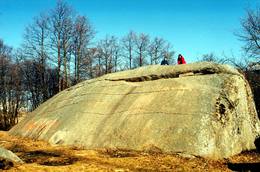 |
Estonia
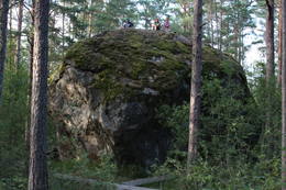
Muuga Kabelikivi rockThis is the second largest rock in the Baltic States in terms of size (728 m3). It is the only rock in the Baltic States with this form and size. It is 7 m high, 19 m long, 11 m wide, and 58 m in perimeter. Kabelikivi looks like a cliff that is halfway sunk into the earth. During the Ice Age, the rock “travelled” to this location from southern Finland. It is made of granite, and there are two other very impressive rocks alongside it.
|
 |
Estonia
Erdi taka (Öördi rada)1,2 km gara taka, kas pa purvainu mežu aizved līdz Ērdi purvam (Öördi raba) un tā austrumu daļā esošajam Ērdi ezeram (Öördi järv), pie kura izveidota atpūtas un peldvieta. |
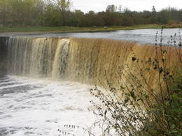 |
Estonia
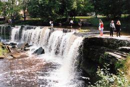
Jägala waterfallThis is one of the greatest waterfalls in the Baltic States – 8 m high and up to 70 m wide. It is most impressive in the spring and after strong rains. The waterfall and its ~300 m canyon emerged from the limestone of the Ordovician Period. You may spot some fossils there. When the water is low, courageous people try to ford the river both above and below the waterfall. The limestone and the falling water have established a unique “tunnel” there.
|
 |
Estonia
Tuhala Nature Centre and NõiakaevTuhala region has settlements of about 3000 years of age. There are 11 ancient settlement sites, 30 cult stones, 3 burial sites, 4 sacred groves, etc. Tuhala Landscape Reserve has a unique natural feature - the Nõiakaev (Witch´s Well) which “boils” up water during floods at 100 l/s, and 5 mightiest energy columns of the country. 32
1-12
Services
32km - Distance from countries capital city
1-12 Active season months |
 |
Estonia
Harilaidas pussala (Harilaid)Sāmsalas ziemeļrietumu daļā jūrā iestiepjas iespaidīgā Tagameizas pussala (Tagamõisa poolsaar). Tās ziemeļrietumu daļā meklējama mazāka – ap 5 km garā Harilaidas pussala (Harilaid). Pussalas vidusdaļā viļņojas Lajalepas ezers (Laialepa järv) - bijušais jūras līcis, kas zemes garozai ceļoties, kļuvis par iekšēju ūdenstilpi. Arī pati Harilaida (igauniski „laid” nozīmē „saliņa”) vairāk nekā trīs gadsimtus atpakaļ bijusi sala. Harilaidu iecienījuši ne tikai migrējošie putni, bet arī roņi, kurus piesaista vientuļi līči un akmeņainās sēres. Harilaidu var apmeklēt tikai ar kājām vai ar divriteni, bet spēkrati ir jāatstāj autostāvlaukumā. No tā ~ 1 km attālumā atrodas vieta, kur pēc 17. gs. radies Harilaidas savienojums ar Sāmsalu. Šeit paveras nepierasti klaja un akmeņaina ainava. Pārējā Harilaidas daļa ir apmežota pirms ~ 40 gadiem. Kopumā būs jāveic ~ 10 km garš pārgājiens. 273
Services
273km - Distance from countries capital city |
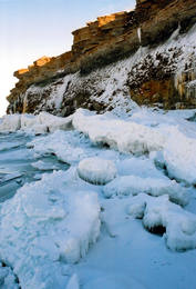 |
Estonia
Pakri peninsulaAt the end of the Pakri peninsula is the most visually impressive shoreline cliff in the Baltic States – the Pakri cliff (Pakri pank), which is as much as 24 metres high. During cold winters, streams which flow from the layers of limestone cliffs form fantastic and unusual shapes of ice.
|
 |
Estonia
Saka-Ontika-Toila-pank (cliff)This is a cliff with various levels. Known as the North Estonian cliff, it stretches all along the shore of the Bay of Rīga in Estonia, including some of the local islands. The most expressive part in geological and landscape terms is the Saka-Ontika-Toila cliff, which is around 22 km long and offers an unusual natural environment. The cliff is as much as 53 m high, and it has a fairly virginal forest along its slopes. The layers of clay, sandstone, limestone, etc., come from the Cambrian and Ordovician periods. The Valaste juga (Valaste waterfall) is 24 metres high. After a longer period of freezing temperatures, the waterfall has a particularly impressive appearance. Seasonal waterfalls (8-10 m) can be found near the villages of Ontika and Toila.
ServicesServices - recreational
Bicycle trailBike from Saka to Taoil (20 km) along the road that is at the top of the cliffs.
Nature trailHike along the seashore during the season when trees are bare, moving from Saka to Toila (~22 km). 
Nature watchingThere is an impressive viewing platform at the Valaste waterfall. |
 |
Estonia
Viking villageA unique theme park on the River Pirita evokes interest in ancient Vikings. Facilities include: stronghold, chamber of spells, smithy, Viking boat and dugout canoe trips, shows and battles with ancient weapons, a catapult, archery, axe throwing, cave and smoke saunas, trout fishing, accommodation, catering etc.  30
1-12
30
1-12
Services
30km - Distance from countries capital city
1-12 Active season months |


