
Nature objects in Estonia

What's special about the nature in Estonia?
In Estonia, there stands the most impressive rock wall in the Baltics - the so called North Estonian "glint" (from Estonian language). Estonia has its own "Land of Inlets" - the Lahemaa region with its national park, the "Land of Islands" - the Saaremaa island and the Monzund archipelago. The Matsalu bay is one of the most significant rest stops for birds during their migration. In Estonia there is one of the most prominent impact craters in Europe, there are the greatest waterfalls and boulders in the Baltics, the Munamagi hill - the highest spot in the Baltics, the Lake Peipus - the 5th largest lake in Europe, - with long-standing fishing traditions, and the great variety of nature from West to East, from North to South.
Act responsibly - follow the Green advice!
| Overview | Details |
|---|---|
 |
Estonia
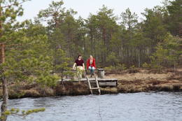
Putnu verosanas tornis Puises ragaPuises ragā (Puise nina) ir uzcelts divstāvīgs atpūtas nams, kas apvienots ar putnu vērošanas torni. No tā paveras skats uz piekrasti, kas ir iecienīta migrējošo zosu atpūtas vieta. Šī ir privāta teritorija, kuras apskati vēlams saskaņot ar īpašnieku.  123 123
Services
123km - Distance from countries capital city |
 |
Estonia
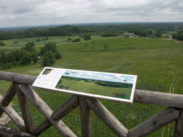
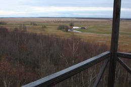
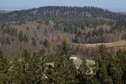
Torna kalns (Tornimägi)Karulas augstienes augstākais reljefa punkts (137 m.vjl.), kas virs tuvākās apkārtnes paceļas par ~ 60 m. Torņa kalnā ir uzbūvēts skatu tornis ar ļoti plašu apkārtskatu. Uz tā platformas ir novietoti panorāmas fotoattēli, kuros atzīmēti zīmīgākie plašākā apkaimē redzamie objekti – apdzīvotas vietas, pilskalni, baznīcu torņi u.c. Turpat izveidota atpūtas vieta un meklējams Rebases ainavu takas sākums. 260
Services
260km - Distance from countries capital city |
 |
Estonia
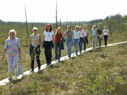
Lemmje pargajienu taka (Lemmjõe matkarada)Taka, kas izveidota Lemmjegi (Lemmjõgi) un Raudnas (Raudna jõgi) satekas vietā, iepazīstina ar palieņu pļavām un veciem pārmitriem mežiem, kas ir vieni no lielākajiem Igaunijā. Takas sākumā dominē atklātas lauku ainavas. Viens no 4,9 km garās lokveida takas apskates objektiem ir Lemjē dižozols. Mitrā laikā noderēs ūdensizturīgi apavi. 155
Services
155km - Distance from countries capital city |
 |
Estonia
Ehijervs (Ähijärv)Karulas nacionālā parka lielākais ezers - 2,8 km garš, līdz 1 km plats. Ezera ziemeļaustrumu krastā atrodas parka apmeklētāju centrs. 5,5 m dziļais ezers ir gan zivīm, gan nostāstiem bagāta vieta. Ezera un tuvākās apkārtnes iepazīšanas nolūkā ir izveidota 3,5 km garā Ehijerva taka (Ähijärve teerada). Tās sākums atrodas pie iepriekš minētā apmeklētāju centra, kur izveidota atpūtas vieta un atraktīvs bērnu spēļu laukums. Taka sākumā ved gar ezera krastu, nelieliem mitrājiem un meža ceļiem, kas izmantoti iepriekšējos gadsimtos. |
 |
Estonia
Suitsu tornis (Suitsu torn)Suitsu tornis celts 1979. g. kā pirmais Matsalu rezervāta metāla tornis. To atjaunoja 1998. g. Torņa augstums ir 21 m, tādēļ no tā paveras izcila dabas un kultūrainava uz Kazari deltas niedrājiem un blakus esošo Suitsu upi (Suitsu jõgi), kuras krastā ir uzceltas vairākas zvejnieku laivu būdas. |
 |
Estonia
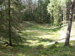
The Ilumetsa meteor cratersThere are three craters here, and the biggest one, known locally as Põrguhaud, or Grave of Hell, has a diameter of 80 m and a depth of up to 12 m. There are barriers around the crater that are several metres high. The other two craters are hard to spot. The craters around 6,000 years old. No scraps of the supposed meteorite have been found, however, and so the origins of the craters cannot be confirmed with certainty.
ServicesServices - recreational
Nature trailThe trail to the Põrguhaud crater is around 700 metres in length. For more information: http://www.ut.ee/BGGM/vaatamis/ilumetsa.html (only in Estonian). |
 |
Estonia
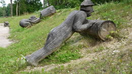
Theme park of GothamitesThe theme park of wise men of Gotham (Kilpla) is located in Müüsleri village; the park’s attractions arise from legends told in Germany some 400 years ago. Gothamites are funny characters famous for their irrational, impractical and foolish actions. Fun-packed tours and activities are on offer along with craft workshops, themed souvenirs, catering (groups should book in advance), and grounds for pitching tents. 107
 1-12 1-12
Services
107km - Distance from countries capital city
1-12 Active season months |
 |
Estonia
Harilaidas pussala (Harilaid)Sāmsalas ziemeļrietumu daļā jūrā iestiepjas iespaidīgā Tagameizas pussala (Tagamõisa poolsaar). Tās ziemeļrietumu daļā meklējama mazāka – ap 5 km garā Harilaidas pussala (Harilaid). Pussalas vidusdaļā viļņojas Lajalepas ezers (Laialepa järv) - bijušais jūras līcis, kas zemes garozai ceļoties, kļuvis par iekšēju ūdenstilpi. Arī pati Harilaida (igauniski „laid” nozīmē „saliņa”) vairāk nekā trīs gadsimtus atpakaļ bijusi sala. Harilaidu iecienījuši ne tikai migrējošie putni, bet arī roņi, kurus piesaista vientuļi līči un akmeņainās sēres. Harilaidu var apmeklēt tikai ar kājām vai ar divriteni, bet spēkrati ir jāatstāj autostāvlaukumā. No tā ~ 1 km attālumā atrodas vieta, kur pēc 17. gs. radies Harilaidas savienojums ar Sāmsalu. Šeit paveras nepierasti klaja un akmeņaina ainava. Pārējā Harilaidas daļa ir apmežota pirms ~ 40 gadiem. Kopumā būs jāveic ~ 10 km garš pārgājiens. 273
Services
273km - Distance from countries capital city |
|
|
Estonia
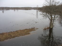
Klostri (Kloostri) skatu tornisMetāla tornis Kazari upes kreisajā krastā, ~ 5 km attālumā no Matsalu līča. No torņa redzamās Kazari deltas palieņu pļavas atrodas tikai 0,3 – 1 m augstumā virs jūras līmeņa, tādēļ pavasara palos un stipru vētru (īpaši rietumvēju) laikā ūdens appludina milzīgu teritoriju. Uzskata, ka platības ziņā šīs ir vienas no lielākajām Eiropas palieņu pļavām, kas ir nozīmīga dažādu tārtiņveidīgo putnu sugu ligzdošanas, dzērvju un zosveidīgo putnu atpūtas un barošanās vieta. Ir pagājis laiks, kad zemnieki Matsalu pļavās ganīja govis un pļāva sienu, tādēļ šobrīd pļavu apsaimniekošanu veic nacionālā parka administrācija. |
 |
Estonia
Moorpfad ViruEin 3,5 km langer Pfad quert den Viru Moos in Richtung Süd–Nord. Von einem Holzaussichtsturm eröffnet sich einen Blick auf eine typische Hochmoorlandschaft mit einigen Seen, Aushöhlungen und morastigen Stellen. 56
Services
56km - Distance from countries capital city |
 |
Estonia
Perajerva meza taka (Pärajärve metsarada)Četrus kilometrus gara marķēta lokveida taka, kas ved pa lielāku meža masīvu, iepazīstina ne tikai ar augiem un dzīvniekiem, bet arī mežsaimniecības tradīcijām. Takas sākums atrodas pie nelielā Perejerves ciema, uz kuru paveras labs skats no tuvējā paugura. Pie autostāvlaukuma izveidota atpūtas un piknika vieta. |
 |
Estonia
Vilsandi sala (Vilsandi saar)Vilsandi nacionālā parka „sirds” un divpadsmitā lielākā Igaunijas sala (garums - 6 km, platums – 2 km). Tā ir ļoti „jauna” sala, kas sākusi veidoties pirms ~ 2000 gadiem zemes garozas celšanās rezultātā, savienojoties divām salām, kas noticis pirms ~ 350 gadiem. Cilvēki salu sāka apdzīvot 18. gs. un to galvenā nodarbe bija zvejniecība, kuģu būve, nelielā apjomā – lauksaimniecība. Līdz 2. pasaules karam te bija ap 200 iedzīvotāju, kuri vēlāk salu bija spiesti pamest PRSR pierobežas režīma zonas dēļ. Nozīmīgu Vilsandi daļu aizņem mežs un kadiķu lauki. To visā garumā šķērso grantēts - zemes ceļš ar atzariem uz jūras krastu. Salu ar kājām var izstaigāt vairāku stundu laikā, iepazīstot vietējo apbūvi (daļa arī mūsdienās celtas ēkas) un Tolli sētu, kur pēc nostāstiem dzīvojis nīderlandiešu jūras braucējs Johans Dolls, kā arī vējdzirnavas. Noteikti ir jāaiziet līdz salas rietumu krastam, kur atrodas Vilsandi bāka un bākas uzrauga saimniecības ēkas. No šejienes ir labi redzamas Vaikas salas. Šodien uz salas pastāvīgi (visa gada garumā) dzīvo tikai trīs cilvēki. |
 |
Estonia
Mekonnu skatu tornis (Mäekonnu vaatetorn)Viens no diviem nacionālā parka skatu torņiem, kas atrodas ~ 1,5 km ziemeļos no Ehijerva ezera (Ähijärv). Tornis ir veiksmīgi „nomaskēts” nelielā priežu pudurī, tādēļ tas „nebojā” izcilo dabas un kultūrainavu, kas paveras no tā skatu platformas. Pie autostāvlaukuma ir izveidota labiekārtota atpūtas vieta. |
|
|
Estonia
Anhöhe OtepääOne of the three highlands of Southern Estonia with scenic hills and beautiful sights. In its center lies the bay-rich Lake Pühajärv (translating from Estonian - Holy Lake). 230
Services
230km - Distance from countries capital city |
 |
Estonia
Eldas klints (Elda pank) un pussalaNacionālā parka dienvidrietumdaļā jūrā iestiepjas Eldas pussala – skaists un ļoti omaļš ar kadiķu mežu (alvāriem) noaudzis zemes pleķītis ar interesantu jūras krastu, kur atsedzas silūra perioda nogulumieži. No pussalas gala, kurā slejas vecs Padomju armijas robežsargu tornis (apmeklējumam bīstams!), paveras visaptverošs skats uz Vilsandi salu (atpazīstama pēc bākas), Lonalaidas salu (Loonalaid) – otru lielāko Vilsandi arhipelāgā, Salavu (Salava) un citām mazākām saliņām. Dabas mīļotāji var uzmeklēt Eldas klinti (Elda pank) – ~ 2 m augstu un 0,4 km garu atsegumu, kura piekājē var atrast interesantas ūdens izskalotas fosilijas. 261
Services
261km - Distance from countries capital city |
 |
Estonia
The Otepää Nature ParkThis park is found in the Otepää highlands and offers an outstanding example of how the terrain of a protected natural territory can be used for recreation, sports and active leisure. The infrastructure of the park is perfect for such activities and is of a high level of quality.
ServicesServices - recreational
Cross-country skiingDuring the winter, you can ski the 63-km Tartu marathon trail, which crosses the park. 
Bicycle trailBike around Lake Pühajärv from the centre of Otepää (~20 km), or ride from Otepää to Kääriku (11 km).
Nature trailHike around Lake Pühajärv (12 km), hike the Kekkose hiking route (14 km), or hike the Murrumetsa hiking trail (3.5 km). Bike around Lake Pühajärv from the centre of Otepää (~20 km), or ride from Otepää to Kääriku (11 km). 
Nature watchingThere are viewing towers at Harimägi and in the hills of Kuutsemägi, near the Otepää ski jump, at Väike Munamägi, and near the Otepää castle hill. For more information: www.otepaaloodus.ee (available in English). |
|
|
Estonia
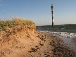
Insel HiiumaaDie zweitgrößte Insel Estlands mit breiter Waldung, Sand- und Steinstränden und einem der ältesten Leuchttürme Europas. 132
Services
132km - Distance from countries capital city |
 |
Estonia
LuitemaaThe word “Luitemaa” means “land of the dunes” in Estoninan. This coastline territory stretches for 13 km between Vöiste and Häädemeste with shallow waters, large coastal plains, Estonia’s highest dunes, and the Tokuse swamp (Tokuse raba). There are lots of birds here.
|
|
|
Estonia
Castle Hill OtepääVery expressive form of relief with wide look over the neighborhood. On its peak there's ruins of the castle of bishop Hermanis which was built in 1224. The world's oldest firearm was found here. 225
Services
225km - Distance from countries capital city |
 |
Estonia
Erdi taka (Öördi rada)1,2 km gara taka, kas pa purvainu mežu aizved līdz Ērdi purvam (Öördi raba) un tā austrumu daļā esošajam Ērdi ezeram (Öördi järv), pie kura izveidota atpūtas un peldvieta. |
 |
Estonia
The Haanja Nature ParkThis park was set up to protect the landscape and cultural environment of the Haanja highland. At the central part of the park are the two highest hills in the Baltic States – Suur Munamägi, which stands 318 m above sea level, and Vällamägi, which is 304 m above sea level. The ancient Rõuge River valley (Rõuge ürgorg) is found in the western part of the park. It is 7.5 km long and up to 60 m deep. The valley dates back to the Ice Age, and it has seven lakes, including the deepest one (38 m) in Estonia – Lake Rõuge Suurjärv.
ServicesServices - recreational
Bicycle trailBike the route Rõuge-Nursi-Tindi-Rõuge (15 km).
Nature trailThe Vällamäe nature trail (2.2 km) is the highest trail in terms of elevation in the Baltic States. You may hike the wooden trail of the Hinni canyon and the hiking route of the Rõuge River valley (10 km), or the trail of Lake Kavadi (Kavadi järv) (4.5 km).
Nature watchingThere are viewing towers at Suur Munamägi and on the eastern shore of Rõuge Suurjärv. For more information: www.haanjapark.ee (only in Estonian). |
 |
Estonia
Meenikunno swampThis is a highland swamp with several little lakes. At the SE of the area is a wooden trail.
|
 |
Estonia
Oksas (Oksa) takaBijušā piecstāvīgā metāla skatu torņa apkaimē plešas Lemmjegi upes palieņu pļavas. Netālu atrodas kādreizējā Oksas kroga (Oksa kõrts) vieta, kur saglabājies iespaidīgs manteļskurstenis. Apkaimes apskatei izveidota 0,8 km gara koka laipu taka. 175
Services
175km - Distance from countries capital city |
|
|
Estonia
Kap TahkunaDer weiteste Nordpunkt der Insel Hiiumaa. Der höchste Leuchtturm Estlands aus Roheisen (1873 – 1875) und das Denkmal zur Errinerung an die bei dem Unglück des Schiffes ‘Estonia” Umgekommenen. 175
Services
175km - Distance from countries capital city |
 |
Estonia
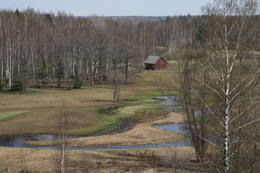
Leti tornis (Läti torn)Jēsū – Kepu ceļa malā pie Leti (Läti) ciema ir izveidots autostāvlaukums ar putnu vērošanas torni, no kura paveras skats uz Hallistes upes palieņu pļavām un tuvējā ciema apkārtni. Stipru palu laikā arī no šī torņa redzamā apkārtne (izņemot ceļus) var atrasties zem ūdens. Laba putnu vērošanas vieta. Läti tulkojumā no igauņu valodas nozīmē Latvija. |
 |
Estonia
The blue streams of SaulaThree little lakes can be found on the left bank of the Pirita River with many erupting “eyes” of streams, each with its own colour (bluish-green, white, dark). This puts together various colour combinations. These are often known as the most beautiful streams in Estonia. Some pump out as much as 20-30 litres of water per hour. It is said that the waters are good medical resources, particularly for the eyes. There are improvements in the area of tourists.
|
 |
Estonia
Nemmeveski udenskritums (Nõmmeveski juga)No vairākiem parka ūdenskritumiem noteikti ir jāapmeklē divi. 1,2 m augstais vienpakāpes Nemmeveski ir izveidojies uz Valgejegi upes (Valgejõgi), vietā kur tā šķērso Ziemeļigaunijas glintu. Šeit Valgejegi atgādina krāčainu (īpaši – pavasaros) kalnu upi, kas plūst pa vairākus metrus augstu klinšu ieskautu kanjonu. Palu laikā šo upes posmu ir iecienījuši ekstrēmie ūdenssporta veidu cienītāji. Pie ūdenskrituma un tālāk pa upi lejup redzamas ap 1920. g. celtās hidroelektrostacijas konstrukciju paliekas. |
 |
Estonia
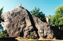
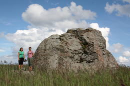
The Rock of Jana - TomaThe Rock of Jana - Toma is claiming itself to be the highest (almost 8 m) rock in The Baltic. It is located in Kasispea village. 72
Services
72km - Distance from countries capital city |
 |
Estonia
Aegna IslandThis is an entirely forested island in the Bay of Finland, ~14 km from Tallinn. A network of small pathways covers the entire island. Recommended hike along the seashore of the island, which will offer dunes, as well as a coastline that is sandy in some parts, rocky in others, and covered with reeds in still others (~9 km). A ferry boat will take you to the island from the Pirita port.
|
 |
Estonia
Halbinsel PärispeaAuf der Küste der Halbinsel befinden sich sowohl ehemalige Fischerdörfer, als auch die Reste eines Militärstützpunkts der Sowjetarmee. Großartige von den Gletschern des Eiszeitalters eingebrachte Feldsteine. 74
Services
74km - Distance from countries capital city |


