
| Nr | Nosaukums | Apraksts |
|---|---|---|
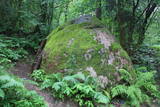 |
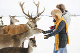
200 m attālumā no Gulbenes – Madonas ceļa mežainā nogāzē iegūlis 2,4 m augstais akmens. Tā lēzenajā virsmā iekalta ap metru gara, 0,3 m plata un ap 4 cm dziļa iedobe, bet akmens šķautnē - pakāpieni. Uzskata, ka šis ir sens kultakmens, pie kura ziedots. Lai nokļūtu līdz akmenim, vasaras otrajā pusē var nākties brist pa garu zāli. |
|
 |
Liellaiva ir speciāli Peipusa un Emajegi apstākļiem pielāgots viduslaiku preču burinieks, kādi bija pazīstami jau 14. gadsimtā. 2006. gadā pēc piecdesmit gadu ilga pārtraukuma Emajegi ūdeņos atkal tika nolaista šāda liellaiva ar nosaukumu "Jõmmu". Liellaivu biedrība (Emajõe Lodjaselts) rīko dažādus izbraucienus un dabas tūrisma pasākumus pa upi un Peipusa ezeru. Uz "Jõmmu" klāja tiek gaidīti arī mazie laivu draugi, lai iepazītos ar seniem rokdarbiem un laivu būvēšanu. |
|
|
|
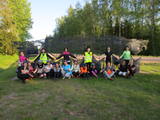
Atrodas sporta un atpūtas kompleksā „Trīssaliņas”. No torņa paveras pievilcīga apkaimes ainava, kas īpaši skaista ir pieneņu ziedēšanas laikā. |
|
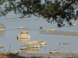 |
„Rīgas jūras līča rietumu piekraste” - nozīmīga patvēruma un barošanās vieta lielam skaitam migrējošo putnu sugu visa gada garumā. Biežāk sastopamās aizsargājamās putnu sugas – brūnkakla un melnkakla gārgale, jūrmalas dižpīle, kākaulis, tumšā pīle un mazais ķīris, teritorija ir nozīmīga arī rifu aizsardzībai. Teritorija atrodas iepretim Dundagas, Rojas un Engures novadam, kā arī Jūrmalas pilsētai, tās platība ir 132 173 ha. Teritorija ietver dabas parka „Engure” un Ķemeru nacionālā parka jūras daļu.
|
|
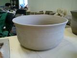 |
Amatniecības centrā, kas atrodas bijušās Svētes muižas teritorijā, organizē radošās darbnīcas. Te var iegādāties jau gatavus keramikas izstrādājumus, gan veikt individuālos pasūtījumus. |
|
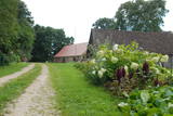 |
Nomaļa vieta pašā Latvijas – Lietuvas pierobežā – 5 km dienvidrietumos no Neretas, kur vēstures mīļiem noteikti ir vērts aizdoties. Kādēļ? Viens no iemesliem ir fakts, ka muižas graudu kalte (pamazām tiek atjaunota) un graudu žāvēšanas krāsns (daļa no vecajām koka daļām vēl ir saglabājusies) ir vienīgā tāda Latvijā. No muižas kompleksa palicis ir arī stallis un kalpu māja, kas tagad tiek apdzīvota. Ēkas celtas 18. gs. Saimnieks zina stāstīt interesantus atgadījumus, kas saistīti ar šīs vietas vēsturi. |
|
 |
Saaremaa salas saimniecībā Epi ražo augļu un ogu kečupus, dažādus ievārījumus, audzē garšaugus un tējas. Produkti tiek gatavoti tikai no vietējām – Saaremaa un Muhu salas – izejvielām. Produktus var nopirkt tieši no saimniecības. |
|
 |
Viens no retajiem brīvdabas objektiem, kas liecina par pasaules mērogā unikālo Baltijas ceļu, kur rokās un vienā ķēdē sadevās trīs valstu – Lietuvas, Latvijas un Igaunijas iedzīvotāji. Piemineklis atrodas pie bijušā Unguriņu robežas pārejas punkta pie Latvijas – Igaunijas robežas. Uzstādīts 2009. gada 23. augustā, Baltijas ceļa 20. gadadienā. To veidojis metālmākslinieks Andris Dukurs. |
|
 |
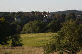
Apvidus veidots, lai saglabātu Alūksnes augstienes augstākās un izteiktākās daļas dabas un kultūras ainavu, ko veido augstākie pauguri – Dēliņkalns, Dieva kalns, Saules kalns, Drusku pilskalns un Kornetu – Peļļu subglaciālā iegultne (šeit redzama viena no lielākajām reljefa starpībām Latvijā) ar Pilskalna, Dzērves, Ievas, Raipala u.c. ezeriem, kā arī nozīmīgi biotopi – nogāžu un gravu meži, dažāda tipa purvi, pļavas, mitrie meži un tajos mītošās sugas. Teritorijā izveidotas dabas takas, distanču un kalnu slēpošanas maršruti, kā arī lokāli velomaršruti. Aizsargājamo ainavu apvidū ietilpst arī trīs dabas liegumi: Korneti – Peļļi, Avotu mežs un Dēliņkalns. |
|
 |
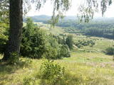
No Mālkalna (atrodas Tukumā, Jelgavas ielas malā) - Slocenes upītes ielejas krasta nogāzes augstākās vietas paveras plašs skats uz Slocenes ieleju un Tukuma pilsētu ar tās vēsturisko centru ielejas otrā krastā. Interesants skats uz apgaismoto pilsētu. Piemineklis Tukuma atbrīvotājiem.
|
|
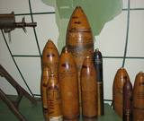 |
Muzejs atrodas Pulvertornī, kas viduslaiku Rīgā bija nozīmīga pilsētas fortifikācijas sistēmas sastāvdaļa. Muzeja pamattēma ir Latvijas militāri – politiskā vēsture un ar to saistītie eksponāti.
|
|
 |
Darbnīcā top brīnišķīga Latgales keramika. Apmeklētāji var noskatīties podniecībai veltītu videofilmu, kurā uzskatāmi parādīts, kā no māla pikas top trauks. Ekskursija, iespēja darboties pašiem un gatavo darbu iegāde. |
|
 |
„Lācīši” meklējami Galgauskas pagastā, kas atrodas dienvidrietumos no Gulbenes. Saimniecības, kas ir viena no lielākajām Vidzemes ziemeļaustrumu daļā, specializācija ir graudaugi (577 ha), rapši (295 ha) un dažādu zālāju sēklaudzēšana. Otrs saimniecības darbības virziens ir piena lopkopība (ap 100 govis), gaļas lopkopība un jaunlopu audzēšana. Izveidota interesanta apspriežu – prezentāciju telpa, kas apvienota ar govju kūti (darbība kūtī vērojama cauri lieliem stikla logiem). Aktīvi iesaistās ES projektu apguvē. Iepriekš piesakoties, iespējama saimniecības apskate un pieredzes apmaiņa. |
|
 |
„Ilzenberga muiža” – pirmā un Baltijā lielākā saimniecība muižā. Saimniecībā, kurā darbs noris harmonijā ar dabu, var redzēt un iegādāties dažādu veidu maizi no dabīgā ierauga, mājputnus un to olas, ekoloģiskās ganībās izaudzēto liellopu gaļu, pienu un to produktus, dīķos audzētās zivis, tradicionāli audzētās dārza veltes, dažādus dārzeņus, ekoloģiskajā muižas apkārtnē iegūto bišu medu, kā arī dažādus žāvētus, skābētus un kūpinātus produktus. |
|
 |
„Barono vila” – paradīzes stūrītis, kurā ir plašs un dziļš zivju dīķis, brieži un dambrieži, kas ganās iežogotos aplokos, aitas, sēņu un ogu bagāti meži, dzidri ezeri un tūristu iecienītie Sventājas upes loki. Viesu nama restorānā tiek pasniegts svaigs, garšīgs un kvalitatīvs ēdiens, izsmalcināti brieža, dambrieža un aitas gaļas ēdieni, krāsnī cepta lietuviešu rudzu maize un uz ugunskura gatavots firmas ēdiens „Barona plovs”. |
|
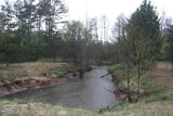 |
Dabas liegums atrodas dienvidos no bijušā Ventspils – Liepājas dzelzceļa un ietver Užavas upi (t.sk. vecupes un veco meliorācijas sistēmu) ieskaujošās pļavas aptuveni 6 kilometru garumā, kas padomju laikā tika izmantotas kā kolhoza lauki (dažādas lauksaimniecības kultūras, siens), bet tagad pamazām aizaug ar krūmāju (nepieciešama regulāra pļaušana). Aizsargājamās vērtības – retas putnu sugas, t.sk. griezes, dažādi pļavu biotopi un augu sugas. Teritorija nav piemērota tūrisma aktivitātēm. Pietiekami labs priekšstats par Užavas augšteci rodas arī to vērojot „no malas” – no Alsungas - Bērzkalnu ceļa, kura malā pie Užavas upes izveidots informācijas stends. No tā pārskatāma lieguma ziemeļu daļa.
|
|
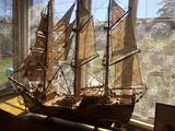 |
Vēl pirms 20 - 30 gadiem Rojā dzīvoja Laimonis un Ilga Veidemaņi, kuri bija nedzirdīgi cilvēki un ar lielu mīlestību veidoja dažāda lieluma buru kuģu modeļus. Buru kuģu modeļu veidošanas pamatā bija neizsapņotais sapnis par lielajiem sentēvu kuģiem un plašajām jūrām, kuras nebūs lemts izkuģot. Buru kuģu modeļi tika darināti ar lielu precizitāti, rūpību un mīlestību, nekur nemācoties kuģu modeļu gatavošanas noslēpumus. Buru kuģu kolekciju tagad mantojusi Laimoņa Veidemaņa mazmeita, kura vēlas brīnišķīgo kolekciju un vectēva rūpīgo darbu parādīt plašākai publikai. Mājas saimniece apmeklētājus sagaidīs un pastāstīs savu stāstu par to, kā tapa kuģi. (Avots: Rojas TIC) |
|
 |
Atrodas Madonas centrā pie Mīlestības gravas. Piedāvā maltītes visām ēdienreizēm, ekonomiskais pusdienu piedāvājums. Vasarās – āra terase. Beķereja, smalkmaizītes. |
|
 |
„Lazdiņi” – viena no Latvijas modernākajām saimniecībām, atrodas Zemgales līdzenuma ziemeļrietumu daļā, Krimūnu pagastā. Saimniecībā orientējusies uz graudaugu (ap 1100 ha) audzēšanu, pirmapstrādi un uzglabāšanu. Tās saimnieks Juris Lazdiņš ir Latvijā lielākās lauksaimnieku nevalstiskās organizācijas vadītājs. Iepriekš piesakoties, uz saimniecību lauksaimniecības profesionāļi un topošie eksperti var doties pieredzes apmaiņā. Apkaimē paveras tipiska Zemgales līdzenuma ainava. |
|
|
|
Starp steķiem un Tūjas ķieģeļu fabriku bija
izveidots sliežu ceļš, pa kuru transportēja labākās kvalitātes ķieģeļus.
Pēckara gados „Dzeņu” krastā uzcēla zivju pārstrādes rūpnīcu, bet pāri
steķiem – cauruli, pa kuru ar ventilatora palīdzību sūknēja zivis no kuģiem,
kas bija piestājuši steķu galā.
|
|


