
| Нo | Название | Описание |
|---|---|---|
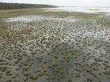 |
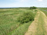
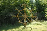
The tower on the eastern shore of Lake Engure (next to the meadow for wild cattle, accessible from the side of Bērzciems) offers a view of the reeds, small islands, Great Island, cows and horses of the north-eastern part of the lake. The tower on the northern shore of the lake (accessible from the side of Mērsrags) offers a look at the boating facility and the very overgrown northern part of the lake. The tower at the north-western shore of the lake (accessible from the side of Ķūļciems) shows the Apaļrova island (a footpath), stands of juniper, the boating facility, and the mosaic-like landscape of the lake itself.
|
|
 |
No ģeogrāfiskā un kultūrvēsturiskā viedokļa interesanta teritorija Latgales augstienes Rāznavas paugurainē, kuras nozīmīgākie resursi ir dažāda veida biotopi, ainavas, reljefs un Šķaunes ezers. Istras pauguraines dabas parkā nav ar tūrismu saistīti labiekārtojumi, bet šo teritoriju var apskatīt arī „no malas”, braucot pa grantēto ceļu no Soboļinas uz Osinovku, kas iet līdztekus parka ziemeļu robežai (skats uz Šķaunes ezeru).
|
|
 |
The nature trail was built in 2003 supported by the WWF, the Latvian Environment Protection Fund, the International volunteering organization supporting conservation initiatives in the United Kingdom (BTCV) involving volunteers from Nīca and Rucava municipal parishes. The trail exposes the surrounding landscapes and related biotopes – dunes, forest, grasslands and bog, as well as bird and animal species found there. On the trail, there is a bird watching tower and two birdwatcher hides. You can see the rivers Paurupe and Līgupe, beaver activity areas, grasslands, black alder forest, spruce forest, floodland, wild horses, aurochs, the Šķilu lime tree, the Holy Grove, the Ezerskolas sacrificial stone, the Pape ornithological field station, the Papes polder grasslands and the Pape lighthouse. There are resting places en route. The trail leads through the historical Ķoņu village with the traditional coastal fishing village architecture of buildings and yards. The trail is 9 km (5 km one way by a gravel road, returning 4km along the coastline). The trail is in the Pape nature park
|
|
 |
Established: 1931. The arboretum was set up at the suggestion of Latvia’s distinguished author Anna Brigadere. After her death and until 1935, the arboretum was supported and expanded by book publisher Jānis Rapa. There are some 180 foreign trees and shrubs of various kinds here. Some of the plants are outside the arboretum itself.
Unique plants: The Bunge’s Ash (Fraxinus chinensis), the Eastern Black Walnut (Juglans nigra), the American Buckeye (Aesculus glabra), the Smoketree (Cotinus coggyria), the White Mulberry (Morus Alba), and the Kentucky Yellowwood (Cladrastis kentukea).
|
|
 |
The Nemuna River divides up into two large streams at its estuary at Kuršių Marios, and this has established the Rusnė Island. This is a unique environmental territory with wetlands, streams, ancient rivers, lagoon lakes and flood plains which are important places for birds to nest and rest during migration season. Vast tracts of this territory are flooded each spring. The park includes the territory to the N and W of Rusne (lagoons, swamps, fishing ponds, Kuršių Marios).
|
|
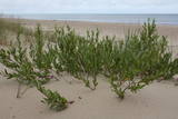 |
The territory is established in order to protect the dunes and the seashore habitats. There are beautiful beaches and wooded dunes, and the paved Klaipēda–Palanga bikeway trails through the park, which is worth travelling at full length. |
|
 |
Ar mežiem, purviem un ezeriem (Riču, Sila u.c.) bagāta teritorija Latvijas - Baltkrievijas pierobežā. Galvenās aizsargājamās dabas vērtības - dažāda veida purvu, mežu un ezeru biotopi un tajos mītošās augu un dzīvnieku sugas. Ezeru krastos, kurus iecienījuši vietējie atpūtnieki, atrodas vairākas naktsmītnes. Ilgas muiža (celta 19. gs. kā medību pils) ir Daugavpils Universitātes studentu prakses vieta. Silenes dabas parkā ietilpst arī Glušonkas purva un Ilgas dabas liegumi.
|
|
 |
Kauņas jūras reģionālais parks (Kauno marių regioninis parkas) dibināts 1992. gadā. Tas ietver Nemunas HES uzpludināto posmu – lielāko Lietuvas ūdenskrātuvi no Kauņas līdz Piļonas (Piliuona) ciemam. Viena no nozīmīgākajām parka vērtībām ir ainava, kas veidojusies ilgā cilvēka un dabas mijiedarbībā. Parkā konstatētas 950 augu sugas, 600 dzīvnieku, t.sk. - 34 zivju sugas. Parka nozīmīgas dabas vērtības ir meži, augstie purvi, kadiķu audze. Parkā ir apskatāmi dažādu vēsturisko periodu liecinieki – senču pilskalni, Pažaislis klosteris, Kauņas cietokšņa Piektais forts, kā arī Rumšišķes (Rumšiškės) brīvdabas muzejs – viens no lielākajiem (195 ha) šāda veida muzejiem Eiropā. Vaišvīdavā (Vaišvydava) ir izveidots parka apmeklētāju centrs, parkā ir dabas takas, piemēram, Žiegždriai ģeoloģiskā taka un Dubravos izziņas taka. |
|
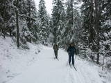 |
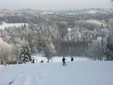
The nature park near the town of Ogre is a popular place for leisure, hiking and, in the winter, cross-country skiing. Most of the park is covered with coniferous trees that are on a long and comparatively narrow line of hillocks with steep sides – another element of nature left behind in Latvia by the Ice Age. Many different plants can be found here. The Jaunogres castle hill is one of the most distinct hillocks in the area. |
|
 |
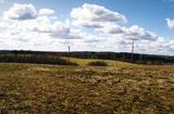
Gaiziņkalns Hill is the highest hill in Latvia, and it is a typical example of the hillocks of the Vidzeme highlands. This is a place of wonderful landscapes, even though there are not all that many good viewing areas. At the centre of this park is Gaiziņkalns Hill itself – the highest place in Latvia and the second highest in the Baltic States (311.6 metres above sea level). The viewing tower, alas is not open to the public, because it is in dangerous condition. There is a well-appointed hiking trail around Gaiziņkalns Hill, and during the winter the hill and its surroundings are popular for downhill and cross-country skiing. Lake Viešūrs (Lake Kaķītis) is popular among licensed fishermen. This territory is part of a region of protected landscapes around Vestiena. |
|
 |
The Dviete Wetlands Nature Park contains a unique natural territory – the ancient Dviete River valley with the Lake Skuķi and the Lake Dviete and the surrounding wetland meadows. During flooding season, these wetlands store up waters from the Daugava River. They absorb a lot of floodwater at first and then slowly return it, thus reducing the level of floods in the Daugava River valley. This process is the reason for the unique ecosystem which exists in this area. It is an important location for plants and birds both during migration and nesting season. The river valley is important for birds during migration and nesting. In 2006, wild cows were released into the meadows. There is also work to improve the tourist infrastructure in the area. |
|
 |
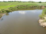
Dabas parks, kura lielāko daļu aizņem neprastās formas un līčiem bagātais Cārmaņa (arī Cārmins) ezers. Ezera ūdens ir ļoti tīrs, tādēļ tajā sastopamas Latvijai retas augu sabiedrības. Tā kā parka teritorijā nav tūristiem veidota infrastruktūra, interesenti var baudīt skatus, kas paveras uz ezera un tā apkārtni no Aulejas – Grāveru ceļa.
|
|
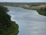 |
This lovely part of the Nemuna River between Alytus and Pakuonis meanders through cliffs that are up to 40 m high.
|
|
 |
Folkloras taka "Jāņkalni" iepazīstina ar mūsu senču rakstiem, zīmēm un dievībām, kas ir mūsu folkloras mantojums. Folkloras takas (garums: apm. 1,5 km vai 2 stundas) mērķis ir arī iepazīstināšana ar senlatviešu ieražām, folkloru, kā arī tautu dainu izprašana. Piedāvā iziet Latvijas karti - labirintu ar 19 etnogrāfiskajiem novadiem. Gids Jums sniegs izsmeļošu stāstījumu un atbildes uz interesējošiem jautājumiem.
|
|
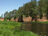 |
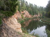
This park is in an area which has not been affected much by humankind – sandstone cliffs, an undisturbed diversity of caves, other habitats, species and landscapes is the attractive aspect of this area. The Salaca River is one of the most important rivers in the Baltic Sea region for the spawning of salmon, and it is the second most popular river for water tourists in the Latvian region of Vidzeme. There are geological monuments which are very attractive to visitors – the Red cliffs, Skaņais Hill, the Neļķu cliff, the Velna (Devil’s) cave, etc. There are also cultural monuments such as the Livonian castle hill, the Vecsalaca baronial estate, the Livonian Museum, the Vantenberģi estate, the unique Salaca lamprey weirs, etc. Also in the park is one of the most popular tourist destinations in Northern Vidzeme – the Skaņākalna park, which has a dense network of footpaths. The Salaca is also popular among fishermen. This is part of the Northern Vidzeme Biosphere Reserve. |
|
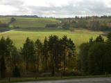 |
As you travel from Kandava to Sabile, you will find a parking lot on the right side of the road. From there, there are steps to a viewing area on the highest hill in the Abava Ancient River Valley – Greiļi Hill. This offers a wonderful view of the ancient river valley and the local mosaic of meadows and forests. The landscape is enriched by the Imula and Amula valleys that are on the other side of the ancient river valley.
|
|
 |
In the central part of the Žemaitija Highland, this park was established to protect local landscapes. Lithuania’s highest hillocks are found here – Mėdvegalis (235 m above sea level) and Šatrija (229 m). There are also other hillocks which offer a great view of the area – make up your own tour here.
|
|
 |
The Neļķes cliffs are in Skaņākalns Park, and they offer the most beautiful view of the Salaka River valley, with its sandstone cliffs and peaceful river. There are good views from the “devil’s pulpit.” It’s worth visiting the Skaņamkalns Hill to check out the views from the famous echo cliff. This is part of the ZBR.
|
|
 |
There are three large lakes at the centre of this park – Lake Dusia, Lake Metelys, and Lake Obelija. Lake Dusia has very clear and transparent water, and its southern and south-eastern beaches are popular among swimmers. The lakes and their nearby wetlands are important during the migration season of birds.
|
|
 |
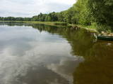
Богатое заливами и полуостровами озеро Цириш (находится в Циришском природном парке) украшено несколькими островами, наибольший из которых - Упурсале укрыл в листве своих деревьев городище древних латгалов – Упуркалнс. У подножья обнаружены свидетельства древних поселений и найдены черепки посуды, каменное долото и другие предметы. На берегу восточной части острова устроена лодочная пристань лодок, а вокруг острова проложена благоустроенная природная тропа. |
|


