
| Нo | Название | Описание |
|---|---|---|
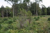 |
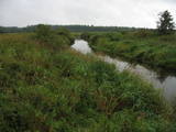
One of few places in Latvia (around 1 km to the North from Lapmezciems) where used to be beautiful juniper meadows. Since no agriculture activity (grass cutting, cattle grazing) has been implemented in the area, juniper meadows are overgrowing and disappearing. To save the area sustainable management is needed. Slitere National Park with Blue Mountain cliff and Slitere lighthouse is located in short distance from Kadiku nora (Juniper meadow).
|
|
 |
Lake Liepāja is shallow and eutrophic (around 40%), and it is one of the most important lakes on the shores of the Baltic Sea for nesting and migrating birds (resting and feeding place). More than 100 different species of birds have been spotted there. The lake is no less important for plants which flourish in salty biotopes. On the north-eastern shore of Lake Liepāja (Vītiņu meadow) there are flood-land plains which are the home to domestic animals which have been adapted to life in the wild. There is also a viewing tower, available upon request with the guide. The system of dams along the south-western part of the lake can be hiked or biked (extreme!) to find lots of interesting viewing areas and landscapes. In the surrounding of the lake there are ruins of unique former fortification systems. |
|
 |
A small and forested territory with sulphurous springs, among which the most popular one is the Ellīte sulphur spring. It has sulphurous water with a low level of minerals, and the water supposedly has medicinal properties. The area around the stream is well-appointed, and a pathway leads to it. The stream is considered to be the source of the Iecava River. The restricted area is there to protect biotopes and protected plants which are in the area.
|
|
 |
This is an area that is full of legend and tale. There is a stiff hillock, which stands about 66 metres above the surrounding land. From its southern side, you can see the Burtnieki lowlands. The tower, however, is not open to the public.
|
|
 |
The restricted area was set up to protect Nesaule Hill, which is a forested hillock in the area and features boreal and damp forests.
|
|
 |
One of the most distinct sub-glacial depressions in Latvia, with 11 lakes of various sizes and depths. This is a magnificently lovely territory, with particularly good views from the Drusku castle hill. On a clear day, one can even see the Hanja highlands of Estonia. The restricted territory was set up to protect boreal and hillside forests I the area.
|
|
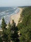 |
Construction on the lighthouse was initially completed in 1879. The structure suffered damage during both world wars and was restored several times. The structure is 19 metres high and stands 46.5 metres above the wavy sea. Here you will find one of the loveliest views of the shores of the Baltic Sea.
|
|
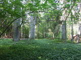 |
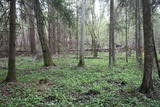
This is a fairly unique territory in Latvia – a vast forest of oak trees (many of them very large, indeed), linden trees, elms and various other deciduous trees. In the company of a forest guide, the visitor can walk through a small part of the forest, learning about the inhabitants of the area and their importance. This is an environmentally protected zone.
|
|
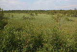 |
There is no need to enter the bog to see it, there are good views from the highway Ventspils – Riga (77 km, bus stop “Pagrieziens uz Elkskeni”). The main value of restricted area is chalky fen bog with brown bog-rush (greatest habitat finding in Latvia). Be careful when stopping on the highway – mind the traffic! A couple of kilometers towards Riga, on the right side of the highway, there is sign to Grizu Velna kresls ( Grizu Devil Chair) which is an attractive boulder (protected).
|
|
 |
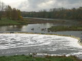
Above and below the town of Kuldīga, the Venta River is distinguished by a variety of biotopes – hillside forests, sandstone and dolomite cliffs, meadows, protected plants and animals, and diverse landscapes. There are popular tourism objects in this part of Kurzeme – the Venta dam, the stone bridge of Kuldīga, the Veckuldīga castle hill, etc. An ecological tourism trail runs along the banks of the Venta, and a bicycling trail has been installed on its left bank. |
|
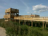 |
This is the only viewing platform in Latvia which is wheelchair-accessible. From the second level, you can see much of the restricted territory – areas of reeds, some wetlands, dunes and the estuary of the Daugava River. This is a good location for bird-watching.
|
|
 |
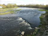
The recently renovated old brick bridge and the viewing area that is on the left bank of the Venta beyond the castle guard’s hut offers a lovely view of the widest and most impressive waterfall in Latvia – the Venta falls. It is worth visiting during the spring floods, when fish are migrating.
|
|
 |
One of the rare places (see also Rucavas ivju audze) in Latvia where two rare and protected wild tree species grow - yew-tree and Baltic ivy. Territory is not marked on site with information signs or stands therefore it is hard for visitors to find. Not usable as tourism object.
|
|
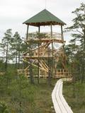 |
This is part of a hiking trail along the Cena bog. It is on the western side of the bog, at the centre of the 5-kilometre circular trail. You can see the vast swamp, as well as a military road that was installed during World War I and is marked by an “alley” of large pine trees. Alongside the tower is a fragment of the road that was installed more recently.
|
|
 |
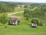
At the centre of this restricted area is the eutrophic Lake Tosmare, a former lagoon from the Littorina Sea. The lake and its surroundings offer protection to many plants and birds. At the southern end of the lake one can spot remnants of the former Liepāja fortification system, and to the West is one of the most important parts of that system – the Fortress canal. |
|
 |
The Kaļķupe River valley was established as the Pilsupe River (formed by Kaļķupe River and Mazupe River) crossed the Blue hills of Šlītere to the South of Vīdale and Kaļķi. The distinct river valley has a branched network of gullies in which Devonian sandstone has been uncovered and can be seen in some locations. Puiškalns Hill (located at confluence of Kaļķupe River and Mazupe River), which was used as a castle hill and as a sacred location long in the past, is one of the most distinctive parts of the area. It is a popular tourist destination in the Talsi District. Hillside forests, various kinds of meadows and a wide range of plants are also of value in the local environment. |
|
 |
Dabas liegums veidots ainaviskā Kāla ezera trīs salu (Tolkas, Lielā Vestienas un Vistu sala) un to mežu biotopu aizsardzībai. Diemžēl, salu apmeklētāji (makšķernieki?) aiz sevis ir atstājuši ne tikai nelabiekārtotas apmetņu un ugunskuru vietas, bet arī atkritumus. Tā kā salu vērtību spēs novērtēt tikai zinošs speciālists, ieteicams dabas liegumu vērot no skaistajiem un pauguriem klātajiem Kāla ezera ziemeļu un austrumu krastiem. Teritorija atrodas Vestienas aizsargājamo ainavu apvidū.
|
|
 |
Palieņu pļavas starp Rūjienu un Rūjas ieteku Burtnieku ezerā, kurām raksturīga liela augu un putnu sugu daudzveidība. Tās robežojas ar bijušiem Rūjas zivju dīķiem, kas šobrīd aizaug ar mežu. Rūjas palienes var vērot gan braucot ar laivu pa Rūju, gan arī no ceļa, kas ved uz minētajiem dīķiem. Tur izvietots informācijas stends.
|
|
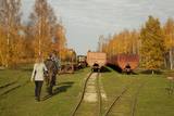 |
Sedas purva kājnieku maršruts atrodas dabas liegumā Sedas purvs, pārgājienu pa maršrutu iespējams apvienot ar Sedas pilsētas apskati, kas ir unikāls 20.gs. 50.–60. gadu pilsētbūvniecības un arhitektūras paraugs - kūdras purva strādnieku pilsēta. Maršrutam ir divi apļi - Jērcēnu aplis - 5,5 km un Sedas aplis - 4,2 km. Tajos apakatāms izstrādātais kūdras purvs, šaursliežu dzelzceļš, ritošais sastāvs, divi skatu toņi. Rudenī un pavasarī - putnu migrācijas lāikā - interesanta vieta putnu vērošanai. GPS koordinātes: Jērcēnu puses aplim: 57.7055987, 25.7001324; Sedas puses aplim: 57.6699587, 25.7514815. |
|
 |
Līčiem, pussalām un salām bagāts ezers ar izrobotu krasta līniju, kas savienots ar Zvejnieku un tālāk - citiem Latgales augstienes ezeriem. Ozolu un platlapju meži, kas aug uz ezera salām un pussalās ir ne tikai aizsargājami, bet arī Latvijas mērogā nozīmīgi biotopi. Tiesa, to vērtību apzināsies tikai vides speciālisti. No Jašas ezera var uzsākt laivu braucienu pa vienu no Latgales ezeru "kēdēm". Ezera austrumu krastā atrodas Geļenovas parks.
|
|


