
| No | Name | Description |
|---|---|---|
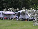 |
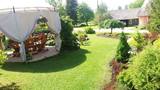
The "Jurmala" campsite is located in the park territory of the "Rīgas Līcis" sanatorium and offers facilitated tent, camper and caravan sites, as well as holiday homes for rent. The campsite is located next to the beach and is suitable for recreation with family and friends, as well as for organizing a variety of thematic and recreational events. The proximity to the "Dubulti" and "Jaundubulti" railway stations makes it easy to move around Jurmala or get to Riga. The campsite is also suitable for families with pets. |
|
 12 days
|
This tour offers seeing the capital cities and most attractive towns of Lithuania, Latvia and Estonia through the freedom of independent travel and using public train and bus services. Getting around in cities and towns is easy, either by walking, or by using local public transport or taxis. The Old Town of Vilnius is in the UNESCO World's Cultural Heritage list. Daugavpils Fortress and the museum of Mark Rothko, the world famous abstractionist, are two highlights of Daugavpils city, Rēzekne city is known as the heart of Latgale region. Riga, the capital city of Latvia, offers a variety of cultural experiences and entertainment. Sigulda is famous for its landscapes and medieval castles. Cēsis is one of the most charming towns in Latvia with many attractions ranging from medieval heritage to nice restaurants, exhibitions and festivals. Valmiera offers art galleries, museums, nature trails and Valmiermuža beer from the famous local brewery. Tartu in Estonia is a university town, with some very popular tourist attractions such as the interactive AHHAA science centre, the largest in Baltic countries. Narva is a border town overlooking the Ivangorod fortress in Russia across the river Narva. Finish the tour in Tallinn – the capital city of Estonia. Tourist information centres in cities and towns will help you with maps, information on sights, attractions and guided tours, food, shopping and public transport. |
|
 1 day
|
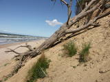
This section of the Baltic Coastal Hiking Route is a comparatively short hike across a beautiful sandy beach, the coastal side of which is bounded by brightly colored pine forests with spectacular dunes and dams of dunes. To get from the beach to Carnikava, the Baltic Coastal Hiking Route will take you through a forest via a promenade. Then it takes a stroll around the Old Gauja River via a levee and reaches the pedestrian bridge over the Gauja River. Both as you start and end the hike, it is nice to sit in one of the pubs and summer cafés located on Vecāķi beach and in Carnikava. |
|
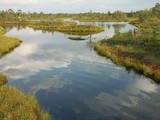 |
The Ķemeri National Park was established in 1997 and mostly involves wetlands – the shallow shores of the Bay of Rīga, an overgrown seaside lake, vast swamps, damp forests and fens, and flood-land meadows. The park is enormously important for protecting plants (25% of those recorded in Latvia’s Red Book are found in the park) and animals, particularly nesting and migrating birds. The Great Ķemeri Bog is one of the largest swamps in Latvia, and there are other swamps, as well – the Zaļais swamp and the Raganu swamp. The massive swamps are important, too, in the flow of sulphuric waters and medicinal mud. The once-famous Ķemeri Spa was based on the availability of these resources. Most of the cultural and historical objects in the Ķemeri National Park relate to the seashore as a place for leisure and recuperation. Educational nature trails, bicycle trails, hiking trails, bird-watching towers and other facilities are available. The visitors centre is at the recently renovated “Forest House” in Ķemeri. |
|
 |
The spacious cafe in Gulbene with comfortable chairs and a tasty meal of the day menu. It is also possible to taste various types of pizza and dishes typical for the Gulbene district. Working hours: Monday-Thursday: 10:00 - 22:00, Friday-Saturday10:00 - 03:00, Sunday 11:00 - 22:00 |
|
 |
The largest town in South-Eastern Latvia is on the banks of the Daugava River, which is the border between Latvia and Belarus at this location. The border runs down the middle of the river. Piedruja has two parts – Piedruja and Aleksandrova, which are separated by a central street (the V 631 road). Piedruja emerged from the Druja town that was on the left bank of the Daugava. During the 17th century, the two parts were owned by the Stapekha dynasty of Lithuanian aristocrats. It is worth strolling through the town, because the low-level wooden houses are reminiscent of buildings that are exhibited in open-air ethnographic museums. Piedruja is neat and tidy, with two churches and the Daugava rock that are part of a local hiking trails. Aleksandrova has a tourist accommodation, “Piedruja,” which offers special soirées in the Lettigalian, Russian and Belarusian style. Please be aware that you need a temporary permit to enter the border zone. The Border Guard facility is in Piedruja and at a place where there was a Daugava crossing point comparatively recently. |
|
|
|
Atrodas sporta un atpūtas kompleksā „Trīssaliņas”. No torņa paveras pievilcīga apkaimes ainava, kas īpaši skaista ir pieneņu ziedēšanas laikā. |
|
 |
Suitsu tornis celts 1979. g. kā pirmais Matsalu rezervāta metāla tornis. To atjaunoja 1998. g. Torņa augstums ir 21 m, tādēļ no tā paveras izcila dabas un kultūrainava uz Kazari deltas niedrājiem un blakus esošo Suitsu upi (Suitsu jõgi), kuras krastā ir uzceltas vairākas zvejnieku laivu būdas. |
|
 |
This exhibition has been assembled over the course of many years by its owner, Valdis Tumovs. He features war weapons, fragments of munitions, uniforms, everyday objects, military equipment such as a motorcycle, etc.
|
|
 |
Ancient legends say that ship sank in the sea near the old cemetery during a storm and during a worship service. The pastor and members of the congregation volunteered to use a rowboat to save the crew of the ship. Some of the men were rescued, while others were washed ashore. In honour of this tragic, but also happy solution, the captain called the place Feliksberga, or the Lucky Shore. Later it became known as Pilsberga, and it was renamed Jūrkalne only in 1925. |
|
 |
The ancient Abava River Valley between Kandava and the place where the river flows into the Venta River is the most expressive river valley segment in Kurzeme in terms of landscape and terrain. The valley is 30 to 40 metres deep and as much as 300 metres wide. The territory is distinguished by great diversity of a biological nature (more than 800 kinds of plants), featuring many different biotopes and natural monuments such as streams, waterfalls, cliffs, huge rocks, and many cultural and historical monumentssmall towns such as Kandava and Sabile. In both cases, the town centres are national monuments of urban construction. Popular tourist destinations include Vīnakalns hill in Sabile, where wine-making grapes are grown, as well as the open-air art museum at Pedvāle. To protect cultural treasures, a cultural and historical territory, “Abava River Valley” has been established. Wild livestock live at Drubazas and Tēvkalni to “maintain” the landscape. There are nature trails for tourists, and the Abava is the most popular river for water tourists in Kurzeme. Information is available at the tourist information centres in Kandava and Sabile. such as castle hills, churches, ancient burial grounds, and
|
|
 |
The aim of this territory is to regulate the natural and cultural landscapes of the upper reaches of the Daugava River valley, where there is a great deal of biological diversity. Nature trails have been installed in the park, as have bicycle routes. The river is good for boating in this area, too. The Curves of the Daugava nature park is part of the territory (see “Nature Parks”). |
|
|
|
Atrodas Liepājā, E. Tisē un Lauku ielas krustojuma galā. Pa Ezera laipu (Liepājas ezera palieņu pļavas) var nokļūt līdz putnu vērošanas tornim, no kura labi pārlūkojama ezera ziemeļdaļa. Laba putnu vērošanas vieta. Ietilpst Liepājas ezera dabas lieguma teritorijā. |
|
 |
“Saules veltes” ir mājas vīna darītava Salaspilī, kas nodarbojas ar mājas vīnu, liķieru un degvīnu gatavošanu. Alkoholiskie dzērieni tiek ražoti no dabīgiem dārza augļiem un ogām, tostarp upenēm, avenēm, cidonijām, pīlādžiem un pat mārrutkiem. Apmeklētājiem ir iespēja aplūkot saimniecību (uzņem arī 15-20 lielas tūristu grupas), kā arī degustēt konkrētos dzērienus, kurus arī turpat ir iespējams iegādāties; piedāvājumā lieli un mazi tilpumi, dāvanu un suvenīru komplekti.
|
|
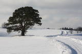 |
This is an unusually shaped pine which, according to legend, was planted by the king of Sweden during the Great Northern War.
|
|
 |
Atrodas Baznīcas ielā 10. Skaistā ēka ir viena no nedaudzajām 17. gs. celtnēm, kas būvēta koka pildrežģa tehnikā (restaurēta 1986. g.). Kurzemes hercogistes laikā tajā atradās pirmā zāļu tirgotava. Apskatāma no ārpuses. |
|
 |
This farm is in a lovely location that offers a view of Lake Sauka. He breeds cattle which spend all year long on the sides of nearby hillocks. The owner will offer you a tour, show you the animals, and offer sweet cherries and apples from his garden. |
|
 |
This farm welcomes groups and individual travellers for a smoke sauna, lunch, and a chance to taste Suiti bread, buns and special seed pastries that are based on ancient recipes. |
|
 |
It is worth hiking this road where in crosses the Šlītere Blue Hills. This part of the road is approximately one kilometre long, and it goes down to the valley of the stream which crosses the hills. The place has been given a peculiar name – the Kušperlankgrāvis ravine (or the Zeltiņi ravine, as is claimed in other sources). If you're driving, be careful, because there is no bridge here, just a ford. During the early spring or the winter, you will appreciate the ravines and the impressive Blue Hills themselves. Impressive sandstone cliffs which are several metres high and have been vandalised by human hands are on both sides of the road. There is a small niche in one of the cliffs. To the right (East) from the road at the terrace of the Blue Hills is a side road which leads to the Mežlīdumi homestead. Please be gentle with the cliffs! |
|
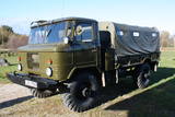 |
Edgars Kārklevalks, operator of a guesthouse Pūpoli, has a restored Soviet military GAZ-66 truck in which he offers historical and informational tours of Northern Kurzeme. The route includes former military territories.
|
|


