
| Нo | Название | Описание |
|---|---|---|
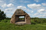 |
На берегах долины реки Абава в окрестностях бывших усадеб Фиркспедвале и Бринькпедвале по инициативе скульптора Ояра Арвида Фелдберга в 1992 году был создан музей-парк под открытым небом. Здесь можно посетить выставки современного искусства, а также поучаствовать в художественных симпозиумах и творческих мастерских, а также в других мероприятиях. |
|
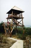 |
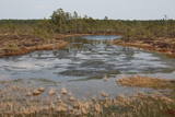
Salīdzinoši liela un cilvēka mazskarta teritorija ziemeļos no Lubāna ezera, kas izceļas ar lielu purvu un mitro mežu, kā arī tajā dzīvojošo organismu daudzveidību. Cauri teritorijas austrumu daļai tek Aiviekste. Dabas liegums ir grūti pieejams, tajā nav izveidota ar tūrismu saistīta infrastruktūra, tādēl vislabākais veids ir to aplūkot no Lubānas - Gaigalavas ceļa, kā arī putnu vērošanas torņa pie Gomeļa ezera (Gūmelis), kurš gan 2007. g. rudenī bija cietis no apmeklētāju vandālisma. Teritorija ietilpst Lubāna mitrāja kompleksā.
|
|
 |
Молочное предприятие производит сыры по старинным латвийским рецептам. Как сто и более лет назад, сыры делают вручную. Продукции присвоен знак качества «Зеленая ложечка». Свежий сыр можно коптить. Организует экскурсии, во время которых можно ознакомиться с предприятием. Принимает заказы и доставляет готовую продукцию. |
|
 12 дней
|
The tour combines the most beautiful southern parts of the Forest Trail in Lithuania and Latvia. The route starts in Druskininkai, Lithuania, and for the next day you will walk through forests of the Dzūkija National Park. After getting to Vilnius and Kurtuvėnai Regional Park, two sections of the Forest Trail will take you from Dengtiltis to Šaukėnai. Since it is among the most forested areas of Central Lithuania, the Kurtuvėnai Regional Park with its glaciated valleys is a wonderland of forests, waters and wetlands. The Forest Trail will run along small forest paths, tourist trails, beautiful tree alleys and wetlands. Next you will take public transportation to reach the Žemaitija National Park, where you will taketwo sections of the Forest Trail from the pilgrimage town of Žemaičių Kalvarija along the lakes of Plateliai, Ilgis and Beržoras to the town of Plateliai. It is one of the most beautiful towns of Samogitia taking pride in its manor park and the viewing platform on Lake Plateliai. Žemaitija National Park takes pride in its old pine and fir forests, as well as mixed forests. From there on the Forest Trail takes you along the riverside promenade in Kuldīga, continues through the nature park “Abavas senleja” from Renda to the wine and cider town Sabile and Kandava. The section along the Abava River Valley Nature Park is the most diverse river valley in Kurzeme in terms of landscapes and terrain. The final section of the tour takes you to the Ķemeri National Park, which is an important place for the protection of wetlands. As to the town – Ķemeri – it is the former balneological and sulphur springs resort. The tour ends on the seaside – the village of Bigauņciems, from where you can easily get to Rīga. Optionally, one can take a detour along the Lake Sloka trail with its bird-watching tower or pay a visit to the “Forest House” – the visitor’s centre of the Ķemeri National Park. |
|
 7 дней
|
Выезжая из Риги, сделайте остановку в Национальном парке Кемери, для того, чтобы пройтись по дощатому настилу через таинственное болото. На дальнейшем пути – остановка для сладкоежек – Музей Шоколада Пуре. Вентспилс – один из самых богатых городов, с отличной инфраструктурой, хорошо отреставрированным замком Ливонского Ордена, променадом, изысканными фонтанами и ухоженными парками. Весь город ориентирован на семейные ценности, но детям особенно по душе пляж Голубого флага, с его различными качелями и горками, а также Детским городком, поделенным на разные возрастные зоны. Особое развлечение для детей и взрослых - короткая поездка по узкоколейной железной дороге. Насладиться водными забавами можно в открытом или закрытом аквапарках. Отправляйтесь сами на машине на экскурсии по окрестностям, по живописному морскому побережью, традиционным рыбацким деревням, где у рыбаков можно купить копченую рыбу, в Национальный парк Слитере с его красивым открывающимся с маяка видом, очаровательную Кулдигу с ее деревянным зодчеством и водопадом. На обратном пути в Ригу, взрослым понравится остановка в домашней винодельне, чтобы отведать замечательные вина, изготовленные из чего угодно, только не винограда. Детям, в свою очередь, предлагаем побывать на ферме, познакомиться с сельскими животными и покормить кроликов. Перед Ригой, остановитесь в Юрмале, знаменитом историческом морском и спа курорте. |
|
 |
This is the first national park in Estonia and the Baltic States. Perfect for a day trip out from Tallinn for a hiking trip and nature watching. It was established in 1971 to protect the area that is along the Bay of Finland – the shoreline, forests, swamps, meadow biotopes, species, natural monuments, rocks, waterfalls, cliffs and cultural monuments such as ancient cemeteries, castle hills, baronial estates, fishing villages, etc. |
|
 |
Трактир Kaali на протяжении долгих лет предлагает своим гостям лучшие блюда и напитки эстонской и сааремской кухни, приготовленные из местных продуктов, а также знакомит с культурой и историей острова. Посетители музея и метеоритного кратера Каали могут здесь вкусно перекусить. |
|
 |
Небольшой городок по дороге из Риги в Бауску. Название города впервые упоминается в письменных источниках в 1492 г. Объекты для осмотра: лютеранская церковь и парк бывшей господской усадьбы. |
|
 |
Old Kybyn Inn in Trakai serves traditional Lithuanian food like their Karaite meat pasty – the Kybyn as well as other sorts of food. |
|
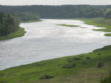 |
The Dinaburga trail first goes downhill, and then it quickly goes uphill to the steep shores of the Daugava river. Among a set of gullies, there is the Naujene (Vecpils) castle hill – some 25m high and the “cradle” of the city of Daugavpils. The ruins of the castle are still visible, and a unique open-air model of the old Dinaburga castle has been prepared. There is a lovely view of the Daugava river valley, and the visitor can expect to spend 20 minutes to an hour here. Objects are located in a protected area of Augšzeme landscapes and in the Curves of Daugava nature park.
|
|
 |
Уютное кафе в центре Лиепаи. Кофе, вкусные пирожные, отличная еда. Каждый день – около пяти часов утра – за работу принимается мастер по приготовлению круассанов, чтобы уже в девять предложить посетителям свежую утреннюю выпечку. |
|
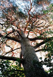 |
This is Latvia’s thickest common pine (Pinus slyvestris)
|
|
|
|
Vom 18. Jh wurde die Stadt ein russischer Marinestützpunkt. Von 1962 bis 1994 war Paldiski ein Übungszentrum für atomare U-Boote der Sowjetischen Marine mit zwei auf dem Festland befindlichen Kernreaktoren (ung. 16.000 Beschäftigte) und eine "geschlossene Stadt". |
|
 |
Ложметейкалнс в Тирельпурве является историческим памятником государственного значения – единственный культурно-исторический заказник в Латвии (парк памяти Рождественских боев). Стоит подняться на восстановленную смотровую башню, откуда открывается вид на Мазтирельское болото с бывшей старой узкоколейкой, пересекающей болото в северо-южном направлении (в природе обозначенную как самый большой деревянный ряд в болоте). В окрестностях домов Ложметейкалнса, Тирельпурва и Мангали сохранились уникальные свидетельства Балтийского масштаба о фортификационных сооружениях Первой мировой войны и проходивших в этих местах Рождественских боях. В Мангали можно осмотреть посвященную боям экспозицию, так называемые немецкие валы и др. С территорией знакомят опытные гиды. Кроме того, в парке проходят тематические и познавательные мероприятия.
|
|
 |
This trail of pathways dates back to 2005 and it passes from the Dunte Estate (which has an exhibition about Munchhausen) along damp shoreline forests and on to the sea. There are rest stops along the trail with wooden sculptures related to the famous Baron Munchhausen, as well as other attractions. The trails are in the Northern Vidzeme Biosphere Reserve.
|
|
 |
Находится в историческом центре Лигатне (около пруда), в здании, где делалась первая лигатненская бумага. Латышская кухня: Строганов по-Видземски, приготовленная на гриле колкская салака, приготовленная на гриле свинина, аматская форель, картофельные блины с деревенской сметаной, домашние блины с варением, пиво и квас. Особое блюдо: Десерт «Лустузис». |
|
|
|
Vecauces ev. lut. baznīca ir valsts nozīmes arhitektūras piemineklis. Baznīca pirmo reizi uzcelta kā koka būve 1667. gadā, bet pēc zibens spēriena 1729. gadā tā nodega. Mūra baznīca celta 1744. gadā, savukārt 1866.gadā Mēdemu valdīšanas laikā baznīcu paplašināja līdz 500 sēdvietām, izgatavoja jaunu altāri, kanceli un uzstādīja Liepājas ērģeļmeistara Kārļa Hermaņa būvētas ērģeles. meklētājiem piedāvā doties interesantā, izklaidējošā un informatīvā ekskursijā pa baznīcu, apskatot ekspozīciju "Auce pirmās Latvijas brīvvalsts laikā" un baznīcas bibliotēku (Baznīcas grāmatas (pirmās Latvijas brīvvalsts laiks – 1918.-40.g., vācu laiks, padomju laiks un šodiena)). Baznīcā izveidotajā Mākslas telpā apskatei tiek piedāvātas vairākas unikālas ekspozīcijas: skolotājas Jadvigas Kupčes grāmatu un personīgo lietu ekspozīcija, kantātes “Dievs Tava zeme deg” vārdu autora Andreja Eglīša ekspozīcija, izcilā flamenko ģitārista Andreja Kārkliņa un režisora Kārļa Pamšes ekspozīcijas. |
|
 |
Iepazīstina ar Somā nacionālā parka lielākā purva – Kureso (Kuresoo) ziemeļaustrumu daļu, kur redzamas purva ezeriņu un lāmu ainavas. Takas sākumā atrodas igauņu komponista, ērģelnieka un folkloras vācēja Marta Sāra (Mart Saar) (1882. – 1963.) dzimtās mājas. To apkaimē pļavas apsaimnieko aitas. Lokveida takas garums ir 4,2 km. |
|
 |
Корчма Мульги находится в столице Мульгимаа в Абья-Палуоя, где вам предложат уютную обстановку, блюда мульги и приятное обслуживание. Корчма располагается в восстановленном 100-летнем доме. |
|
 4 дня
|
В мемориальном саду Эдварда Вирзы вы можете увидеть деревья, которым посвящены стихи. Э. Вирза был латышским поэтом и писателем, написавшим легендарный роман "Страумени" о жизни латвийских крестьян. Красивый замок 18-го века Мазмежотне был восстановлен семьей зернопроизводителей. Рундальский замок известен как жемчужина Латышского барокко и рококо, которая включает в себя парк французского стиля и розарий с более чем 2200 сортов роз. В усадьбе Брукна вы сможете осмотреть сад, который был построен как парк эпохи Возрождения, розарий и виноградник. В винограднике «Рудзитес» произрастают около 80 сортов винограда, в свою очередь в черносмородиновом саду хозяйства «Баниши» можно набрать вкусных ягод. Хозяйство «Гундегас» имеет красивый ландшафтный сад. В Варкавском парке находятся 200-летние дубы. «Риекстини» - это аутентичное хозяйство одной семьи региона Селии с особым духом и атмосферой. В Калдабруне вы посетите музей и художественную галерею сена, который расположен в сарае. Выращивание и селекция винограда было большой страстью Паула Сукатниека, и его мемориальный сад стоит посетить во время уборки урожая. Усадьба Двиете гордится своим ландшафтным парком 19-го века и каменным мостом. Даугавпилс - второй по величине город Латвии, известен восстановленной Даугавпилсской крепостью 19-го века и музеем Марка Ротко. Питомник по выращиванию деревьев Селии предлагает экскурсию по яблоневому саду, хранилищу для яблок и производственным помещениям. Насладитесь стаканом яблочного сока и историями производителей вина. В Беркенеле находится мемориальный дом Райниса – знаменитого латышского автора и общественного деятеля. Рокишкский краеведческий музей и усадьба являются одним из важнейших культурных центров Аукштайтского края. В саду сельского музея Людвики и Станиславы Диджилю собраны традиционные литовские сорта яблонь, цветов и растений. Мемориальный музей А. Баранаускаса и А. Виенолиса-Жукаускаса знакомит с культурой, литературой, историей, аграрной культурой и технической историей Аникщяйского региона. Традиционный литовский цветочный сад можно увидеть в Мемориальном музее Броне Буйвидайте. В Аникщяе можно прогуляться по тропе среди верхушек деревьев и по парку лабиринтов, а также отправиться в поездку по Аукштайтской узкоколейкой железной дороге. В Ботаническом саду Траупья вы найдете все, начиная с коллекции многолетних цветов и каменных садов, до часов из цветов и декоративных бассейнов с водными растениями. Интерьер поместья Тауенов украшен портретами семьи Радзивиллов, скульптурами, охотничьими трофеями и антикварным оружием. Прогуляйтесь по старому городу Укмерге и полюбуйтесь видом со старой пожарной башни. Хозяйство «Сурвилай» предлагает тропу для прогулок босиком, где можно пройтись по болотистой поверхности, поверхностям из сосны, торфа, глины, гравия, полированного стекла, сосновой хвои, соломы и по другим видам поверхностей. В Укмергском районе посетите Узугирскую усадьбу президента Антанаса Сметонаса, где в его честь оборудован мемориальный музей. В конце путешествия осмотрите Литовский музей под открытым небом, один из крупнейших (194 га) и богатейших (91 420 экспонатов) этнографических музеев под открытым небом в Европе. В Каунасском ботаническом саду университета Витаутаса Великого растут уникальные растения, обустроена самая большая оранжерея в Литве, старинные литовские клумбовые растения представлены по разным растительных группам в соответствии с ботанической классификацией. В хозяйстве Тадаса Иванаускаса у парка Обелинес вы сможете увидеть коллекцию из 300 сортов и видов растений, включая старейшее дерево - гинкго двулопастный. В Каунасе вы сможете увидеть самую старую - почти 360-летнюю - яблоню, высотой 8 метров, 285 см в обхвате на высоте 1,3 метра. Маршрут заканчивается в Каунасе, втором по величине городе Литвы, который был столицей 1920-1939 годов. |
|


