
| Нo | Название | Описание |
|---|---|---|
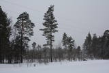 |
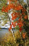
Between Saunags and Vaide on the road to Kolka, you will see an area on the left (South) side of the road where there was a massive forest fire in 1992 which burned approximately 3,300 hectares of forest. Biologists use the area to study the regeneration of the forest. There were extensive and destructive fires here during the early 20th century, as well. Swedish scientists say that there have been at least 15 fires in the forests of Šlītere over the last several centuries. The burned area is in a nature reserve and can only be viewed from the road. |
|
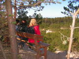 |
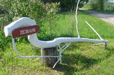
One of the highest dunes in Latvia, located between Bernāti and Jūrmalciems villages. It is 37m high and offers a magnificent view of the sea and natural pine forests. The highest dunes in Latvia stand to the South of Jūrmalciems village: the Pūsēnu hill, the Ķupu hill, the Mietragkalns or Tiesas hill, the Pāļu hill, the Garais hill, the Ātrais hill, the Lāvas hill. The Pūsēnu dune is the highest of these dunes which are all called hills by the local people. The Pūsēnu hill developed between 1785 to 1835 when shifting sand became extremely dangerous. Several homesteads were buried in sand, among them „Pūsēni”, where a forester’s family lived. The family is said to have moved to Bārta. The dune was named after the buried homestead. Jēkabs Janševskis, a Latvian writer, wrote in his book „Nīca”: “In olden times, large pine trees were growing in the dunes on the coast of Nīca and they stood steady and firm. But i Swedish times (around 1650), the Swedes built a large kiln for charcoal and tar. Pine wood and stumps provided an excellent material for this. Once a big fire rose, and the charcoal kiln burned down as well as the whole pine forest. The remaining stumps and bare trunks in the vast burnout could not hold the storm-driven sand; it flew further and further burying not only the burned-out forest, but also the nearest fields. In wintertime, when the vast, low marshy grasslands were covered with ice, jets of sand drifted further over its surface, and soon most of the grasslands and large meadows turned into sandy heath-land and dunes.” To reconstruct Liepāja, severely damaged during WWII, a silicate brick factory was built in the town. The main raw material was white sand and it was taken from the Bernātu forest. In the 1960-ies they started to dig off the Green Dune and the White Dune, later also the Pūsēnu hill. The excavators used to work day and night, in three shifts. The work stopped at around 1980, as there was no more sand suitable for production of brick. A trail is set up to facilitate walking in the Pūsēnu Dune in the Bernātu Nature Park. |
|
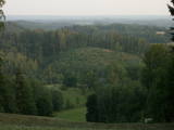 |
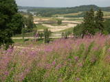
From the highest point in the Alūksne highlands, you will see an unusually beautiful view of the surrounding forested hillocks and the small areas of meadows and farmland. Sadly, there are no improvements to the location, which can be difficult to access. It is on private property.
|
|
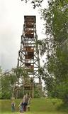 |
Lielais Liepu kalns ir Latgales augstienes Rāznavas pauguraines augstākā un Latvijā trešā augstākā virsotne (289,3 m v.j.l.). Lielpaugura relatīvais augstums ir 86 m! Skatu torņa platforma ir šobrīd augstākais Latvijas punkts (323 m.v.j.l.), kas sasniedzams ar paša kājām! Liepu kalna apkārtne ir labiekārtota. |
|
 |
Находится в центре Дикли. В построенном в 1896 г. замке, обновленном в 2003 г., обустроена 4-звездная superior гостиница. В замке Диклю можно осмотреть старинную мебель, камин и предметы роскоши, а также выставку картин художников Латвии. В двух ресторанах (летний, зимний) предлагают утонченное меню и индивидуальный подход. Сотрудничают с крестьянскими хозяйствами. Латышская кухня: Говяжий стейк, приготовленная на гриле форель, копченое сало кабана, филе судака из озера Буртниеку. Сезонно предлагаются собранные в местных лесах грибы и ягоды. Особое блюдо: Карбонад из оленины в сиропе из цукатов и луковом мармеладе. |
|
 |
На востоке от дороги Эзермуйжи - Думеле находится древнее русло (балка) Диевиньэзера. Это было одно из самых больших озер в Курземе - длиной 7,5 км и шириной 1,6 км. В 1838 году был вырыт канал - теперяшняя Мелнсилупе - и озерную воду спустили в море, чтобы получить плодородную почву для сельского хозяйства. Жители Эзермуйжи еще со времен баронов были связаны с лесным хозяйством и лесозаготовками. Думеле с Кошрагсом связывает одинокая лесная дорога - т.н. Нижняя дорога - по которой проходит велосипедный маршрут. В Думеле расположен коттедж для отдыха «Зиедкални». |
|
 13 дней
|
This tour can be done with your own or rented car and it includes driving, some hiking parts and transfers with the public transport. This grand Forest Trail and Baltic Coastal Hiking Route tour includes some of the best and most beautiful parts of the Forest Trail and Baltic Coastal Hiking Route in Lithuania and the southern part of Latvia. Hikes are combined with trips and excursions in cities, as well as other popular tourist sights in both countries. You will get a detailed impression about the forest diversity, coastal landscape and most popular national and regional nature parks in Latvia and Lithuania.
At the end of the tour you will go for a 1 day hike in Kurtuvėnai Regional Park which is one of the most forested areas in Central Lithuania with very pronounced glacier-shaped terrain forms spread in the Eastern Žemaitija Upland. |
|
 |
Latvia’s highest hill is the second highest in the Baltic States, but alas, it has only a wrecked viewing tower, so you’ll have to look for the best views on your own. You’ll find some around the tower and the ski trails, particularly Large and Small Golgotha. It is worth hiking the Gaiziņkalns nature trail.
|
|
 |
Хозяйство предлагает посмотреть лошадей, пони, кроликов, кур породы Брама и цыплят. Детям предлагается покататься на маленьком пони Xavier, как верхом (вес ребенка до 35 кг), так и в маленькой коляске. |
|
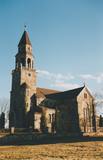 |
Величественная и монументальная церковь в стиле Тюдоровской неоготики (проект лиепайского архитектора Стандманиса) построена из колотых камней в 1908 – 1925 годах на месте прежней церкви, построенной из дубовых бревен в 1621-м году. С церковной башни открывается панорамный вид на окрестные озера. |
|
 |
В крестьянском хозяйстве «Витолини» разводят лошадей, а также обучают верховой езде. Можно покататься по лесу в упряжке или верхом. |
|
 |
Находится в южной части Лиепаи. Для ресторана характерна кухня открытого типа, где клиенты могут наблюдать за работой поваров. Латышская кухня: Суп из боровиков, рыбный суп, тонкие блинчики и картофельные блины, отбивная из баранины, приготовленное на гриле свиное филе, язык теленка, приготовленный на пару, баранья ножка, творожная слойка. Особое блюдо: Суп из трески от «Оливе» или особое сладкое пирожное. |
|
 |
This area protects the landscape of the Lielauce hillocks, which are a part of the Eastern Kurzeme highlands. Lake Zebrus and Lake Svēte are in this territory. On the north-eastern shore of Lake Zebrus one can see the Ezerlūķi castle hill. On the eastern shore of the lake is a boating area, along with a viewing tower and a set of information about the area. The territory includes protected biotopes such as stream swamps and swampy forests, along with protected birds and species of bat. |
|
 |
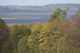
С познавательной точки зрения - это этнографическая деревня с сельской планировкой и характерными для Латгальского края домами с наличниками на окнах и ажурными фасадами. В Силтушки в «Доме старообрядцев» находится музей, где можно узнать о культурной среде и традициях старообрядцев. С древней долины Даугавы приоткрывается один из необыкновеннейших пейзажей Латвии. |
|
 |
Biedrība "Latvijas Slieku audzētāju asociācija" tika nodibināta 2010. gada 1.septembrī ar mērķi attīstīt sliekkopību un vermikomposta ražošanu Latvijā. Pamatnodarbošanās - vermikomposta ražošana. |
|
 |
Nature restricted area includes eastern side of the lake with Lanupe River and North-east and South-east coastal areas. Restricted area has been established for protection of birds and floodplain meadows of the lake. To see the nature restricted area visitors do not have to enter it. There are great view points with wind generators of Grobina on the background from the road Vecpils – Rava – Aistere. Coastal areas which are not included in the restricted area are perfectly suitable for bird watching. There is located the smallest city by its population in Latvia to the South from the lake.
|
|
 1 день
|
The Forest Trail leads through smaller paths, arching around Vangaži Lutheran Church and the Werewolf Pine. On its way to the Hunting Palace, it passes the garden created by opera singer Anna Ludiņa and then follows the Hunting trail. The first side ravines with the pronounced relief of the ancient valley of the River Gauja can be seen here. One of them is located by Inčukalns Velnala (Devil’s Cave), surrounded by small river channels of the old Gauja. From there, the Forest Trail continues through meadows and crosses the Murjāņi–Valmiera motorway, where the recreation park “Rāmkalni” is located. In this park, there is a café, shop and active leisure centre with a sledge track. On this route you will mainly see pine forests of various ages, as well as the botanical plantation with 80 tree and 120 shrub species. By the end of the section, the landscape features sandstone outcrops – Devonian sedimentary rocks and habitats protected in Latvia. |
|
|
|
Даже современным знатокам трудно предугадать, где в Рагасциемсе находилась бывшая зенитно-ракетная база, целью которой была защита западной границы СССР.
|
|
 |
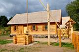
Хозяйка встретит вас небольшим рассказом о выращенном в хозяйстве здоровом травяном чае и испеченными ею лакомствами. Если есть желание провести ночь под открытым небом, мы предлагаем места для палаток и костров, расположенные на берегу реки возле старой мельницы Луку. Крестьянское хозяйство «Аплоки» ждет каждого, кто хочет отдохнуть в тихой и спокойной атмосфере. |
|
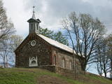 |
На западном берегу озера Цирма возвышается построенная из валунов в 1830 г. церковь. Известность ей принесла картина с изображением Девы Марии, которой приписываются чудотворные способности. Поэтому это - популярная конечная цель паломников. |
|


