
| No | Name | Description |
|---|---|---|
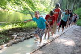 |
The first barefoot trail created in the Baltic States in the recreation complex "Valguma pasaule", which is located on the forested shores of Lake Valguma. When walking on the path, the feet "massage" sand, wood chips, clay, peat, gravel, cones and various other materials. |
|
 |
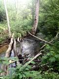
Vēršupīte is a small river which curves through the
town of Ķemeri and has more than 10 small and
romantic bridges across it – each with its own name.
|
|
 |
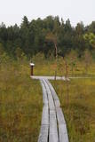
The Zaļais (Green) swamp is a medium swamp in
terms of the national park, and it used to be a place
where peat moss was extracted (those areas are flooded
now). In the North it links to the Čaukciems swamp. The
swamp is to the Southwest and West of the Green
Dune.
|
|
 |
One of the richest sources of sulphurous water in Latvia.
|
|
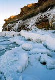 |
At the end of the Pakri peninsula is the most visually impressive shoreline cliff in the Baltic States – the Pakri cliff (Pakri pank), which is as much as 24 metres high. During cold winters, streams which flow from the layers of limestone cliffs form fantastic and unusual shapes of ice.
|
|
 |
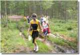
1.2 km long, the trail passes through a unique terrain of hillocks and forests, with the height of the valley rising to as much as 15 metres. Visitors will find a diversity of plant life, as well as the beautiful little Kauliņupīte River, which crosses the rail at two points. The health trail was established in the late 1990s. |
|
 |
The small Andrupene swamp is found to the North of the Andrupene Farm Museum in a deep area between hillocks. It is a high-type swamp with an open central part, and it is 130 m long and 120 m wide. There are stands of white alder alongside the swamp. In 2009, the administrators of the Rāzna National Park restored a wooden educational pathway that had been established originally by the Andrupene Elementary School. Today there are stairs, a viewing platform, wooden pathways, and information stands. |
|
 |
This is the highest point in the Latgale highlands (289 metres above sea level), opening up a narrow but lovely view of Lake Rāzna and the massive forests of the highlands. You really should visit this hill when the sun is setting beautifully!
|
|
 |
This is a segment of the Gauja River which is full of rapids in some places. It stretches from Vidaga and the place where the Vecpalsa River flows into the Gauja. Along the Gauja and its tributaries, dolomite outcrops can be seen on the shores, and the largest of these are the Randati cliffs. The restricted area was established mostly to protect various kinds of forests, meadows, outcrops and their habitats. This is an interesting part of the central section of the Gauja for people who enjoy beautiful landscapes and for those who are water tourists.
|
|
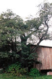 |
This is the thickest Black Alder (Alnus glutinosa) in Latvia
|
|
 |
The River Ķīšupe (length – 31 km) begins its journey in the marshlands of Lēdurga Parish. As the river reaches the seashore, its bed and the location of its mouth often changes. One of the tributaries of the Ķīšupe carries a rather interesting name – Pupaļurga. The name of the River Ķīšupe probably comes from the name of a man and his house. In the 17th century a man named Ķīsis (in English: ruffe) used to live by the river. |
|
 |
The viewing tower was built quite recently. At its foot is a location for relaxation. It offers a good view of one of the curves of the Daugava River – the Adamova curve. A bit beyond is the Curves of Daugava Nature Park. Along the tower is the “Saulkrasti Trail” bicycle route.
|
|
 |
Lielbātas dabīgais dzidravots ir lielākais Latvijā un viens no retajiem Ziemeļeiropā, kas zemes virspusē no dzīlēm iznes bioloģiski aktīvu un pareizi strukturētu ūdeni. Lielbātas dzidravots tek no rietumiem uz austrumiem pretī saulei, tāpēc jau izsenis tiek uzskatīts par maģisku, pat svētu, kam piemīt dziednieciskas spējas. Vēstures materiālos Lielbātas avots pirmo reizi pieminēts 1253. gadā un līdz šim brīdim turpina savu plūdumu. Lielbātas avots atrodas sakoptā un ekoloģiski tīrā vidē. Laikam ritot, avota ūdens plūsma nav mazinājusies, bet tieši pretēji, tā ir pieņēmusies spēkā un ar apbrīnojamu jaudu avots turpina dot unikālu dabas velti – tīru, bioloģiski aktīvu, pareizi strukturētu ūdeni, neapstājoties ne dienu, ne nakti, ne ziemu, ne vasaru. Netālu no avota atrodas vēsturiskā Vaiņodes jeb Lielbātas pils, kuru 19. gs. vidū būvēja barons Osten Sakens. Vēstures liecības liecina, ka šī vieta pils būvniecībai nav izvēlēta nejauši. 1923. gadā pilī tika izveidota sanatorija, kas ne tikai bija priekšzīmīgākā Latvijā, bet varēja cienīgi līdzināties ārzemju sanatorijām. Tam par iemeslu bija dabiski tīrā un dziednieciskā vide, kas saglabājusies līdz pat mūsdienām. Lielbātas pils ir privātīpašums un apmeklētājiem nav pieejama, taču Lielbātas avots ir brīvi pieejams, un katram ir iespējams nogaršot avota ūdeni. Adrese: Vaiņodes pils, Vaiņodes pagasts, Dienvidkurzemes novads LV-3535 |
|
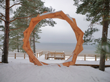 |
A new section of the walking trail along the sea has been built and an environmental object "Sunset watcher" has been created in Saulkrasti near the White Dune and Sunset Trail. It is a photo object where the newlyweds and every guest of Saulkrasti can capture memories in the symbol of the sun, which is so characteristic of Saulkrasti. |
|
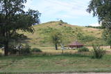 |
Ap 0,5 km ziemeļaustrumos no Stukmaņu muižas – Daugavas ielejas labajā krastā atrodas Vīna kalns – sens pilskalns. Tajā atrodas izpostītie Stukmaņu muižas īpašnieku kapi. Mazliet tālāk redzams klajš upes ielejas nogāzes posms, kurā savulaik darbojās slēpošanas trase. |
|
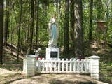 |
The castle hill of Milka is situated near Lake Sālaja and River Malta; 27m above the lake level. Local
businessman cleaned the hill and placed the statue of Mother of God there. It is a a symbol of Latgalian
strong faith into God and Virgin Mary.
|
|
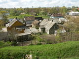 |
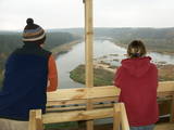
The Ludza castle hill offers one of the most interesting views in Latgale – that of the oldest town in Latvia and its historical centre, Great Lake Ludza and Small Lake Ludza, the ruins of the castle of the Livonian Order, Baznīckalns hill, churches, the regional research museum, the craftsmen’s centre, etc.
|
|
 |
In the centre of Līgatne, on the right bank on the rapid Līgatne River, there is a viewing plan which offers a close-up look at one of the most impressive sandstone cliffs which rise above it – the Lustūzis cliff. There are artificial caves in the wall of the cliff, which locals use as cellars and as places to store their property.
|
|
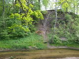 |
The Vilce Nature Park is small in size and exists alongside the deep valleys of the Vilce River and its tributaries. Biotopes include visible sandstone cliffs, rapids on the rivers, forests typical of such areas, and the plants and animals that are found therein. The well-appointed Vilce castle hill is next to the Zaķu meadow, which is a nicely appointed and popular place for recreation. |
|
|
|
Uzcelts Kaņiera pilskalnā un ir Kaņiera pilskalna takas sastāvdaļa. No torņa paveras izcila Kaņiera ezera dienvidrietumu daļas ainava ar niedru saliņām un nelieliem atklāta ūdens laukumiem. Laba putnu vērošanas vieta. |
|


