
| Nr | Nosaukums | Apraksts |
|---|---|---|
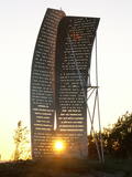 |
Ošvalkos – apdzīvotā vietā starp Jūrkalni un Sārnati ir uzstādīta piemiņas zīme "Cerību bura”, kas veltīta tiem latviešu bēgļiem (1944. - 1945. g.), kas pāri Baltijas jūrai uz Zviedriju devās zvejas laivās. Zīme izvietota krasta kāpās starp ceļu un jūru. |
|
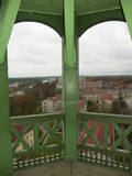 |
No Sv. Sīmaņa luterāņu baznīcas torņa labi saskatāma Valmieras centrālā daļa un Gaujas krasti. Skaidrā laikā redzams Zilais kalns. Apskatāmas arī baznīcā esošās kultūrvēsturiskās vērtības un vienas no Latvijas skanīgākajām ērģelēm.
|
|
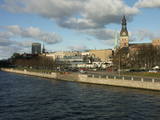 |
Klasiskais Vecrīgas siluets baudāms no vairākām vietām: Mūkusalas ielas (starp Dzelzceļa un Akmens tiltu), Akmens tilta, A – B dambja, atpūtas vietas pie Hansabankas centrālā biroja, Vanšu tilta un Balasta dambja Ķīpsalā. Savienojot šīs vietas sanāks labs kājnieku vai velomaršruts. Savādāki skati pavērsies no kuģīšiem, kas sezonas laikā kursē pa Daugavu.
|
|
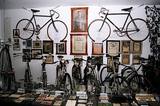 |
Tēva un dēla Jāņa un Gunta Sereginu velosipēdu kolekcija, kas ir vienīgā seno velosipēdu kolekcija Latvijā un lielākā Baltijā, jau vairākus gadus apskatāma pašu radītā muzejā. Seno velosipēdu kolekcija komplektēta no tehniski interesantākajiem Latvijā atrastajiem velosipēdu attīstības vēstures paraugiem. Kopumā muzejā atrodas aptuveni 70 Latvijā izgatavotu un lietotu velosipēdu. Līdz ar velosipēdiem muzejā plaši pārstāvētas dažādas lietas, kas saistītas ar velosipēdu lietošanu, riteņbraukšanas sportu, riteņbraukšanas biedrībām un velosipēdu ražošanu. Ekspozīcijā aplūkojama arī velosipēdu firmas zīmju lielākā kolekcija Austrumeiropā ar vairāk nekā 1000 emblēmu no visas pasaules. Ekskursijas pieejamas gida pavadībā. |
|
 12 dienas
|
This tour offers seeing the capital cities and most attractive towns of Lithuania, Latvia and Estonia through the freedom of independent travel and using public train and bus services. Getting around in cities and towns is easy, either by walking, or by using local public transport or taxis. The Old Town of Vilnius is in the UNESCO World's Cultural Heritage list. Daugavpils Fortress and the museum of Mark Rothko, the world famous abstractionist, are two highlights of Daugavpils city, Rēzekne city is known as the heart of Latgale region. Riga, the capital city of Latvia, offers a variety of cultural experiences and entertainment. Sigulda is famous for its landscapes and medieval castles. Cēsis is one of the most charming towns in Latvia with many attractions ranging from medieval heritage to nice restaurants, exhibitions and festivals. Valmiera offers art galleries, museums, nature trails and Valmiermuža beer from the famous local brewery. Tartu in Estonia is a university town, with some very popular tourist attractions such as the interactive AHHAA science centre, the largest in Baltic countries. Narva is a border town overlooking the Ivangorod fortress in Russia across the river Narva. Finish the tour in Tallinn – the capital city of Estonia. Tourist information centres in cities and towns will help you with maps, information on sights, attractions and guided tours, food, shopping and public transport. |
|
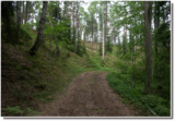 |
Aiz Krāču kalniem (Krāckalni) otrs
izteiktākais nacionālā parka kāpu veidojums, kas vairāk
nekā trīs kilometru garumā atdala Raganu no Zaļā purva.
Tā piekājē izlokas sens zemes ceļš, pa kuru iet
veicamais maršruts. Ejot pa Zaļo kāpu lūdzam iet tikai
pa jau iestaigātām takām!
|
|
 |
Operdziedātāja Jāņa Zābera muzejs "Vecais ceplis" atklāts 1973. gada 11. augustā - dziedātāja dzimšanas dienā - viņa dzimtajās mājās. Muzejā apskatāmas fotogrāfijas no viņa dzīves gājuma, afišas un operu tērpi. Tāpat pieejami dziesmu un operu āriju ieraksti mākslinieka izpildījumā. Muzeju pārzina Jāņa Zābera brāļa meita ar ģimeni. To ir iespējams apmeklēt, iepriekš saskaņojot laikus.
|
|
 |
Daugavas ielejas dabas parks ir vienīgā vieta, kur starp Daugavas HES ūdenskrātuvju kaskādēm vēl salīdzinoši īsā upes posmā saglabājusies Daugavas ieleja un tās sānu pieteku gravas tādas, kādas tās apmēram izskatījās pirms teritorijas appludināšanas. Īpaši skaisti skati paveras no Daugavas labā pamatkrasta nogāzes pie Aizkraukles baznīcas un pilskalna. Nogāžu meži, pļavas, avotu izplūdes vietas un nelielie dolomīta atsegumi ir aizsargājami biotopi. Aizkraukles pilskalnā izveidota atpūtas vieta. Netālu no tā apskatāmas arī Aizkraukles pilsdrupas. |
|
 |
Kafejnīca "Gaļas nams" atrodas Jēkabpils centrālajā daļā. Cep picas, smalkmaizītes, kūkas, tortes un kliņģerus. Piedāvā kūpinājumus, brieža un mežacūkas delikateses, vietējo mājražotāju un zemnieku produktus. |
|
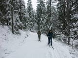 |
Dabas parks, kas atrodas Ogres pilsētas ziemeļrietumu daļā, ir populāra ogrēniešu atpūtas, pastaigu, bet ziemā – distanču slēpošanas vieta. Parka lielāko daļu aizņem ar skujkoku mežiem apaugusi osu grēda (ledāja radīts veidojums – gara, salīdzinoši šaura pauguru virkne ar stāvām nogāzēm), kas ir nozīmīga daudzu augu sugu dzīves vieta. Viens no osu grēdas izteiktākiem pauguriem ir Jaunogres pilskalns - ar slēpēm un ragaviņām iecienīta nobraucienu vieta. |
|
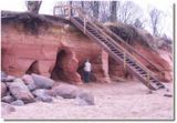 |
Ainavisks jūras viļņu izskalots smilšakmens atsegums
dienvidos no Zaķupes ietekas.
|
|
 |
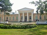
Ēka, kuru uzcēla 1933. g., ir
viena no Latvijas spilgtākajām nacionālā
romantisma celtnēm. Tā sākotnēji kalpoja kā
plašākā apkārtnē pazīstamais restorāns
“Jautrais ods”. Pēc 2. Pasaules kara ēkā tika
izveidota bērnu sanatorija “Meža māja”.
1997. g. līdz ar Ķemeru nacionālā parka
izveidi Meža māja kļuva par parka
administrācijas ēku un vienlaikus arī par
modernu parka apmeklētāju centru, un norises
vietu dažādiem vides izglītības pasākumiem.
|
|
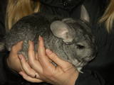 |
Saimnieki audzē šinšillas (to izcelsme meklējama Dienvidamerikas Andu kalnos). Piedāvā ekskursiju un stāstījumu par šinšillu dzīvi un audzēšanu, dzīvnieku un ādu iegādi. Saimniece glezno. |
|
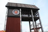 |
Tāpat kā Ventspils Rātslaukums, arī Tirgus laukums ir uzskatāms par pilsētas vēsturiskā centra nozīmīgu daļu, kura apkaimē ir saglabājies senais ielu plānojums. Kādreizējā Rātsnama vietā tagad slejas kariljonu zvana pulksteņu tornis. Tas zvana katru stundu, bet 12:33:44 un 00:33:44 ar īpašu melodiju ieskandina astronomisko Ventspils laiku. Tirgus laukumā ir aka, kas saulainā laikā darbojas arī kā Saules pulkstenis. Monētu automātā var izkalt īpašu piemiņas monētu. |
|
 |
"Māras drava" atrodas vienā no Ziemeļlatgales neskartās dabas stūrīšiem. Piedāvājumā bišu mātes jau no pavasara un vēlāk gan jaunas, gan ražojošas bišu saimes, propolisa un vaska maisījuma sveces, bišu maize un propoliss sviestā. Darbnīcā izgatavo bišu stropus un citu dravas aprīkojumu. |
|
 |
Ungurmuižas parkā, kas ir slavens ar izcilajiem un resnajiem dižozoliem, kuru aprupējošie stumbri, dzīvā un mirusī koksne ir daudzu sugu, t.sk. jau Eiropā izzudušu vienīgā mājvieta, ir izveidota dižkoku taka. Garums 1,3 km, laiks līdz 1 h. Parkā atrodas Latvijā vienīgā līdz mūsdienām saglabājusies 18. gs. sākuma koka pils u.c. kulūrvēsturiskas vērtības
|
|
 |
Renavas parks (izveidots 19.gs.) ir viens no reprezentatīvā tipa Lietuvas parkiem, saglabājis pirmatnējās dabas skaistumu. Nelielā muižas parka parterī līdz mūsdienām saglabājušies ne mazums eksotisku koku. Parka ziemeļu daļā un meža parkā dominē kļavas, liepas, oši, egles, ozoli u.c. Parka lepnums – resnākā Lietuvas egle, kuras diametrs ir 1,2 metri; tāpat arī liepa, uz kuras nolīkušā stumbra izaugušie seši zari izveidojušies par pastāvīgiem vertikāliem stumbriem. Parkā ieved vīteņaugiem apstādītā lapene. |
|
 |
Muzeja krājumu veido vairāk nekā 40 tūkstoši dažādu priekšmetu, kas atspoguļo Ogres novada kultūrvēsturisko mantojumu no vissenākajiem laikiem līdz mūsdienām. Ekspozīcija "Pietura Ogre" piedāvā izsmeļošu vēstījumu par Ogres vēsturi, sākot no laika, kad Ķentes pilskalnā apmetās pirmie tā iemītnieki līdz Ogres kūrorta zelta laikiem un padomju periodam, kura laikā Ogre no peldu un atpūtas kūrorta pārvērtās par visā Austrumeiropā zināmu rūpniecības centru. Muzeja pirmā stāva zālē izstādes mainās ik mēnesi. Tematiskās izstādes veltītas dažādiem vēstures notikumiem un norisēm, bet mākslas izstādēs sevi prezentē Latvijas un Ogres novada mākslinieki. Muzejā notiek pasākumi un koncerti, muzejpedagoģiskās programmas un radošās darbnīcas. Iespējams pieteikt ekskursiju pa Ogres pilsētu. |
|
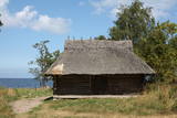 |
Altjas vēsture iestiepjas 15. gs. vidū. Altja ir sens zvejniekciems, kur jūras krastā ir apskatāmi pirms gandrīz četrdesmit gadiem atjaunotie šķūņi, kur zvejnieki glabāja tīklus un citu inventāru. Mūsdienās šķūņiem ir vairāk ainaviska vērtība, jo tie netiek izmantoti. Turpat meklējama akmeņu kaudze, kur ikviens var atstāt savu akmeni ar iedomātu vēlēšanos. Noteikti ir apmeklējams Altjas krogs (Altja kõrts) – no guļbaļķiem celta ēka ar niedru jumtu, kur var nobaudīt Igaunijas nacionālos ēdienus. Ja iepazīta Altja, var doties pārgājienā pa Oandu taku. Tai ir dažāda garuma posmi – sākot ar dažus kilometrus garo Altjas apkārtnes izziņas taku (3 km) un 0,7 km garo Bebru taku (Koprarada), līdz pat 79 km garajam vairākdienu Kirves (Kõrve) pārgājienu maršrutam. |
|
 2 dienas
|
Latvija ir ābolu zeme, tāpēc radīt sidru šeit ir dabiski! Senās ābolu audzēšanas tradīcijas mūsu zemē, kā arī kvalitatīvu šķirņu daudzveidība ir būtiska Latvijas sidra kultūras priekšrocība. Mūsu klimata zonā ir sarežģīti izaudzēt labas vīnogas, lai ražotu vīnu, toties vietējie apstākļi ir īpaši piemēroti, lai taptu ābolu sidrs. Tā ir dabiska likumsakarība, ko vietējie sidra ražotāji izmanto ar pieaugošu izcilību. Sidra ceļš jūs aizvedīs uz dažādām Latvijas sidra darītavām, kā arī restorāniem un krodziņiem, kas ceļ to galdā. Sidra ceļš ļaus izprast Latvijas sidra specifiku, iepazīstinās ar kulinārajām tradīcijām un kultūras mantojumu dažādos reģionos. Jums būs iespēja tikties ar pašiem sidrdariem, kas vada nelielas saimniecības, rūpējas par dārzu, pastāstīs par savu darbu vai pat ļaus tajā piedalīties. |
|


