
Dabas objekti Lietuvā
Ar ko ievērojama daba Lietuvā?
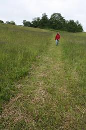
Kuršu kāpa – tuksnešaina zemes strēle starp Baltijas jūru un Kuršu jomu, Žemaitijas pauguraines ainavas, Aukštaitijas ezeru zilo spoguļu labirinti, Dzūkijas priežu sili, Nemunas ielejas loku ainavas un daudzie reģionālie dabas parki, kas veidoti ne tikai dabas aizsardzības, bet arī sabiedrības izglītošanas un atpūtas nolūkos, ir tie dabas vērtumi, kas dabas tūristus piesaista Lietuvā.
Lai uzzinātu vairāk par apmeklējamām teritorijām aicinām izmantot vides vai vietējo gidu pakalpojumus.
Esiet saudzīgi pret dabu ceļojuma laikā - ievērojiet Zaļos padomus!
| Pārskats | Detaļas |
|---|---|
 |
Lietuva
Meteļu reģionālais parksParka centrā atrodas trīs lieli ezeri – Dusia, Metelys un Obelija. Dusia ezera (ļoti dzidrs ūdens ar labu caurredzamību) pludmales tā D un DA krastā ir iecienītas atpūtas un peldvietas. Ezeri ar tiem pieguļošajiem mitrājiem ir nozīmīga putnu atpūtas vieta migrāciju laikā.
PakalpojumiPakalpojumi - atpūta
VelomaršrutsVelomaršruts apkārt Dusia ezeram (25 km), apkārt Metelys ezeram (27 km). 
Dabas takaIzziņas taka Bijotų un Širvinto mežā (4 km). 
Dabas vērošanaPutnu vērošana ezeru piekrastē migrācijas laikā. Skats no Prelomčiškė pilskalna un skati no Seirijai – Meteliai ceļa. Informācija: www.meteliuparkas.lt. |
 |
Lietuva
Neres reģionālais parksTeritorija veidota ainaviskās Neres vidusteces ainavas, sugu un Lietuvas lielākā ozolu meža aizsardzībai.
PakalpojumiPakalpojumi - atpūta
Izbraukumi ar kuģīti/laivu2 dienu brauciens ar laivu pa Neri: Grigiškės - Kernavė.
VelomaršrutsNeres tūrisma maršruts upes kreisajā krastā (23 km).
Dabas takaDūkštos ozolu meža taka (2,3 km), Dūkštos pastaigu taka (5 km).
Dabas vērošanaSkats no skatu torņa, kur 108. ceļš nolaižas pa Neres labo krastu upes ielejā. Informācija: www.neriesparkas.lt. |
 |
Lietuva
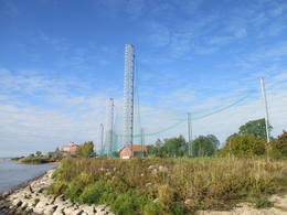
Ventė ragsPutnu gredzenošanas stacija un putnu vērošanas vieta.  333 333
Pakalpojumi
333km - Attālums no valsts galvaspilsētas |
 |
Lietuva
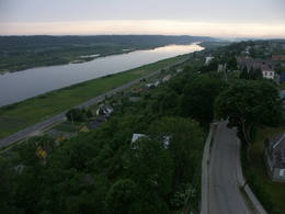
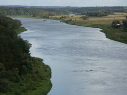
Panemuņu reģionālais parksParka teritorija ietver Lietuvas lielākās upes – Nemunas ielejas daļu starp Seredžius un Geldaudišķis ciemiem ar ļoti ainaviskiem skatiem uz tās krastos esošajiem pilskalniem, viduslaiku pilīm, muižām u.c.
Pakalpojumi
156km - Attālums no valsts galvaspilsētasPakalpojumi - atpūta
VelomaršrutsVelomaršruts- Seredžius – Jurbarkas (47 km).
Dabas vērošanaSkatu vietas no Seredžius pilskalna, Veliuona pilskalna un baznīcas. Apmeklētāju centrs atrodas Šilinė. Informācija: www.prpd.lt. |
 |
Lietuva
Dzūkijas nacionālais parksDzūkijas Nacionālais parks dibināts 1991. gadā. Tā ir lielākā Lietuvas īpaši aizsargājamā dabas teritorija un viens no mežainākajiem valsts apvidiem. Nacionālais parks ir bagāts ar upēm, kuru krastos nereti redzami iespaidīgi nogulumiežu atsegumi, kā arī simtiem avotu un avoksnāju. Starp vērtīgiem biotopiem pieminamas arī pļavas un palieņu pļavas, purvi u.c. mitrāji. Kopumā parkā konstatētas gandrīz 2000 augu sugas un 2108 dzīvnieku sugas, kukaiņus u.c. ieskaitot. Viena no nozīmīgākajām kultūrvēstures vērtībām ir etnogrāfiskie ciemi un saglabātās biškopības, amatniecības, arhitektūras, kulinārās u.c. Cilvēki izsenis dzīvojuši saskaņā ar dabu un izmantojuši tās bagātības – ogas, sēnes, bišu medu, tīro avotu un upju ūdeni un piekopuši dažādu amatu un biškopības tradīcijas. Pazīstama Dzūku tradīcija ir sēņu un ogu vākšana plašajos mežos. Parkā ir izveidoti kājāmgājēju, velotūrisma un ūdenstūrisma maršruti. Apmeklētāju centri atrodas Merķines (Merkinė) pilsētā un Marcinkoņa (Marcinkonys) ciemā. Pakalpojumi
110km - Attālums no valsts galvaspilsētasPakalpojumi - atpūta
Izbraukumi ar kuģīti/laivu1 - 2 dienu brauciens pa Ūla (nepieciešamas atļaujas, kuras var dabūt Marcinkonys apmeklētāju centrā) līdz ietekai Merķē (Merkys) un pa Merķi līdz Merkinė.
VelomaršrutsVelomaršruts- Marcinkonys – Puvočiai – Mardasavas – Mančiagirė (vai Zerviynos) – Marcinkonys (līdz 40 km).
Dabas vērošanaPutnu vērošana Dzūkijas mežos. Skatu vietas no Ūla atseguma, Liškiava un Merkinė pilskalniem. Apmeklētāju centrs atrodas Marcinkonys un Merkinė. Informācija: www.dzukijosparkas.lt. |
 |
Lietuva
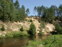
Nemunas loku reģionālais parksNemunas loku reģionālais parks (Nemuno kilpų regioninis parkas) ir dibināts 1992. g. un tā mērķis ir augu, dzīvnieku, ainavas un ģeoloģisko dabas pieminekļu aizsardzība. Parks ietver piecus lielus Nemunas upes lokus, kuru centrā atrodas Birštonas – viens no nozīmīgākajiem Lietuvas kūrortiem. Nemunas loku stāvajos krastos vietām redzami iespaidīgi nogulumiežu atsegumi. No dabas daudzveidības un ainavas viedokļa nozīmīgas ir arī Nemunas pieteku dziļās gravas. Parkā sastopami veci nogāžu un gravu meži. Punes (Punia) un Prienu (Prienai) mežos aug Lietuvā augstākie koki. Kopumā parkā ir konstatētas 973 augu un 1713 dzīvnieku (zīdītāji, putni, abinieki, rāpuļi, kukaiņi u.c.) un 505 sēņu sugas. Kā nozīmīgi kultūras tradīciju turpinātāji ir jāpiemin Prienu kokapstrādes meistari, kas gatavo koka krustus. Pakalpojumi
91km - Attālums no valsts galvaspilsētasPakalpojumi - atpūta
Izbraukumi ar kuģīti/laivu2 dienu laivu brauciens Alytus - Birštonas.
VelomaršrutsVelobrauciens pa Žvėrinčius meža takām (15 km).
Dabas takaPārgājiens pa Velniabliūdis izziņas taku (1,5 km) un Škėvoniai izziņas taku (1,6 km).
Dabas vērošanaSkatu vietas no Balbieriškis un Škėvonis atsegumiem, Punia un Rumbanių pilskalniem. Informācija: www.nemunokilpos.lt. |
 |
Lietuva
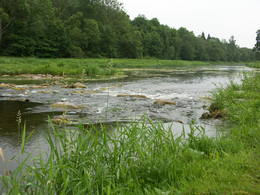
Dubīsas reģionālais parksDubīsas reģionālais parks (Dubysos regioninis parkas) dibināts 1992. gadā. Veidots Dubīsas upes ainaviskās senlejas aizsardzībai. Dubīsa – viena no populārākajām Lietuvas ūdenstūristu upēm (liels kritums, straujteces, ainaviski krasti). Tas aptver iespaidīgo Dubīsas ieleju, kuras dziļums sasniedz līdz pat 40 m, bet platums – līdz puskilometram. Skaistās ielejas nogāzes pāršķeļ dziļās sānu pieteku gravas. Šeit sastopami tādi nozīmīgi un Eiropas mērogā aizsargājami biotopi kā sausi zālāji kaļķainās augsnēs, sugām bagātas ganības un ganību pļavas, kuras apsaimnieko vietējie mājlopi, mēreni mitras pļavas, veci un dabiski boreālie (ziemeļu) meži, nogāžu un gravu meži un ozolu meži. Šeit kopumā konstatētas 805 augu sugas, 922 dzīvnieku sugas, no kurām daudzas ir aizsargājamas un reti sastopamas Lietuvas un Baltijas mērogā. Šejienes neparastais dabas skaistums ir ietekmējis senās pagānu tradīcijas – Betīgalā (Betygala) dzīvojis pēdējais pagānu priesteris Gintautas, kuru sauca par krīvu krīvu (krivių krivaitis). Tā dēvēja senos baltu tautu galvenos priesterus. Slavenā lietuviešu dzejnieka Mairoņa (1862. – 1932.) sētā ir izveidots etnogrāfiskais muzejs. Parka apmeklētāju centrs atrodas Kaulakiai ciemā. PakalpojumiPakalpojumi - atpūta
Izbraukumi ar kuģīti/laivuBrauciens ar lavu- 1 dienas brauciens no Raseiniai – Baisogala ceļa tilta līdz Ariogala tiltam. Informācija: www.dubysa.info. |
 |
Lietuva
Žagares reģionālais parksŽagares reģionālais parks organizē dažādas ekskursijas, izglītojošas programmas bērniem un senioriem un jauniešu nometnes. Žagare jau sen ir pazīstama ar savu īpašo ķiršu šķirni, kuru Latvijā pazīst ar nosaukumu ‘Latvijas zemais’, bet lietuvisko nosaukumu varētu tulkot kā ‘Žagares ķirši’. Tai ir vairākas variācijas, kas atšķiras ar dažādu nogatavošanās laiku, ražīgumu, augļu koku formu un citam pazīmēm. Līdz pat mūsdienām šie ķirši aug gandrīz ikvienās mājās un ir kā ekskluzīvs Žagares simbols. |
 |
Lietuva
Botānikas takaKaut arī Augštaitijas nacionālo parku uzskata par floristiskā ziņā ļoti bagātu teritoriju, šī ir vienīgā vieta, kur varam iepazīt augu valsts bagātību. To īstenot palīdz takas malās izvietotie informācijas stendi. 3,8 km garās lokveida takas sākums ir meklējams Palūšē, Lūšu (Lūšiai) ezera galējā austrumu punktā. Taka ved gar ezera krastu, mežainām kāpām, nelielu strautu ielejām un pa purvāju. Nenomaldīties palīdz krāsu marķējums uz koku stumbriem. 113
Pakalpojumi
113km - Attālums no valsts galvaspilsētas |
 |
Lietuva
Kauņas jūras reģionālais parksKauņas jūras reģionālais parks (Kauno marių regioninis parkas) dibināts 1992. gadā. Tas ietver Nemunas HES uzpludināto posmu – lielāko Lietuvas ūdenskrātuvi no Kauņas līdz Piļonas (Piliuona) ciemam. Viena no nozīmīgākajām parka vērtībām ir ainava, kas veidojusies ilgā cilvēka un dabas mijiedarbībā. Parkā konstatētas 950 augu sugas, 600 dzīvnieku, t.sk. - 34 zivju sugas. Parka nozīmīgas dabas vērtības ir meži, augstie purvi, kadiķu audze. Parkā ir apskatāmi dažādu vēsturisko periodu liecinieki – senču pilskalni, Pažaislis klosteris, Kauņas cietokšņa Piektais forts, kā arī Rumšišķes (Rumšiškės) brīvdabas muzejs – viens no lielākajiem (195 ha) šāda veida muzejiem Eiropā. Vaišvīdavā (Vaišvydava) ir izveidots parka apmeklētāju centrs, parkā ir dabas takas, piemēram, Žiegždriai ģeoloģiskā taka un Dubravos izziņas taka.  111
111
Pakalpojumi
111km - Attālums no valsts galvaspilsētas |
 |
Lietuva
Aukštadvara reģionālais parksPauguriem un ezeriem bagāta teritorija Dzūkijas augstienes Z daļā. Interesantākā tūristu piesaiste ir Velna dobe (Velnio duobė) – līdz 40 m dziļa un līdz 200 m plata piltuvveida bedre, kuras izcelsmi vairumā gadījumu saista ar ledāja darbību.
Pakalpojumi
56km - Attālums no valsts galvaspilsētasPakalpojumi - atpūta
Dabas takaPārgājiens pa Velna dobi – Baltijā iespaidīgāko šāda tipa ģeoloģisko veidojumu.
Dabas vērošanaSkatu vieta no Aukštadvara pilskalna. Informācija: www.aukstadvaris.lt/parkas.htm. |
 |
Lietuva
Traupja botāniskais dārzsVienīgo skolas botānisko dārzu Lietuvā sāka iekopt 1989. gadā Traupja skolā. Visas augu kolekcijas (kopumā Traupja botāniskajā dārzā aug jau vairāk nekā 8000 augu sugu, formu un šķirņu) ir savācis viens cilvēks – S. Obelevičus. 
 4-9 4-9


Pakalpojumi
4-9 Aktīvie sezonas mēnešiPakalpojumi - citi
Pieņem tūristu grupas
Pieņem individuālus apmeklētājus
Vieta ar konkrētu darba laiku, kas jānoskaidro iepriekš
Apmeklējums iepriekš jāpiesaka |
 |
Lietuva
Šarneles (Zviedru) pilskalns (Šarnelės (Švedų) piliakalnis)Viens no iespaidīgākajiem nacionālā parka pilskalniem, kura piekājē atradusies senpilsēta. Arheoloģisko izrakumu gaitā te atrastas kuršu senlietas. Tiesa, mežs un biezais augājs traucē uztvert šī nozīmīgā arheoloģijas pieminekļa patiesos apjomus un formu. Uz pilskalnu vasarās ved izpļauta taka. Ja esat Žemaišu Kalvarijas pusē un atliek brīvs brīdis, tad savā maršrutā var iekļaut arī šo apskates objektu. 317
Pakalpojumi
317km - Attālums no valsts galvaspilsētas |
 |
Lietuva
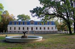
Salu muižas parksDviragio ezera salā atrodošie Salu muiža un parks no putna lidojuma atgādina Lietuvas kartes aprises. Muižas saimniecības austrumu pusē esošais parks – jaukta plānojuma. Tas ir viens no senākajiem parkiem Lietuvā. Vēl Radviļiem saimniekojot, te bija meža parks, kurā koki netika cirsti. Parkā valdīja vietējo sugu lapu koku – kļavas, liepas, oši, apses, kuri šobrīd jau ir divi simtu gadu veci. Uz ezera pusi stiepjošā taka savieno aleju ar parka taku pie ezera. Līdz mūsdienām ir saglabājušies apstādījumi, aleju fragmenti. 1-12
Pakalpojumi
1-12 Aktīvie sezonas mēnešiPakalpojumi - citi
Pieņem tūristu grupas
Pieņem individuālus apmeklētājus
Vieta ar konkrētu darba laiku, kas jānoskaidro iepriekš
Apmeklējums iepriekš jāpiesaka |


