
Dabas objekti Lietuvā
Ar ko ievērojama daba Lietuvā?
Kuršu kāpa – tuksnešaina zemes strēle starp Baltijas jūru un Kuršu jomu, Žemaitijas pauguraines ainavas, Aukštaitijas ezeru zilo spoguļu labirinti, Dzūkijas priežu sili, Nemunas ielejas loku ainavas un daudzie reģionālie dabas parki, kas veidoti ne tikai dabas aizsardzības, bet arī sabiedrības izglītošanas un atpūtas nolūkos, ir tie dabas vērtumi, kas dabas tūristus piesaista Lietuvā.
Lai uzzinātu vairāk par apmeklējamām teritorijām aicinām izmantot vides vai vietējo gidu pakalpojumus.
Esiet saudzīgi pret dabu ceļojuma laikā - ievērojiet Zaļos padomus!
| Pārskats | Detaļas |
|---|---|
 |
Lietuva
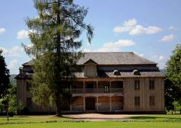
Rietavas muižas parksRietavas parks bijis lielākais ainaviskais parks Lietuvā. Tas izveidots 1848. – 1855. gados dabiski izretinātjā mežā, rekonstruēts – 1904. – 1905. gadā. Parks ir jaukti plānots. Lielā parka augu valsti veido vietējie krūmi un koki, tajā pašā laikā te aug arī vairāki citzemju augi. No tiem laikiem saglabājušās dažas koku alejas, žoga fragmenti, Baltie un Sarkanie vārti, sarga būdiņa. Parkā ir sarežģīta ūdens krātuvju sistēma – daži dīķi, Jūras upes līkums, vecupes apjosta sala.  1-12 1-12


Pakalpojumi
1-12 Aktīvie sezonas mēnešiPakalpojumi - citi
Pieņem individuālus apmeklētājus
Pieņem tūristu grupas
Vieta ar konkrētu darba laiku, kas jānoskaidro iepriekš |
 |
Lietuva
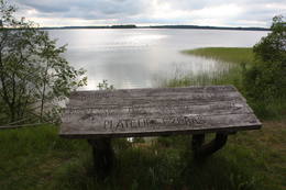
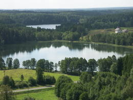
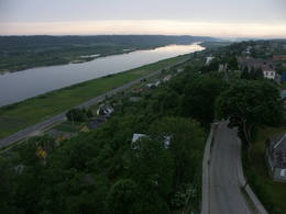
Plateļu ezers (Platelių ežeras)Nacionālā parka galvenā ainavas dominante. Ezers ir ~ 8,4 km garš un līdz 3,3 km plats. Tā austrumu krasti pārsvarā ir ar mežiem apauguši, ziemeļrietumu krasts – purvains, bet rietumu krastā parādās apdzīvotas sētas un simpātiskā Plateļu (Plateliai) pilsētiņa, kur meklējamas skaistākās skatu vietas. Ezera krastos ir labi attīstīta infrastruktūra - tūristu mītnes, ēdināšanas uzņēmumi (Plateļos), ūdenssporta un atpūtas inventāra noma. Ūdens dzidruma dēļ, Plateļu ezeru ir iecienījuši zemūdens niršanas entuziasti. Ezerā ir vairākas salas, no kurām interesanta ir Pils salas (Pilies sala), uz kuras no 15. – 16. gs. atradās muiža. Pastāv uzskats, ka senie Plateļu apkārtnes iedzīvotāji sākotnēji ir dzīvojuši uz salas, kuru ar krastu savienojis uz pāļiem celts tilts. Jāpiemin, ka 15 gs. pirmoreiz pieminētā Plateļu pilsētiņa atradusies uz Šventorkalņa (Šventorkalnis) kalna. Apkārt Plateļu ezeram ir izveidots ~ 24 km garš velomaršruts. Tā ir ļoti laba iespēja iepazīt parku videi un ceļotāja veselībai draudzīgā veidā.  307 307
Pakalpojumi
307km - Attālums no valsts galvaspilsētas |
 |
Lietuva
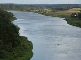
Nemunas loku reģionālais parksNemunas loku reģionālais parks (Nemuno kilpų regioninis parkas) ir dibināts 1992. g. un tā mērķis ir augu, dzīvnieku, ainavas un ģeoloģisko dabas pieminekļu aizsardzība. Parks ietver piecus lielus Nemunas upes lokus, kuru centrā atrodas Birštonas – viens no nozīmīgākajiem Lietuvas kūrortiem. Nemunas loku stāvajos krastos vietām redzami iespaidīgi nogulumiežu atsegumi. No dabas daudzveidības un ainavas viedokļa nozīmīgas ir arī Nemunas pieteku dziļās gravas. Parkā sastopami veci nogāžu un gravu meži. Punes (Punia) un Prienu (Prienai) mežos aug Lietuvā augstākie koki. Kopumā parkā ir konstatētas 973 augu un 1713 dzīvnieku (zīdītāji, putni, abinieki, rāpuļi, kukaiņi u.c.) un 505 sēņu sugas. Kā nozīmīgi kultūras tradīciju turpinātāji ir jāpiemin Prienu kokapstrādes meistari, kas gatavo koka krustus. Pakalpojumi
91km - Attālums no valsts galvaspilsētasPakalpojumi - atpūta
Izbraukumi ar kuģīti/laivu2 dienu laivu brauciens Alytus - Birštonas. 
VelomaršrutsVelobrauciens pa Žvėrinčius meža takām (15 km). 
Dabas takaPārgājiens pa Velniabliūdis izziņas taku (1,5 km) un Škėvoniai izziņas taku (1,6 km). 
Dabas vērošanaSkatu vietas no Balbieriškis un Škėvonis atsegumiem, Punia un Rumbanių pilskalniem. Informācija: www.nemunokilpos.lt. |
.JPG?size=260) |
Lietuva
Traķu vēsturiskais nacionālais parksParks veidots g.k. daudzveidīgā kultūrvēsturisko objektu klāsta aizsardzībai (Traķu ezerpils, Seno Traķu klosteris, Užutraķu pils, Bražoles pilskalns, karaīmu mantojums u.c.).
Pakalpojumi
28km - Attālums no valsts galvaspilsētasPakalpojumi - atpūta
Izbraukumi ar kuģīti/laivu1 dienas brauciens pa Totoriškių, Galvė, Skaistis un Luka ezeriem.
VelomaršrutsVelomaršruts- Trakai – Totoriškės – Raudonė I – Kariotiškės – Rubežius – Trakai (līdz 25 km).
Dabas takaVarnikai izziņas taka (3,5 km).
Dabas vērošanaSkatu vieta Galvė ezera Z daļā. Apmeklētāju centrs atrodas Traķos. Informācija: www.seniejtrakai.lt. |
 |
Lietuva
Neres reģionālais parksTeritorija veidota ainaviskās Neres vidusteces ainavas, sugu un Lietuvas lielākā ozolu meža aizsardzībai.
PakalpojumiPakalpojumi - atpūta
Izbraukumi ar kuģīti/laivu2 dienu brauciens ar laivu pa Neri: Grigiškės - Kernavė.
VelomaršrutsNeres tūrisma maršruts upes kreisajā krastā (23 km).
Dabas takaDūkštos ozolu meža taka (2,3 km), Dūkštos pastaigu taka (5 km).
Dabas vērošanaSkats no skatu torņa, kur 108. ceļš nolaižas pa Neres labo krastu upes ielejā. Informācija: www.neriesparkas.lt. |
 |
Lietuva
Seredžiaus pilskalnsViens no ainaviskākajiem Nemunas pilskalniem ar skaistu skatu uz upes ieleju. 13. – 14. gs. šeit atradās militārs nocietinājums (nav saglabājies). 145
Pakalpojumi
145km - Attālums no valsts galvaspilsētas |
 |
Lietuva
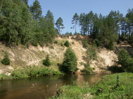
Ventas reģionālais parksVeidots Ventas upes ielejas un tās pieteku krastu ainavas aizsardzībai. Papilē (Papilė) Ventas labā krasta nogāzē atrodas Baltijas mērogā unikālais un apskatei labiekārtotais Juras perioda atsegums (pazīstams kopš 1925. g.), kura slāņos atrastas un aprakstītas > 300 dažādas dzīvības formas.
PakalpojumiPakalpojumi - atpūta
Izbraukumi ar kuģīti/laivu1 – 2 dienu brauciens pa Ventu: Papilė – Mažeikiai.
Dabas takaTaka līdz Juras perioda atsegumam.
Dabas vērošanaSkats no Papiles pilskalna un skatu torņa. Informācija: www.ventosparkas.lt. |
 |
Lietuva
Dzūkijas nacionālais parksDzūkijas Nacionālais parks dibināts 1991. gadā. Tā ir lielākā Lietuvas īpaši aizsargājamā dabas teritorija un viens no mežainākajiem valsts apvidiem. Nacionālais parks ir bagāts ar upēm, kuru krastos nereti redzami iespaidīgi nogulumiežu atsegumi, kā arī simtiem avotu un avoksnāju. Starp vērtīgiem biotopiem pieminamas arī pļavas un palieņu pļavas, purvi u.c. mitrāji. Kopumā parkā konstatētas gandrīz 2000 augu sugas un 2108 dzīvnieku sugas, kukaiņus u.c. ieskaitot. Viena no nozīmīgākajām kultūrvēstures vērtībām ir etnogrāfiskie ciemi un saglabātās biškopības, amatniecības, arhitektūras, kulinārās u.c. Cilvēki izsenis dzīvojuši saskaņā ar dabu un izmantojuši tās bagātības – ogas, sēnes, bišu medu, tīro avotu un upju ūdeni un piekopuši dažādu amatu un biškopības tradīcijas. Pazīstama Dzūku tradīcija ir sēņu un ogu vākšana plašajos mežos. Parkā ir izveidoti kājāmgājēju, velotūrisma un ūdenstūrisma maršruti. Apmeklētāju centri atrodas Merķines (Merkinė) pilsētā un Marcinkoņa (Marcinkonys) ciemā. Pakalpojumi
110km - Attālums no valsts galvaspilsētasPakalpojumi - atpūta
Izbraukumi ar kuģīti/laivu1 - 2 dienu brauciens pa Ūla (nepieciešamas atļaujas, kuras var dabūt Marcinkonys apmeklētāju centrā) līdz ietekai Merķē (Merkys) un pa Merķi līdz Merkinė.
VelomaršrutsVelomaršruts- Marcinkonys – Puvočiai – Mardasavas – Mančiagirė (vai Zerviynos) – Marcinkonys (līdz 40 km).
Dabas vērošanaPutnu vērošana Dzūkijas mežos. Skatu vietas no Ūla atseguma, Liškiava un Merkinė pilskalniem. Apmeklētāju centrs atrodas Marcinkonys un Merkinė. Informācija: www.dzukijosparkas.lt. |
 |
Lietuva
Labanoras reģionālais parksViens no Lietuvas mežainākajiem un ezeriem (~ 285) bagātākajiem apvidiem ar plašām aktīvās un pasīvās atpūtas iespējām.
Pakalpojumi
82km - Attālums no valsts galvaspilsētasPakalpojumi - atpūta
Izbraukumi ar kuģīti/laivu1 – 2 dienu brauciens pa parka ezeriem un to savienojošiem strautiem.
Dabas takaPeršokšnai izziņas taka (4 km).
Dabas vērošanaEtnokosmoloģijas muzeja skatu tornis. Apmeklētāju centrs atrodas Labanoras ciemā. Informācija: www.labanoroparkas.lt. |
 |
Lietuva
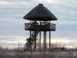
Rusnė salaSala Nemunas deltā. Entogrāfiskais muzejs, Uostadvaris bāka, putnu vērošanas tornis. 304
Pakalpojumi
304km - Attālums no valsts galvaspilsētas |
 |
Lietuva
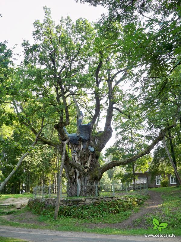
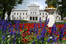
Pluņģes muižas parksPlunge ir slavena ar savu kunigaiša Oginska parku. Jauktā tipa 18. – 19. gadsimta parks izveidots žemaiču svētā meža - upurkalna vietā. Parka lepnums – viens no Lietuvas vecākajiem un lielākajiem – Pērkona ozols, leģendām apvītā Raudošā liepa, Piecstumbru osis. Pēc kunigaiša M. Oginska pavēles tika izrakti septiņi dīķi ar kaskādēm, kurus savieno akmens tiltu slūžas. Blakus plūstošā Babrungo upe piešķir parkam īpaši ainavisku skatu. 1-12
Pakalpojumi
1-12 Aktīvie sezonas mēnešiPakalpojumi - citi
Pieņem individuālus apmeklētājus
Pieņem tūristu grupas
Vieta ar konkrētu darba laiku, kas jānoskaidro iepriekš |
 |
Lietuva
Kurtuvenu muižas parksKurtuvenu muižas vietu apjož sens ģeometriski – ainaviski plānots parks. 19.gs. otrajā pusē tas bija ainaviskuma stilā ar dažādiem ģeometriskā parka elementiem. 4.2 ha lielajā parkā turpina ziedēt senās liepas, kļavas, oši, ozoli, citi dekoratīvie koki un krūmi – kopā vairāk nekā 20 šķirņu pārkoksnējušies augi.
1-12
Pakalpojumi
1-12 Aktīvie sezonas mēnešiPakalpojumi - citi
Pieņem tūristu grupas
Pieņem individuālus apmeklētājus
Vieta ar konkrētu darba laiku, kas jānoskaidro iepriekš |
 |
Lietuva
Kurtuvēnu reģionālais parksKurtuvēnu reģionālais parks (Kurtuvėnų regioninis parkas) ir mežu, ūdeņu un mitrāju valstība. Parka reljefs ir izteikti paugurains, tādēļ tas nav ticis izmantots lauksaimniecības vajadzībām. Dabas apvidus, kurā nelielā teritorijā novērojamas daudzveidīgas reljefa formas – augsti pauguri, izteiktas upju ielejas, gravas, termokarsta piltuves, kontinentālas kāpas u.c. Te ir sastopami boreālie (ziemeļu) meži, staignāju meži un purvaini meži, sugām bagāti egļu meži, neskarti purvi, pārejas purvi un slīkšņas, avoti un avoksnāji, dažāda tipa zālāji, sausas un mitras pļavas. Kopumā parkā ir konstatētas 978 augu un 1475 dzīvnieku sugas. Kurtuvēnu apkaime ir populāra dažādu tradīciju svinēšanas vieta. Šeit atzīmē masļeņicu (iekļauta Lietuvas nemateriālā mantojuma sarakstā), vasaras un ziemas saulgriežus u.c. Kurtuvēni ir pazīstama ar zivsaimnieciskajām tradīcijām. Parka apmeklētāju centrs atrodas Kurtuvēnu muižas ratnīcā.
PakalpojumiPakalpojumi - atpūta
VelomaršrutsVelomaršruts Kurtuvenu apkārtnē. Informācija: www.kurtuva.lt.
Dabas takaVainagių meža taka (4,3 km), Juodlė izziņas taka (4,5 km). |
 |
Lietuva
Panemuņu reģionālais parksParka teritorija ietver Lietuvas lielākās upes – Nemunas ielejas daļu starp Seredžius un Geldaudišķis ciemiem ar ļoti ainaviskiem skatiem uz tās krastos esošajiem pilskalniem, viduslaiku pilīm, muižām u.c.
Pakalpojumi
156km - Attālums no valsts galvaspilsētasPakalpojumi - atpūta
VelomaršrutsVelomaršruts- Seredžius – Jurbarkas (47 km).
Dabas vērošanaSkatu vietas no Seredžius pilskalna, Veliuona pilskalna un baznīcas. Apmeklētāju centrs atrodas Šilinė. Informācija: www.prpd.lt. |


