
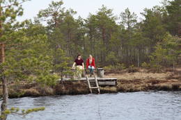
Dabas objekti Igaunijā

Ar ko ievērojama daba Igaunijā?
Iespaidīgākā Baltijas klinšu siena – t.s. Ziemeļigaunijas glints, „Līču zeme” – Lahemā ar nacionālo parku, „Salu zeme” – Sāremā sala un Monzunda salu arhipelāgs, Matsalu līcis kā viena no nozīmīgākajām masveida putnu atpūtas vietām migrāciju laikā, viens no izcilākajiem Eiropas meteorīta krāteriem, izcilākie Baltijas dižakmeņi un ūdenskritumi, Munameģis – Baltijas augstākā virsotne, Peipuss – piektais lielākais Eiropas ezers – ar senām zivju ieguves tradīcijām un ārkārtīgi lielā dabas daudzveidība, kas ir acīmredzami mainīga gan austrumu – rietumu, gan ziemeļu – dienvidu virzienā, ir tikai dažas no Igaunijas valsts dabas pievilcībām.
Lai uzzinātu vairāk par apmeklējamām teritorijām aicinām izmantot vides vai vietējo gidu pakalpojumus. Esiet saudzīgi pret dabu ceļojuma laikā - ievērojiet Zaļos padomus!
| Pārskats | Detaļas |
|---|---|
 |
Igaunija
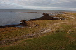
Putnu vērošanas tornis Puises ragāPuises ragā (Puise nina) ir uzcelts divstāvīgs atpūtas nams, kas apvienots ar putnu vērošanas torni. No tā paveras skats uz piekrasti, kas ir iecienīta migrējošo zosu atpūtas vieta. Šī ir privāta teritorija, kuras apskati vēlams saskaņot ar īpašnieku.  123 123
Pakalpojumi
123km - Attālums no valsts galvaspilsētas |
 |
Igaunija
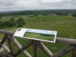
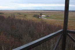
Torņa kalns (Tornimägi)Karulas augstienes augstākais reljefa punkts (137 m.vjl.), kas virs tuvākās apkārtnes paceļas par ~ 60 m. Torņa kalnā ir uzbūvēts skatu tornis ar ļoti plašu apkārtskatu. Uz tā platformas ir novietoti panorāmas fotoattēli, kuros atzīmēti zīmīgākie plašākā apkaimē redzamie objekti – apdzīvotas vietas, pilskalni, baznīcu torņi u.c. Turpat izveidota atpūtas vieta un meklējams Rebases ainavu takas sākums. 260
Pakalpojumi
260km - Attālums no valsts galvaspilsētas |
 |
Igaunija
Lemmjē pārgājienu taka (Lemmjõe matkarada)Taka, kas izveidota Lemmjegi (Lemmjõgi) un Raudnas (Raudna jõgi) satekas vietā, iepazīstina ar palieņu pļavām un veciem pārmitriem mežiem, kas ir vieni no lielākajiem Igaunijā. Takas sākumā dominē atklātas lauku ainavas. Viens no 4,9 km garās lokveida takas apskates objektiem ir Lemjē dižozols. Mitrā laikā noderēs ūdensizturīgi apavi. 155
Pakalpojumi
155km - Attālums no valsts galvaspilsētas |
 |
Igaunija
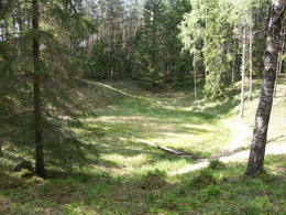
Ehijervs (Ähijärv)Karulas nacionālā parka lielākais ezers - 2,8 km garš, līdz 1 km plats. Ezera ziemeļaustrumu krastā atrodas parka apmeklētāju centrs. 5,5 m dziļais ezers ir gan zivīm, gan nostāstiem bagāta vieta. Ezera un tuvākās apkārtnes iepazīšanas nolūkā ir izveidota 3,5 km garā Ehijerva taka (Ähijärve teerada). Tās sākums atrodas pie iepriekš minētā apmeklētāju centra, kur izveidota atpūtas vieta un atraktīvs bērnu spēļu laukums. Taka sākumā ved gar ezera krastu, nelieliem mitrājiem un meža ceļiem, kas izmantoti iepriekšējos gadsimtos. |
 |
Igaunija
Suitsu tornis (Suitsu torn)Suitsu tornis celts 1979. g. kā pirmais Matsalu rezervāta metāla tornis. To atjaunoja 1998. g. Torņa augstums ir 21 m, tādēļ no tā paveras izcila dabas un kultūrainava uz Kazari deltas niedrājiem un blakus esošo Suitsu upi (Suitsu jõgi), kuras krastā ir uzceltas vairākas zvejnieku laivu būdas. |
 |
Igaunija
Ilumetsas meteorīta krāteriTrīs krāteri, no kuriem lielākā – Elles kapa (Põrguhaud) diametrs ir ~ 80 m, dziļums līdz 12 m. To ietver vairākus metrus augsti vaļņi. Pārējie krāteri ir dabā grūti atrodami un atpazīstami. Krāteru vecums ir ~ 6000 gadi. Līdz šim gan nav atrastas meteorīta atliekas, kas apstiprinātu to izcelsmi.
PakalpojumiPakalpojumi - atpūta
Dabas taka0,7 km gara taka līdz Põrguhaud krāterim. Informācija: http://www.ut.ee/BGGM/vaatamis/ilumetsa.html. |
 |
Igaunija
Vientiešu tematiskais parksBijušajā Mīslera muižas parkā ir izveidots savdabīgs tematiskais ciemats, kur visas atrakcijas ir saistītas ar leģendām par vientiešiem, kas bija pazīstamas Vācijā jau pirms 400 gadiem.Vientieši ir jokdaru tēli, kas kļuva slaveni ar savu nepraktisko, bezjēdzīgo rīcību un anekdotiskajām izdarībām.Šeit Jūs varēsiet piedalīties vientiešu anekdotiskajos piedzīvojumu pārgājienos, darboties meistaru darbnīcās, nopirkt kādu vietējo suvenīru, ieturēt maltīti (grupām pēc iepriekšējā pasūtījuma) un pārnakšņot teltīs. 107
 1-12 1-12
Pakalpojumi
107km - Attālums no valsts galvaspilsētas
1-12 Aktīvie sezonas mēneši |
 |
Igaunija
Harilaidas pussala (Harilaid)Sāmsalas ziemeļrietumu daļā jūrā iestiepjas iespaidīgā Tagameizas pussala (Tagamõisa poolsaar). Tās ziemeļrietumu daļā meklējama mazāka – ap 5 km garā Harilaidas pussala (Harilaid). Pussalas vidusdaļā viļņojas Lajalepas ezers (Laialepa järv) - bijušais jūras līcis, kas zemes garozai ceļoties, kļuvis par iekšēju ūdenstilpi. Arī pati Harilaida (igauniski „laid” nozīmē „saliņa”) vairāk nekā trīs gadsimtus atpakaļ bijusi sala. Harilaidu iecienījuši ne tikai migrējošie putni, bet arī roņi, kurus piesaista vientuļi līči un akmeņainās sēres. Harilaidu var apmeklēt tikai ar kājām vai ar divriteni, bet spēkrati ir jāatstāj autostāvlaukumā. No tā ~ 1 km attālumā atrodas vieta, kur pēc 17. gs. radies Harilaidas savienojums ar Sāmsalu. Šeit paveras nepierasti klaja un akmeņaina ainava. Pārējā Harilaidas daļa ir apmežota pirms ~ 40 gadiem. Kopumā būs jāveic ~ 10 km garš pārgājiens. 273
Pakalpojumi
273km - Attālums no valsts galvaspilsētas |
|
|
Igaunija
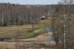
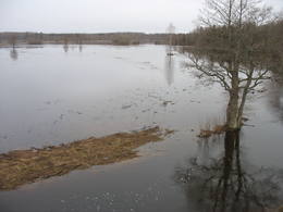
Klostri (Kloostri) skatu tornisMetāla tornis Kazari upes kreisajā krastā, ~ 5 km attālumā no Matsalu līča. No torņa redzamās Kazari deltas palieņu pļavas atrodas tikai 0,3 – 1 m augstumā virs jūras līmeņa, tādēļ pavasara palos un stipru vētru (īpaši rietumvēju) laikā ūdens appludina milzīgu teritoriju. Uzskata, ka platības ziņā šīs ir vienas no lielākajām Eiropas palieņu pļavām, kas ir nozīmīga dažādu tārtiņveidīgo putnu sugu ligzdošanas, dzērvju un zosveidīgo putnu atpūtas un barošanās vieta. Ir pagājis laiks, kad zemnieki Matsalu pļavās ganīja govis un pļāva sienu, tādēļ šobrīd pļavu apsaimniekošanu veic nacionālā parka administrācija. |
 |
Igaunija
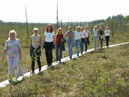
Viru purva taka (Viru raba matkarada)3,5 kilometrus gara taka, kas Viru purvu šķērso dienvidu – ziemeļu virzienā. Takas sākums ir jāmeklē pie Vahastu – Loksas (Loksa) ceļa. Viru purvā ir uzcelts koka skatu tornis, no kura atklājas tipiska sūnu (augstā) purva ainava ar nelielu ezeriņu, lāmu un akaču kopu. Taka nav lokveida, tādēļ ir jāpadomā par šī maršruta veikšanas loģistiku! Tās apskatei būs nepieciešama ~ 1h. Jāpiebilst, ka šī ir viena no interesantākajām nacionālā parka takām! 56
Pakalpojumi
56km - Attālums no valsts galvaspilsētas |
 |
Igaunija
Perajerva meža taka (Pärajärve metsarada)Četrus kilometrus gara marķēta lokveida taka, kas ved pa lielāku meža masīvu, iepazīstina ne tikai ar augiem un dzīvniekiem, bet arī mežsaimniecības tradīcijām. Takas sākums atrodas pie nelielā Perejerves ciema, uz kuru paveras labs skats no tuvējā paugura. Pie autostāvlaukuma izveidota atpūtas un piknika vieta. |
 |
Igaunija
Vilsandi sala (Vilsandi saar)Vilsandi nacionālā parka „sirds” un divpadsmitā lielākā Igaunijas sala (garums - 6 km, platums – 2 km). Tā ir ļoti „jauna” sala, kas sākusi veidoties pirms ~ 2000 gadiem zemes garozas celšanās rezultātā, savienojoties divām salām, kas noticis pirms ~ 350 gadiem. Cilvēki salu sāka apdzīvot 18. gs. un to galvenā nodarbe bija zvejniecība, kuģu būve, nelielā apjomā – lauksaimniecība. Līdz 2. pasaules karam te bija ap 200 iedzīvotāju, kuri vēlāk salu bija spiesti pamest PRSR pierobežas režīma zonas dēļ. Nozīmīgu Vilsandi daļu aizņem mežs un kadiķu lauki. To visā garumā šķērso grantēts - zemes ceļš ar atzariem uz jūras krastu. Salu ar kājām var izstaigāt vairāku stundu laikā, iepazīstot vietējo apbūvi (daļa arī mūsdienās celtas ēkas) un Tolli sētu, kur pēc nostāstiem dzīvojis nīderlandiešu jūras braucējs Johans Dolls, kā arī vējdzirnavas. Noteikti ir jāaiziet līdz salas rietumu krastam, kur atrodas Vilsandi bāka un bākas uzrauga saimniecības ēkas. No šejienes ir labi redzamas Vaikas salas. Šodien uz salas pastāvīgi (visa gada garumā) dzīvo tikai trīs cilvēki. |
 |
Igaunija
Mēkonnu skatu tornis (Mäekonnu vaatetorn)Viens no diviem nacionālā parka skatu torņiem, kas atrodas ~ 1,5 km ziemeļos no Ehijerva ezera (Ähijärv). Tornis ir veiksmīgi „nomaskēts” nelielā priežu pudurī, tādēļ tas „nebojā” izcilo dabas un kultūrainavu, kas paveras no tā skatu platformas. Pie autostāvlaukuma ir izveidota labiekārtota atpūtas vieta. |
|
|
Igaunija
Otepää augstieneViena no trijām Dienvidigaunijas augstienēm ar ainaviskiem pauguriem un skaistām skatu vietām. Tās „centrā” iegūlis līčiem bagātais Pühajärv ezers (tulkojumā – Svētezers). 230
Pakalpojumi
230km - Attālums no valsts galvaspilsētas |
 |
Igaunija
Eldas klints (Elda pank) un pussalaNacionālā parka dienvidrietumdaļā jūrā iestiepjas Eldas pussala – skaists un ļoti omaļš ar kadiķu mežu (alvāriem) noaudzis zemes pleķītis ar interesantu jūras krastu, kur atsedzas silūra perioda nogulumieži. No pussalas gala, kurā slejas vecs Padomju armijas robežsargu tornis (apmeklējumam bīstams!), paveras visaptverošs skats uz Vilsandi salu (atpazīstama pēc bākas), Lonalaidas salu (Loonalaid) – otru lielāko Vilsandi arhipelāgā, Salavu (Salava) un citām mazākām saliņām. Dabas mīļotāji var uzmeklēt Eldas klinti (Elda pank) – ~ 2 m augstu un 0,4 km garu atsegumu, kura piekājē var atrast interesantas ūdens izskalotas fosilijas. 261
Pakalpojumi
261km - Attālums no valsts galvaspilsētas |
 |
Igaunija
Otepē dabas parksAtrodas Otepē augstienes R daļā. Viens no izciliem piemēriem, kā aizsargājamas dabas teritorijas vērtības un reljefs tiek izmantots rekreācijas, sporta un aktīvās atpūtas vajadzībām, jo parkā ir izveidota šim mērķim atbilstoša un kvalitatīva infrastruktūra.
PakalpojumiPakalpojumi - atpūta
Apvidus slēpošanaSlēpošana 63 km garajā Tartu maratona trasē, kas šķērso parku. 
VelomaršrutsVelo maršruts apkārt Pühajärv ezeram no Otepē centra (~ 20 km), Otepää – Kääriku (11 km).
Dabas takaPārgājiens apkārt Pühajärv ezeram (12 km), Kekkose pārgājienu maršruts (14 km), Murrumetsa pārgājienu taka (3,5 km). 
Dabas vērošanaSkatu torņi Harimägi, Kuutsemägi kalnos, pie Otepē tramplīna un skati no Väike Munamägi un Otepē pilskalna. Informācija: www.otepaaloodus.ee. |
|
|
Igaunija
Hiiumaa salaOtra lielākā Igaunijas sala ar plašiem mežu masīviem, smilšainām un akmeņainām pludmalēm un vienu no Eiropas vecākajām bākām. 132
Pakalpojumi
132km - Attālums no valsts galvaspilsētas |
 |
Igaunija
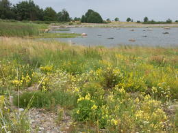
LuitemāTulkojumā no Igauņu valodas Luitemaa nozīmē „Kāpu zeme”. Piekrastes teritorija 13 km garumā starp Vöiste un Häädemeeste ar seklūdeņiem, plašām piejūras pļavām, Igaunijas augstāko kāpu masīvu un Tolkuses purvu (Tolkuse raba). Nozīmīga putnu vieta.
|
|
|
Igaunija
Otepää pilskalnsĻoti izteikta un cilvēka apdarināta reljefa forma ar plašu skatu uz apkaimi. Tā virsotnē atrodas 1224. g. bīskapa Hermaņa celtās pils drupas. Izrakumos atrasts pasaulē vecākais šaujamierocis. 225
Pakalpojumi
225km - Attālums no valsts galvaspilsētas |
 |
Igaunija
Ērdi taka (Öördi rada)1,2 km gara taka, kas pa purvainu mežu aizved līdz Ērdi purvam (Öördi raba) un tā austrumu daļā esošajam Ērdi ezeram (Öördi järv), pie kura izveidota atpūtas un peldvieta. |
 |
Igaunija
Hānjas dabas parksVeidots Hānjas (Haanja) augstienes ainavas un kultūrvides aizsardzībai. Tās centrālajā daļā atrodas Baltijas augstākais reljefa punkts – Lielais Munameģis (Suur Munamägi) – 318 m.vjl. un otrs augstākais – Vellamegi (Vällamägi) kalns – 304 m.vjl. Parka R daļā meklējama Reuges senleja (Rõuge ürgorg) - 7,5 km gara un līdz 60 m dziļa ledāja veidota ieleja, kurā iegūluši 7 ezeri, t.sk. Igaunijas dziļākais (38 m) – Reuges Lielezers (Rõuge Suurjärv).
PakalpojumiPakalpojumi - atpūta
VelomaršrutsRõuge – Nursi – Tindi – Rõuge (15 km) velomaršruts.
Dabas takaBaltijā visaugstāk izveidotā – Vällamäe dabas taka (2,2 km), Hinni kanjona laipu taka un Reuges senlejas pārgājienu maršruts (10 km), Kavadi ezera (Kavadi järv) pārgājienu taka (4,5 km).
Dabas vērošanaSkatu torņi Lielajā Munameģī un Reuges Lielezera A krastā. Informācija: www.haanjapark.ee. |
 |
Igaunija
Mēnikunno purvsAugstā purva masīvs ar vairākiem purva ezeriņiem, kura DA daļā izveidota laipu taka.
|
 |
Igaunija
Oksas (Oksa) takaBijušā piecstāvīgā metāla skatu torņa apkaimē plešas Lemmjegi upes palieņu pļavas. Netālu atrodas kādreizējā Oksas kroga (Oksa kõrts) vieta, kur saglabājies iespaidīgs manteļskurstenis. Apkaimes apskatei izveidota 0,8 km gara koka laipu taka. 175
Pakalpojumi
175km - Attālums no valsts galvaspilsētas |
|
|
Igaunija
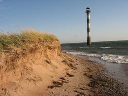
Tahkuna ragsTālākais Hiiumaa salas ziemeļu punkts. Igaunijas augstākā čuguna bāka (1873. – 1875. g.) un piemineklis kuģa „Estonia” bojā gājušo piemiņai. 175
Pakalpojumi
175km - Attālums no valsts galvaspilsētas |
 |
Igaunija
Leti tornis (Läti torn)Jēsū – Kepu ceļa malā pie Leti (Läti) ciema ir izveidots autostāvlaukums ar putnu vērošanas torni, no kura paveras skats uz Hallistes upes palieņu pļavām un tuvējā ciema apkārtni. Stipru palu laikā arī no šī torņa redzamā apkārtne (izņemot ceļus) var atrasties zem ūdens. Laba putnu vērošanas vieta. Läti tulkojumā no igauņu valodas nozīmē Latvija. |
 |
Igaunija
Saulas Zilie avotiPiritas upes kreisajā krastā izveidojušies trīs avotu ezeriņi ar daudzām izverdošām avotu „acīm” – katrs savā krāsā (zilganzaļā, baltā un tumšā), veidojot dažādas krāsu kombinācijas. Nereti saukti par Igaunijas skaistākajiem avotiem. Kopējais no tiem izplūstošā ūdens daudzums ir 20 – 30 l/s. Saglabājušies nostāsti par avotu dziednieciskajām (īpaši – acīm) īpašībām. Apkārtne labiekārtota.
|
 |
Igaunija
Nemmeveski ūdenskritums (Nõmmeveski juga)No vairākiem parka ūdenskritumiem noteikti ir jāapmeklē divi. 1,2 m augstais vienpakāpes Nemmeveski ir izveidojies uz Valgejegi upes (Valgejõgi), vietā kur tā šķērso Ziemeļigaunijas glintu. Šeit Valgejegi atgādina krāčainu (īpaši – pavasaros) kalnu upi, kas plūst pa vairākus metrus augstu klinšu ieskautu kanjonu. Palu laikā šo upes posmu ir iecienījuši ekstrēmie ūdenssporta veidu cienītāji. Pie ūdenskrituma un tālāk pa upi lejup redzamas ap 1920. g. celtās hidroelektrostacijas konstrukciju paliekas. |
 |
Igaunija
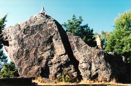
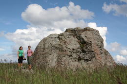
Jāņa - Toma akmens (Jaani - Tooma kivi)Neticami! Tā saka tie, kuri Ziemeļigaunijas dižāko akmeņu apzināšanu ir sākuši ar šo ledāja atnesto gigantu! Jāņa – Toma akmens kopā ar vēl diviem milžiem - Tammispeas akmeni (Tammispea kivi) un Ehalkivi (atrodas netālu no Kundas) pretendē uz Baltijas augstāko dižakmeņu (augstums sasniedz gandrīz 8 m) godu! Kaut arī pēc tilpuma (274 m3) tas ierindojas tikai Igaunijas lielāko akmeņu saraksta 14. vietā, arī pārējie izmēri (garums: 13,9, platums – 7,3 m, apkārtmērs – 35 m) ir gana iespaidīgi. Jāņa – Toma akmens ir meklējams Kasispeas (Kasispea) ciemā, neliela kadiķu lauka malā. 72
Pakalpojumi
72km - Attālums no valsts galvaspilsētas |
 |
Igaunija
Aegnas salaViscaur mežiem klāta sala Somu līcī ~ 14 km Z no Tallinas. Salu caurauž nelielu ceļu un taku tīkls. Ieteicams pārgājiens apkārt mainīgajai (kāpas, smilšaini, akmeņaini un ar niedrēm apauguši krasta posmi) salas piekrastei (~ 9 km). Kuģītis atiet no Piritas ostas.
|
 |
Igaunija
Perispeas pussala (Pärispea poolsaar)Perispeas pussalas piekrastē ir izvietojušies gan bijušie zvejniekciemi, gan Padomju armijas kara bāzu atliekas. Viena no pussalas savdabībām ir arī grandiozie ledāja atnestie dižakmeņi: nezinātājam ne visai viegli atrodamais un grūti pieejamais (jūrā) Odakivi, Purekari raga (Purekkari neem) galā starp citiem akmeņiem guļošais Purekari akmens (Purekkari rändrahn), jūras apskalotie Mehu akmeņi (Mähu kivid), Vīnistu (Viinistu) ciema krastmalā guļošais Melnais akmens (Must kivi), pāri niedru galotnēm savu „virsotni” izslējušais Kuhjakivi, visnotaļ iespaidīgais Painuva kivi, līdz kuram var nokļūt tikai peldus un savā ziņā nepārspējamais Jaani – Tooma suurkivi. Četri no pieminētajiem akmeņiem ir sasnieguši vai pat pārsniedz piecu metru augstumu! Akmeņiem bagāts ir Turbunēmes (Turbuneeme) ciems. Būs nepieciešams patiess entuziasms un laiks, lai visus uzskaitītos milžus atrastu un iemūžinātu savā fotokolekcijā. Perispeas pussala beidzas ar tālāko Igaunijas sauszemes ziemeļu punktu – Purekari ragu, kas ir ļoti ainaviska vieta. 74
Pakalpojumi
74km - Attālums no valsts galvaspilsētas |


