
Dabas objekti Igaunijā

Ar ko ievērojama daba Igaunijā?
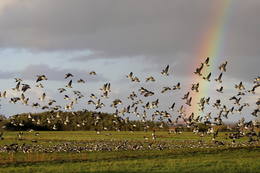
Iespaidīgākā Baltijas klinšu siena – t.s. Ziemeļigaunijas glints, „Līču zeme” – Lahemā ar nacionālo parku, „Salu zeme” – Sāremā sala un Monzunda salu arhipelāgs, Matsalu līcis kā viena no nozīmīgākajām masveida putnu atpūtas vietām migrāciju laikā, viens no izcilākajiem Eiropas meteorīta krāteriem, izcilākie Baltijas dižakmeņi un ūdenskritumi, Munameģis – Baltijas augstākā virsotne, Peipuss – piektais lielākais Eiropas ezers – ar senām zivju ieguves tradīcijām un ārkārtīgi lielā dabas daudzveidība, kas ir acīmredzami mainīga gan austrumu – rietumu, gan ziemeļu – dienvidu virzienā, ir tikai dažas no Igaunijas valsts dabas pievilcībām.
Lai uzzinātu vairāk par apmeklējamām teritorijām aicinām izmantot vides vai vietējo gidu pakalpojumus. Esiet saudzīgi pret dabu ceļojuma laikā - ievērojiet Zaļos padomus!
| Pārskats | Detaļas |
|---|---|
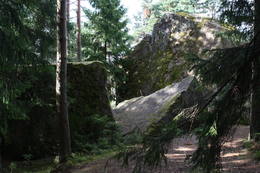 |
Igaunija
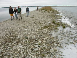
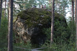
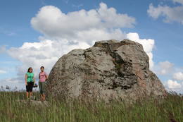
Tammispeas akmens (Tammispea kivi)Tikpat iespaidīgs, taču ne tik populārs tūrisma objekts kā netālu esošais Jāņa – Toma akmens. Tammispeas akmens iegūlis mežā, tāda paša nosaukuma nelielā ciemā, kas atrodas Eru līča (Eru laht) dienvidu krastā. Tilpuma ziņā (262 m3) – 16. lielākais Igaunijas dižakmens. Tā garums ir 10,7 m, platums – 6,5 m, augstums – 7,5 m, bet apkārtmērs – 27,8 m. Iespaidīgas ir arī šī akmens atlūzas. Ar šī akmens attēlu noteikti ir jāpapildina sava lielāko Baltijas dižakmeņu fotokolekcija.  70 70
Pakalpojumi
70km - Attālums no valsts galvaspilsētas |
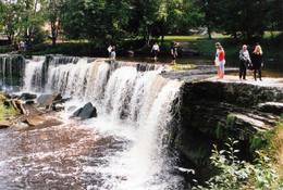 |
Igaunija
Keilas ūdenskritumsViens no Igaunijas ainaviskākajiem ūdenskritumiem – līdz 6 m augsts un līdz 50 m plats. Straujā Keilas upe aiz ūdenskrituma izveidojusi klinšainu kanjonu un tecējumu ar lielu kritumu, tādēļ pa Keilas parku vērts aiziet līdz ~ 1 km attālajam Somu līča krastam un atgriezties gar upes otru krastu.
|
 |
Igaunija
Eldas klints (Elda pank) un pussalaNacionālā parka dienvidrietumdaļā jūrā iestiepjas Eldas pussala – skaists un ļoti omaļš ar kadiķu mežu (alvāriem) noaudzis zemes pleķītis ar interesantu jūras krastu, kur atsedzas silūra perioda nogulumieži. No pussalas gala, kurā slejas vecs Padomju armijas robežsargu tornis (apmeklējumam bīstams!), paveras visaptverošs skats uz Vilsandi salu (atpazīstama pēc bākas), Lonalaidas salu (Loonalaid) – otru lielāko Vilsandi arhipelāgā, Salavu (Salava) un citām mazākām saliņām. Dabas mīļotāji var uzmeklēt Eldas klinti (Elda pank) – ~ 2 m augstu un 0,4 km garu atsegumu, kura piekājē var atrast interesantas ūdens izskalotas fosilijas. 261
Pakalpojumi
261km - Attālums no valsts galvaspilsētas |
 |
Igaunija
Mūgas Kabelikivi akmensPēc tilpuma (728 m3) - otrs lielākais Baltijas dižakmens. Baltijā vienīgais akmens ar šādu formas un izmēra apvienojumu. Tā augstums ir 7 m, garums – 19 m, platums – 11 m, bet apkārtmērs – 58 m. Kabelikivi atgādina līdz pusei zemē ieraktu milzu klints gabalu. Ledājs to „atnesis” no Somijas D daļas. Pēc sastāva - rapakivi granīts. Tam blakus atrodas vēl 2 visnotaļ iespaidīgi dižakmeņi.
|
 |
Igaunija
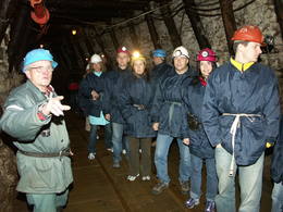
Degslāneklis jeb degakmensDegslānekli – Igaunijas enerģētikas un ķīmiskās rūpniecības galveno izejvielu mūsdienās iegūst atklātos karjeros vai pazemes šahtās. Šis nogulumiezis sācis veidoties Ordovika periodā (pirms ~ 450 - 480 mlj. g.) no tā laika augu un dzīvnieku atliekām. Kohtla – Nõmme piepilsētā vienā no izstrādātajām šahtām gida pavadībā var aplūkot gan šo nogulumiezi (Baltijas valstīs atradnes tikai Igaunijā), gan arī iepazīt tā ieguves veidus un vēsturi.
PakalpojumiPakalpojumi - atpūta
Dabas vērošanaSavukārt, Kivieli (Kiviõli) ciemā var uzkāpt Vecajā degakmens izdedžu kalnā (Vana tuhamägi), no kura paveras viena no savdabīgākajām Igaunijas ainavām. Informācija: www.kivioli.ee |
 |
Igaunija
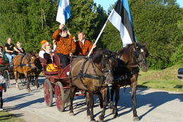
Tihuses zirgu sētas senkultūras takaPiedāvā izmitināšanu un organizētus pasākumus ar zirgiem. Netālu no mājām sākas apzīmēta senkultūras taka, kas aizvedīs līdz tiem laikiem, kad cilvēka dvēsele bija cieši saistīta ar dabas spēkiem. Pa ceļam var iepazīties ar dažādām seno laiku tradīcijām un ieražām. Par vietām, kas ir saistītas ar Muhu salas senkultūru, pastāstīs uz tējas nama sienām izliktā fotoizstāde. 148
 1-12 1-12
Pakalpojumi
148km - Attālums no valsts galvaspilsētas
1-12 Aktīvie sezonas mēneši |
 |
Igaunija
Nemmeveski ūdenskritums (Nõmmeveski juga)No vairākiem parka ūdenskritumiem noteikti ir jāapmeklē divi. 1,2 m augstais vienpakāpes Nemmeveski ir izveidojies uz Valgejegi upes (Valgejõgi), vietā kur tā šķērso Ziemeļigaunijas glintu. Šeit Valgejegi atgādina krāčainu (īpaši – pavasaros) kalnu upi, kas plūst pa vairākus metrus augstu klinšu ieskautu kanjonu. Palu laikā šo upes posmu ir iecienījuši ekstrēmie ūdenssporta veidu cienītāji. Pie ūdenskrituma un tālāk pa upi lejup redzamas ap 1920. g. celtās hidroelektrostacijas konstrukciju paliekas. |
 |
Igaunija
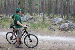
Kesmu pussala (Käsmu poolsaar)Ar skujkoku mežiem klāta pussala – piemērota vieta kājāmiešanai un braucieniem ar divriteni. Te izveidots velomaršruts, kas no Kesmu ciema (Käsmu küla) aizved līdz Kesmu ezeram (Käsmu järv) un tālāk gar pussalas rietumu uz ziemeļu piekrasti aizlokas atpakaļ līdz minētajam ciemam. Tas gan nav domāts iesācējiem, jo vietām ceļi ir smilšaini, bet krasta ceļš var būt aizgāzts ar kritušiem kokiem. Kesmu pussalas ziemeļu daļā atrodas izcilais Kesmu akmeņu lauks (Käsmu kivikülv). Lielākais no akmeņiem ir Matsikivi akmens (tilpums -132,9 m3). Ziemeļos no Kesmu ciema jūras krastā uzmeklējams iespaidīgu akmeņu „bariņš” Iespaidīgākais no tiem ir Vecā Jura akmens (Vana Jüri kivi), kura augstums ir 5,5 m, bet tilpums - 102,9 m3. Piemērotos laika apstākļos (g.k. vasarās) pa akmeņainu strēli var aiziet vai aizbrist līdz ~ puskilometru attālajai Sārtnēmes (Saartneem) saliņai. Atpakaļceļā uz ciemu var atstāt savu akmeni „Laimes akmeņu kaudzē”. Kesmu ziemeļdaļas apskatei izveidots 4,5 km garš kājnieku tūrisma maršruts. Kesmu kapteiņu ciemā (Käsmu kapteniküla) 1804. g. nodibināja pirmo Igaunijas jūrskolu un laikā no 1798. – 1920. g. uzbūvēja > 40 kuģus. Atrodamas ziņas, ka no nedaudz vairāk par 100 no šeit kādreiz dzīvojošajām ģimenēm ir nākuši 62 kapteiņi. Bijušā jūrskolas ēkā izveidots Jūrniecības muzejs. Netālu apskatāma Kesmu kapela. 81
Pakalpojumi
81km - Attālums no valsts galvaspilsētas |
 |
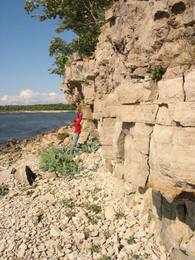
Igaunija
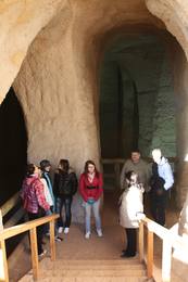
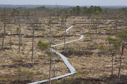
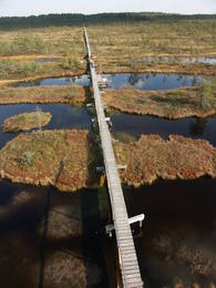
Piusas upes senleja un Piusas alas~ 15 km garš Piusas senlejas posms starp Vana - Vastseliina un Ignasõ ciemiem, kur upei novērojams liels kritums, ātras straujteces un skaisti Devona perioda smilšakmens atsegumi, no kuriem Hermas siena (Härma müür) ir augstākais (ar senlejas nogāzi – 43 m) smilšakmens atsegums Igaunijā. Piusas ciemā atrodas Piusas raktuvju alas. Tikai pavisam neliela daļa no > 10 km garās Piusas raktuvju sistēmas ir eksponētas un labiekārtotas kā apskates objekts.
PakalpojumiPakalpojumi - atpūta
Izbraukumi ar kuģīti/laivuIzbraukums ar laivu pa Vana - Vastseliina - Ignasõ (1 diena, ekstrēms, tikai palu laikā). Informācija: www.piusa.ee. 
Dabas takaPārgājiens gar upi visā senlejas garumā (~ 20 km). |
 |
Igaunija
Mejekoses pārgājienu taka (Meiekose matkarada)~ 3 – 5 km gara taka, kas ved pa veco ceļu gar Tēramā upes (Tõramaa jõgi) kreiso krastu. Takas malās izvietoti interaktīvi elementi bērniem, kas palīdz labāk uztvert dabā notiekošo. Taku ieskauj mitrie meži un palieņu pļavas, kas palu laikā atrodas zem ūdens. Tēramā (Tõramaa) ciemā apkārtnē atrastas cilvēka darbības pēdas jau no akmens laikmeta. 149
Pakalpojumi
149km - Attālums no valsts galvaspilsētas |
 |
Igaunija
Ērdi taka (Öördi rada)1,2 km gara taka, kas pa purvainu mežu aizved līdz Ērdi purvam (Öördi raba) un tā austrumu daļā esošajam Ērdi ezeram (Öördi järv), pie kura izveidota atpūtas un peldvieta. |
 |
Igaunija
Vilsandi nacionālais parksVeidots Vilsandi salu arhipelāga (~ 100 mazas saliņas) aizsardzībai. Lielākā no salām – Vilsandi ir 6 km gara un līdz 2 km plata. Līdz Vilsandi var nokļūt ar savu vai īrētu laivu, kā arī piemērotos apstākļos ar kājām, - veicot neparastu ~ 5 km garu pārgājienu pa jūru un mazām saliņām no Kuusnõmme pussalas Z gala.
Pakalpojumi
255km - Attālums no valsts galvaspilsētasPakalpojumi - atpūta
Izbraukumi ar kuģīti/laivuBrauciens ar jūras laivu vai jūras kajaku pa arhipelāga salām (Vaikas salas un Nootamaa sala ir dabas rezervāti un to apmeklējums ir aizliegts!);
Dabas takaPārgājienu maršruts Loona – Kuusnõmme (8 km), pārgājiens pa Vilsandi salu (~ 12 – 15 km), pārgājiens pa Harilaid pussalu (~ 10 km);
Dabas vērošanaPutnu vērošana Vaikas salās (Vaika saared) no Vilsandi R krasta (Vaikas salu apmeklējums aizliegts!); Skatu tornis Kuusnõmme pussalas Z galā. Apmeklētāju centrs atrodas Lonas muižā (Loona mõis). |
 |
Igaunija
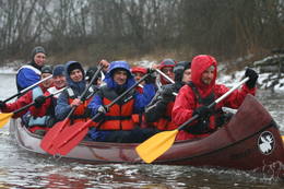
Piedzīvojumi 360°Uzņēmums nodarbojas ar dabas tūrisma pasākumu organizēšanu: vasarā laivošana ar kajakiem jūrā, rudenī – pārgājieni ar sniega kurpēm pa purvu, ziemā – pārgājieni ar sniega kurpēm, un pavasarī – laivošana ar kanoe laivām pa upēm. Dabas draugiem piedāvā tematiskas ekskursijas: pavasarī – lāču vērošanas safari un putnu vērošana, rudenī – aļņiem, roņiem un vilkiem veltīti tematiskie pasākumi. 37
1-12
Pakalpojumi
37km - Attālums no valsts galvaspilsētas
1-12 Aktīvie sezonas mēneši |
 |
Igaunija
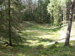
Ilumetsas meteorīta krāteriTrīs krāteri, no kuriem lielākā – Elles kapa (Põrguhaud) diametrs ir ~ 80 m, dziļums līdz 12 m. To ietver vairākus metrus augsti vaļņi. Pārējie krāteri ir dabā grūti atrodami un atpazīstami. Krāteru vecums ir ~ 6000 gadi. Līdz šim gan nav atrastas meteorīta atliekas, kas apstiprinātu to izcelsmi.
PakalpojumiPakalpojumi - atpūta
Dabas taka0,7 km gara taka līdz Põrguhaud krāterim. Informācija: http://www.ut.ee/BGGM/vaatamis/ilumetsa.html. |
 |
Igaunija
NaisāreMežiem klāta sala (6. lielākā Igaunijas sala) Somu līcī 14 km Z no Tallinas. Vēl pirms divām desmitgadēm – slēgtā zona, jo Padomju laikā te atradās ļoti slepena jūras mīnu ražotne.
|
 |
Igaunija
Hjupasāres pārgājienu taka (Hüpassaare matkarada)Iepazīstina ar Somā nacionālā parka lielākā purva – Kureso (Kuresoo) ziemeļaustrumu daļu, kur redzamas purva ezeriņu un lāmu ainavas. Takas sākumā atrodas igauņu komponista, ērģelnieka un folkloras vācēja Marta Sāra (Mart Saar) (1882. – 1963.) dzimtās mājas. To apkaimē pļavas apsaimnieko aitas. Lokveida takas garums ir 4,2 km. 169
Pakalpojumi
169km - Attālums no valsts galvaspilsētas |
 |
Igaunija
Abruka11. lielākā Igaunijas sala. Tās vidusdaļu aizņem > 100 gadus vecs platlapju (liepu, ozolu, ošu u.c. lapu koku) mežs, bet piekrastē dominē pļavas un nelieli mitrāji. Apdzīvota ir tikai Abrukas Z daļa. Tūristu maz apmeklēta vieta, kur iespējams nodoties mazskartas dabas baudīšanai.
PakalpojumiPakalpojumi - atpūta
Dabas takaPārgājiens cauri salai un gar tās ZA piekrasti (7 km). Informācija: www.abruka.ee.
Dabas vērošana |
 |
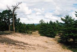
Igaunija
Tolkuse purvsCauri purvam un augstākajam Igaunijas kāpu masīvam izveidota izziņas taka. Skatu tornis ar skatu līdz pat Kihnu salai. 175
Pakalpojumi
175km - Attālums no valsts galvaspilsētas |
 |
Igaunija
KasariPiektā lielākā Igaunijas sala. Dabas takas, putnu vērošanas tornis, Kassari kapela (18. gs.) un Sääre tirp oļu strēle, pa kuru var doties 3 km garā pārgājienā. Ar Hījumā to savieno divi dambji, pa kuriem uzbūvēts autoceļš. Pakalpojumi
150km - Attālums no valsts galvaspilsētasPakalpojumi - atpūta
VelomaršrutsKäina – Orjaku – Kassari – Esiküla – Käina (22 km);
Dabas takaOrjaku dabas izziņas taka (līdz 2 km), Sääre tirp – gājiens pa 3 km garu akmeņainu zemes strēli Kasari D daļā
Dabas vērošanaKeinas (Käina) līcī (jūraskraukļu kolonija, ūdensputni u.c.) un pārējā salas piekrastē; Orjaku putnu vērošanas tornis, skatu platforma pie Vemlas līča (Vaemla laht). |
 |
Igaunija
Tēramā taka (Tõramaa matkarada)Divarpus kilometrus gara taka (vienā virzienā) aizved līdz Hallistes palieņu pļavām, kur Hallistes upes labajā krastā ir uzcelts divstāvīgs koka skatu tornis. No tā paveras visaptverošs skats uz atjaunotajām (izcirsti krūmi) Hallistes palieņu pļavām. Pavasara palu laikā no torņa redzamā apkārtne un tornis atrodas ūdenī. |
 |
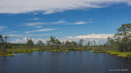
Igaunija
Ehijervs (Ähijärv)Karulas nacionālā parka lielākais ezers - 2,8 km garš, līdz 1 km plats. Ezera ziemeļaustrumu krastā atrodas parka apmeklētāju centrs. 5,5 m dziļais ezers ir gan zivīm, gan nostāstiem bagāta vieta. Ezera un tuvākās apkārtnes iepazīšanas nolūkā ir izveidota 3,5 km garā Ehijerva taka (Ähijärve teerada). Tās sākums atrodas pie iepriekš minētā apmeklētāju centra, kur izveidota atpūtas vieta un atraktīvs bērnu spēļu laukums. Taka sākumā ved gar ezera krastu, nelieliem mitrājiem un meža ceļiem, kas izmantoti iepriekšējos gadsimtos. |
 |
Igaunija
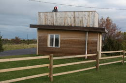
Skatu platforma Puises ciemāPuises „centrā” uz vienstāvu koka mājiņas jumta izveidota skatu platforma. No tās paveras laba ainava uz ciemu, ostu un piekrastes kadiķu laukiem. 121
Pakalpojumi
121km - Attālums no valsts galvaspilsētas |
 |
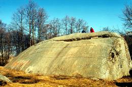
Igaunija
Majakivi akmens (Majakivi)Izmēru ziņā (584 m3, ~7 m augsts, apkārtmērs pie zemes – 32 m) Majakivi ir trešais lielākais Baltijas dižakmens. Tā tulkojums no igauņu valodas - „Mājas akmens” uzskatāmi pamato akmens izmērus. Majakivi ir iegūlis pārpurvotā mežā, kur to slēpj biezā koku lapotne. Akmens apskati ir jāapvieno ar pārgājienu pa Pikanõmme – Majakivi taku (4,5 km gara). Tās sākums ir meklējams Āblas purva (Aabla raba) rietumu malā, kur augstas ar priežu mežu apaugušas kāpas galā ir uzcelts skatu tornis ar lielisku sūnu purva ainavu. Pāri purvam un mitrākās vietās ir izveidotas laipas. Takas otrs „gals” meklējams pie Lēsi – Virves (Leesi – Virve) ceļa malas. 60
Pakalpojumi
60km - Attālums no valsts galvaspilsētas |
 |
Igaunija
Ignatsi pārgājienu taka (Ignatsi matkarada)Taka iesākumā ved pa mežu ieskautu bijušo šaursliežu dzelzceļa līniju, pa kuru pagājušā gadsimta vidū izveda kokmateriālus. Tās tālākā daļa izmet nelielu loku pa Suistna purvu (Suistna raba), kur uzcelts skatu tornis ar izcilu sūnu purva ainavu ar nelieliem ezeriņiem. Takas garums vienā virzienā ir 4,5 km. |
 |
Igaunija
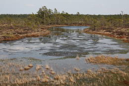
Matsalu nacionālais parksViena no iecienītākajām Igaunijas putnu vērošanas vietām, kur pavasara un rudens migrāciju laikā ir novērojama liela sugu daudzveidība un zosveidīgo putnu bari, kas atpūšas un barojas Matsalu līča un Kazari (Kasari) upes palieņu pļavās un seklajos piekrastes ūdeņos.
Pakalpojumi
1-12 Aktīvie sezonas mēnešiPakalpojumi - atpūta
Izbraukumi ar kuģīti/laivuOrganizēti braucieni pa Matsalu līci un Kazari upi
Dabas takaKiideva – Puise pārgājienu taka (5 km), Penijõe taka (3 km), Salevere izziņas taka (1,5 km)
Dabas vērošanaPutnu vērošana- visā parkā, īpaši – piekrastē, palieņu pļavās, tīrumos; Putnu vērošanas torņi vai platformas meklējamas: Puise, Kiideva, Haeska, Rannajõe, Kasari jõgi, Penijõe, Suitsu, Keemu. Apmeklētāju centrs atrodas Matsalu ciemā. Informācija: www.matsalu.ee |
|
|
Igaunija
Haeskas putnu vērošanas tornis (Haeska linnutorn)Pamatīgs trīsstāvu koka tornis, no kura atklājas viens no labākajiem Matsalu līča un tā apkaimes palieņu pļavu skatiem, kuras apsaimnieko mājlopi, veidodami piemērotu vidi dažādām putnu un augu sugām. Laba migrējošo zosveidīgo putnu vērošanas vieta. Tā kā tornis ietilpst Tūlingu (Tuulingu) saimniecības teritorijā – spēkrats ir jāatstāj netālu esošajā autostāvlaukumā, bet suņi jāved piesieti kakla siksnā. |
 |
Igaunija
Endlas rezervātsEndlas rezervāts veidots Endlas (Endla) purvu masīva un tā apkārtnes mitrāju aizsardzībai. Uzmanību! Lai apmeklētu Endlas rezervātu, ir jāreģistrējas rezervāta administrācijā un apmeklētāju centrā - Tooma ciemā.
|
 |
Igaunija
Perispeas pussala (Pärispea poolsaar)Perispeas pussalas piekrastē ir izvietojušies gan bijušie zvejniekciemi, gan Padomju armijas kara bāzu atliekas. Viena no pussalas savdabībām ir arī grandiozie ledāja atnestie dižakmeņi: nezinātājam ne visai viegli atrodamais un grūti pieejamais (jūrā) Odakivi, Purekari raga (Purekkari neem) galā starp citiem akmeņiem guļošais Purekari akmens (Purekkari rändrahn), jūras apskalotie Mehu akmeņi (Mähu kivid), Vīnistu (Viinistu) ciema krastmalā guļošais Melnais akmens (Must kivi), pāri niedru galotnēm savu „virsotni” izslējušais Kuhjakivi, visnotaļ iespaidīgais Painuva kivi, līdz kuram var nokļūt tikai peldus un savā ziņā nepārspējamais Jaani – Tooma suurkivi. Četri no pieminētajiem akmeņiem ir sasnieguši vai pat pārsniedz piecu metru augstumu! Akmeņiem bagāts ir Turbunēmes (Turbuneeme) ciems. Būs nepieciešams patiess entuziasms un laiks, lai visus uzskaitītos milžus atrastu un iemūžinātu savā fotokolekcijā. Perispeas pussala beidzas ar tālāko Igaunijas sauszemes ziemeļu punktu – Purekari ragu, kas ir ļoti ainaviska vieta. 74
Pakalpojumi
74km - Attālums no valsts galvaspilsētas |
 |
Igaunija
Putnu vērošanas tornis Puises ragāPuises ragā (Puise nina) ir uzcelts divstāvīgs atpūtas nams, kas apvienots ar putnu vērošanas torni. No tā paveras skats uz piekrasti, kas ir iecienīta migrējošo zosu atpūtas vieta. Šī ir privāta teritorija, kuras apskati vēlams saskaņot ar īpašnieku. 123
Pakalpojumi
123km - Attālums no valsts galvaspilsētas |
 |
Igaunija
Meža večas ģimenes parks (Metsamoori Perepark)Meža večas ģimenes parks izveidojies starp Kaikas kupolveidīgajiem pauguriem, un sastāv no vairākām viensētām, kas piedāvā uzzināt par dabai tuvu, veselīgu dzīvesveidu un tautas medicīnu. Katrai viensētai ir sagatavota sava programma, kur apmeklētāji var iepazīties ar ārstniecības augiem, ārstēšanu ar dēlēm, bišu un sēņu noslēpumaino pasauli, izjust buramvārdu un meditāciju vietu ietekmi uz sevi. Te māca gatavot ēdienus no nezālēm, cept maizi un taisīt garšaugu maisījumus. Ar viensētām var iepazīties arī individuālie apmeklētāji. 275
5-9
Pakalpojumi
275km - Attālums no valsts galvaspilsētas
5-9 Aktīvie sezonas mēneši |


