
| Nr | Nosaukums | Apraksts |
|---|---|---|
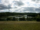 |
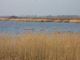
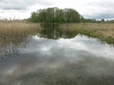
Ilziņš jeb Vestienas dzirnavezers pazīstams ar nostāstiem par tajā "periodiski uzpeldošām kūdras salām". Saskaņā ar vietējo iedzīvotāju sniegtajām ziņām, minētā parādība gan sen jau vairs nav novērota. Tajā pat laikā ezers un tā apkārtne ir nozīmīga daudzu aizsargājamu biotopu un sugu dzīves vieta. Ezers ietilpst Vestienas aizsargājamo ainavu apvidū. Ezeru var redzēt, braucot pa Ērgļu - Gaiziņkalna ceļu. Var pakāpties arī blakus esošajā paugurā (ziemeļos no minētā ceļa un ezera), no kura paveras plašāka skatu perspektīva.
|
|
 |
Kaļķupes ieleja veidojusies, Pilsupei (veidojas satekot Kaļķupei un Mazupei) šķērsojot Šlīteres Zilo kalnu turpinājumu dienvidos no Vīdales un Kaļķiem. Tā rezultātā izveidojusies izteikta upes ieleja ar ļoti sazarotu gravu un sānu gravu tīklu, kur vietām redzami Devona perioda smilšakmens atsegumi. Viena no teritorijas izteiksmīgākajām reljefa formām ir Puiškalns (Kaļķupes un Mazupes satekas vietā) – pilskalns un sena svētvieta, kas pazīstams kā iecienīts Talsu rajona tūrisma objekts. Nogāžu meži, dažādi pļavu tipi un bagātīgais augu sugu klāsts ir vēl viena šejienes dabas vērtība. Dabas lieguma teritorija ietver arī no Pilsupes ziemeļos esošo Šlīteres Zilo kalnu nogāzi, Lorumupes gravu sistēmu u.c. gravas.
|
|
|
|
Atrodas Liepājā, E. Tisē un Lauku ielas krustojuma galā. Pa Ezera laipu (Liepājas ezera palieņu pļavas) var nokļūt līdz putnu vērošanas tornim, no kura labi pārlūkojama ezera ziemeļdaļa. Laba putnu vērošanas vieta. Ietilpst Liepājas ezera dabas lieguma teritorijā. |
|
 |
Vidzemes augstienes centrālajā daļā esošā Jumurdas ezera, tā trīs salu ar platlapju mežiem un ainavas aizsardzības nolūkos veidots dabas liegums. Lieguma teritorija labi pārskatāma no Jumurdas muižas puses un no lieguma dienvidos esošo pauguru augstākajām daļām.
|
|
 |
Ne – biologam šī teritorija nebūs saistoša – grūti pieejams, atrodams un vēl grūtāk caurbrienams purvainu mežu masīvs Ziemeļos no Rīvas ciema. Nav domāts un piemērots apmeklējumiem. |
|
 |
Kaļķainais zāļu purvs izveidojies periodiski aplūstošā starpkāpu ieplakā, kas ir nozīmīga daudzu aizsargājamu augu sugu dzīvotne. Zāļu purvs ir dažviet pārskatāms no mežainajām kāpām, kas purvam pieguļ no dienvidaustrumu puses. |
|
 |
Teritorija veidota izteiktās Baltijas ledus ezera senkrasta kāples aizsardzībai, kuras izteiktākais posms stiepjas līdztekus Grobiņas – Ventspils šosejai vairāk nekā 10 kilometru garumā (ceļa austrumu pusē). Kaut arī no senkrasta augšpuses paveras plašs skats uz Piejūras zemienes ainavu, diemžēl, šobrīd nav izveidota neviena labiekārtota skatu vieta, kā arī atbilstoša informācija. Teritorijā sastopamas aizsargājamas augu sugas un biotopi. |
|
 |
Relatīvi grūti pieejama un cilvēka mazskarta teritorija kūdrā izstrādātajā Cenas tīreļa ziemeļaustrumu daļā, kur saglabājušies augstā purva biotopi ar purva ezeriem, kas kopumā veido nozīmīgu vietu ligzdojošām un migrējošām zosveidīgo, tārtiņveidīgo u.c. putnu sugām. Teritorija nav piemērota (un nav vēlams) tūrisma aktivitātēm.
|
|
 |
Vieta, kur var nodoties īsākām un garākām pastaigām. Te izveidota 1,6 km garā Sprīdīša taka (ar Annas Brigaderes pasaku varoņu koka skulptūrām), 3,8 km garā Meža ainavu mācību taka un 8 km (vienā virzienā) garā Augšzemes ainavu taka. Takas atrodas ledāja veidotā subglaciālā iegultnē, kur viens aiz otra izvietojušies vairāki ar caurtekām savienoti ezeriņi un purvi. Ainavas un citu vērtību aizsardzības nolūkā izveidots dabas liegums. Taku sākumā (netālu no Pilskalnes) ir apskatāms ap 30 m augstais Melnaiskalns (Rāmavas pilskalns).
|
|
 |
Ar mežu klāta teritorija, kas veidota reliktas aizsargājamas augu sugas - parastās īves u.c. augu aizsardzībai. Teritorija nav piemērota apmeklējumiem, jo apmeklētājs bez vides zināšanām šeit ieraudzīs „parastu” mežu.
|
|
 |
Lietuvas pierobežā atrodas Latvijai samērā unikāla teritorija – gāršas tipa mežs, kurā aug ozoli (daudz dižozolu), liepas, oši (ošu meži Latvijā – retums) u.c. lapukoki. Vietējā gida – mežziņa pavadībā var izstaigāt nelielu gāršas nogabalu, iepazīt raksturīgākos gāršas apdzīvotājus un to nozīmi dabas ritumā. Dabas liegums veidots mežu biotopu, augu un dzīvnieku sugu aizsardzībai, starp kurām sastopamas daudzas dienvidu reģioniem raksturīgās sugas. |
|
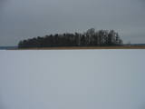 |
Lielā Baltezera sešas salas – Auzu, Priežu, Mazā, Liepu, Ropažu un Meldru sala izceļas ar lielu augu sugu un platlapju, melnalkšņu, priežu mežu daudzveidību. Teritorija labi pārskatāma no Ādažu luterāņu baznīcas puses, vai arī braucot ar laivu pa ezeru. Lielais Baltezers ir iecienīta makšķerēšanas (ziemā – zemledus) vieta.
|
|
 |
Viena no nedaudzajām Latvijas vietām (ap kilometru ziemeļrietumos no Lapmežciema), kur savulaik bijušas skaistas kadiķu pļavas. Kopš šajā vietā vairs nenotiek saimnieciskā darbība (pļaušana, lopu ganīšana) kadiķu pļavas aizaug un daudzi kadiķi jau ir aizgājuši bojā. Lai šo teritoriju turpmāk saglabātu tāda, kāda tā ir bijusi, tai nepieciešama regulāra apsaimniekošanas pasākumu īstenošana. Netālu no Kadiķu noras atrodas Slīteres nacionālais parks, tajā esošā Zilo kalnu krauja un Šlīteres bāka. No Lapmežciema puses 2009. g. septembrī bija uz ceļa sagāzti koki, ceļš pārrakts un uz tā izbērtas naglas, tādēļ šo objektu nav ieteicams apmeklēt!
|
|
 |
Sekls, eitroficēts lagūnas tipa (senā Litorīnas jūras lagūna) ezers, kura aizaugums ir sasniedzis ~ 60 %. Dabas liegums veidots gan aizaugošā ezera, gan tās apkārtnes (mitras pļavas) biotopu un ligzdojošo putnu (ap 60 sugas) aizsardzībai. Ezera apskates nolūkos var izmantot dambju sistēmu tā dienvidu krastā. Populāra makšķerēšanas un putnu vērošanas vieta.
|
|
 |
Agrāk šajā vietā zvejnieki novietoja laivas un žāvēja tīklus, tādēļ teritorijai piemīt arī kultūrvēsturiska vērtība. Kāpas apskates nolūkos ir izveidota divstāvīga skatu platforma. Visskaistākās pelēkās kāpas ir jūlija otrajā pusē un augustā, kad zied mazais mārsils un čemurainā mauraga, un pelēkā kāpa iekrāsojas dzelteni violetos toņos. Dabas lieguma „Pāvilostas pelēkā kāpa” platība ir 42 ha un tas izveidots, lai aizsargātu platāko kāpu Latvijā (virzienā gar jūru 1,5 km, virzienā no jūras uz sauszemi 812 m) un tajā atrodošos biotopus un sugas. Vienotu unikālu dabas kompleksu un neatkārtojamu skarbu ainavu tā veido kopā ar jūru, pilsētiņas vēsturisko zvejniekmāju apbūvi un ar liegumam pieguļošajiem arī aizsargājamiem biotopiem: priežu mežu, embrionālām kāpām, priekškāpām un reti kur sastopamo mitro pludmali ar avotiem. Jaunākā NATURA 2000 teritorija Latvijā. Atrodas Pāvilostas dabas liegumā. |
|
 |
Viens no dažiem Latvijas dzidrūdens ezeriem. Apskatāms no Lubānas - Ļaudonas ceļa malas pie Visagala. Lai saudzētu šo ezeru, tajā esošos aizsargājamos biotopus un sugas, ūdenstilpē nevajadzētu peldēties lielām cilvēku masām un pieļaut cilvēka darbības produktu nonākšanu ezerā.
|
|
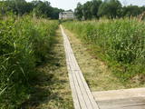 |
Pie Lielauces muižas sākas laipu taka, kas pa purvaino (pārejas tipa purvs) Lielauces ezera krastu aizved līdz laivu novietnei pie ezera atklātās daļas. Var nomāt laivu un makšķerēt, jo zivju krājumi tiek regulāri atjaunoti. Atrodas Vīķu purva dabas liegumā. |
|
 |
Dabas liegums veidots ezera, tā salu, ainavas, augu, putnu un sikspārņu aizsardzībai. Liegumu var apskatīt "no malas" - no ceļa, kas iet gar tā ziemeļu un ziemeļaustrumu robežu.
|
|
 |
Liegums veidots Austrumkursas augstienes Lielauces pauguraines ainaviskās daļas aizsardzībai, kurā ietilpst Zebrus un Svētes ezeri. Zebrus ezera ziemeļaustrumu krastā paceļas Ezerlūķu pilskalns. Savukārt, ezera austrumu krastā atrodas laivu bāze, skatu tornis, pieejama informācija par ezera izmantošanas iespējām. Teritorijā atrodas aizsargājami biotopi – avotu purvi, purvaini meži, aizsargājamas putnu un sikspārņu sugas. |
|
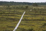 |
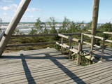
Tornis atrodas Vasenieku purva rietumdaļā, kuras apskates nolūkā izveidota interesanta un ar informatīviem stendiem un laipām labiekārtota dabas taka. No torņa vērojamas ļoti savdabīgas purva ainavas (pārskatāms viss purvs). Mitrā laikā noderēs piemēroti apavi! |
|


