
| No | Name | Description |
|---|---|---|
|
|
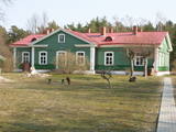
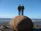
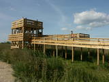
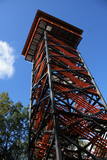
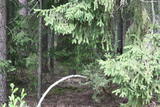
Atrodas Liepājā, E. Tisē un Lauku ielas krustojuma galā. Pa Ezera laipu (Liepājas ezera palieņu pļavas) var nokļūt līdz putnu vērošanas tornim, no kura labi pārlūkojama ezera ziemeļdaļa. Laba putnu vērošanas vieta. Ietilpst Liepājas ezera dabas lieguma teritorijā. |
|
 |
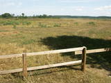
This is about 30 km long territory between the Baltic Sea and the Kolka-Ventspils road. It begins at the mouth of the Irbe River and ends at Ovišrags. The territory was mostly established so as to protect dry coniferous forests, grey dunes, damp areas among the dunes, other landscape features and plants and animals in the area. Distinctive landform - kangari and vigas - and grey dunes are Europe-wide significant habitat. Tourists love the sandy and quiet beaches of the area, as well as the Miķeļbāka and Ovīši lighthouses (it is possible to visit Oviši lighthouse and museum in it) and the Lutheran Church at Miķeltornis. There are also certain leftover elements of the Soviet military system, former narrow gauge railway (railway embankment, former train stations marked by memorial stones etc.) which unfortunately are not used as tourism resources. |
|
 |
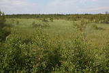
Periodically flooded flood-land meadows on the eastern and southern shores of Lake Burtnieks are an important nesting location for the rarely seen corncrake. A nature and information trail has been established at Vīsrags with directions, information stands and a viewing tower.
|
|
 |
This is another so-called hill left behind by the Ice Age – five kilometres long with a height of between 15 and 30 metres and with high hillocks and steep hillsides. Te most distinct part of the hill can be found between Lake Pinti and Lake Šeški. The pine forests on the hillocks are a habitat with many rare and protected species. A trail has been established to tour Grebļa Hill, as well as Āža Hill and Kausu Hill, but it is recommended that visitors travel the trail in the company of a guide. The biological diversity of the area is made clear if one knows, for instance, that more than 500 kinds of butterflies have been found in the restricted territory.
|
|
 |
This is a segment of the Gauja River which is full of rapids in some places. It stretches from Vidaga and the place where the Vecpalsa River flows into the Gauja. Along the Gauja and its tributaries, dolomite outcrops can be seen on the shores, and the largest of these are the Randati cliffs. The restricted area was established mostly to protect various kinds of forests, meadows, outcrops and their habitats. This is an interesting part of the central section of the Gauja for people who enjoy beautiful landscapes and for those who are water tourists.
|
|
 |
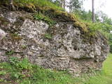
Covered with rocks and with small capes and inlets, this is the eastern shore of the Bay of Rīga and the only place in Latvia where sandstone outcrops are found. These are the result of the abrasive effects of waves between Tūja and Vitrupe. Among the most distinguished of these outcrops are the Veczemi cliffs, which are less than half a kilometre long and up to four metres high. The area has been improved for tourists. It has to be said that this part of the shoreline changes very often, particularly after large storms.
|
|
 |
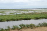
The trail tells about the protected nature area which is found in Riga city and has been established to protect the seashore habitats (forests, meadows, reeds, dunes) and the birds, populating the daugavgrīva meadows. There is a bird watching tower with facilities for people with special needs.
|
|
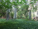 |
This is a fairly unique territory in Latvia – a vast forest of oak trees (many of them very large, indeed), linden trees, elms and various other deciduous trees. In the company of a forest guide, the visitor can walk through a small part of the forest, learning about the inhabitants of the area and their importance. This is an environmentally protected zone.
|
|
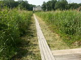 |
Near the Lielauce manor house start of a wooden pathway which crosses the transition-type swamp that is on the shore of Lake Lielauce to a boating facility near the open part of the lake. Boating and fishing are possible – here, too, the population of fish is regularly restored. The area is a part of the Vīķi swamp restricted zone. |
|
 |
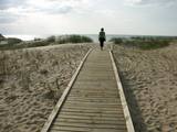
This is the only viewing platform in Latvia which is wheelchair-accessible. From the second level, you can see much of the restricted territory – areas of reeds, some wetlands, dunes and the estuary of the Daugava River. This is a good location for bird-watching.
|
|
 |
At the centre of this restricted area is the eutrophic Lake Tosmare, a former lagoon from the Littorina Sea. The lake and its surroundings offer protection to many plants and birds. At the southern end of the lake one can spot remnants of the former Liepāja fortification system, and to the West is one of the most important parts of that system – the Fortress canal. |
|
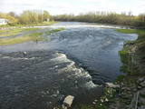 |
Above and below the town of Kuldīga, the Venta River is distinguished by a variety of biotopes – hillside forests, sandstone and dolomite cliffs, meadows, protected plants and animals, and diverse landscapes. There are popular tourism objects in this part of Kurzeme – the Venta dam, the stone bridge of Kuldīga, the Veckuldīga castle hill, etc. An ecological tourism trail runs along the banks of the Venta, and a bicycling trail has been installed on its left bank. |
|
 |
Dabas liegums atrodas dienvidaustrumos no Lubāna ezera un tas veidots purva un meža biotopu un tajos esošo sugu aizsardzībai. Gar teritorijas ziemeļu robežu iet Nagļu - Degumnieku ceļš (iekļaujas kopējā Lubāna dambju sistēmā), pa kuru apkārt Lubāna ezeram izveidots velomaršruts. Tas nozīmē, ka teritoriju var aplūkot arī "no malas", netraucējot tās dabiskās norises. Teritorija ietilpst arī Lubāna mitrāja kompleksā.
|
|
 |
Labi redzams no Kornetu centra. Līdz tornim var nokļūt pa taku, kas ved pāri pļavai uz uzlokas pa stāvā Dzērves kalna nogāzi. No torņa paveras viens no skaistākajiem Vidzemes un Latvijas skatiem. Redzams Dēliņkalns, blakus esošie Dzērves un Ievas ezeri, Hānjas augstiene un Lielais Munameģis (acīgākiem vērotājiem). |
|
 |
There is no need to enter the bog to see it, there are good views from the highway Ventspils – Riga (77 km, bus stop “Pagrieziens uz Elkskeni”). The main value of restricted area is chalky fen bog with brown bog-rush (greatest habitat finding in Latvia). Be careful when stopping on the highway – mind the traffic! A couple of kilometers towards Riga, on the right side of the highway, there is sign to Grizu Velna kresls ( Grizu Devil Chair) which is an attractive boulder (protected).
|
|
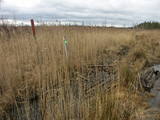 |
The part of the swamp which has mosses, not peat, is important for plover-type birds during nesting season, and goose-type birds during migration.
|
|
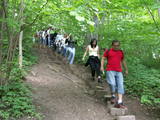 |
The Little Sigulda of Pilskalne is a place for longer or shorter hikes. Here you will find a number of trails – the Sprīdītis trail (1.6 km, featuring wooden sculptures of characters from fairy tales by Anna Brigadere), the Forest landscape educational trail (3.8 km), and the Highland landscape trail (8 km in each direction). The trails are in a sub-glacial depression with a number of little lakes and swamps that are connected by streams. This is a restricted environmental area aimed at protecting the landscape and its treasures. At the beginning of the trails (near Pilskalne) there is the Melnaiskalns (Rāmavas) castle hill, which is around 30 m high. |
|
 |
Territory is not attractive for a visitor without environmental knowledge and is very hard to find and reach through swampy forests on the North from Riva village. Area is not intended and appropriate for visits.
|
|
 |
One of the most beautiful areas along the Venta River and its tributary, the Šķērvelis River. The river valleys and gullies along them are quite deep, and dolomite and sandstone cliffs can be spotted here and there. There are also rapids on the river. The largest cliffs in Kurzeme – the Ātraiskalns and Gobdziņi cliffs – can be seen on the banks of the Venta. The Lēni Catholic Church is near the restricted area. There are no tourist elements in the restricted territory at this time. The Venta is a popular destination for water tourists, however, from Nīgrande to Kuldīga. |
|
 |
The Kaļķupe River valley was established as the Pilsupe River (formed by Kaļķupe River and Mazupe River) crossed the Blue hills of Šlītere to the South of Vīdale and Kaļķi. The distinct river valley has a branched network of gullies in which Devonian sandstone has been uncovered and can be seen in some locations. Puiškalns Hill (located at confluence of Kaļķupe River and Mazupe River), which was used as a castle hill and as a sacred location long in the past, is one of the most distinctive parts of the area. It is a popular tourist destination in the Talsi District. Hillside forests, various kinds of meadows and a wide range of plants are also of value in the local environment. |
|


