
| No | Name | Description |
|---|---|---|
|
|
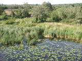
Atrodas Burtnieka ezera austrumu krastā – uz ezera poldera dambja. Pavasara un rudens migrāciju laikā – laba putnu vērošanas vieta. Putni redzami ne tikai ezera piekrastē, bet arī poldera mitrajās pļavās. |
|
 |
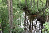
The lime gully that emerged as the Baltic ice lake receded is crossed by the powerful streams of Mežmuiža, and the water from these streams contains a high concentration of lime salts. The water from the streams flows into a mill pond that has a very interesting colour. The sculptor Teodors Zaļkalns once lived in the travertine mill that is alongside the pond. Wood pathways have been installed for those who wish to visit the streams.
|
|
 |
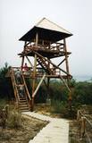
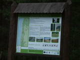
Periodically flooded flood-land meadows on the eastern and southern shores of Lake Burtnieks are an important nesting location for the rarely seen corncrake. A nature and information trail has been established at Vīsrags with directions, information stands and a viewing tower.
|
|
 |
This is another so-called hill left behind by the Ice Age – five kilometres long with a height of between 15 and 30 metres and with high hillocks and steep hillsides. Te most distinct part of the hill can be found between Lake Pinti and Lake Šeški. The pine forests on the hillocks are a habitat with many rare and protected species. A trail has been established to tour Grebļa Hill, as well as Āža Hill and Kausu Hill, but it is recommended that visitors travel the trail in the company of a guide. The biological diversity of the area is made clear if one knows, for instance, that more than 500 kinds of butterflies have been found in the restricted territory.
|
|
 |
The Lake Lubāns depressions which are alongside the lake’s western and south-western parts feature little-changed forests and swamps, where many rare and protected birds nest. Many uncommon and protected habitats are in the region.
|
|
 |
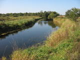
This territory is on both sides of the central section of the Raķupe River. On the banks of the river, there are many different meadow habitats, as well as massive oaks growing in the places of former farmsteads which are uninhabited by now. This is an important place for rare plants and animals. There is no tourism infrastructure for visitors in the area. Visitors who are especially interested in the environmental cognition are advised to visit the territory in attendance of experienced local guide. Raķupe is not usable for water tourism because of tilts of trees and beaver dams. |
|
 |
Along with the Nagļu ponds, these are Latvia’s largest fishing ponds. They were established on the flood-land peat areas of Lake Lubāns in the 1970s, when the hydrotechnical system of the lake was first established. The Lubāna-Gaigalava road bisects the Kvāpāni-Īdeņa ponds. There are three bird-watching towers on the dams of the ponds. The ponds are a major location for water bird nests, as well as places for migrating birds to rest. There are extensive bird-watching opportunities in the area.
|
|
 |
Palieņu un mitrās pļavas abos Dubnas upes krastos, kuras nelielā posmā var vērot no Rožupes - Vārkavas ceļa. Piemērotā laikā šeit dzirdēsiet griezes balsi, kas ir Eiropā izzūdoša putnu suga.
|
|
 |
This is one of the most impressive and extensive natural structures of its kind in Latvia in terms of appearance and landscape. The ice age left behind this wall-like terrain, which is up to 27 metres high and at the top of which the Rīga-Ērgļi road has been built. The Great Kangari hills offer a view of the Great Kangars lake and the Great Kangari swamps and ponds. The Ķoderi castle hill, also known as the “Big Man’s Bed” is found here. The restricted area was established to protect the structure and its related biotopes and plants.
|
|
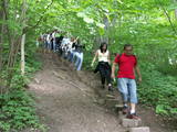 |
The Little Sigulda of Pilskalne is a place for longer or shorter hikes. Here you will find a number of trails – the Sprīdītis trail (1.6 km, featuring wooden sculptures of characters from fairy tales by Anna Brigadere), the Forest landscape educational trail (3.8 km), and the Highland landscape trail (8 km in each direction). The trails are in a sub-glacial depression with a number of little lakes and swamps that are connected by streams. This is a restricted environmental area aimed at protecting the landscape and its treasures. At the beginning of the trails (near Pilskalne) there is the Melnaiskalns (Rāmavas) castle hill, which is around 30 m high. |
|
 |
Salīdzinoši liela un cilvēka mazskarta teritorija ziemeļos no Lubāna ezera, kas izceļas ar lielu purvu un mitro mežu, kā arī tajā dzīvojošo organismu daudzveidību. Cauri teritorijas austrumu daļai tek Aiviekste. Dabas liegums ir grūti pieejams, tajā nav izveidota ar tūrismu saistīta infrastruktūra, tādēl vislabākais veids ir to aplūkot no Lubānas - Gaigalavas ceļa, kā arī putnu vērošanas torņa pie Gomeļa ezera (Gūmelis), kurš gan 2007. g. rudenī bija cietis no apmeklētāju vandālisma. Teritorija ietilpst Lubāna mitrāja kompleksā.
|
|
 |
A diverse stand of forest that is bisected by the Vidzeme highway and the Rīga-Lugaži railroad line. This is a place where the largest endangered bird in the world – the European roller – can be found. Between one-quarter and one-fifth of the Latvian population of the crow is found here. This, too, is one of the last nesting places for the green woodpecker.
|
|
 |
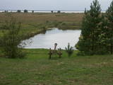
Dabas liegums veidots ezera, tā salu, ainavas, augu, putnu un sikspārņu aizsardzībai. Liegumu var apskatīt "no malas" - no ceļa, kas iet gar tā ziemeļu un ziemeļaustrumu robežu.
|
|
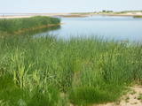 |
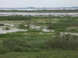
This area is full of coastline meadows, lagoons, muddy little lakes and sandy shallows, all full of reeds. This area of the eastern shore of the Bay of Rīga is found between Ainaži and Kuiviži. The Randa meadows are an enormously important location for water birds and rare plants – some 500 in all. A new bird-watching tower and a nature trail have been established for those who wish to study the meadows.
|
|
 |
This is a short stretch of the Daugava River valley between Lielvārde and Dzelme, with islands and shallows in the river, as well as with reeds and wet meadows alongside it. During migration season, many goose-type and plover-type birds rest and feed here. The location is also an important nesting area for several other kinds of birds.
|
|
 |
This territory protects the shore of the onetime Baltic lake of ice, which most significant part stretches for 10 kilometres on the eastern side of the Grobiņa-Ventspils highway from Kapsēde till Vērgale bus stop. From the top of this ancient shoreline there is a lovely view of the Piejūra lowlands, but no specific viewing areas or information stands have been installed. There are protected species and habitats in the territory. |
|
 |
Territory is not attractive for a visitor without environmental knowledge and is very hard to find and reach through swampy forests on the North from Riva village. Area is not intended and appropriate for visits.
|
|
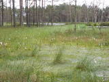 |
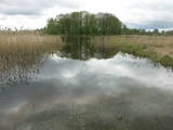
This is one of the largest areas of swampland in Latvia, lying between Lake Babīte and Olaine. Most of the area is still made up of peat. Relatively untouched is the northern part of the swamp, where there is a lovely set of swamp lakes, featuring landscapes of moss swamps. The heath is one of the few swamps in Latvia where the western-type and eastern-type swamp coexist. This is an important location for protected birds. A nature trail and viewing tower are to be installed at the heath in the near future.
|
|
 |
This territory covers the shoreline between the Ventspils-Liepāja highway and the Baltic Sea on both sides of the Užava River. The territory was established to protect shoreline biotopes such as the grey dunes, as well as a number of endangered plants. To the South of the mouth of the Užava River we find one of the most romantic lighthouses in Latvia – the Užava lighthouse, which is at the top of a steep dune. |
|
 |
This is a territory which regularly floods when the Lielupe River crosses its banks. These are flood-land meadows of importance to birds. The area can be surveyed from the Rīga-Liepāja highway and the Kalnciems road which runs along it. |
|


