
| No | Name | Description |
|---|---|---|
 |
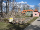
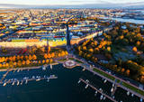
Kemeri (Kemmer) are mentioned in the literature sources for the first time in 1561. In the second half of the 18th century and in the beginning of the 19th century the curative properties of Kemeri sulphur spring waters and swamp mud are well known, therefore here representatives of the highest Kurzeme social circles arrive for treatment. The local foresters welcome the guests. During this time the first mud baths are organised. For some time the development of Jurmala and Kemeri beach is terminated by the Fatherland War of 1812. Two decades later – from 1833 until 1835 the benefits of Kemeri were enjoyed by General Governor of the Baltics Graf K. M. Palen, who addresses the Tsar of Russia Nicholas I for supporting further development of the health resort. Plead is supported and in 1836 Tsar allocates 700 ha of state land and grants 100 000 roubles for the construction of sanatorium and paving of the road from Kemeri till Sloka-Tukums high-way. Two years later (in 1938) the first state bath institution is opened. This is also considered the year of founding the health resort. In several stages the formation of Kemeri Landscape Park is begun, which is an important part of the health resort. In the middle and second half of the 19th century further development of the health resort is promoted by steamboat, as well as railroad traffic that are opened in 1877 from Riga till Tukums. In 1912 direct railroad line Kemeri-Moscow is opened. Early before World War I the number of patients reaches 8300 per year. The 1st battlefront of World War I is held in Kemeri swamp for several years and the health resort is significantly destroyed. Despite this fact after the war it develops rapidly and Kemeri becomes a beloved recreation place for the residents of Riga and one of the most modern health resorts in Europe. In 1924 a new bath institution with mud-baths is built in Kemeri, which at the time is one of the most modern in Europe, but in 1936 State President Kārlis Ulmanis opens one of the most prominent buildings of the first independent state of Latvia period – hotel "Ķemeri". Also after World War II – during the Soviet times the health resort is significantly expanded and almost 10 sanatoriums are established within its territory, in which about 100 doctors are employed. In 1971 Kemeri is awarded the status of All-Union health resort. From 1975 until 1985 the largest of sanatoriums is constructed in Kemeri – Līva (initially – Latvija), which has two blocks of eleven storeys. Up to 1200 patients at the same time could receive treatment at Līva, but within a year – up to 140 000 patients. The sanatorium is closed in the beginning of the 90ies of the 20th century as unprofitable. Up to 1994 five sanatoriums operate in Kemeri: "Čaika", "Daugava", "Dzimtene", "Ķemeri" and "Līva" (Latvija) and resort policlinic "Ķemeri". The latter period may be considered the declining fame period of Kemeri as a large-scale health resort. |
|
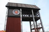 |
Tāpat kā Ventspils Rātslaukums, arī Tirgus laukums ir uzskatāms par pilsētas vēsturiskā centra nozīmīgu daļu, kura apkaimē ir saglabājies senais ielu plānojums. Kādreizējā Rātsnama vietā tagad slejas kariljonu zvana pulksteņu tornis. Tas zvana katru stundu, bet 12:33:44 un 00:33:44 ar īpašu melodiju ieskandina astronomisko Ventspils laiku. Tirgus laukumā ir aka, kas saulainā laikā darbojas arī kā Saules pulkstenis. Monētu automātā var izkalt īpašu piemiņas monētu. |
|
 |
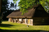
The Slutiški village is a very ethnographic village with a layout and buildings typical of the Latgale region, complete with decorated windows and facades. The Slutiški Old Believers House features a museum focusing on the cultural environment and traditions of the Old Believers. One of Latvia’s most unusual landscapes can be seen from the ancient banks of the Daugava River. |
|
 |
Old fishermen village, which was first mentioned in 1429. Before WW2 Juodkrante was popular resort in Europe and it still has its traditions nowadays. Village has an unique scenery with its wooden houses, promenade, Lutheran Church (1885), Lithuania's Art Museum Hall and much more. |
|
 |
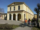
A small town on the way from Riga to Bauska. Town's name is first mentioned in written sources in 1492. Here you can see Lutheran Church and former Manor Park |
|
 |
Third biggest island in Estonia. Full of beautiful grown junipers, little dolomite outcrop on the coast of the sea and fishermen villages on the coastline. |
|
 |
Exploring of Sigulda can be started with a visit to Sigulda castle ruins. The construction of the castle was begun by the Knights of the Sword Order in 1207, but in 1236 it was rebuilt for the needs of the Livonian Order. Sigulda castle suffered much from the wars in the second half of the 16th century and in the beginning of 17th century. During the Northern War, it is burned down and is no more restored. Today south-western building of the convent and the tower of the main gate, behind which is the inner forefront of the castle with open air stage, which offers impressive views over the Gauja valley. Currently the reconstruction of castle ruins is in progress. Construction of New castle (owner - Prince Kropotkin) in the South of the Sigulda took place from the 1878 until 1881. From 1923 - 1940 the building was the Palace of Writers, but during the Soviet years - Cardiology sanatorium. Since 2003 Sigulda district council is located there. The manor complex includes wooden house (middle of 19th century), which was Kropotkin's family home, barn (turn of the 18th - 19th century), gardener's house (19th century) and a stone fencing (19th century.) If we make our way from New Castle in a north-eastern direction, after almost 2 km we will reach Vejupite ravine. There you can see the shallow (3.6 m) but high (6.1 m) in Peter's Cave and deep Pucu ravine with Krauklupite. At the conjunction of ravines of both streams rises a Satezele hill fort (plateau 90 x 75 m), where in the beginning of 13th century was the oak castle of Liv land chief (eldest) - Dabrelis. Near can be found Krauklu gorge - ravine of Vejupite left bank, with 11 m high sandstone walls and 5.2 m deep Krauklu cave. At the conjunction of Vejupite ravine and Gauja valley columns Paradise (Gleznotaju) Hill - a very picturesque place, painted and photographed since old times! The Paradise Hill can be reached with a electric vehicle. In the west part of Sigulda is located Ferris wheel (works during the summer) and Air cableway (streetcar) - the only this type of vehicle in Baltics (built in the 1969). Its self-supporting cable extends in 1060 m length and without any support joins the Gauja River valley banks between Sigulda and Krimulda ~ 40 m above Gauja River. Here you can enjoy excellent views! In the south-western part of Sigulda one can walk to mighty Beites precipice, which is split by the deep ravine of stream. On the west side of the ravine lies Keizarskats, which is located ~ 67 m above the Gauja level and offers good views of Krimulda and Turaida castle. Sight place was arranged here already in the 1862 when Russian Tsar Alexander II visited Sigulda. In the eastern part of the ravine wooden Keizarkrēsls (Emperor Stool) is located. |
|
|
|
Ein einzigartiges Örtchen beiderseits des Flusses Minija, wo der Fluss eine „Hauptstraße” ist. Litauens Venedig. |
|
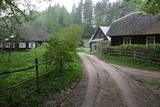 |
Liela meža masīva vidū gleznainās Būkas (Būka) upes krastos starp kokiem ieslēpies teiksmainais Vaišnoriškes ciems. Šis ir viens no skaistākajiem nacionālā parka etnogrāfiskajiem ciemiem. Vaišnoriške kā apdzīvota vieta sākusi veidoties 1756. g., kad šeit sena vēsturiska ceļa malā darbojies krogs. Pirmā viensēta ciematā ir zināma no 1830. g. Šodien redzamā apbūve ir tapusi g.k. 20. gs. sākumā. Ciems ir palicis cilvēku atmiņās ar liepu medu, jo meža velšu vākšana un biškopība bija viena no galvenajām šejieniešu nodarbēm. Tagad ciemā ir piecas sētas. No Vaišnoriškes var uzsākt laivu braucienu pa seklo un dzidro Būku. |
|
 |
Madonas centrālais laukums, kas vēl 20. gs. sākumā bija tirgus laukums. Pēc apjomīgās restaurācijas tas ir kļuvis par ievērības cienīgu pilsētvides objektu. Laukuma ziemeļu pusē atrodas pilsētas un novada pašvaldība un Madonas novada TIC. |
|
 |
For the first time Valmiera is mentioned in the historical sources in 1323. Until the 13th century this place was in the composition of Talava, inhabited by Latgalians. Construction of Valmiera medieval castle began in the beginning of the 13th century, but in 1283, between the Gauja River and Rate River towered church. Location near to the Tartu-Pskov and Novgorod trade routes greatly facilitated the economic development of the populated area. During the 14th-16th century Valmiera was a part of the Hanseatic League. It suffered greatly from wars, epidemics and fires in 16th to 18th century. In the second half of the 19th century the economic boom started again. It was also facilitated by the building of wooden bridge across the Gauja in 1866 and Riga-Pskov railway opened in 1899. Historic centre is destroyed in 1944. During post-war years, large industrial companies such as - Valmiera glass fiber factory (to this day) are opeating in the town. Today, Valmiera is economic, educational and sports centre of Vidzeme. |
|
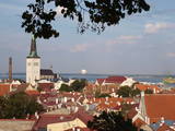 |
The capital of Estonia. The Old Town of Tallinn - excellent medieval (14.-15th century) building monument. The former city of Hanza. |
|
 |
Although out of 104 village houses 97 were destroyed during World War I, at the end of the 30ies of the 20th century Lapmezciems "recovered" fast, and one of the most powerful coastal fishermen cooperatives in Latvia were operating in it. During the Soviet times here one of the largest fishery collective farms – "Selga" was founded here, the blocks of which can be seen at the mouth of the Siliņupe River. Today Lapmezciems is a popular area for summer cottages, a recreation and bathing place. As an interesting history monument of fishery the sedum of Lapmezciems is available for viewing – it is the former wharf of fishing boats, where fishermen built nest cabins and stored their equipment. Between Pīlādži Street and the left bank of the Siliņupe River in the 3rd and 2nd millennium BC settlement of fishermen and hunters were located, where a memorial stone is erected. This is the most ancient known location populated by humans within the territory of Kemeri National Park. Part of the findings is displayed at Lapmezciems museum, where local history research exposition is formed and materials about Finnish Jeager fights within the territory of Klapkalnciems are gathered. |
|
 |
This is an urban construction monument that was created between the 17th and 19th century, and it is of national importance. The street layout around Jelgavas and Rātūža streets forms closed blocks of buildings. There are Lutheran, Catholic, Orthodox and Baptist churches in Jaunjelgava. One of the most outstanding architectural monuments is City Hall, which was built in 1912 and features Art Nouveau forms. None of the city’s five synagogues has survived. The historical centre of Jaunjelgava features a promenade that runs along the banks of the Daugava River. This is a popular place for strolls, leisure and swimming. |
|
 |
Helsinki is the capital of Finland and the biggest city in Finland. It offers a lot to see as it is seaside city surrounded by islands but city itself is full of wonderful parks. This city has everything to attract all kinds of people - from architecture and culture to nature and even has wide range of places where to enjoy night-time Helsinki. |
|
 |
Dagda is mentioned in the historical sources of 17th century as a trader village. In 1772, Dagda district was included the Pskov province, but in 1802 - Vitebsk province. In 1905 widespread peasant unrest took place here, during which many important architectural monuments were destroyed. Town was not spared also by the two world wars. What's to see for the tourist here? In the centre of Dagda historical buildings - houses, built of red brick - the so-called "Jewish tradesmen houses" are preserved. Dagda is the only place in the Latvia, where every year is celebrated Anne's Day in the town's park! |
|
 |
Until 13th century, Smiltene region was a part of Talava country, inhabited by Latgalians. After Crusaders invasion it was won by the Archbishop of Riga, and he built a stone castle on the steep river bank of Abuls in 1370. The following wars and epidemics did not spare the development of settlement, nor the people. Present shape of the town began to emerge in 19th century along with the vigorous activities of owner of Smiltene manor first Lieven. Until the World War I, wood working factory, hydroelectric power plant (established in 1901, first in the Baltics), and other companies were operating in Smiltene. In 1944 when the German forces retreated, much of the Smiltene historical buildings were destroyed in the fire. |
|
 |
Tukums in the historical sources is mentioned in 1253 agreement of the Livonian Order and the Bishop on the division of Kursa. If the town's name is translated from the Liv language, it means "a pile, mountains of sand". at the beginning of 14th century German merchants and craftsmen settlement was formed at the Livonian Order stone castle, whose flowering was facilitated by the proximity of Riga - Prussian road. Later the city was largely influenced by the construction of Riga - Tukums railway in1877. During the Soviet period the on the eastern outskirts of Tukums, the largest Soviet military airfield and military town in the Baltic States was deployed. Today Tukums is a district centre of the same name with a wide range of services offered to tourists. |
|
 |
Ļoti skaists un ainavisks etnogrāfiskais ciems Balošas (Baluošas) ezera ziemeļu krastā, netālu no diviem iepriekš minētajiem ciemiem. Te apskatāmas interesantas un skaistas koka ēkas, kas celtas no guļbaļķiem, ar niedru vai lubiņu jumtiem un izrotātas ar dažāda veida dekoratīvajiem elementiem. Pirmo reizi rakstos Šumini minēti 1784. g. Savu vārdu ciems ieguva no kādreiz dzīvojošas ģimenes uzvārda. Kā interesantākā ir jāpiemin sena klēts. |
|
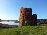 |
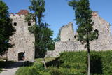
Piltene is one of the smallest and oldest cities in Latvia, first mentioned in 1295, and being granted the rights of a city in 1557. Between the 14th and 16th century, Piltene was the administrative centre for the Bishopric of Kurzeme. The historical streets that surround the castle ruins feature wooden buildings from the first half of the 19th century. The bishop’s castle in Piltene was built at the turn of the 14th century and used until the 16th century. Only its foundations and fragments of its tower on the banks of the Vecventa River survive. |
|
