
| Nr | Nosaukums | Apraksts |
|---|---|---|
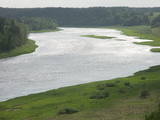 |
Dinaburgas taka sākotnēji metas lejā un tad pēc strauja kāpuma uzved stāvajā Daugavas krastā, kur gravu ieskauts paceļas ap 25 m augstais Naujenes (Vecpils) pilskalns - Daugavpils pilsētas " šūpulis". Saglabājušās pilsdrupas, pie kurām izveidots unikāls Dinaburgas pils brīvdabas makets. Objekts atrodas Augšzemes aizsargājamo ainavu apvidū un Daugavas loku dabas parkā.
|
|
 |
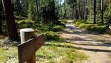
10 km garais pārgājienu maršruts iepazīstina ar vienu no vēl retajiem, cilvēka mazāk ietekmētajiem Daugavas senlejas posmiem. Tā sākums – Aizkraukle, finišs – Skrīveri. Gar upes krastu izvietotas atpūtas vietas. Maršrutu var braukt arī ar velosipēdu. |
|
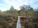 |
Iespēja šķērsot purvu sausām kājām, vienlaikus baudot mazskarto dabu. To var īstenot gan pa bijušā Smiltenes – Valmieras – Ainažu šaursliežu dzelzceļa dambi, kas 3- 4 km garumā šķērso purvu DA – ZR virzienā, gan arī izstaigājot labiekārtoto lokveida laipu taku, kas atrodas dambja A pusē. Dabas liegums. Atrodas Ziemeļvidzemes biosfēras rezervātā.
|
|
|
|
Atrodas Burtnieku ezera D krastā, kur plašā apkārtnē regulāri applūstošas palieņu pļavas - nozīmīgs griezes un citu putnuuzturēšanās un ligzdošanas vieta. Atrodas Burtnieku ezera pļavu dabas liegumā, Ziemeļvidzemes biosfēras rezervātā. Iepazīstina ar Burtnieku parku un Burtnieku muižas kungu māju. |
|
 |
Kokneses dabas taka (5,65 km) ved gar Daugavas un Pērses krastiem un savieno Kokneses parku un Likteņdārzu. Pastaigā pa dabas taku var doties no jebkuras sevis izvēlētas vietas, kas vijas cauri Kokneses parkam. Takā izveidotas laipas, tiltiņi, informācijas stendi un norādes. |
|
 |
Nītaures vēstures takā var apskatīt un iepazīt dažādus vēsturiskus objektus no 13.gadsimta līdz mūsdienām - seno pilskalnu, vācu ordeņa pilsdrupas, luterāņu un pareizticīgo baznīcas, soda vietu un muižas seno apbūvi. |
|
|
|
Kartavkalnā, kur senāk atradusies seno zemgaļu apmetne, ir izveidota dabas taka ar soliņiem, piknika vietām. Šeit apskatāms arī Jaunpils Kartavu kalns un lapegļu aleja, kā arī iespējams aplūkot, kāda izskatās senlatviešu apmetne ar īstu guļbaļķu sētu.
|
|
 |
Dabas takā gar Rojas upi iespējamas 3 dažāda garuma distances, kas lokveidā ved gar upi un tai pieguļošajiem mežiem – 2 km, 7 km un 15 km, kas katra atzīmēta ar savas krāsas norādēm. Dzeltenais aplis 2 km, zilais aplis – 7 km, sarkanais aplis – 15 km. Maršrutus var veikt arī ar velosipēdu, taču braucot ar velo, atsevišķi posmi var būt grūti izbraucami smilšu dēļ. Pie upes ierīkotas vairākas atpūtas vietas ar soliem, galdiem, labierīcībām, šūpolēm, vingrošanas konstrukcijām, atkritumu urnām, kā arī ugunskura un telšu vietām. Pie atpūtas vietām Žocenē un Rojā ir izveidotas arī laivu piestātnes. Takas sākumā upes krastā labiekārtota vieta, kur upē ietek Rojas avots, ko kā ūdensņemšanas vietu iecienījuši vietējie iedzīvotāji. |
|
 |
Folkloras taka "Jāņkalni" iepazīstina ar mūsu senču rakstiem, zīmēm un dievībām, kas ir mūsu folkloras mantojums. Folkloras takas (garums: apm. 1,5 km vai 2 stundas) mērķis ir arī iepazīstināšana ar senlatviešu ieražām, folkloru, kā arī tautu dainu izprašana. Piedāvā iziet Latvijas karti - labirintu ar 19 etnogrāfiskajiem novadiem. Gids Jums sniegs izsmeļošu stāstījumu un atbildes uz interesējošiem jautājumiem.
|
|
|
|
Nepilnus 3 km garā taka iepazīstina ar dziļo Imulas ieleju – Abavas kreisā krasta pieteku. Īpaši iespaidīga ieleja izskatās bezlapu periodā, kad ir apjaušami tās izmēri un formas. Viens no takas iespaidīgākajiem objektiem ir Buses jeb Matkules pilskalns. Apskatāmi citi objekti – Baznīckalns, Bedrīšakmens, Ķauķa kalns ar avotiņu. Atrodas dabas parkā „Abavas senleja”. |
|
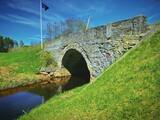 |
Takas sākums atrodas Vidagā, vietā, kur uz Vizlas celts vēsturiskais akmens arkas tilts. 1,2 km garā taka bez marķējuma ved gar pašu upes krastu līdz pat ietekai Gaujā. Redzami skaisti dolomīta atsegumi, nelieli krāčveidīgi ūdenskritumi un iespaidīgais Žākļu dižakmens. |
|
 |
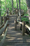
Ejot Saulrieta taku, mūs sagaida Saulkrastu jūrmalai raksturīgā ainava – plaša, smilšaina pludmale un priekškāpas, Pēterupe ar Saules tiltiņu un dižpriedes kāpu mežā. Takas posmā pie Inčupes grīvas aplūkojama Baltā kāpa – viena no Saulkrastu raksturīgākajām vietām. Tās baltais, 18 m augstais smilšu atsegums senatnē kalpojis kā orientieris vietējiem zvejniekiem. Lielās vētrās kāpa tikusi noskalota, to postījuši arī kāpas apmeklētāji, izbradājot stāvo nogāzi, tāpēc kāpas nostiprināšanai un aizsardzībai izveidoti pinumi. Kāpa apaugusi ar vecu priežu mežu. No kāpas paveras skaists skats uz jūru, Inčupes grīvu un plašo pludmali. Atgūt spēkus iespējams gan pie jūras, gan iekārtotajās atpūtas vietās. Lai saglabātu un nodrošinātu kāpas apskati, izveidota laipu taka ar skatu platformu. Takas garums ~ 3,6 km, apskatei nepieciešamais laiks – 1 – 2 h. Sniegotās ziemās Baltās kāpas apkārtnē ir izveidota distanču slēpošanas trase. |
|
 |
Augstrozes pilskalna taka atrodas ainaviskā vietā, gleznainā 13. gadsimta pilskalnā, kas apvīts ar teikām un leģendām. No pils drupām paveras labākais skats uz lielisko ainavu, ko veido Augstrozes Lielezers un Ziemeļu purvi.
|
|
