
| No | Name | Description |
|---|---|---|
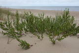 |
The territory is established in order to protect the dunes and the seashore habitats. There are beautiful beaches and wooded dunes, and the paved Klaipēda–Palanga bikeway trails through the park, which is worth travelling at full length. |
|
 |
Viens no iespaidīgākajiem nacionālā parka pilskalniem, kura piekājē atradusies senpilsēta. Arheoloģisko izrakumu gaitā te atrastas kuršu senlietas. Tiesa, mežs un biezais augājs traucē uztvert šī nozīmīgā arheoloģijas pieminekļa patiesos apjomus un formu. Uz pilskalnu vasarās ved izpļauta taka. Ja esat Žemaišu Kalvarijas pusē un atliek brīvs brīdis, tad savā maršrutā var iekļaut arī šo apskates objektu. |
|
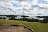 |
This park is located in the northern part of the Žemaitija Highlands, and much of it is taken up by Lake Plateliai. The park was established to protect lakes, rivers, wetlands and forest ecosystems, as well as the local cultural environment.
|
|
 |
The only school-based botanical garden in Lithuania was planted in 1989 at the Traupis school. More than 8,000 types of plants grow in the garden, and all of them have been collected by Sigutis Obelevičius. |
|
 |
1855, als einen Schiffahrtsweg getieft wurde, wurde im Haff unerwartet eine Bernsteinablagerung gefundet. In der Zeit zwischen 1860 und 1890 wurde dort 2250 Tonen Bernstein gewonnen, einbezogen einzigartige Bernsteingegenstände aus der Jungsteinzeit und der Bronsezeit. |
|
 |
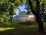
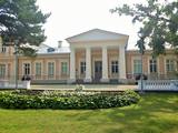
This park surrounds the mansion of the Biržuvenai Estate, and it is based on the terrain of the Virvite River and an old river that provides water for the park. The central part of the park is regularly designed, while the rest has elements of landscape. Opposite the estate is a glass sculpture, and on its western side is a wooden pergola. Local trees dominate in the park, but there are also trees from other countries. Of importance is a group of oak trees on the banks of the river, as is an alley of linden trees that leads to the pond in the direction of the estate. |
|
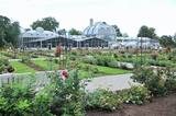 |
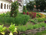
This botanical garden was opened in 1923 as a scholarly centre. The garden covers more than 60 hectares, and approximately 30 ha are open to the public. |
|
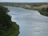 |
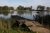
This lovely part of the Nemuna River between Alytus and Pakuonis meanders through cliffs that are up to 40 m high.
|
|
 |
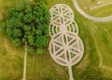
Located on an island in Lake Dviragio, the Salu Estate and its park, when viewed from above, are reminiscent of the boundaries of Lithuania. The park to the east of the estate is a mixed-type park and is one of the oldest ones in Lithuania. Back in the day, it was a forest park where trees were never cut down. The park featured maple, linden, elm, aspen and other local trees, and they are now around 200 years old. A winding path links the alley to a park trail by the lake. The various plants and fragments of alleys have survived to the present day. |
|
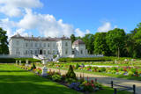 |
The Palanga Botanical Garden surrounds the Palanga Amber Museum and is one of Lithuania's most beautiful and well-kept parks. It is in the area of the St Birute Forest, and it is familiarly known as the Birute Park. The park covers 101.3 ha of land, and offers a wide variety of landscapes, carefully organised trails, flowerbeds, two ponds and small architectural elements. |
|
 |
Kauņas jūras reģionālais parks (Kauno marių regioninis parkas) dibināts 1992. gadā. Tas ietver Nemunas HES uzpludināto posmu – lielāko Lietuvas ūdenskrātuvi no Kauņas līdz Piļonas (Piliuona) ciemam. Viena no nozīmīgākajām parka vērtībām ir ainava, kas veidojusies ilgā cilvēka un dabas mijiedarbībā. Parkā konstatētas 950 augu sugas, 600 dzīvnieku, t.sk. - 34 zivju sugas. Parka nozīmīgas dabas vērtības ir meži, augstie purvi, kadiķu audze. Parkā ir apskatāmi dažādu vēsturisko periodu liecinieki – senču pilskalni, Pažaislis klosteris, Kauņas cietokšņa Piektais forts, kā arī Rumšišķes (Rumšiškės) brīvdabas muzejs – viens no lielākajiem (195 ha) šāda veida muzejiem Eiropā. Vaišvīdavā (Vaišvydava) ir izveidots parka apmeklētāju centrs, parkā ir dabas takas, piemēram, Žiegždriai ģeoloģiskā taka un Dubravos izziņas taka. |
|
 |
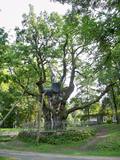
This is the thickest English oak (Quercus robur) in Lithuania, with a circumference of 9.4 m (as opposed to the Kaive oak in Latvia, which has a circumference of 10.18 m).
|
|
|
|
Veisieji reģionālais parks (Veisiejų regioninis parkas) veidots (1992.g.) Sudavas augstienes (Sūduvos aukštuma) ainavu, bioloģiskās daudzveidības un kultūras pieminekļu aizsardzībai. Viena no parka bagātībām ir ezeri, kuru iegarenās formas liecina par ledāja darbības rezultātu. Pēdējā apledojuma laikā šeit atradusies ledāja mala. Ezerus (kopā – 37) ieskauj lielāki meža masīvi uz kontinentālām (iekšzemes) kāpām, kas piemēroti atpūtai dabā, dabas vērošanai, ogošanai un sēņošanai. Parkā ir iekārtotas peldvietas, kur patīkami gremdēties vasaras tveicē, izveidotas dabas takas, bet mazās upītes, kas savieno ezerus, ir piemērotas braucieniem ar kanoe laivām. Veisieji reģionālā parka teritorijā ir liela augu un dzīvnieku daudzveidība. Šeit tiek aizsargātas arī tādas retas sugas kā Eiropas kokuvarde Hyla arborea (parka simbols), purva bruņurupucis Emys orbicularis, dažādas orhideju sugas u.c. |
|
 |
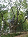
This park dates back to the mid-18th century and is to the south of Lake Stelmuže. There are winding trails on all sides of the hillock that lead to the Christ the King Church, with linden, maple, oak, birch, fir, elm and pine trees. At the foot of the hillock is the Laime stream, and visitors are welcome to stroll along the alley of oak trees. The oldest and fattest oak tree in Lithuania is one of the oldest ones in Europe. It is though that it is 1,500 to 2,000 ears old, and its record-setting diameter is 3.5 metres (eight or nine people linking hands are needed to encircle it). The tree is 23 m high. |
|
 |
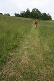
In the central part of the Žemaitija Highland, this park was established to protect local landscapes. Lithuania’s highest hillocks are found here – Mėdvegalis (235 m above sea level) and Šatrija (229 m). There are also other hillocks which offer a great view of the area – make up your own tour here.
|
|
 |
Dating back to the 19th century, this is a characteristic and beautiful park in Lithuania. There is no shortage of exotic trees in the park, including maples, lindens, elms, firs, oaks, etc. The pride of the park is Lithuania's fattest fir tree with a diameter of 1.2 m, as well as a linden tree with six branches that, over the course of time, have become vertical trunks on their own. Entry to the park is via a pergola that is covered with ivies. |
|
 |
This museum was established in 2014 in partnership with the Siauliai University botanical garden. The museum is 85 m long and 40 m wide on a territory that covers 0.34 ha. |
|
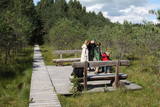 |
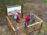
Varniku mežā (Varnikų miškas) ir izveidota patiesi interesanta dabas izziņas taka, kas iet cauri dažādiem biotopiem – skujkoku un ozolu mežiem, purvainu mežu un sūnu purvu ar akačiem un nelieliem purva ezeriņiem, kur uzceltas divas skatu platformas. Mitrajās vietās un purvā ir izveidotas koka laipas. Šī ir populāra pastaigu vieta. Taka ir lokveida un marķēta. Tās apskatei būs nepieciešama ~ pusotra stunda. |
|
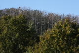 |
Aiz Jodkrantes (Nidas virziens) ceļa labajā pusē ir izveidots autostāvlaukums un labiekārtota vieta, no kuras apskatāma Lietuvas (atrodamas ziņas, ka arī Eiropas) lielākā zivju gārņu Ardea cinerea un jūras kraukļu Phalacrocorax carbo kolonija, kur kopā varētu būt ~ 3000 putnu. Neaizmirstiet līdzi paņemt tālskati! |
|
 |
This is Lithuania’s largest mossy swamp, and the Čepkeliu Nature Reserve was established to protect it. Before visiting the swamp, you must register at the Dzūkijos National Park’s visitor centre (Marcinkonys, Šilagėlių gatve 11). |
|


