
| No | Name | Description |
|---|---|---|
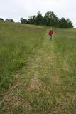 |
Viens no iespaidīgākajiem nacionālā parka pilskalniem, kura piekājē atradusies senpilsēta. Arheoloģisko izrakumu gaitā te atrastas kuršu senlietas. Tiesa, mežs un biezais augājs traucē uztvert šī nozīmīgā arheoloģijas pieminekļa patiesos apjomus un formu. Uz pilskalnu vasarās ved izpļauta taka. Ja esat Žemaišu Kalvarijas pusē un atliek brīvs brīdis, tad savā maršrutā var iekļaut arī šo apskates objektu. |
|
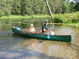 |
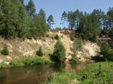
Ūla ir viena no skaistākajām un likumsakarīgi – arī populārākajām Lietuvas ūdenstūristu upēm. Tās galvenā pievilcība ir skaistā ainava ar augstajiem upes krastiem, kuros slejas iespaidīgas smilšu kraujas līdzīgi kā Irbes krastos Latvijā. Laivošanu var sākt no Mančagires (Mančiagirė) vai Zervinos ciemiem un turpināt līdz Ūlas ietekai Merķē un tālāk pa Merķi līdz pat Merķinei un Nemunai. Ūla nav plata, taču posmā no Zervinos ciema tajā nav neviena koku aizgāzuma vai cita šķēršļa, kuram laiva būtu jānes apkārt. Ašā straume, asie līkumi, dzidrais ūdens un tajā redzamā zemūdens pasaule rada patiesi patīkamu sajūtu! Upes krastos atrodas gan publiskas (apsaimnieko Lietuvas valsts meži), gan privātas ūdenstūristu apmetnes un atpūtas vietas. Šī ir vienīgā Baltijas upe, kur ūdenstūristiem ir jāpērk licence. Ūlas krastos atrodas divi interesanti apskates objekti – Ūlas atsegums (Ūlos atodanga) un spēcīgs avots – Ūlas acs (Ūlos akis). Savukārt, Merķe jau ir jau krietni platāka upe, taču ar acīm redzamu straumi un dažviet pat jaukām straujtecēm. Kaut arī Merķes krasti ir mazapdzīvoti, tajos atradīsim piemērotas nakšņošanas vietas. Pa Ūlu un Merķi no Zervinos līdz Merķinei sanāk „mierīgs” pusotras - divas dienas ilgs brauciens. |
|
 |
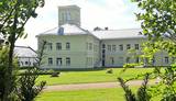
This mixed-type park dates back to the latter half of the 19th century and has remained all but unchanged. It is in a lovely place between two lakes, and its spatial structure was preserved when it was restored. The park covers 10 ha and has two parts. One is a fairly precisely rectangular territory alongside the state, surrounded by a stand of linden trees and introduced trees. The other part has a natural forest. The largest oak tree in the park has been declared to be a protected element of natural heritage. The mighty trunk of the tree is 6.3 m around, has a 2m diameter and stands 30.5 m high. |
|
 |
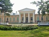
The Jakiškiu Estate was first mentioned in documents in the late 16th century. The estate had elements of Classicism in terms of its architecture. Among the buildings, the only ones that have survived are the mansion, an ice cellar and a steam-driven windmill. The estate has not been restored, so it is still authentic. Its artistic soul is preserved by various objects that remain from the time when people lived at the estate and from the Soviet era. Alongside the estate are a few fragments of a park, which covers approximately 2 ha. There is an ancient alley of linden trees that are on both sides of the entrance road, as well as several other valuable types of trees and a small pond. |
|
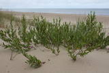 |
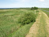
The territory is established in order to protect the dunes and the seashore habitats. There are beautiful beaches and wooded dunes, and the paved Klaipēda–Palanga bikeway trails through the park, which is worth travelling at full length. |
|
 |
Work on this arboretum began in 1958 at a local forest research station that is near the village of Vaišvidava. The arboretum collects and exhibits various local and imported plants for scholarly, educational and decorative purposes. The arboretum covers some 50 ha of land, with more than 800 types of plants. Some parts of the arboretum have rare and protected trees and bushes, and these can only be visited if you contact the arboretum in advance. |
|
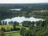 |
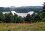
This territory is rich with forestland and lakes (some 285 in all). There are extensive opportunities for active recreation or calm leisure.
|
|
 |
This is Lithuania’s largest mossy swamp, and the Čepkeliu Nature Reserve was established to protect it. Before visiting the swamp, you must register at the Dzūkijos National Park’s visitor centre (Marcinkonys, Šilagėlių gatve 11). |
|
 |
Dating back to the 19th century, this is a characteristic and beautiful park in Lithuania. There is no shortage of exotic trees in the park, including maples, lindens, elms, firs, oaks, etc. The pride of the park is Lithuania's fattest fir tree with a diameter of 1.2 m, as well as a linden tree with six branches that, over the course of time, have become vertical trunks on their own. Entry to the park is via a pergola that is covered with ivies. |
|
 |
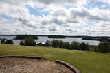
Vermutlich ein heidnischer Hügel. Schöner Blick auf die 6 Seenlandschaften. Ein Symbol vom Nationalpark. |
|
 |
This is one of the most outstanding areas in the entire Baltic States with active underground waterways which still, to this very day, dissolve local gypsum rock. Parts of the area collapse regularly, and there are legends about all of this. Underwater rivers, streams, the so-called Karvės (Cow) cave, etc., can be seen in the area.
|
|
 |
The Nemuna River divides up into two large streams at its estuary at Kuršių Marios, and this has established the Rusnė Island. This is a unique environmental territory with wetlands, streams, ancient rivers, lagoon lakes and flood plains which are important places for birds to nest and rest during migration season. Vast tracts of this territory are flooded each spring. The park includes the territory to the N and W of Rusne (lagoons, swamps, fishing ponds, Kuršių Marios).
|
|
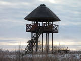 |
A island in the delta of Nemuna. Etnographical museum, Uostadvaris lighthouse, bird watching tower. |
|
 |
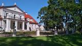
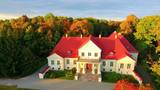
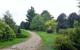
The Rietavas Park was once the largest landscape park in Lithuania. It was established between 1848 and 1855 in a naturally cleaned forest and reconstructed in 1904 and 1905. This is a very nice park with local bushes and trees, as well as several foreign plants. Various alleys of trees and fragments of the hedges have been preserved along with the white gate, the red gate and a guard's hut. The park has a complex system of bodies of water, including a few ponds, a curvy river and an island that is surrounded by the old river. |
|
 |
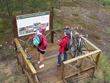
This territory is Lithuania’s most forested area, and people here have always lived in accordance with nature. Local treasures include berries, mushrooms, honey, clean water from streams and rivers, etc. People here have engaged in various crafts, as well as in beekeeping.
|
|
 |
Kauņas jūras reģionālais parks (Kauno marių regioninis parkas) dibināts 1992. gadā. Tas ietver Nemunas HES uzpludināto posmu – lielāko Lietuvas ūdenskrātuvi no Kauņas līdz Piļonas (Piliuona) ciemam. Viena no nozīmīgākajām parka vērtībām ir ainava, kas veidojusies ilgā cilvēka un dabas mijiedarbībā. Parkā konstatētas 950 augu sugas, 600 dzīvnieku, t.sk. - 34 zivju sugas. Parka nozīmīgas dabas vērtības ir meži, augstie purvi, kadiķu audze. Parkā ir apskatāmi dažādu vēsturisko periodu liecinieki – senču pilskalni, Pažaislis klosteris, Kauņas cietokšņa Piektais forts, kā arī Rumšišķes (Rumšiškės) brīvdabas muzejs – viens no lielākajiem (195 ha) šāda veida muzejiem Eiropā. Vaišvīdavā (Vaišvydava) ir izveidots parka apmeklētāju centrs, parkā ir dabas takas, piemēram, Žiegždriai ģeoloģiskā taka un Dubravos izziņas taka. |
|
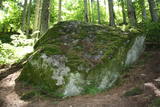 |
Vienu kilometru garā lokveida taka, kas ved pa lielāku nacionālā parka meža masīvu, uzskatāmi attēlo Žemaitijas augstienes un tuvākās apkārtnes reljefa veidošanās vēsturi. No takas augstākā punkta – Mikitai kalna, kas ir sens pagānu upurkalns, paveras (ainaviska stiga) tālākas apkārtnes skats. Kā takas interesantākie apskates objekti ir jāmin teikām apvītais akmens ar Velna pēdu un ar akmeņiem izliktas akas paliekas. |
|
 |
Kaut arī Augštaitijas nacionālo parku uzskata par floristiskā ziņā ļoti bagātu teritoriju, šī ir vienīgā vieta, kur varam iepazīt augu valsts bagātību. To īstenot palīdz takas malās izvietotie informācijas stendi. 3,8 km garās lokveida takas sākums ir meklējams Palūšē, Lūšu (Lūšiai) ezera galējā austrumu punktā. Taka ved gar ezera krastu, mežainām kāpām, nelielu strautu ielejām un pa purvāju. Nenomaldīties palīdz krāsu marķējums uz koku stumbriem. |
|
 |
The “backbone” to this park is the valley of the Šventoji (Holy) River. One of the most impressive Devonian cliffs in Lithuania can be seen from the river – Vetygalos atodanga. On the shores of the Varius stream is a cliff made of quartz and sand – Variaus atodanga. 6 km to the S of Anykščiai is Lithuania’s second largest rock (5.7 m high, ~100 m3) – Puntukas akmuo.
|
|
 |
This park is located in the northern part of the Žemaitija Highlands, and much of it is taken up by Lake Plateliai. The park was established to protect lakes, rivers, wetlands and forest ecosystems, as well as the local cultural environment.
|
|


