
| No | Name | Description |
|---|---|---|
 |
The Palanga Botanical Garden surrounds the Palanga Amber Museum and is one of Lithuania's most beautiful and well-kept parks. It is in the area of the St Birute Forest, and it is familiarly known as the Birute Park. The park covers 101.3 ha of land, and offers a wide variety of landscapes, carefully organised trails, flowerbeds, two ponds and small architectural elements. |
|
 |
The botanic garden is part of the Siauliai University and is the newest and smallest botanical garden in Lithuania, covering 6.54 ha of land. |
|
 |
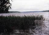
Located on an island in Lake Dviragio, the Salu Estate and its park, when viewed from above, are reminiscent of the boundaries of Lithuania. The park to the east of the estate is a mixed-type park and is one of the oldest ones in Lithuania. Back in the day, it was a forest park where trees were never cut down. The park featured maple, linden, elm, aspen and other local trees, and they are now around 200 years old. A winding path links the alley to a park trail by the lake. The various plants and fragments of alleys have survived to the present day. |
|
 |
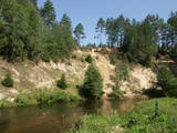
The “backbone” to this park is the valley of the Šventoji (Holy) River. One of the most impressive Devonian cliffs in Lithuania can be seen from the river – Vetygalos atodanga. On the shores of the Varius stream is a cliff made of quartz and sand – Variaus atodanga. 6 km to the S of Anykščiai is Lithuania’s second largest rock (5.7 m high, ~100 m3) – Puntukas akmuo.
|
|
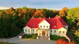 |
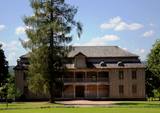
The Jakiškiu Estate was first mentioned in documents in the late 16th century. The estate had elements of Classicism in terms of its architecture. Among the buildings, the only ones that have survived are the mansion, an ice cellar and a steam-driven windmill. The estate has not been restored, so it is still authentic. Its artistic soul is preserved by various objects that remain from the time when people lived at the estate and from the Soviet era. Alongside the estate are a few fragments of a park, which covers approximately 2 ha. There is an ancient alley of linden trees that are on both sides of the entrance road, as well as several other valuable types of trees and a small pond. |
|
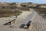 |
Die Dünen nördlich Pervalka über dem ehemaligen Dorf Negeln. Eine 9 km lange Strecke mit den wüstenartigen Landschaften. Stegpfade. |
|
 |
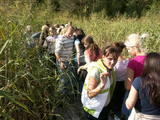
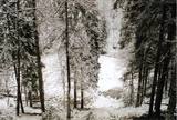
This territory is Lithuania’s most forested area, and people here have always lived in accordance with nature. Local treasures include berries, mushrooms, honey, clean water from streams and rivers, etc. People here have engaged in various crafts, as well as in beekeeping.
|
|
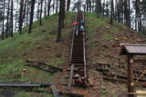 |
Viens no lielākajiem Augštaitijas pilskalniem, kas 2011. g. pēc vērienīgiem rekonstrukcijas darbiem ir izzināms jaunā kvalitātē - gan no infrastruktūras, gan arī ainaviskā viedokļa, jo iepriekš biezais pamežs (tagad retināts) traucēja uztvert iespaidīgo objektu. Arī no pilskalna plakuma paveras labs skats uz diviem blakus esošajiem ezeriem. Tā virsotnē apskatāms piemiņas akmens, kas vēsta par pirmā Lietuvas valsts prezidenta Antana Smetona (Antanas Smetona) apmeklējumu 1934. g. viņa 60 gadu jubilejā. Pilskalns it ticis apdzīvots jau I tūkstošgadē pirms Kristus. Uzskata, ka 14. – 15. gs. te atradusies hronikās aprakstītā Linkmenu pils. Jaunizveidotā taka pilskalnu savieno ar vēl vienu populāru apskates objektu – Ladakalni. |
|
 |
The Rietavas Park was once the largest landscape park in Lithuania. It was established between 1848 and 1855 in a naturally cleaned forest and reconstructed in 1904 and 1905. This is a very nice park with local bushes and trees, as well as several foreign plants. Various alleys of trees and fragments of the hedges have been preserved along with the white gate, the red gate and a guard's hut. The park has a complex system of bodies of water, including a few ponds, a curvy river and an island that is surrounded by the old river. |
|
 |
Kaut arī Augštaitijas nacionālo parku uzskata par floristiskā ziņā ļoti bagātu teritoriju, šī ir vienīgā vieta, kur varam iepazīt augu valsts bagātību. To īstenot palīdz takas malās izvietotie informācijas stendi. 3,8 km garās lokveida takas sākums ir meklējams Palūšē, Lūšu (Lūšiai) ezera galējā austrumu punktā. Taka ved gar ezera krastu, mežainām kāpām, nelielu strautu ielejām un pa purvāju. Nenomaldīties palīdz krāsu marķējums uz koku stumbriem. |
|
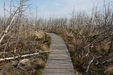 |
Nahe der Beerkopfdüne ist im Frühling 2006 „ein Brand der Jahrhunderte” gewessen. Es wurde der hundert Jahre alte Wald in der Fläsche von 235h ausgebrannt. Ein Pfad mit Holzbelag. |
|
 |
Reškutenu (Reškutėnai) ciema apkārtnē ir atjaunots neliels mitrājs, kura malā uzcelts putnu vērošanas tornis. Ja paveicas, pavasaros te var dzirdēt vai redzēt tādas retas un aizsargājamas putnu sugas kā ķikutu Gallinago media, ormanīti Porzana porzana, melnkakla dūkuri Podiceps nigricollis, griezi Crex crex u.c. Ciema ainava īpaši pievilcīga ir pieneņu un ābeļu ziedēšanas laikā. No putnu vērošanas torņa var redzēt vietas, kur akmens laikmetā dzīvojuši cilvēki. Blakus esošajā purvainajā pļavā bijis ezera līcis, kur tika būvēti ciemati līdzīgi kā Āraišu ezerpils gadījumā. |
|
 |
The only school-based botanical garden in Lithuania was planted in 1989 at the Traupis school. More than 8,000 types of plants grow in the garden, and all of them have been collected by Sigutis Obelevičius. |
|
 |
This territory in the northern part of the Dzūkija Highlands with lots of hillocks and lakes. The most interesting tourist destination is Velnio duobė (Devil’s Flowerbed) – a funnel-shaped hole that is up to 40 m deep and 200 m wide and is thought to have originated during the Ice Age.
|
|
 |
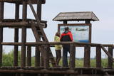
In der Umgebung von der 52 m hohen Parniddenen Düne sind die im 18. Jh. bei einem Holzeinschlag entstandene Wanderdünen zu sehen! Aussichtsplatz. |
|
 |
This is one of the most outstanding areas in the entire Baltic States with active underground waterways which still, to this very day, dissolve local gypsum rock. Parts of the area collapse regularly, and there are legends about all of this. Underwater rivers, streams, the so-called Karvės (Cow) cave, etc., can be seen in the area.
|
|
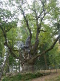 |
This is the thickest English oak (Quercus robur) in Lithuania, with a circumference of 9.4 m (as opposed to the Kaive oak in Latvia, which has a circumference of 10.18 m).
|
|
 |
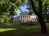
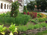
This estate is surrounded by an ancient and geometric landscape. During the latter half of the 19th century, it had a landscape style with various elements of geometry. The park covers 4.2 ha and has ancient linden, maple, elm, oak and other decorative bushes, with more than 20 types of plants that have turned into wood. |
|
 |
Ap 9,5 km garais un līdz kilometru platais ezers atrodas subglaciālā – t.i. ledāja veidotā vagā, tādēļ tas ir ne tikai Lietuvas, bet arī otrs Baltijas dziļākais ezers (pēc dažādiem avotiem 60,5 m vai 62,5 m). Tauragna dienvidu krastā paceļas Taurapils pilskalns (Taurapilio piliakalnis). Saglabājušies nostāsti gan par pagānu priesteri, kas te dzīvojis, gan nogrimušu baznīcu, gan laikiem, kad pilskalnu no visām pusēm apņēmis ūdens. No pilskalna plakuma paveras visaptverošs skats uz Tauragnu. |
|
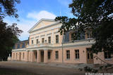 |
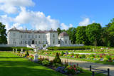
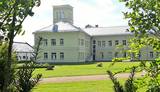
This is one of the most colourful and architecturally interesting parks in Lithuania. It was rebuilt and expanded between 1898 and 1900 by the renowned dendrologist G.F. Kuphaldt. The park had more than 200 types of plants, more than 100 of which are still growing. There are various roads and pathways that offer a sense of the mightiness and beauty of the park. A dendrological trail with markers offers information about 15 rare trees. |
|


