
| No | Name | Description |
|---|---|---|
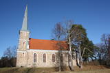 |
A wooden church was built here in 1766, and the new brick church was built on the foundations of the old church and consecrated in 1868. The tall steeple of the church helped ship captains orient themselves during the daytime. An altar painting by Gunta Liepiņa-Grīva, "Christ and Peter on the Sea," was consecrated in 1993 to replace the former painting, which was lost. The blue-white-green Livonian flag was consecrated at the Mazirbe manse (now a recollection centre) on November 18, 1923. Near the manse are several rocks which stand witness to the Black Plague in 1710 and 1711. The text in Latin said that Livonians on the coastline were conquered by Swedish King Karl IX and the bubonic plague. The texts on the rocks have eroded away, but records of them were made. The Mazirbe cemetery has a monument to Old Taisel, a monument to the parents of captain A. Bertholds, and the legendary grave of a werewolf. |
|
 6 days
|
On this hiking route you will see the most part of the western coast of Estonia from Pärnu to Tallinn. You will visit Estonia’s most popular resort cities: Pärnu and Haapsalu. You will pass along many bays, cape horns, fishermen’s villages and overgrown meadows. In the northern part you will walk along the spectacular Pakri cliffs, where you will see some of the most beautiful scenery in the area. There will also be sandy beaches and dolomite outcrops in places. In some rocky and wet sections you will use coastal forests and trails. During the route, you will see the Soviet military heritage in Paldiski. |
|
 |
The ship "Baltā Kaza" transports tourists along the Daugava and also acts as a ferry from Jaunjelgava to Skriveri. In the summer season it runs at regular times. Excursions and trips to the Love Island, Aizkraukle castle ruins, Ķegums HPP, etc. are also possible. Other routes are possible. 25 passenger seats. During the trips you can get acquainted with the narration of cultural-historical, historical and biological objects on both banks of the Daugava. The owner organizes events and concerts both on the Daugava and on the bank of the Daugava. Possibility to rent SUP boards, rowing and canoe boats, catamarans at the berth. |
|
 |
An all-encompassing view of the urban environment next to the Daugava River valley is offered at the car park which is at the start of Augusta Street on the boundary of Krāslava. The unique wooden buildings of the area (the Kaplava Street region) can also be seen on the bridge which crosses the Daugava. Climb Karņickis Hill and hike through the park of the Plāters family of nobles. From there, you will see more local scenes.
|
|
 |
Viengadīgo krāšņumaugu, ēdamaugu dēstu audzēšana. Dažādu krāsu un formu tomātu audzēšana segtajās platībās. Ar 2021. gadu tomātu pārstrāde - sulas un pulvera ražošana. |
|
 |
The café is located in the centre of Talsi, near Church Square, not far from Talsi lake. Latvian cuisine: Bean, sorrel and chilled soup, grit or pea porridge, sautéed vegetables and meat, homemade steak haché, grey peas with bacon, pork ribs, potato pancakes, whipped fool, fruit juice gelatine with milk. |
|
 |
A family-owned company that makes culinary and confectionery products in Jaunannas Parish, Alūksne Municipality. Delicious meat roulettes and rolls, prepared using Grandmother's recipes, and other meat products in a wide assortment, as well as special "Gustiņa" confectionery products can be purchased in Alūksne - taste store "Gustiņš". In the café “Gustiņš” you can enjoy a delicious and rich homemade meal, and taste the special dishes characteristic to the locals of Alūksne – malēnieši (booking in advance). |
|
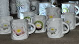 |
Since 2007, visitors have been able to tour a porcelain factory that offers an exhibition of porcelain products. You can buy souvenirs or commission special products. Children will love the porcelain painting studio that is in the mansion of the nearby Vecpiebalga Estate. |
|
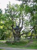 |
This park dates back to the mid-18th century and is to the south of Lake Stelmuže. There are winding trails on all sides of the hillock that lead to the Christ the King Church, with linden, maple, oak, birch, fir, elm and pine trees. At the foot of the hillock is the Laime stream, and visitors are welcome to stroll along the alley of oak trees. The oldest and fattest oak tree in Lithuania is one of the oldest ones in Europe. It is though that it is 1,500 to 2,000 ears old, and its record-setting diameter is 3.5 metres (eight or nine people linking hands are needed to encircle it). The tree is 23 m high. |
|
 3 days
|
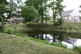
This is an easy 3-day route, suitable for any traveller ready to take some steps outside the capital and get into the woods. You will start the tour by taking a train from Rīga to Ķemeri. The walk will start in the Ķemeri resort park leading to the legendary sulphur spring and continue to the “Forest House” – the visitor’s centre of the Ķemeri National Park. The park is established for the protection of mainly wetlands – the shallow coast of the Gulf of Riga, the overgrown seaside lakes, the vast marshlands, mires (forests) and flood plans. Besides, there is the wooden plank Melnalkšņu swamp forest trail. Next, the Forest Trail takes one to the Lake Sloka, a shallow coastal lake with rich aquatic plants, sulphur springs and important migratory bird rest areas. On the banks of it, there is a 7 m high floating bird-watching tower. Further, the Forest Trail runs to the Gulf of Riga in the small fishermen village of Bigauņciems, where it joins with the Baltic Coastal Hiking Route (E9 European long distance path). From there on, the trail runs along the coast direction Jūrmala – the most popular resort town in Latvia with the widest sandy beaches. The tour ends in Ragakāpa Nature Park, which is established to preserve the dunes covered in old pine forests and natural diversity of the seaside. The Jūrmala Open-Air Museum is a place to get to know a traditional local fishermen’s farmstead. |
|
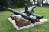 |
Dole Island is the largest river island in Latvia, and it is the site of the Dole baronial estate. The mansion of the estate was built in 1898 by the aristocratic family which owned the estate. Today the mansion is home to the Dole Museum with a rich exhibition which tells about the lives of people on the shores of the Daugava River. The adjoining park features ethnographic buildings, as well as lamprey and salmon spawning grounds. There are five unique cannons that were found in Salaspils when a new stadium was being built there. In 1910, a tsarist military camp was here, and a monument to Tsar Peter the Great was unveiled. One of the cannons is in the exhibition of the museum itself.
|
|
 |
A café in Baloži, located 11 km from Riga, that offers a wide range of dishes for every taste, from breakfast and snacks to a variety of main dishes, both from local and European cuisines. An especially friendly place for families with babies. |
|
 |
Plateļu dienviddaļā plešas sakoptais Plateļu muižas (muižas vēsture ir zināma, no 16. gs.) parks, kura centrā aug Raganu osis – dižkoks 7,2 m apkārtmērā. Parkā un tā tuvākajā apkārtnē ir redzamas muižas saimniecības ēkas. Vienā no tām – atjaunotajā zirgu stallī ir izveidots muzejs, kurā var apskatīt unikālas 250 vietējo meistaru darinātās maskas. Pašreiz šī ir lielākā šāda veida masku kolekcija Baltijas valstīs. Plateļu ezerā ir atrastas trīs no ozolkoka taisītas vienkoča laivas. Viena no tām (darināta 16. gs.) atrodas Lietuvas Jūras muzejā. Otra (15. gs.) ir apskatāma atjaunotajā Plateļu muižas graudu glabātavas pagrabā (Didžioji gatve 22), jo šobrīd tiek restaurēta. Trešā laiva arī izlikta apskatei kā muzeja eksponāts. |
|
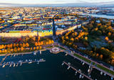 |
Helsinki is the capital of Finland and the biggest city in Finland. It offers a lot to see as it is seaside city surrounded by islands but city itself is full of wonderful parks. This city has everything to attract all kinds of people - from architecture and culture to nature and even has wide range of places where to enjoy night-time Helsinki. |
|
 |
Atrodas ceļa, kas ved uz Miķeļtorņa bāku – līkuma malā. Unikālā ēka (vienīgais lībiešu ciemu krogs ar raksturīgo plānojumu, kas saglabājies līdz mūsdienām) šobrīd atrodas avārijas stāvoklī un apskatāma tikai no ārpuses. Pizes krogs celts 1853. gadā. |
|
 |
The farm museum presents the life and activities of Carl Robert Jakobson (an outstanding 19th C public person, writer and teacher) and his farmstead. Visitors can see cattle, sheep, horses and renovated outbuildings. They can also test their skills in farm jobs; Estonian food is available if booked in advance. |
|
 |
The Skala silence home is on the banks of the ancient Nevežio river valley. You will be served happy dishes from everything that is grown at the farm. |
|
 |
The space is on the second floor of the Jūrkalne library, featuring traditional objects from Jūrkalne and the Suiti people, as well as several looms where locals organise creative workshops. Contact the chamber in advance to arrange for a guide who will tell you all about the culture and traditions of the Suiti and present a film about them. |
|
 |
The Ziemupe nature restricted territory is on the shore of the Baltic Sea, and it protects a wide variety of coastline biotopes. The distinguished grey dunes are found here, as are various kinds of forest biotopes, some of them quite rare in Latvia. There are many protected plants and animals in the area, too. The Akmensrags lighthouse and several tourist accommodations, like camping Laikas who "Sējējs" award, are in the territory. On the sea shore not far from center of Ziemupe there is well-appointed parking area with information stands. |
|
 |
The restaurant is in the centre of Jelgava among residential buildings. It is known for its interesting interior and for the musical and other events that it organises. Latvian cuisine: Farmer’s omelette, roast pork with chanterelles and wild mushrooms, grit risotto, strawberry soup with ice cream, crepes. Special foods: “Kiss from Šarlote” – layered egg-cottage cheese crème and jellied juices. |
|


