
| No | Name | Description |
|---|---|---|
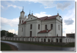 |
The Dviete Catholic Church is in the centre of the small village of Dviete. The white church can be seen from a distance. The first wooden church was built here in 1775 by the owner of the local estate, Count J.K. Wischling. Later the church was dismantled and brought the Zarinki cemetery. The Neo-Baroque Catholic church that is seen today has two towers, and its construction was financed by Count Kazimir Plater-Sieberg. The church was destroyed during World War I, and until it was rebuilt and consecrated, the granary of the Dviete Estate magazine, with its ridged roof, was used as a prayer house. It is on the side of the Dviete-Bebrene road and has recently been restored. In 1940, a stone fence was installed around the church with a tiled roof, and a building for the congregation was built in the 1970s. The church features a particularly ornate sacral Baroque interior, which is seen as the most ornate interior of its type in the former Daugavpils District. |
|
 |
The cafe is situated in the shopping centre Sala in Jekabpils, on the right back of the river Daugava. The cafe’s premises are comfortable and decorated with fresh flowers. It is a place where you can have either breakfast, dinner or supper. Working hours: 9.00 - 20.00 |
|
 |
One of the oldest botanical parks in Lithuania, this one was opened by Izidoras Navidanskas in 1928, when he was only 16. In 1965, the park because the Žemaitija botanical park, and Navidanskas and his son, Rapolas, who is the current owner, did a lot to expand it. |
|
 |
Preiļu Siers is the largest cheese manufacturer in Latvia and exports 90% of its output. There are three “Preilis” stores in the town (Daugavpils Street 66A, Tirgus laukums 5, Rēzeknes iela 15) where are the widest range of Preiļu Siers products. Three kind of tastings of cheese "Čedars" produced in Preiļi, as well as "Čedars" cheese ice cream and a movie about the company are offered by local home producers "Pampūkas" beach terrace cafe, located in the active part of the city - beach area of Preiļi Park (pre-registration by phone 25867735, runs from the second Sunday of May till the second Sunday of September). In Preiļi , next to A/S "Preiļu siers" factory (Daugavpils iela 75) is one of few monuments to cheese in the world – the only one of its kind in Latvia. There are only four monuments for cheese in the world, two of them located in France, and one in each - Canada and USA. Therefore Preili can safely be called the cheese capital of Latvia. |
|
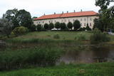 |
One of the largest castles in Kurzeme, this building has been preserved in fairly good shape. Work on its began in the mid-13th century, and it was commissioned by the heads of the Dome Cathedral in Rīga. In 1434, the estate was bought by the bishop of Kurzeme. The Maidel and Osten-Sacken dynasties owned it from the 16th to the 20th century. The Dundaga Castle burned down twice and has been rebuilt many times. The last reconstruction was in 1905, after the castle was burned down during the revolution. Of interest on both sides of the castle’s door are stone carvings of a knight and a bishop. In recent years, the hotel in the castle has been renovated, as has the second floor hallway and a terrace that is popular for weddings. There are many legends about the castle, including one about a wedding of elves and another about the Green Lady. Today the building houses the Dundaga School of Music and Art, a hotel, party rooms, the Dundaga Tourism Information Centre and various exhibitions. It is worth finding a guide to tour the castle. Groups of tourists can also order tastings of local foods. |
|
 |
Atrodas Kalēju ielas malā. Savu popularitāti ieguvis ar nostāstu, ka Ziemeļu kara laikā pie tā pusdienojis Krievijas cars Pēteris I un Polijas valdnieks Augusts (Stiprais). |
|
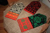 |
The basic exhibition at the museum, “Traditions Related to the Sewing and Wearing of Bārta Folk Costumes From the 19th to the 21st Century”, features folk costumes for unmarried and married women, as well as for men, emphasising the diversity of elements therein. Visitors can help to embroider or weave blouses. The Bārta Ethnographic Ensemble offers two educational programmes – “The Bārta Folk Costume” and “Singing Women From Bārta”. |
|
 |
The farm has a fabulous apple orchard and also grows potatoes and strawberries. You can buy apples and taste strawberries. |
|
 |
This company is proud of more than 100 years of history. Today it is the third largest cheese manufacturer and sixth largest dairy processing company in Latvia. It partners with some 150 Latvian providers of high-quality milk. Smiltenes Dairy is the only one to manufacture “Latvian Cheese.” The company’s products have been awarded the “Green Teaspoon” award. Smiltenes Dairy exports products to five countries in the world and has a nearby store where you can purchase its products. |
|
 |
Dievnama mūri kā svētvieta glabā ne tikai svētuma starojumu, mierinājumu, bet arī smagus, rūgtus un iznīcinošus notikumus. Vairākkārt pārbūvēta, sagrauta, dedzināta, un tomēr atjaunota. |
|
 |
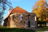
Gebaut als ein Gebäude des Festungstyps. Wurde in der Zeit des Livländischen Kriegs und des Nordkriegs zerstört. 1865 wurde der heutige Turm gebaut. Die von J. V. Rabe gebaute Kanzel mit Spindeltreppe. |
|
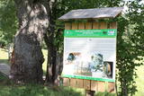 |
Interesanta dabas izziņas taka, kurā izvietoti informatīvie stendi, kas stāsta par dažādiem pļavu biotopiem – sausām, palieņu un parkveida ozolu pļavām un tās iemītniekiem. Pļavas nogana dzīvei savvaļā pielāgotie mājlopi. |
|
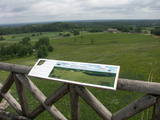 |
This park is in a region of hillocks in the Karula highlands, and Lake Ähijärve is at its centre. The park offers a cultural environment of small farms, and it was set up to protect the unique cupola-shaped hillocks of the area. Main attractions: Scenic Lake Ähijärv (176ha), Rebasemõisa Tornimägi hill (137.8 m above sea level), undulating landscapes. |
|
 |
The number of types of peonies in this garden is close to 400, and collect Dagnija Voika is proud of one of the largest collections in Latvia. There are 30 types of shrub peonies, and other flowers that grown there include bearded irises, Siberian irises, daylilies, as well as less common plants such as yuccas and eremurus. The garden is open in June, when the owner organises a peony festival and offers tours. The valuable peony roots are used to produce the PEO series of cosmetics, and plants can be purchased. |
|
 |
Apmeklētājiem tiek piedāvāta ekskursija ar stāstiem par Limbažiem, kas kādā veidā saistīti ar sudrabu. Ekskursijas laikā iespējams apskatīt paraugdemonstrējumus lodēšanā. Sadarbībā ar juvelieriem, darbnīcā būs iespējas apgūt prasmes darbam ar misiņu un sudrabu, tiks piedāvātas arī meistarklases. Pēc iepriekšējas pieteikšanās grupām būs pieejamas arī O.Auzera lekcijas par sudraba ietekmi uz veselību. Ekspozīcija atvērta apmeklētājiem no trešdienas līdz svētdienai no pl.10:00-17:00, citā laikā grupām- pēc iepriekšēja pieteikuma. Ieejas maksa: |
|
 |
Beķereja, veikals un kafejnīca atrodas Vaiņodes centrā. Saimniece cep pīrāgus, cepumus un plātsmaizes Latgales meistara mūrētā maizes krāsnī, gatavo tradicionāli latviskus ēdienus, klāj svētku galdus. Beķerejas veikalā var iegādāties ceptuves gardumus un uzzināt par apkaimes interesantākajām vietām. Par dienas aktuālo piedāvājumu beķerejas saimniece ziņo facebook.com/ineta.zveja . |
|
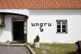 |
Ungru is a seaside hotel in the north of Hiiumaa. There is a high-class restaurant on the ground floor. The second floor has 4 rooms with all amenities. Dauble Deluxe beds with sea views. |
|
 |
Atrodas Vecpiebalgas centrā pie Inešu ceļa. Vieta, kas jāapmeklē katram savas valsts patriotam, jo šeit atdusas leģendārā romāna "Mērnieku laiki" autori - brāļi Reinis un Matīss Kaudzītes, sabiedriskais darbinieks un valodnieks Atis Kronvalds u.c. Kapos apskatāmi brāļu Kaudzīšu un A. Kronvalda pieminekļi. Tos atrast palīdzēs izvietotās kartes un norādes. |
|
 |
Ap 6 km garā pussala ir vieta, kur jānokļūst tiem, kas grasās doties vienā no neparastākajiem pārgājieniem pāri jūras šaurumam. Cauri Kūsnemmes pussalai līdz tās ziemeļu daļai iet šaurs un ļoti līkumains grants ceļš (ar garāku tūristu autobusu jābrauc lēni un uzmanīgi), kura galā izveidots autostāvlaukums, neliels namiņš, kur patverties lietus un vēja laikā, kā arī informācijas stends. Turpat redzamas divas Padomju armijas „KRAZ” tipa automašīnas. Lai sasniegtu robežkontroles posteni, Padomju robežsargi brauca pa jūru un mazajām saliņām, kas kā pērļu virtene savieno Kūsnemmes pussalas galu ar Vilsandi salas dienviddaļu. Turpat divas desmitgades pēc Igaunijas neatkarības atjaunošanas „KRAZ” automašīnu kravas kastēs vasaras laikā uz Vilsandi vizināja tūristus, taču spēkrati savu mūžu ir nokalpojuši un unikālais piedāvājums vairs nav spēkā! Ko darīt? Pa mazajām saliņām uz Vilsandi var doties ar kājām. To var īstenot tikai siltā laikā, kad nav gaidāms stiprs vējš un ir zināma laika prognoze vismaz divām tuvākajām dienām. Kā sava veida orientieris var kalpot augstsprieguma elektrolīnija. Kopumā ir jārēķinās arī ar 1 h 40 – 2 h ilgu un ~ 4 km garu gājienu. Dziļākā vieta (ja ietur pareizo „kursu”) atrodas pārgājiena sākumdaļā, kur starp saliņām izveidots laivu ceļš - ~ 1 m dziļa vieta atkarībā no vēja virziena un ūdens līmeņa. Zināmu priekšstatu par maršrutu sniegs redzamā ainava, kas paveras no skatu torņa. Kaut arī šis maršruts tiek reklamēts dažādos informatīvajos materiālos, atbildību par tā veikšanu uzņemas katrs pats! |
|
 |
Kakaiši is found 1 km to the South-West from Vecpiebalga, in the tiny village of Kakaiši. The Latvian writer Antons Austriņš (1884-1934) was born there and went to school in Vecpiebalga. Austriņš is best known for the short story collection “Puiškans” (1931). The museum features various rural objects, things associated with the author, and exhibits such as his collected works and other books that are worth visiting in the company of a guide. |
|


