
| No | Name | Description |
|---|---|---|
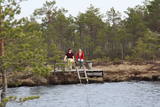 |
1,2 km gara taka, kas pa purvainu mežu aizved līdz Ērdi purvam (Öördi raba) un tā austrumu daļā esošajam Ērdi ezeram (Öördi järv), pie kura izveidota atpūtas un peldvieta. |
|
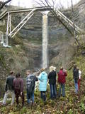 |
This is a cliff with various levels. Known as the North Estonian cliff, it stretches all along the shore of the Bay of Rīga in Estonia, including some of the local islands. The most expressive part in geological and landscape terms is the Saka-Ontika-Toila cliff, which is around 22 km long and offers an unusual natural environment. The cliff is as much as 53 m high, and it has a fairly virginal forest along its slopes. The layers of clay, sandstone, limestone, etc., come from the Cambrian and Ordovician periods. The Valaste juga (Valaste waterfall) is 24 metres high. After a longer period of freezing temperatures, the waterfall has a particularly impressive appearance. Seasonal waterfalls (8-10 m) can be found near the villages of Ontika and Toila.
|
|
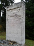 |
The monument is at the location where the P100 road to Ozolnieki and Jelgava splits away from the A8 highway. The monument is dedicated to soldiers from the 6th Rīga Infantry Company who perished or disappeared during battles against the army of Bermont on November 17, 1919, near the former Skuju Elementary School. The monument was designed by Nikolajs Voits, the bas relief was designed by Mārtiņš Šmalcs, and the consultant for the project was the great sculptor Kārlis Zāle. The monument was unveiled on October 24, 1937, and restored in 2009. |
|
 |
The guest house is located in Odziena, Vietalva Parish, Plavinas Region. The house has 5 bedrooms, guests can enjoy a sauna, a pool and a swim in the pond, as well as fishing. There is a large surrounding area for organizing activities and other classes - the guest house is suitable for both relaxation and celebrations. |
|
 |
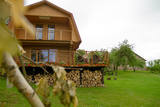
The Vijciems Hunting Castle building houses an elegant design guest house Bergervilla. Each room has an individually designed design, historic furniture and a special atmosphere. There are 4 rooms available - a standard room, a two-room suite and two deluxe rooms with a private balcony and a bathtub. Each room is given the name of a forest beast or bird - Owl, Mednis, Deer and Elk. There is also a living room and library for guests to relax in, as well as a fully equipped kitchen for cooking. Free Wi-Fi and parking are available. |
|
 3 days
|
From Riga the route goes to the historic Estonian sea resort and then by ferry to Muhu island. On the way there is ethnographic village of Koguva, the Liiva church and the elegant Padaste Manor. Overnight at Muhu island. 28 km cycling there juniper fields, its small fishing villages, and the magnificent Juigu cliffs, which open up a view of the other small islands in the Monzunda archipelago. Then drive to Saaremaa and stay in Kuressare, the island's capital. There the rooute covers such attractions as Kaali meteorite crater, impressive Valjala church and castle mound, Piretikivi rock and Poide church. Cycle along the Tagameisa Peninsula, up to 30 km. Driving to the ferry take a loop along Viidumae National Park with its viewing tower, Kihelkonna Church, the Odaletsi streams and nature trail and the dolomite Panga cliffs. |
|
 |
The most important aspects of this park are a shallow lagoon-type lake – Lake Pape, with its flood land meadows, the shore of the Baltic Sea, the Nida swamp, and the more than 270 different types of birds that have been spotted here. The oldest bird ringing station in Latvia (est. 1966) is found between Lake Pape and the Baltic Sea. Birds and bats are caught and ringed there. Lake Pape is the first place in Latvia where so-called “wild” horses (the “Konik” breed) were released with the aim of managing the flood land meadows.
|
|
 |
The trail tells about grey dunes which have survived thanks to the border restrictions and the presence of military. The trail starts from the parking place at the mouth of the Užava river. It is one of the few natural rivermouths in Europe. One can also see the „tacis”, an industrial installation for lamprey (Lampetra fluviatilis) fishing during their spawning migration period. The 3km long trail is circular. It winds for 1.5km from the Užava rivermouth to the North, along the coastline (the beach is covered with sand and pebbles), and returns to the starting point by a gravel road through grey dunes. Along the trail, one can observe a distinct white dune with rare plant species Linaria loeselii, Lathyrus maritimus, Anthyllis arenaria, Tragopogon heterospermus. About 1km from the rivermouth, in the sea, one can see a wrack of a sailing ship (parts of frame). The visibility depends on the flow of sand in the sea. The way back opens a beautiful view of the range of grey dunes. Unfortunately, Scots Pine starts taking over the area. There are three important biotopes of EU significance: „Fixed dunes with herbaceous vegetation 2130”, „Decalcified fixed dunes with Empetrum nigrum 2140” and „Dunes with Salix arenaria 2170”, forming a unique mosaic. Typical species here: mountain Alison ‘(Alyssum gmelinii), Pasqueflower (Pulsatilla pratensis), Sand Pink (Dianthus arenarius), Rosemary Leaved Willow (Salix rosmarinifolia), Dark Red Helleborine (Epipactis atrorubens), Kinnikinnick (Arctostaphylus uva-ursi). As a former military site, some military constructions can be seen here like horseshoe-shaped sand ramparts by the road in gray dunes. They were built to disguise military vehicles in case of sea attack. By the Kangroti graveyard, towards the Užava river, there is an underground pillbox. It is a one-man fortification to fire along the coastal perimeter. The Mouth of River Užava walking route is in the nature reserve „Užava” |
|
 |
Pühtittsa Convent at Kuremäe was established in 1891 and is the only operating Russian Orthodox nunnery in Estonia. Centuries ago there was a sacred grove on Kuremäe hill and a sacrificial spring at its foot, the spring is considered “holy“ for its curative powers. The convent compound is open to visitors; guided tours run by nuns can be booked to learn more about the daily life of convent residents. |
|
 |
Offering – a beach created in the quarry as well as the relaxation zone. 2 volleyball playgrounds, swings, trampolines, inflatable attractions. For the youngest kids – water joys in a specially constructed water „eyecup”. In a separated quarry you are offered to fish - trouts, carps, brook trouts, sheatfish. It is possible for you to cook fish, fry, make fish soup. In this case, we offer you all the necessary things for cooking. Fishing takes place all year round. |
|
 |
Place for bird ringing and bird watching. |
|
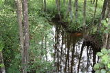 |
This territory is on both sides of the central section of the Raķupe River. On the banks of the river, there are many different meadow habitats, as well as massive oaks growing in the places of former farmsteads which are uninhabited by now. This is an important place for rare plants and animals. There is no tourism infrastructure for visitors in the area. Visitors who are especially interested in the environmental cognition are advised to visit the territory in attendance of experienced local guide. Raķupe is not usable for water tourism because of tilts of trees and beaver dams. |
|
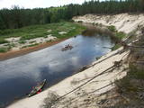 |
This comparatively large territory is found to the South of the Irbe River and Stende River, and it is unique with more or less virginal forests and dunes. The Irbe River has a system of ancient tributaries, and the Dižpurvs swamp is parallel to the shoreline. The Irbe has become a popular river for water tourism in recent years, but the tourist infrastructure on its banks remains insufficient. Territory has good road connections and has potential for nature education activities. |
|
 |
“Saules veltes” ir mājas vīna darītava Salaspilī, kas nodarbojas ar mājas vīnu, liķieru un degvīnu gatavošanu. Alkoholiskie dzērieni tiek ražoti no dabīgiem dārza augļiem un ogām, tostarp upenēm, avenēm, cidonijām, pīlādžiem un pat mārrutkiem. Apmeklētājiem ir iespēja aplūkot saimniecību (uzņem arī 15-20 lielas tūristu grupas), kā arī degustēt konkrētos dzērienus, kurus arī turpat ir iespējams iegādāties; piedāvājumā lieli un mazi tilpumi, dāvanu un suvenīru komplekti.
|
|
 |
A small and forested territory with sulphurous springs, among which the most popular one is the Ellīte sulphur spring. It has sulphurous water with a low level of minerals, and the water supposedly has medicinal properties. The area around the stream is well-appointed, and a pathway leads to it. The stream is considered to be the source of the Iecava River. The restricted area is there to protect biotopes and protected plants which are in the area.
|
|
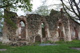 |
Lullemē atrodas blakus parka robežai, bet arī šo vietu ir vērts pieminēt kā vienu no apskates objektiem. Lullemē uzmanību piesaista viena otrai blakus stāvošās baznīcas. Mūsdienās redzamās 15. gs. celtās Sv. Marijas baznīcas drupas ir liecinieks 2. pasaules kara notikumiem, kad 1944. g. baznīcu sagrāva. Jaunā baznīca ir celta 1997. gadā. Ciema rietumdaļā uzstādīts piemineklis, kas veltīts brīvības cīņās (1919. – 1920.) kritušajiem. |
|
 |
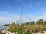
The Plāņciems missile base is in the forests of Bārta and is not easy to access. This special air defence facility is being dismantled for the purpose of obtaining building materials.
|
|
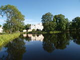 |
The castle, built in 1880 by von Pistolkors family, has been renovated and awaits guests in its new splendour. Guesthouse 78km from Riga. Premises for banquets, wedding, seminars. Sauna, swimming pool. Cultivated landscape.
|
|
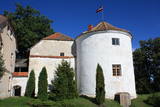 |
The first stone castle in Alsunga was built in 1372, starting with the central part of the southern wing. The authorised representative of the Livonian Order, who was subject to a higher-ranking official in Kuldīga, lived here. The guard towers and other parts of the castle were gradually added between the 15th and the 18th century. The Baroque castle with its two towers is quite impressive. The castle is unique in and outside of Latvia in that it is one of the rare Medieval castles to have survived to the present day in part, but in its original historical appearance. The castle offers an exhibition about its history. Visitors can look at a Suiti kitchen, write a letter with a fountain pen in Barbara’s boudoir, or celebrate a special event in the romantic venue of the castle’s round tower. Renovation of the castle began in 2018, and it is closed to visitors. Still, you can look at its exterior and tour its garden. |
|
 |
This park is in an area which has not been affected much by humankind – sandstone cliffs, an undisturbed diversity of caves, other habitats, species and landscapes is the attractive aspect of this area. The Salaca River is one of the most important rivers in the Baltic Sea region for the spawning of salmon, and it is the second most popular river for water tourists in the Latvian region of Vidzeme. There are geological monuments which are very attractive to visitors – the Red cliffs, Skaņais Hill, the Neļķu cliff, the Velna (Devil’s) cave, etc. There are also cultural monuments such as the Livonian castle hill, the Vecsalaca baronial estate, the Livonian Museum, the Vantenberģi estate, the unique Salaca lamprey weirs, etc. Also in the park is one of the most popular tourist destinations in Northern Vidzeme – the Skaņākalna park, which has a dense network of footpaths. The Salaca is also popular among fishermen. This is part of the Northern Vidzeme Biosphere Reserve. |
|


