
| No | Name | Description |
|---|---|---|
 |
The outworker offers different garlic and other vegetable products: marinated garlic flowers, different mixed vegetables; dried garlic rusks, etc. The groups are offered food tasting. |
|
 |
A popular café, located in the centre of Sigulda, just opposite the railway station, that offers breakfast, salad, snacks and main courses. Natural and truly delicious pastries, cakes and culinary products. |
|
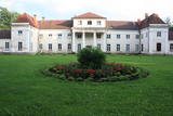 |
The Varakļāni Estate has a mansion which is known as one of the most outstanding monuments to Classicism in Latgale. It was built between 1783 and 1789 and designed by the Italian architect Vincento Macotti, and it was owned by Earl Michael Johan Borch. Late in the 18th century, the same architect designed the estate’s lovely and romantic landscape park, which was one of the first parks of its kind in Latvia. The Varakļāni Administrative District Museum is housed in the mansion today. |
|
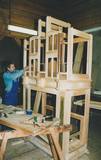 |
This is the only place in Latvia where old organs are restored and new ones are built. The workshop also manufactures music boxes. Tour groups can learn about the history and principles of organ building and about the instruments as such. The workshop was installed in the stable of a former manse in 2004, and it is owned by Jānis Kalniņš. |
|
 |
Puises „centrā” uz vienstāvu koka mājiņas jumta izveidota skatu platforma. No tās paveras laba ainava uz ciemu, ostu un piekrastes kadiķu laukiem. |
|
 |
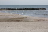
One of the most interesting objects in Bigauņciems, the road begins at the seashore, crosses the Vecslocene River (there is no bridge, but hikers and bikers can get across it), and then continues as a forest road to Lake Melnezers. |
|
 |
Piemājas zoodārzs "Brieži" atrodas netālu no Rīgas. Šeit sastopami daudzi un dažādi dekoratīvie putni, tītari, pīles, fazāni, pāvi un žagata, starp tiem dzīvo jūrascūciņas un truši. No četrkājainajiem draugiem te var sastapt Holandes pundurkaziņas, Haidšnukes aitas, Šetlandes ponijus, ēzeļu ģimeni, vāverēnus un jenotpuiku Bārniju. Zoodārzu palīdz sargāt zosu bariņš un Peruāņu pundursivēns - Pigis. No 2015. gada Briežos dzīvo arī dambrieži un briedis Munžaks. Pēc pastaigas zoodārzā, iepriekš piesakot, iespējams izmantot piknika vietas un bērnu rotaļu laukumus. |
|
 |
An important complex of the coastline and its sand dunes along with the mouths of three major rivers – the Lielupe, the Daugava and the Gauja. This area has ancient traditions of recreation and spa services. The territory has lovely shoreline landscapes and features one of the few coastline meadows in Latvia. The nature park includes several restricted areas – the meadows of the Lielupe estuary, Vakarbuļļi, Daugavgrīva, Vecdaugava and Ummis (see the section on “Restricted Natural Areas”). Interesting elements of nature in this area include the amphitheatre of the Garciems dunes, along with individual dunes such as the Legzdiņi dune and the so-called ski mountain dune. Visitors will be attracted by various cultural and historical monuments – fortifications on the Mangaļi peninsula, military buildings from the period of the Russian tsars all the way through the late period of the Soviet occupation, the fortress of Daugavgrīva, the Vecāķi spa with its old shoreline buildings, and the beaches at Daugavgrīva and Vecāķi. The proximity of the city of Rīga and various important recreational resources are the reason for the massive anthropogenic burden that is placed on this territory. The nature park is appropriate for active tourism (hiking, bicycling, boating, driving), distance skiing, nature and bird-watching, cultural tourism, passive leisure and educational tourism. There are nature trails at Daugavgrīva and the Rožu dunes, along with other elements of infrastructure. |
|
 |
This is an enormously important territory for migrating birds. The most commonly spotted protected species of birds are the velvet scoter, the black scoter, the long-tailed duck, the little gull, the red-throated and black-throated loon, and the black guillemot. The territory is opposite the Dundaga and Ventspils administrative districts, and it covers 172,412 hectares.
|
|
 |
Atrodas Ķekavā, autoceļa Rīga – Grenctāle (A 7) malā. Iekārtots vēsturiskā ēkā ar atbilstošu koka interjeru. Piedāvā maltītes visām ēdienreizēm, organizē muzikālus vakarus. |
|
 |
The Gardening Institute is the leading scholarly centre for fruit and vegetable research in Latvia. The institute specialises in selection and introduction of plant cultivars that are suitable for cultivation under the agro-climatic conditions in the Baltic countries, have high nutrition value and are rich in fibre content. |
|
 |
Starp steķiem un Tūjas ķieģeļu fabriku bija
izveidots sliežu ceļš, pa kuru transportēja labākās kvalitātes ķieģeļus.
Pēckara gados „Dzeņu” krastā uzcēla zivju pārstrādes rūpnīcu, bet pāri
steķiem – cauruli, pa kuru ar ventilatora palīdzību sūknēja zivis no kuģiem,
kas bija piestājuši steķu galā.
|
|
 |
This is a farm which produces beef. You can take a tour, during which you can learn about, taste and purchase untraditional herbs and exotic tea plants. |
|
|
|
Xранилище старинных предметов находится на втором этаже здания Туристического информационного центра в Нице. Здесь представлен более чем столетний народный костюм Ницы со всеми неотъемлемыми принадлежностями - юбкой, корсажем, кафтаном и шапкой с «ушками». В ницанском сундуке для приданого хранятся работы местных рукодельниц, которые продолжают местные ремесленнические традиции. Посетители могут ознакомиться с ницанскими одеялами, платками, скатертями и другими пригодными в хозяйстве вещами, а также с рукавицами и носками. |
|
 4 days
|
Маршрут ведет вдоль обоих берегов судьбоносной реки латышей – Даугавы. В маршрут включены такие значимые места, как развалины Кокнесского замка и создаваемый «Сад Судьбы». Путешественников порадуют как чудесные виды на речные ландшафты, так и древние городища, латгальские гончарные традиции и другие мастера ремесел. Даугавпилс с предложением многообразного военно-индустриального наследия и художественным центром знаменитого художника Марка Ротко. Информация о маршруте от Latvijas Lauku forums |
|
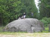 |
This territory was established to protect various kinds of rare butterflies A popular tourist destination in the Nīcgaļi forests is the great rock of Nīcgale, which is the largest rock in Latvia – a geological and geo-morphological monument of nature. The rock has a circumference of 31.1 metres, and it is 3.5 metres high, 10.5 metres long and 10.4 metres wide for a total size of 170 m3. |
|
|
|
Uzcelts Kaņiera pilskalnā un ir Kaņiera pilskalna takas sastāvdaļa. No torņa paveras izcila Kaņiera ezera dienvidrietumu daļas ainava ar niedru saliņām un nelieliem atklāta ūdens laukumiem. Laba putnu vērošanas vieta. |
|
 |
Saimniecība atrodas Ziemeļvidzemes biosfēras rezervātā, netālu no Burtnieku ezera. Tajā audzē kazas un gatavo kazas sieru. Saimnieki rūpīgi seko līdzi dabas procesu ciklam un ciena dabai draudzīgu dzīvesveidu. Papildus sieram sezonāli iespējams iegādāties arī upeņu ievārījumus, zāļu tējas un vilnas izstrādājumus. SieriTiek piedāvāts baltais, svaigais kazas siers bez piedevām. Tāpat pieejama kazu piena karamele - smēriņš. Kā top siersSiers top ilgi un pacietīgi visa gada garumā no pašu saimniecības kazu piena. Tā ir pilna cikla saimniekošana: saimnieki stāda, ravē un novāc ražu, ēd paši un dod ēst kazām. Kazu dziļās kūts uzkrājumi katru rudeni tiek vesti uz lauka, lai katru nākamo gadu “atdzimtu” ēdamajos dārzājos. ApmeklētājiemTā kā kazu pienam ir sezonāls raksturs, piedāvājumā divu veidu apmeklējumi:
Kur iegādāties sierusSaimniecībā uz vietas, Slow Food Straupe tirdziņos, Vidzemes lielākajos gadatirgos. Internetā: https://tirgus.novadagarsa.lv. |
|
 |
Here you will learn about the history and cultural heritage of the Liv people of Vidzeme. Tour the museum and enjoy once characteristic foods from the region – special porridge and a strong alcoholic beverage brewed in accordance with ancient recipes. If your group wishes to do so, it can take part in the baking of rye bread in a true country oven. |
|
 |
Kretoņu (Kretuonas) ezera dienvidu krastā (ezeru gan neredz aizauguma dēļ) meklējams Kretoņu ciems. Šķiet, ka šī vieta ir „aizķērusies" pagātnē. Cauri ciemam iet viena iela, kurai abās pusēs izvietojušās 19. – 20. gs. mijā (dažas pat mazliet agrāk – 19. gs. vidū) celtās saimniecības. Te redzamas gan dzīvojamās, gan saimniecības ēkas, kuras rada etnogrāfiska brīvdabas muzeja sajūtu. Dažas no tām gan ir „padevušās" laika zobam. Lai vai kā, šis ir viens no neparastākajiem nacionālā parka etnogrāfiskajiem ciemiem, kuru pa „galveno ielu" vērts izstaigāt visā garumā. Šim, tāpat kā pārējiem etnogrāfiskajiem ciemiem ir piešķirts kultūras mantojuma objekta statuss. |
|


