
| No | Name | Description |
|---|---|---|
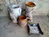 |
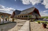
The ceramicist works in the household building of the Durbe Castle. You can watch her at work, try your hand at ceramics work, order artworks and purchase clay souvenirs. You can also tour the Durbe Castle complex, which is undergoing renovations at this time (2013). |
|
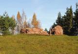 |
Swedish scanst (Kuce Hill, Jumprava Hill). Medieval fortification. The monument of national meaning
is located in the village Stari 450 m from Atspuki mill, 70 mto the Southeast from the ruins of Jumpravmuiža.
The territory is 0,7 – 1 m deep outside and 1 – 1,5 m high inside. The new road to the ruins of Jumpravmuiža
leads through the West side of the fortification.
|
|
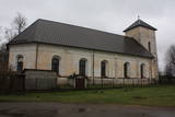 |
Atrodas Grobiņas centrā, Dzērves laukuma malā. Pirmā baznīca Grobiņa bija celta jau ap 1560. g., bet nākamā – 1596. g. celtā iznīcināta 1659. g. zviedru iebrukuma laikā. Pēc Kurzemes un Zemgales hercoga Jēkaba Ketlera iniciatīvas 1664. g. tiek uzcelts jauns dievnams, ko atjauno 1892. gadā. Tas dedzis 2. pasaules kara laikā, bet vēlāk atkal atjaunots. Šobrīd notiek altāra restaurācijas darbi. |
|
 |
Mācību drava "Kāre" piedāvā iepazīties ar bišu valstības noslēpumiem. Interesanta iepazīšanās ar brīnumiem un noslēpumiem bišu saimes dzīvē. Apmeklētājiem ir iespēja ietērpties speciālos aizsargtērpos un bitenieka vadībā iepazīties ar dzīvas bišu saimes smaržu. Veselībai un dzīvespriekam iespējams iegādāties - medu, bišu maizi, bet romantiskai noskaņai - smaržīgas bišu vaska svecītes. |
|
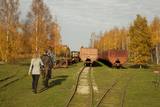 |
Sedas purva kājnieku maršruts atrodas dabas liegumā Sedas purvs, pārgājienu pa maršrutu iespējams apvienot ar Sedas pilsētas apskati, kas ir unikāls 20.gs. 50.–60. gadu pilsētbūvniecības un arhitektūras paraugs - kūdras purva strādnieku pilsēta. Maršrutam ir divi apļi - Jērcēnu aplis - 5,5 km un Sedas aplis - 4,2 km. Tajos apakatāms izstrādātais kūdras purvs, šaursliežu dzelzceļš, ritošais sastāvs, divi skatu toņi. Rudenī un pavasarī - putnu migrācijas lāikā - interesanta vieta putnu vērošanai. GPS koordinātes: Jērcēnu puses aplim: 57.7055987, 25.7001324; Sedas puses aplim: 57.6699587, 25.7514815. |
|
 |
1855, als einen Schiffahrtsweg getieft wurde, wurde im Haff unerwartet eine Bernsteinablagerung gefundet. In der Zeit zwischen 1860 und 1890 wurde dort 2250 Tonen Bernstein gewonnen, einbezogen einzigartige Bernsteingegenstände aus der Jungsteinzeit und der Bronsezeit. |
|
 |
The historic stone, on which there is carved over 200 years old boundary-mark, sets the border between the Duchy of Courland and the Russian province. Nowadays, it sets the Babīte and Jelgava district boundary. The stone lies to the East of Kalnciems–Peat road (the south of the swamp Labais purvs) at the edge of a forest firebreak and it can be hard to find. To this end, the description of the road map may help: around 400 m south of the car parking lot at Lily Lake from Kalnciems-Peat road to the right (in the east) turns a forest road which leads down from hills Krāču kalni. It should be around 170 m to go until it abruptly turns to the right (to the southeast). Then you must go in this direction until after ~ 0.5 km to turn to the northeast where after further ~ 0.4 km of the current forest road intersection turn to the north. After ~ 0.4 km turn right (to the east) on a big firebreak, on the left (the north) side of which behind the drainage ditch during the non-leaf period there can be seen a rounded stone. Due to the poor condition of roads, the stone can be reached only on foot. |
|
 |
The Healing Gardens is a part of the Upmaļi biological farm that occupies 125 ha of land. The 4th generation of Bergmanis family runs the farm. Māra and Dainis, the present farm owners, involve their family members to work for preservation of the old and rare fruit and berry cultivars that have been planted in the 30-ties of the previous century. The gardens also contain tree varieties that have medicinal powers and some rare varieties like elder, walnut tree, edible chestnut, mulberry tree and others. Together with the herb plantations, the Healing Gardens cover over 12 ha of land. The hosts have over 30 years experience in natural healing and Ayurvedic tradition. Based on this experience, they produce teas, balsams, creams, oils and other products under the brand name AnnaABergmans. |
|
 |
This territory in the northern part of the Dzūkija Highlands with lots of hillocks and lakes. The most interesting tourist destination is Velnio duobė (Devil’s Flowerbed) – a funnel-shaped hole that is up to 40 m deep and 200 m wide and is thought to have originated during the Ice Age.
|
|
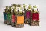 |
In the farm "Ozoliņi" organic tea is produced. With brand "Lauku tējas" tea has been sold in stores more than 17 years. Hostess is happy to share her knowledge through seminars and tea workshops. The farm is surrounded by forests and biologically valuable meadows where you can find up to 50 plants per square meter. |
|
 |
Lieliska vieta svinībām vai atpūtai Minijas ielejā Žemaitijā. Kafejnīca 100 pers. un konferenču zāle, kuras izvietotas 6 ha lielajā teritorijā. Spēļu laukumi gan bērniem, gan pieaugušajiem. Kanoe, burbuļvanna un pirts. Nakšņošanai viesnīcas numuriņi, koka namiņš vai 2-zvaigžņu kempings. Pieejama ēdināšana. |
|
 |
Close to Otepää, in a very beautiful place, surrounded by woods and hills, Canterville loss is waiting for you. A great place to relax with your family. Large playground for children. The restaurant serves both romantic meals and lunch during workshops. |
|
 |
For the first time, Balvi as populated area was mentioned in 1224. In the turn of 19th and 20th century, Balvi as manor and the parish centre formed as a larger settlement. During the Latvian freedom fights in 1919 Balvi was a place of establishment of Latgale guerrilla regiment. In 1926 Balvi obtained village rights, but by the 1928 became a town. During the World War II, while retreating, the German burnt down Balvi almost completely. People of Balvi are proud that the sun rises here about three minutes earlier than in the capital. Also the centre of the town has changed over the recent years. |
|
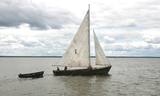 |
Kale is a traditional wooden sailing ship for trawling nets on Lake Võrtsjärv, but its graceful appearance with two triangular sails often inspired pleasure trips too. Võrtsjärve Foundation supported the building of the ship Paula, completed in 2005 and Liisu in 2009. Trips aboard a kaleship are a genuinely memorable experience. |
|
 |
„Zaļmuiža” (Green Manor) is notable because of its legendary past. The protector of peasants and poet Peter
Miglinīks (1850 – 1883) worked there as a clerk in the beginning of the 19th century. In 1784, the building belonged
to Frederick von Korf. The manor was bought by officer of Russian army Nikolaj Paulin von Rosenschild. Once
the manor had a large farm (800 ha): several cattle-sheds, fruit and wine cellars, alcohol brewery. Now there in
only a manor house and a barn. Till 1960s, the manor house was the centre of kolkhoz „Liesma”, later the club.
Now there is a smithy of a craftsman Jānis Ļubka. Guests are welcome to watch and try the metal processing.
|
|
 | ||
 |
Home producer Elma Zadiņa prepares sklandraušs, which have rye flour bottoms, as well as an old Latvian lunch dish - a porridge, using ground wheat and rye flour. The products are produced in small quantities at home. Tasting of porridge and smoothies is possible. |
|
 |
The central part of the town of Krāslava is an historical monument because its low-story and beautiful wooden buildings. The best views of the historical centre relate to the carp park near the Adamova trail, the Karņicskis hill, the bridge across the Daugava (Prospekta Street), and the Priedaine viewing tower on the left bank of the Daugava River. |
|
 |
Based on the tower of a former Soviet army radar installation, there is an 18-metre viewing tower at the Southern breakwater of Ventspils (Medņu Street) today. The tower offers a good view of the port territory, with the sea gate at the mouth of the Venta River and the city beach. Binoculars are available at the tower. It is worth walking down the Southern breakwater to get a better look at the sea.
|
|
 1 day
|
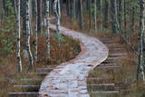
After passing through Sigulda, the Forest Trail follows the River Vējupīte to Paradīzes Hill, where a steep staircase leads down into the ancient valley of the River Gauja and the ravine of the River Vējupīte. It continues to wind down smaller paths through meadows, crossing small rivers whose banks reveal sandstone outcrops. The last six kilometres of this section follow a smaller path down the Līgatne Nature Trails. You can see local wildlife animals and birds on this 5.5 km long trail. Further on the Forest Trail moves up the hills of the ancient valley of the River Gauja, before descending back down into the deep ravine of the River Līgatne, where the village of the former Līgatne paper mill is located. You can explore this attractive small village, visit the Līgatne spoon factory, winery and Līgatne caves. There is also the Līgatne Net Park with 4-7 m high net labyrinths among the treetops. This part of the Forest Trail and Gauja National Park is characterised by a gradual transition from diverse, deciduous forests (ash, grey alder, oak, birch, linden) to coniferous stands. |
|


