
| No | Name | Description |
|---|---|---|
 |
In Otepää wurde am 4. Juni 1884 die estnische Fahne geweiht. Im Pastorat ist ein Zimmer der estnischen Fahne eingerichtet. |
|
 |
The restaurant is in the Park Hotel Latgola with a broad view of the city from the 10th floor. It offers Lettigalian and global cuisine. |
|
 |
Located in the northern part of Valmiera, the Valmiermuiža Estate mansion (Neo-Baroque Style) was built between 1764 and 1771 by Prince August Friedrich of Schleswig, Holstein and Soderburg. Over the course of time it has been owned by other people. According to modern evidence, the mansion was a one-story building with a Baroque tower and a two-story addition in the early 20th century, which made it appropriate as a summer home and hunting lodge. The building burned down in 1918. Two years later, Valmiermuiža became a prison camp for captured soldiers. Later the addition to the mansion was restored and used as an elementary school. In 1936, the building became a prison, and it was once again a prison camp for captured soldiers during World War II. Later the building burned down again, and the ruins were removed. Still surviving is the Valmiermuiža tower, with ceiling paintings that are a cultural monument, as is the surrounding park. The Valmiermuiža brewery is alongside the historical monument, thus providing second wind for the whole region. |
|
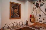 |
The local museum offers an interesting and extensive exhibit related to World War II at the Kurzeme fortress and the fate of Latvian soldiers who took part in the war. There are also exhibits related to the history of World War I and World War II, complete with a collection of civilian and military objects. Among them – a YI-2 airplane, an armoured personnel carrier, a Red Army tank, and all of the trenches and bunkers of the relevant era.
|
|
 |
Based on the tower of a former Soviet army radar installation, there is an 18-metre viewing tower at the Southern breakwater of Ventspils (Medņu Street) today. The tower offers a good view of the port territory, with the sea gate at the mouth of the Venta River and the city beach. Binoculars are available at the tower. It is worth walking down the Southern breakwater to get a better look at the sea.
|
|
 8 days
|
Saaremaa and Hiumaa are the two largest ones amongst 1500 other Estonian islands. In fact Saaremaa is the common name for Muhu and Saaremaa islands which are connected by the causeway like Hiumaa and Kassari islands. |
|
|
|
Bērzes upes labajā krastā, vietā, kur tagad paceļas Dobeles pilsdrupas, jau 1. gadu tūkstotī p. m. ē. atradās zemgaļu apmetne un vēlāk – koka pils. Gandrīz simts gadus pils izturēja vairākus krustnešu uzbrukumus un aplenkumus, un tikai 1289. g., kad vācieši bija pilnībā izpostījuši apvidu un tālāka pretošanās kļuva bezcerīga, zemgaļi paši nodedzināja savu koka pili un neuzvarēti aizgāja uz Lietuvu. 700 gadus vēlāk, 1989. gadā, godinot zemgaļu cilšu piemiņu, bijušās senpilsētas vietā tika atklāta piemiņas zīme, ko veidojis mākslinieks Mārtiņš Zaurs. Akmenī iecirsts teksts: “Zini, no šīs vietas pirms 700 gadiem zemgaļi aizgāja lepni un brīvi”, kā arī dzejnieka Viļa Plūdoņa vārdi : “Mēs svešā malā ejam, bet sirds mums paliek te”. |
|
 |
This is the farm of a moderately wealthy Selonian farmer from the 19th century. It features a residential building with a mantel chimney, two granaries, a threshing barn, a sauna, a windmill, a smithy, a steam locomotive and a threshing machine. Groups will enjoy thematic programmes such as “Crafts at the Selonian Farm,” “When Honey Melts on Your Tongue,” and “A Wedding at the Selonian Farm.” |
|
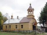 |
Viļāni Old-Believers Prayer House. The architect P.Pavlovs built Old-Believers Prayer House in 1930s.
The congregation was established very recently. Nevertheless the 14 meters high tower was constructed in
2004. The Prayer House is a very simple building but you will be pleased to see the magnificent icons. The
Prayer House has been renovated completely.
|
|
 5 days
|
This route involves unique views that have never been seen before in Latvia! The impressively steep shoreline of the Baltic Sea begins a few kilometres to the North of Pāvilosta and ends shortly before Ošvalki, stretching for nearly 20 kilometres in all. Its most impressive and unusual forms are seen between Strante and Ulmale. The entire route leads down the western boundary of the former Iron Curtain, because the Baltic Sea coastline was militarised during the Soviet era and unavailable to most people. Remnants of former military objects and old tank routes in the dunes can still be seen. The largest biotopes of grey dunes stretch for several kilometres around Ventspils and Užava. These are unusual landscapes that can seldom be seen elsewhere in Europe. You can walk more than 10 kilometres here and not see another soul. Route information from Latvijas Lauku forums |
|
 |
Rancho Riisa is located in Soomaa National Park (Soomaa Rahvuspark), where there are a lot of fruits of the forest to be used in cooking. After a stroll through the national park and a refreshing sauna, the hosts will offer the best meal in Soomaa traditions. |
|
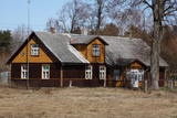 |
This set of buildings represents a homestead for a fisherman and a farmer. The house was built in 1926, and the ancillary buildings all date back to the first half of the 20th century. The homestead can be seen from the road. |
|
 |
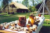
In the workshop it is possible to learn about the process of creating and the usage of pottery of different historic periods, as well as other household goods. Archaeological pottery is presented. The Middle Ages man-carried clay bread oven, frying-pan, drinking cups, the pilgrims’ water bowls. All the works are handmade in the moulded ceramics style and burned in the clay kiln. |
|
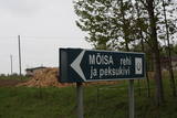 |
Neliela apdzīvota vieta nacionālā parka ziemeļrietumu daļā, kur kādreiz atradusies Rebases muiža. Mūsdienās no tās saglabājušās klēts atliekas, pie kurām apskatāms interesants vēstures liecinieks – sens akmens, ko izmantoja kulšanas procesā (Peksukivi). |
|
 |
This is a single-family farm, and visitors are welcome to tour it and see white peacocks, pheasants, ducks, chickens, French cattle and white genetic fund pigs from Lithuania. |
|
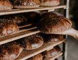 |
SIA N. Bomja bakery “Lielezers” is a sole proprietor enterprise of Normunds Bomis, founded in 1991 and located 3 km from Limbaži. The story of this bakery started more than 25 years ago, when craftsman Alberts Blumbergs’ knowledge and experience was put into practice and very delicious rye bread was made. In the bakery, traditional salinātā rye bread is made by hand, maturing scalded flour in aspen tubs for 24 hours and fermenting with sourdough. Salinātā rye bread is registered in the EU food quality scheme as a product with traditional speciality guaranteed. Bread baking is led by the experienced master bakers Lāsma Bome and Valters Kanopa. Offer tours in the bakery and tasting. |
|
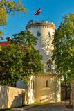 |
Cēsis is in the centre of the Gauja National Park, but it is not part of the park as such. There are many interesting places in Cēsis to visit and examine. The oldest part of the town is of key interest. The origins of Cēsis can be found at Riekstu hill, which is 18 metres high. Between the 11th and 13th century, there was a wooden castle here built by the Vendians. The hill is in the central part of the castle park, and it offers a good view of the park, pond and the ruins of the Cēsis castle, which can be accessed via a long cascade of stairs. The Cēsis castle (see below) was built in the early 13th century as a residence for masters of the Livonian Order, and it was one of the strongest fortresses in the Baltic territories. Alongside it is the New Cēsis castle, which was built in 1777 where the gate fortifications once stood. The Cēsis Museum of History and Art is in the building, alongside which is a visitors centre and the Cēsis Tourism Information Centre. From the tower of the castle, there is a fine view of the castle ruins, St John's Lutheran church and the northern part of the town. Opposite the New Cēsis castle are stables and a wheelhouse (both from the first half of the 19th century). The Cēsis Exhibition Hall is there today. You can look at the exteriors of the granary, the hut for coachmen, and the old brewery. On the other side of the street is the romantic Maija park, which was installed in the 1830s. The park is popular among parents with children, because there is a playground there. From this area, you can walk down some of the old streets of the town – Lielās Katrīnas, Mazās Katrīnas, Mazā Kalēju, Kalēju and Lielā Līvu streets, plus Līvu Square. The wooden buildings along the streets date back to the late 18th and early 19th century. Torņa Street, which weaves its way along the defensive walls of the Medieval castle, offers a look outside the church of a sculpture by Matiass Jansons, "As the Centuries Pass". Legend says that if you rub the lantern carred by the Old Man of Time, you can see the future. One of the most impressive buildings in Cēsis is St John's Lutheran Church, which was built in the late 13th century for the Livonian Order. It is a basilica built in the Roman style and with Gothic elements. The tower, which is 65 m high, was built in 1853. The building was reconstructed several times during the 20th century. Inside the building are grave epitaphs for masters of the Livonian Order and for bishops. The pulpit was installed in 1748, the oak altar followed in 1858, and the altar painting "The Crucified One" dates back to 1862. The stained glass windows around the altar are of great artistic value. The organ was built in 1907 by the E.F. Walker Company, and the instrument is one of the best concert organs in Latvia. A sun clock featuring the year 1744 is at the south-western corner of the church. It is worth climbing the church's tower. At the foot of the building is Rose Square, which began as a market square in the mid-19th century, remained in place until 1927, and was restored in 2008. This is the central square in the town today. During the Medieval Era, there were stockades here, along with the city's well. Rīgas Street has been the main street of the old town from the very beginning, and it is here that you will find the most architecturally outstanding buildings in town from the 18th and 19th centuries. They include the former Cēsis City Hall, the Fābers building, and the Princess building. At one end of the street is Līvu Square, where, during the 13th century, there was a church, a cemetery and a gate in the town walls. Today the square features a lighted fountain which is on the site of a 13th century well known as Lejas Šķimbēgs. At the other end of the street is a reconstruction of the foundations and surface elements of the Rauna gate that was a part of the town walls in the 14th and 15th centuries. The site offers a good idea about Medieval fortifications and the size and mightiness of gates therein. |
|
 |
Located in the centre of Ventspils next to the Town Hall Square. Enjoy typical Latvian cuisine in a pleasant atmosphere. |
|
 |
The café is in the centre of Ludza with a lovely view of local churches and a castle hill. Lettigalian foods made of various ingredients are offered. |
|
|
|
Daugavas aizsargdambju būvniecību Jēkabpilī uzsāka pēc 1981. gada lielajiem paliem, kad ūdens līmenis pārsniedza kritisko - 6,3 m atzīmi un pakāpās līdz rādījumam „8,7 metri”. Šo plūdu laikā puse pilsētas klāja Daugavas ūdeņi. 2011. gada vasarā notika plašāki dambja atjaunošanas un labiekārtošanas darbi. Pie tā uzstādīja laternas, soliņus, izveidoja pastaigu promenādi un piemiņas zīmi Daugavas kreisajā krastā, kas parāda maksimālo plūdu līmeni. Uz aizsargdambja Daugavas labajā krastā ir izvietoti informatīvie stendi, kur var uzzināt daudz interesantus faktus par pilsētas vēsturi. Dambji ir piemērota vieta, kur fotografēt vai gleznot pilsētas ainavas. |
|


