
| No | Name | Description |
|---|---|---|
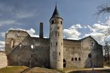 |
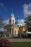
This is one of several remarkable medieval strongholds in Estonia; the convent house, mysterious cellars and displays with numerous finds and exhibits are open to visitors; the children’s playground in the courtyard contains attractions inspired by the Middle Ages. |
|
 |
Saimniecība "Baltiņi" atrodas Auces novadā un nodarbojas ar lopkopību un lauksaimniecību. Viesiem ir iespēja redzēt un izzināt piena ražošanas procesu, kā arī iepazīt saimniecības dzīvniekus. Saimnieki piedāvā apskatīt padomju laiku auto kolekciju, pieejama arī suvenīru un trauku kolekcija ar govs motīviem. |
|
 |
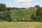
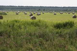
A small settlement on the banks of the River Daugava, between Aizkraukle and Jaunjelgava. Skriveru region is associated with the life and work of popular Latvian author A. Upitis. Near Skriveri lies the oldest arboretum in Latvia. Its establishment in 1891 was started by the owner of Skriveru manor Maximilian von Siverss. In the park there are about 400 plant species, varieties and forms. One of the finest views of the Daugava will open from the so-called Krauklu Mountains – steep upper part of the right riverbank, which is an ancient hill fort. |
|
 |
Krustpils was first recorded in documents in 1237 in relation to the construction of the Kreutzburg castle on the right bank of the Daugava River. A 1511 document lists it as a village. In 1585, Polish King Stefan Báthory gifted the town to Nicholas Korff, whose family continued to own it until 1920. Battles between Swedish and Polish forces occurred outside of Krustpils in 1626, and the sacked village was in poor shape until the mid-19th century. Jēkabpils, in turn, was constructed as a settlement for Old Believers who were persecuted in Russia. The Daugava has rapids opposite Krustpils and Jēkabpils, which means that boats had to dock there and reload their goods into wagons. The settlement flourished, and in 1670 it was given the rights of a city. It is named after Duke Jacob. When the Rīga-Daugavpils rail line opened in 1861, Krustpils flourished, and Jēkabpils did not flourish. The two cities were administratively merged in 1962, keeping the name of Jēkabpils. There are typical one-story wooden buildings from the 19th century, red brick buildings built at the turn of the 20th century, as well as seven churches used by different denominations. The dam along the left bank of the Daugava was built in 1861, and it was aimed at protecting the city against flooding. Today it is a promenade that is popular among local residents for strolling and leisure. |
|
 |
At Estonia's oldest and largest beverage producer, brewery A. Le Coq, visitors of the brewery museum are invited to get acquainted with the history of beer brewing and beer culture, modern beer production as well as taste the beer. More than 2000 exhibits, opportunity to taste beer and other delicacies in the tavern of museum. You can buy beer and snacks to go with it, as well as souvenirs in the small store of the museum. |
|
 |
"Sabiles laivas" Talsu novadā piedāvā laivu nomu, laivu un laivotāju transportu. |
|
 |
Находится в стороне от площади Куршу, ул. Э.Венденбаума, д. 1. Старейшая церковь города, сведения о которой сохранились с 1508 года. Первый храм на этом месте был построен из дерева. После неоднократных перестроек (последняя – в 1893 г. под руководством архитектора Лиепаи Пауля Макса Берчи) храм приобрел теперешний вид в неоготическом стиле с башней высотой около 60 м. Церковный интерьер славится одним из самых выдающихся шедевров времен барокко в Латвии – алтарем (резчик по дереву Николя Сефренс младший), который в 2012 году отметил свое 350-летие.Алтарь считается одной из самых выдающихся работ Восточной Европы того времени. Ретабло алтаря (5,8 x 9,7 м) известно тематическим циклом страданий Иисуса. В храме находится третий по величине орган Латвии, который построен по эскизам композитора и органиста Альфреда Калниньша. Церковь можно осмотреть изнутри и подняться на колокольню. |
|
 |
In the centre of the Old City, on the corner of Latgales and Baznīcas streets, the church was built in the style of Russian Classicism between 1843 and 1845. The ceiling and wall paintings were recently restored, and the bell in the steeple weighs 1,667 kg. |
|
 |
Atrodas 1905. gada ielā 6. Sinagoga tika celta 1875. g. – Krievijas cara Aleksandra II valdīšanas laikā. Pēc 2. pasaules kara tajā atradās graudu noliktava, kinoteātris, kafejnīca un visbeidzot – naktsklubs. No 2003. gada to vairs neizmantoja. Pirms gada tika pabeigts vērienīgs projekts - sinagogas un lūgšanu nama atjaunošana, kurā izveidots sabiedrībai pieejams kultūras un informācijas centrs un pārcelta Kuldīgas novada bibliotēka. |
|
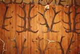 |
Found at the Purvziedi homestead in Vaide, this collection of more than 600 horns has been established by forest guard Edgars Hausmanis, who says that he found all of the exhibits in the forest. |
|
 |
Das alte zemgalicshe wirtschaftspolitische Zentrum, das eine stark befestigte Siedlung vor der Ankunft der Kreuzritter war. Die Ruinen der Burg des Livländischen Ordens. |
|
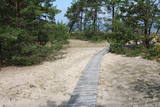 |
The trail (the length 1.2 km) introduces with the habitats of dunes and century-old pines, partly covered with sand. Biologists estimate that the oldest tree, the “mother of pines”, could be around 200 years old. Coastal pine forests serve as a barrier between the sea and land protecting inland areas from impact of the sea and winds. Felling coastal forests was forbidden by law already back in 1643, during the Duchy of Courland. Still due to economic activities, the seashore forests were often fell and fires occurred there occasionally. As a result, the sand which had for centuries been hold by trees, started drifting at Cape Kolka. In the 1930ies, there were about 142 hectares of sandy areas in the Slītere National Park, and 11.5 hectares of those were drifting sand. To stop drifting, the sand areas were carefully afforested. Afforestation was started before WW I and it was completed in the 1970ies. To plant new trees, first the sand had to be stopped. Just 26km to the south from Kolka there was one of the largest sand dunes in Latvia, 25km in length. Every year it devoured 0.3 hectares of land. The sand was stopped covering it with heather, twigs and branches of pines and junipers. Pine trees were planted between them. Today in Kolka, the old, low pine trees tell about the once drifting sand. After storms, when the water washes the bluff and tree roots are exposed, one can see that the tree trunks once have been covered with sand more than 1 meter high. The trees on the seacoast usually have crooked trunks and flag-shaped crowns formed under influence of persisting sea winds. Now these forests are designated biotope “Wooded dunes of the coast”. Stable white dunes (biotope 2120) do not form in Cape Kolka as they are washed by sea waters during spring and autumn storms. Embryonic dunes develop here (code 2120) with plants that usually grow in dunes. These plants have adapted well to poor soils, heat, drought, and the saline sea water. The Kolkasrags Pine Trail is in Slītere National Park. |
|
 |
Volzbahs ir stāva nogāze ar elpu aizraujošu skatu pāri gravai. Ziemā šeit pieejams vairāk nekā 100 m garš nobrauciens ar slēpēm, sniega dēli vai ragaviņām. Citos gadalaikos Volzbaha kalns ir lieliska atpūtas vieta- šeit ir labiekārtota vieta piknikam, pastaigām, foto sesijām. Rudenī Volzbaha kalns ir viena no labākajām vietām Vaiņodes novadā, kur vērot krāšņos rudens skatus. Volzbahs atrodas 2 km no Vaiņodes centra ZR virzienā. Kalnam ērti var piebraukt klāt ar automašīnām. Adrese: Vaiņodes pagasts, Dienvidkurzemes novads, LV-3435 Facebook: facebook.com/biedribavolzbahs Twitter: Volzbahs |
|
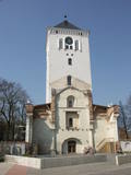 |
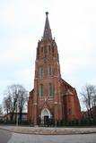
Work on a new church began in 1574 at the commission of Duke Gotthard Kettler of Courland and Zemgale. The steeple was installed between 1686 and 1688, and in 1862 its height was increased to 80.5 m. The church burned down because of Soviet bombardment on July 27, 1944, and in 1954 the Soviet military blew up its ruins. Reconstruction of the steeple began in 2009, and it now has an outstanding interactive museum that is particularly interesting for children, along with a glassed viewing platform. |
|
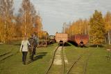 |
Sedas purva kājnieku maršruts atrodas dabas liegumā Sedas purvs, pārgājienu pa maršrutu iespējams apvienot ar Sedas pilsētas apskati, kas ir unikāls 20.gs. 50.–60. gadu pilsētbūvniecības un arhitektūras paraugs - kūdras purva strādnieku pilsēta. Maršrutam ir divi apļi - Jērcēnu aplis - 5,5 km un Sedas aplis - 4,2 km. Tajos apakatāms izstrādātais kūdras purvs, šaursliežu dzelzceļš, ritošais sastāvs, divi skatu toņi. Rudenī un pavasarī - putnu migrācijas lāikā - interesanta vieta putnu vērošanai. GPS koordinātes: Jērcēnu puses aplim: 57.7055987, 25.7001324; Sedas puses aplim: 57.6699587, 25.7514815. |
|
 |
The Aknīste Regional Research Museum is at the corner of Skolas and Miera streets in Aknīste. It is another location which will very much help you to learn about the culture and history of the Selonian region. The museum was established in 1998 and featured antiquities from the Iron Age and Bronze Age, as well as objects which speak to distinguished people from the region and Selonian culture. It is worth looking at the collection of ancient Selonian dishware. |
|
 |
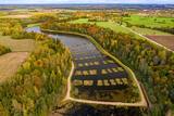
Open landscape area within farming lands on both banks of Uzava River about 10 km before it flows into the Baltic Sea. There is a good open view over the area from the Vendzava-Ziri road going through the nature park. Protection of migratory birds and corncrakes has been one of the main reasons for establishment of the nature park. Bird watching is possible from the road Vendzava-Ziri during migration period in spring and fall. There is no tourist infrastructure in the nature park.
|
|
 |
The current Ventspils airport began its life as a military object. Today regular passenger flights to and from Rīga have been suspended, and the airport is only used for small planes.
|
|
 |
Near the place where the Kilmiņupe River flows into the sea is the legendary Trommel castle hill, which was a Medieval fortification. It is some 100 m from the Kraujas homestead. An archaeological dig in 1977 found fragments of bricks and pot-bellied stoves, which suggests that the fortifications date back to the Middle Ages. The location also is linked to stories about a pirate, Trommel, who buried his loot here. The holes in the area have been left behind by treasure hunters. Trommel supposedly robbed ships in the Bay of Rīga from the shores of Kurzeme to Roņu Island. Many ships docked here in ancient times, waiting for better winds so that they could pass by Cape Kolka. The pirate made use of this fact, also pillaging property from sunken ships. It is said that Trommel lived in a stone castle. (Source: Roja TIC) |
|
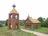 |
One of the most unusual houses of worship in the national park, this one has a red brick tower, and together with local residential buildings it makes up an interesting cultural landscape. The prayer house is not open to the public. |
|


